
Deutsch-Chinesische Enzyklopädie, 德汉百科
 Ningxia Huizu Zizhiqu-NX
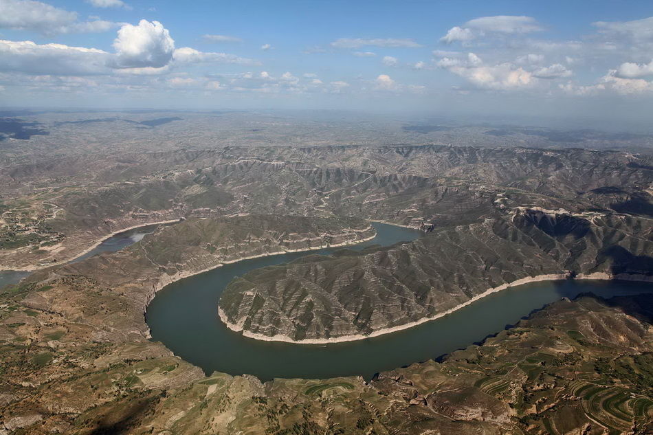


Das Helan-Gebirge bzw. Helan Shan (chinesisch 贺兰山) ist ein nordwestlich von Yinchuan gelegener über 200 km langer und 15–50 km breiter, durchschnittlich mehr als 2000 m hoher Gebirgszug, der die Grenze zwischen der Inneren Mongolei und Ningxia bildet. Sein höchster Gipfel ist 3556 m hoch.
贺兰山(突厥语“贺兰”意为“骏马”),又名阿拉善山(蒙古语:![]() ;,鲍培转写:Alaša aɣula,西里尔字母:Алшаа уул)[1],位于中国宁夏回族自治区与内蒙古自治区的交界,地处银川平原与阿拉善高原之间,南北走向,长度约270千米,主峰敖包圪瘩海拔高3556米。贺兰山是中国西北地区的地理界线,西北为阿拉善高原和腾格里沙漠,东为银川平原和鄂尔多斯高原,自古为中国兵家必争之地。
;,鲍培转写:Alaša aɣula,西里尔字母:Алшаа уул)[1],位于中国宁夏回族自治区与内蒙古自治区的交界,地处银川平原与阿拉善高原之间,南北走向,长度约270千米,主峰敖包圪瘩海拔高3556米。贺兰山是中国西北地区的地理界线,西北为阿拉善高原和腾格里沙漠,东为银川平原和鄂尔多斯高原,自古为中国兵家必争之地。


 Anhui Sheng-AH
 Beijing Shi-BJ
 Gansu Sheng-GS
 Hebei Sheng-HE
 Henan Sheng-HA
 Liaoning Sheng-LN
 Nei Mongol Zizhiqu-NM
 Ningxia Huizu Zizhiqu-NX
 Shandong Sheng-SD
 Xinjiang Uygur Zizhiqu-XJ
 Yunnan Sheng-YN
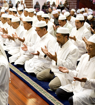


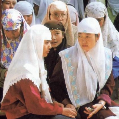
回族是中国人口较多的一个少数民族,中国的31个省、自治区、直辖市均有分布。宁夏回族自治区是其主要聚居区,宁夏回族自治区拥有回族人口186.25万,占全国回族总人口的18.9%。另外,回族人口在20万以上的地区还有:北京、河北、内蒙古、辽宁、安徽、山东、河南、云南、甘肃和新疆等。
回族的族源可以追溯到唐代,学术界一般认为回族大致形成于明代,而元代是回族形成的准备时期,明代是回族最终形成的时期。各地回族还以不同的形式参加反抗帝国主义侵略的斗争,五四运动和中国共产党成立,为回族人民的彻底解放指明了方向。
不论在政治、经济、文化上,回回民族在历史上都涌现过不少杰出的人物,对当时人民生活和生产建设都作出了积极的贡献。
根据《中国统计年鉴-2021》,中国(不包括台湾省)境内回族的人口数为11377914人。

Die Hundertacht Pagoden bzw. Hundertacht Dagobas (chinesisch 一百零八塔, Pinyin Yībǎilíngbā tǎ) am Westufer des Gelben Flusses ca. 20 km von Qingtongxia (青铜峡市) entfernt, in Ningxia, China, reihen sich in einem Dreieck an einem Berghang angelehnt in zwölf Reihen von 1, 2×3, 2×5, 7, 9, 11, 13, 15, 17, 19 Stück. Sie stammen aus der Zeit der Yuan-Dynastie.
Eine solche Pagodengruppe ist einzigartig in der chinesischen Architektur. Die Zahl 108 bezieht sich möglicherweise auf die 108 Dharmakörper (Dharmakaya) über die im Vajrashekhara-Sutra (Sutra der Diamantkrone) berichtet wird.[1]
 Beijing Shi-BJ
 Gansu Sheng-GS

 History
 L 1000 - 1500 AD
 Hebei Sheng-HE
 Heilongjiang Sheng-HL
 Jilin Sheng-JL
 Liaoning Sheng-LN
 Nei Mongol Zizhiqu-NM
 Ningxia Huizu Zizhiqu-NX
 Qinghai Sheng-QH
 Shaanxi Sheng-SN
 Shanxi Sheng-SX
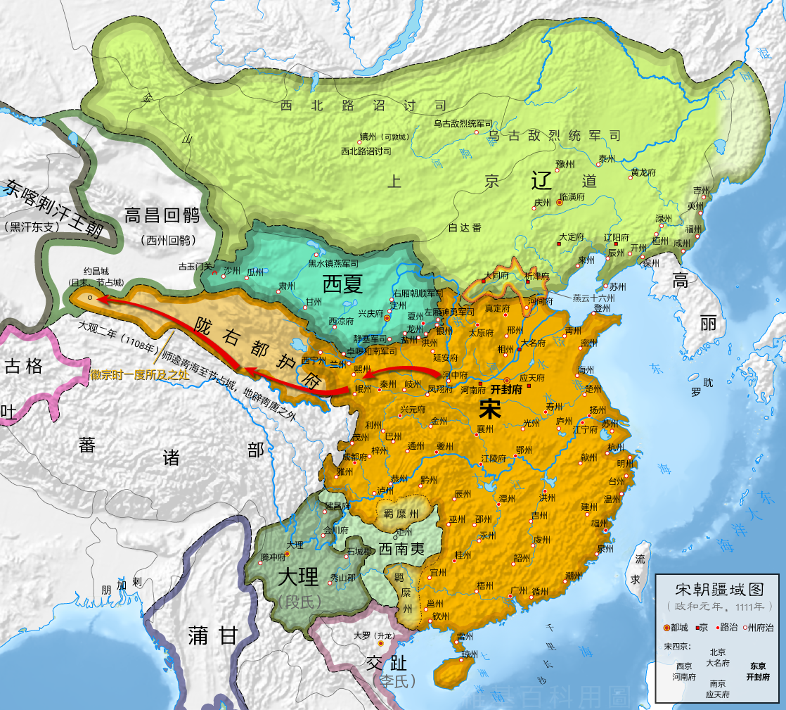
辽朝(907年-1125年),国号大辽,又称大契丹国(契丹国,契丹大字:![]() )[注 1],是中国历史上由契丹人建立的一个朝代,国祚210年[2]。
)[注 1],是中国历史上由契丹人建立的一个朝代,国祚210年[2]。
契丹族首领耶律阿保机吞并了契丹各个部落后,于916年称帝建国“契丹”。918年定都临潢府(今内蒙古巴林左旗南)。契丹屡次南下中原,946年阿保机之子耶律德光攻灭后晋后确定国号为“大辽”[注 2],983年改为“契丹”,1066年改为“大辽”[3],直到1125年3月26日为金朝所灭为止。除了辽朝之外,契丹族尚建立相关国家。1122年,天祚帝北逃夹山,耶律淳于辽南京被立为帝,史称北辽[3]。辽朝灭亡后,耶律大石西迁到中亚楚河流域,1132年建立西辽。1211年西辽被屈出律篡位,1218年被蒙古帝国所灭。
史学界对“契丹”含义最广为接受的说法是镔铁或刀剑之意。后来改国名为“辽”也是“铁”的意思,同时“辽”也是契丹人发祥地辽水的名字,以示不忘本之意。又因与南方的中原政权长期对峙,而称“北朝”,而称中原王朝为“南朝”[4]。辽朝926年灭渤海国,938年据燕云十六州,后灭后晋,自居为继承后晋的中原正统,即使之后退回北方。依据五行德运说的五行相生规律,后晋的“木”德之后为“水”德,因此辽朝以水为德运,并相应以黑色为正色。[5]
辽朝全盛时期疆域东到日本海,西至阿尔泰山,北到额尔古纳河、大兴安岭一带,南到河北省南部的白沟河。契丹族本是游牧民族,辽朝皇帝使农牧业共同发展繁荣,各得其所,建立独特的、比较完整的管理体制。辽朝将重心放在民族发祥地,为了保持民族性将游牧民族(契丹人)与农业民族(汉人)分开统治,主张因俗而治,开创出两院制的政治体制。并且创造契丹文字,保存自己的文化。此外,吸收渤海国、五代、北宋、西夏及西域各国的文化,成效地促进辽朝政治、经济和文化各个方面发展。辽朝的军事力量与影响力涵盖西域地区,因此在唐朝灭亡后中亚、西亚与东欧等地区常将辽朝(契丹,英语作Cathay)当做中国,[6]。
Die Liao-Dynastie (chinesisch 遼朝 / 辽朝, Pinyin Liáocháo) war eine Dynastie im Norden Chinas von 916 bis 1125. Das Herrscherhaus und ein Teil der Untertanen waren Angehörige des (proto-)mongolischen Volks der Kitan. Der Dynastie-Gründer war Abaoji († 926).
遼(りょう、簡体字:辽、拼音:Liáo)は、遼朝(りょうちょう)ともいい、内モンゴルを中心に中国の北辺を支配した契丹人(キタイ人)耶律氏(ヤリュート氏)の征服王朝。916年から1125年まで続いた。中原に迫る大規模な版図(現在の北京を含む)を持ち、かつ長期間続いた最初の異民族王朝であり、いわゆる征服王朝(金、元、清が続く)の最初とされる。ただし、後の3つの王朝と異なって中原を支配下にはおいていない。
The Liao dynasty (/ljaʊ/;[5] Khitan: Mos Jælud; traditional Chinese: 遼朝; simplified Chinese: 辽朝; pinyin: Liáo cháo),[6] also known as the Liao Empire, officially the Great Liao (大遼; 大辽; Dà Liáo), or the Khitan (Qidan) State (Khitan: Mos diau-d kitai huldʒi gur),[7] was an empire in East Asia that ruled from 907 to 1125 over present-day Northern and Northeast China, Mongolia and portions of the Russian Far East and North Korea.[8] The empire was founded by Yelü Abaoji, Khagan of the Khitans around the time of the collapse of Tang China and was the first state to control all of Manchuria.[9]
Almost immediately after its founding, the Khitan Empire began a process of territorial expansion, with Abaoji leading a successful conquest of Balhae. Later emperors would gain the Sixteen Prefectures by fueling a proxy war that led to the collapse of the Later Tang (923–936) and would establish tributary relationships with Goryeo after losing in Goryeo–Khitan Wars (1018) against Goryeo.[10] In 1004, Liao Dynasty launched an imperial expedition against the Northern Song. After heavy fighting and large casualties between two countries, the two sides worked out the Chanyuan Treaty. Through the treaty Liao forced the Northern Song to recognize them as peers.
Tension between traditional Khitan social and political practices and Chinese influence and customs was a defining feature of the dynasty. This tension led to a series of succession crises; Liao emperors favored the Chinese concept of primogeniture, while much of the rest of the Khitan elite supported the traditional method of succession by the strongest candidate. So different were Khitan and Chinese practices that Abaoji set up two parallel governments. The Northern Administration governed Khitan areas following traditional Khitan practices, while the Southern Administration governed areas with large non-Khitan populations, adopting traditional Chinese governmental practices.
Differences between Chinese and Khitan society included gender roles and marital practices: the Khitans took a more egalitarian view towards gender, in sharp contrast to Chinese cultural practices that segregated men's and women's roles. Khitan women were taught to hunt, managed family property, and held military posts. Many marriages were not arranged, women were not required to be virgins at their first marriage, and women had the right to divorce and remarry.
The Liao dynasty was destroyed by the Jurchen-led Jin dynasty in 1125 with the capture of Emperor Tianzuo of Liao. However, the remnant Khitan, led by Yelü Dashi, established the Qara Khitai (Western Liao dynasty), which ruled over parts of Central Asia for almost a century before being conquered by the Mongols. Although cultural achievements associated with the Liao dynasty are considerable, and a number of various statuary and other artifacts exist in museums and other collections, major questions remain over the exact nature and extent of the influence of the Liao Khitan culture upon subsequent developments, such as the musical and theatrical arts.
La dynastie Liao (chinois simplifié : 辽朝 ; chinois traditionnel : 遼朝 ; pinyin : ; Khitan : Mos Jælud)1, également connue sous le nom d'Empire Khitan (chinois simplifié : 契丹国 ; chinois traditionnel : 契丹國 ; pinyin : ; Khitan : Mos diau-d kitai huldʒi gur)2, est un empire d'Asie orientale qui a régné sur la Mongolie, une partie de la Russie orientale et du nord de la Chine continentale entre 907 et 1125. Elle a été fondée par le Khagan Khitan Yelü Abaoji à la suite de la chute de la dynastie chinoise Tang.
Bien que couvrant essentiellement les steppes mongoles et quelques provinces du Nord de la Chine actuelle, la majorité de la population sous le contrôle de la dynastie était d'origine Chinoise Han. Le gouvernement Khitan a donc instauré un système administratif inédit visant à prendre en compte les spécificités de chaque partie du territoire, afin de mieux contrôler les populations locales. Cette période fut également une étape importante pour les Khitans, qui formalisent leur langue écrite à cette époque et commencent à intégrer de plus en plus les coutumes traditionnelles des Chinois Han.
L'empire a été détruit par les Jürchens de la dynastie Jin en 1125. Toutefois, certains survivants du peuple Khitan, menés par Yelü Dashi, ont établi la dynastie des Liao occidentaux. Connue également sous le nom de Khanate Kara-Khitans, cette dynastie a régné sur des parties de l'Asie centrale pendant près d'un siècle, avant d'être conquise à son tour par l'armée mongole de Genghis Khan.
La dinastia Liao (cinese tradizionale: 遼朝; cinese semplificato: 辽朝; pinyin: Liáo Cháo), 907-1125, conosciuta anche come impero Kitai (契丹國 / 契丹国 / Qìdān Guó), fu una dinastia che regnò sulle regioni della Manciuria, della Mongolia e su parte della Cina settentrionale. Fu fondata dalla tribù Yelü (耶律 Yēlǜ) del popolo Kitai nell'ultimo periodo della dinastia Tang, anche se il primo sovrano, Ābǎojī (阿保機 / 阿保机), proclamò il primo periodo di regno solo nel 916.
Nel 947 (o secondo altre fonti nel 938) l'imperatore Yelü Ruǎn adottò ufficialmente il nome "Liáo" (formalmente "Grande Liáo"). Abbandonato nel 983, il nome fu poi ripreso nel 1066.
Il regno dei Liao fu distrutto dagli Jurchi della dinastia Jīn nel 1125. I superstiti, guidati da Yelü Dashi, fondarono la dinastia Liao occidentale 1125-1220 o Kara Khitay, che sopravvisse fino all'arrivo dell'esercito mongolo di Gengis Khan.
La dinastía Liao (chino tradicional: 遼朝, chino simplificado: 辽朝, pinyin: Liáo Cháo, Wade-Giles: Liao2-Ch'ao2, kitán: Mos Jælut),12 907-1125, también conocida como Imperio kitán (契丹國 pinyin: Qìdān Guó, kitán: Mos diau-d kitai huldʒi gur)3 fue una dinastía china, de origen extranjero, que gobernó gran parte del nordeste del territorio chino actual.
Los kitán, uno de los grupos étnicos tunguses, de origen altaico, que habitaban hace siglos en la actual Manchuria, fundaron en el año 907 un estado que recibió inicialmente el nombre de Estado Kitán. Más adelante, tras conquistar el norte de China, el estado asumió formas de gobierno de estilo chino tomando el nombre dinástico de Liao, por el río del mismo nombre (en la actual provincia china de Liaoning) de su tierra ancestral. El imperio de los Liao convivió con la dinastía Song, al sur, y con el Imperio Tangut (o Xia Occidental), que gobernaba parte del noroeste chino.
El imperio de los kitán cayó definitivamente en el año 1125, derrotado por otro pueblo altaico, los yurchen, que conquistaron el territorio de los Liao, y fundaron su propia dinastía, la Jin.
Del nombre "kitán" deriva el nombre "Catay" con el que se conoció a China en Europa durante la Edad Media. El nombre actual de China en ruso (Kitái), mongol (Qitad) y uigur (Hitay) tiene también este mismo origen.
Ляо (монг. Кидан улс, кит. трад. 遼朝, упр. 辽朝, пиньинь: Liao chao, палл.: Ляо Чао) — государство кидань-монголов, которое занимало просторы Северо-Восточного Китая с момента основания киданьской государственности племенным вождём Абаоцзи (Амбагай) в 907 году до мятежа чжурчжэней в 1125 году. Столицы — Шанцзин (верховная, ныне Хуэйнинфу), Ляоян (восточная), Датун (западная), Наньцзин (южная, в районе современного Пекина).
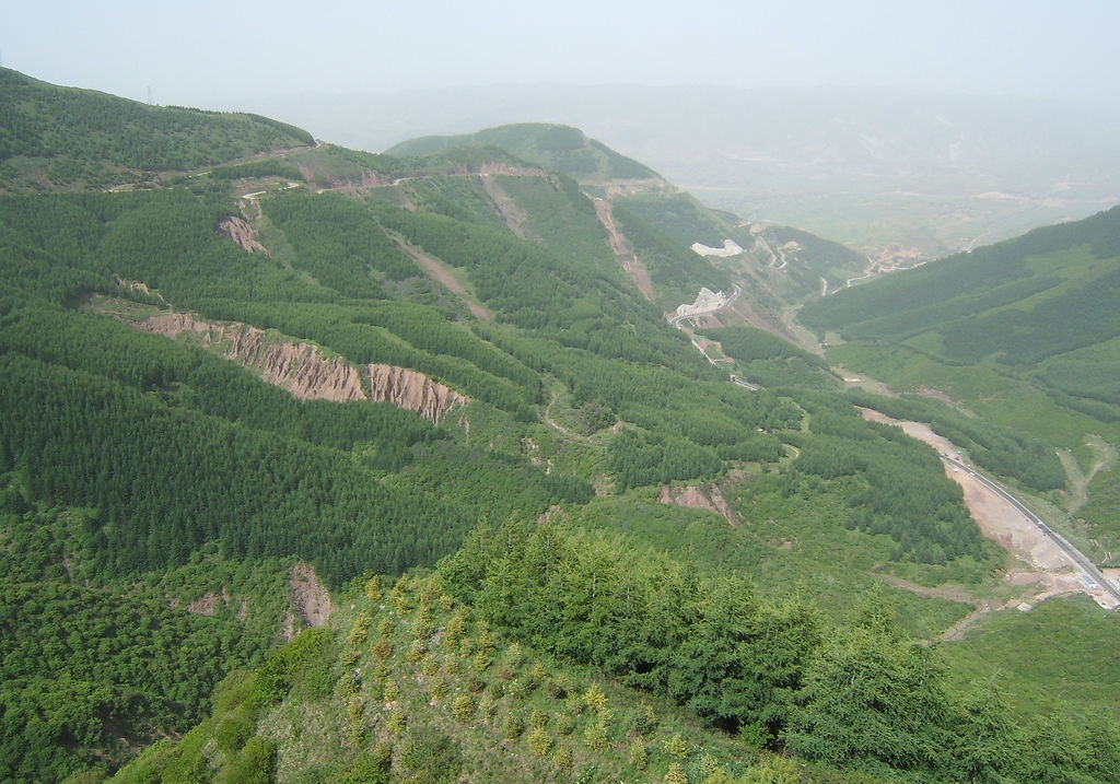
Das Liupan-Gebirge (Liupan Shan 六盘山, auch Liupan Shanmai 六盘山脉 oder (für den südlichen Teil) Long Shan 陇山) in Süd-Ningxia und Ost-Gansu ist einer der wenigen von Norden nach Süden verlaufenden Gebirgszüge Chinas im Grenzgebiet der chinesischen Provinzen Ningxia, Gansu und Shaanxi. Es ist ca. 240 km lang und bildet die Wasserscheide zwischen den Flüssen Wei He 渭河 und Jing He 泾河. Sein Hauptgipfel ist der Migang Shan 米缸山 an der Grenze von Jingyuan 泾源 und Longde 隆德 mit 2.942 Metern.
 *Yellow river
 China
China
 Gansu Sheng-GS
 Henan Sheng-HA
 Nei Mongol Zizhiqu-NM
 Ningxia Huizu Zizhiqu-NX
 Qinghai Sheng-QH
 Shaanxi Sheng-SN
 Shanxi Sheng-SX
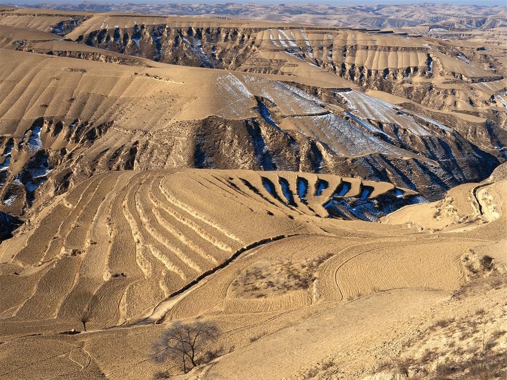
Das Lössplateau, Löss-Hochland (Huangtu gaoyuan 黃土高原) oder Löss-Bergland in Huabei (Nordchina) ist eine Hochlandstufe, die den Übergang vom Nordchinesischen Tiefland zum Hochland der (Inneren) Mongolei im Norden sowie dem Hochland von Tibet im Westen darstellt. Der Südrand wird durch die ebenfalls von Löss geprägten Gebiete im Flusstal des Gelben Flusses sowie dessen wichtigstem Nebenfluss, den Wei He, gebildet, die im Süden von den felsigen Gebirgsketten des Qin Ling überragt werden. Das Lössplateau dehnt sich ungefähr 1000 km ost-westlich und 700 km nord-südlich aus und umfasst weitgehend die Provinzen Shanxi und Shaanxi sowie Teilregionen der Provinzen Hebei, Henan, Gansu, Qinghai und der Inneren Mongolei. Die Lössschichten im Bergland der Provinzen Henan, Shaanxi, Shanxi und Gansu sind bis zu 300 m mächtig.
Traditionell haben die Bewohner dieser Gebiete ihre Behausungen häufig in den Löss hinein gearbeitet. Die Lösswohnungen zeichnen sich durch ein ausgesprochen angenehmes, ausgeglichenes Raumklima aus, das die Temperaturextreme der kalten Winter und heißen Sommer besser abzumildern vermag als moderne Neubauten.
Der Löss ist als äolisches Sediment, das vor allem aus Schluff besteht, ein aus den innerasiatischen Wüsten und Steppen ausgeblasenes Feinmaterial. Der verfestigte Flugstaub ist gelbbraun und äußerst nährstoffreich. Im ostasiatischen Lössbergland finden sich die weltweit mächtigsten Lössablagerungsschichten.
Entlang des Gelben Flusses, der seinen Namen von den mitgeführten Sedimenten hat, steht er in Ablagerungsschichten von bis zu 400 m an. Weltweit verfügt kein Fluss über eine stärkere Sedimentfracht, fast 40 Kilogramm pro Kubikmeter Wasser. Auf Grund der Sedimentation erhöht der Gelbe Fluss sein Bett im Tiefland und muss durch immer höhere Deiche eingedämmt werden. Bei Kaifeng und Zhengzhou liegt der Wasserspiegel bereits zehn Meter über dem Umland.
 Geography
 Religion


