Deutsch-Chinesische Enzyklopädie, 德汉百科
 China
China
 Geography


 History
 Architecture
 Astronomy
 Traditional medicine
 Science and technology
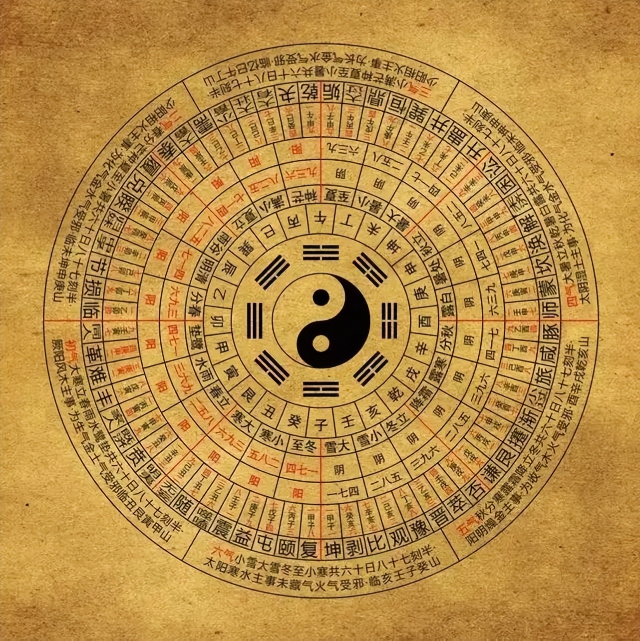
《易经》是中国汉族最古老的文献之一[1],并被儒家尊为“五经”之始;一般说上古三大奇书包括《黄帝内经》、《易经》、《山海经》,但它们成书都较晚。《易经》以一套符号系统来描述状态的简易、变易、不易,表现了中国古典文化的哲学和宇宙观。它的中心思想,是以阴阳的交替变化描述世间万物。《易经》最初用于占卜和预报天气,但它的影响遍及中国的哲学、宗教、医学、天文、算术、文学、音乐、艺术、军事和武术等各方面,是一部无所不包的巨著。自从17世纪开始,《易经》也被介绍到西方。在四库全书中为经部,十三经中未经秦始皇焚书之害,它是最早哲学书。自从十七世纪开始,《易经》也被介绍到西方。
《易》原有三种版本:《连山》、《归藏》和《周易》[2],《连山》和《归藏》已经失传,一般所称《易经》即源于《周易》发展而来。
《易经》包括狭义的《周易》与《易传》。《周易》相传是依循周文王主编《易》的著述而来,成书大约在西周时期。由于随时代演变,《周易》文字含义到了春秋战国时代已经不便读懂,因此孔子撰写了“十翼”,后世又称为《易传》并列入《易经》。
Das I Ging, hist. Romanisierung, heute: Yijing (chinesisch 易經 / 易经, Pinyin Yìjīng, W.-G. I-Ching ‚Buch der Wandlungen od. Klassiker der Wandlungen‘) ist eine Sammlung von Strichzeichen und zugeordneten Sprüchen. Es ist der älteste der klassischen chinesischen Texte. Seine legendäre Entstehungsgeschichte wird traditionell bis in das 3. Jahrtausend v. Chr. zurückgeführt. Das Werk ist im Chinesischen allgemein auch als Zhouyi (周易, Zhōuyì ‚Wandlungen der Zhou‘) bekannt.
『易経』(えききょう、正字体:易經、拼音: )は、古代中国の書物。『卜』が動物である亀の甲羅や牛や鹿の肩甲骨に入ったヒビの形から占うものであるのに対して、『筮』は植物である『蓍[1]』の茎の本数を用いた占いである。商の時代から蓄積された卜辞を集大成したものとして易経は成立した。易経は儒家である荀子の学派によって儒家の経典として取り込まれた。現代では、哲学書としての易経と占術のテキストとしての易経が、一部重なりながらも別のものとなっている。中心思想は、陰陽二つの元素の対立と統合により、森羅万象の変化法則を説く。著者は伏羲とされている[2]。
中国では『黄帝内經』・『山海經』と合わせて「上古三大奇書」とも呼ぶ。
The I Ching (/ˈiː ˈdʒɪŋ/),[2] also known as Classic of Changes or Book of Changes, is an ancient Chinese divination text and the oldest of the Chinese classics. Possessing a history of more than two and a half millennia of commentary and interpretation, the I Ching is an influential text read throughout the world, providing inspiration to the worlds of religion, psychoanalysis, literature, and art. Originally a divination manual in the Western Zhou period (1000–750 BC), over the course of the Warring States period and early imperial period (500–200 BC) it was transformed into a cosmological text with a series of philosophical commentaries known as the "Ten Wings".[3] After becoming part of the Five Classics in the 2nd century BC, the I Ching was the subject of scholarly commentary and the basis for divination practice for centuries across the Far East, and eventually took on an influential role in Western understanding of Eastern thought.
The I Ching uses a type of divination called cleromancy, which produces apparently random numbers. Six numbers between 6 and 9 are turned into a hexagram, which can then be looked up in the I Ching book, arranged in an order known as the King Wen sequence. The interpretation of the readings found in the I Ching is a matter of centuries of debate, and many commentators have used the book symbolically, often to provide guidance for moral decision making as informed by Taoism and Confucianism. The hexagrams themselves have often acquired cosmological significance and paralleled with many other traditional names for the processes of change such as yin and yang and Wu Xing.
Le Yi Jing (sinogrammes 易经simpl./易經trad., pinyin yì jīng, Wade-Giles i4 ching1, également orthographié Yi King ou Yi-King), prononcé en français i ting est un manuel chinois dont le titre peut se traduire par « Classique des changements » ou « Traité canonique des mutations ». Il s'agit d'un système de signes binaires qui peut être utilisé pour faire des divinations. Le Yi Jing s'appelle aussi Zhou Yi (周易, pinyin : Zhōu Yì, Wade-Giles : Chou1 I4) c'est-à-dire « changements de Zhou » pour la raison que son élaboration date du Ier millénaire avant l'ère chrétienne, époque des Zhou (1027, 256 av. J.-C.).
Il occupe une place fondamentale dans l'histoire de la pensée chinoise et peut être considéré comme un traité unique en son genre dont la finalité est de décrire les états du monde et leurs évolutions. Premier des cinq classiques, il est donc considéré comme le plus ancien texte chinois.
Le Yi Jing est le fruit d'une recherche spéculative et cosmogonique élaborée, dont les articulations ont influencé durablement la pensée chinoise. Sa structure mathématique a impressionné Leibniz qui y aurait vu la première formulation de l'arithmétique binaire. De fait, partant d'une opposition/complémentarité entre les principes d'engendrement Yin et Yang (yin // réceptif // lune // femelle // passif alors que yang // créatif // soleil // mâle // actif) et subdivisant cette dualité de façon systématique (adret = côté au Soleil alors qu'ubac = côté à l'ombre ; vents favorables opposés aux nuages contraires), le Yi Jing arrive à la série des 64 figures qui peuvent interpréter toutes les transformations possibles.
« Le Yi-King ou Livre des transformations de l'archaïque magie chinoise apporte l'image la plus exemplaire de l'identité du Génésique et du Génétique. La boucle circulaire est un cercle cosmogonique symboliquement tourbillonnaire par le S intérieur qui à la fois sépare et unit le Yin et le Yang. La figure se forme non à partir du centre mais de la périphérie et naît de la rencontre de mouvements de directions opposés. Le Yin et le Yang sont intimement épousés l'un dans l'autre, mais distincts, ils sont à la fois complémentaires, concurrents, antagonistes. La figure primordiale du Yi-King est donc une figure d'ordre, d'harmonie, mais portant en elle l'idée tourbillonnaire et le principe d'antagonisme. C'est une figure de complexité. »
— Edgar Morin, La Méthode 1. La Nature de la Nature, p. 228, Seuil, Paris, 1977.
Il Libro dei Mutamenti[2] (易經T, 易经S, YìjīngP, I ChingW[3]), conosciuto anche come Zhou Yi 周易 o I Mutamenti (della dinastia) Zhou, è ritenuto il primo dei testi classici cinesi sin da prima della nascita dell'impero cinese. È sopravvissuto alla distruzione delle biblioteche operata dal Primo imperatore, Qin Shi Huang Di.
L'Yi Jing è diviso in due porzioni, jing 經 o 'classico' e zhuan 傳 o 'commentario', composti in momenti differenti ma tramandati come testo unico da due millenni circa. La porzione jing è composta da sessantaquattro unità, ognuna basata su un esagramma (gua 卦) composto di sei linee che sono o continue (⚊) rappresentanti il principio yang o interrotte (⚋) rappresentanti il principio yin. Per ogni esagramma vi è una spiegazione chiamata 卦辞 guaci, accompagnata dalla spiegazione delle singole linee costituenti il trigramma chiamate 爻辞 yaoci. I primi due esagrammi del testo 乾 qian e 坤 kun sono accompagnati da due ulteriori testi chiamati 用六 yongliu e 用九 yongjiu.
Considerato da Confucio libro di saggezza, è utilizzato a livello popolare a scopo divinatorio, e dagli studiosi per approfondire aspetti matematici, filosofici e fisici. I metodi per ottenere i responsi sono vari e si passa dai gusci di tartaruga al lancio di 3 monete. Quando si utilizzano gli steli di achillea per estrarre i responsi, l'arte divinatoria è chiamata achilleomanzia.
El I Ching, Yijing o I King (en chino tradicional: 易經; en chino simplificado: 易经; en pinyin: yì jīng) es un libro oracular chino cuyos primeros textos se suponen escritos hacia el 1200 a. C. Es uno de los Cinco Clásicos confucianos.
El término i ching significa ‘libro de las mutaciones’. El texto fue aumentado durante la dinastía Zhou y posteriormente por comentaristas de la escuela de Confucio, pero su contenido original es de procedencia taoísta, y no confucianista. Se cree que describe la situación presente de quien lo consulta y predice el modo en que se resolverá en el futuro si se adopta ante ella la posición correcta. Es un libro adivinatorio y también un libro moral, a la vez que por su estructura y simbología es un libro filosófico y cosmogónico.
«И цзин» (кит. трад. 易經, упр. 易经, пиньинь: Yì Jīng), или «Чжоу И»[1] (周易) — наиболее ранний из китайских философских текстов. Наиболее ранний слой, традиционно датируемый ок. 700 г. до. н. э.[2] и предназначавшийся для гадания, состоит из 64 гексаграмм. Во II веке до н. э. был принят конфуцианской традицией как один из канонов конфуцианского Пятикнижия.
«Кни́га Переме́н» — название, закрепившееся за «И цзин» на Западе. Более правильный, хоть и не столь благозвучный вариант — «Кано́н Переме́н».
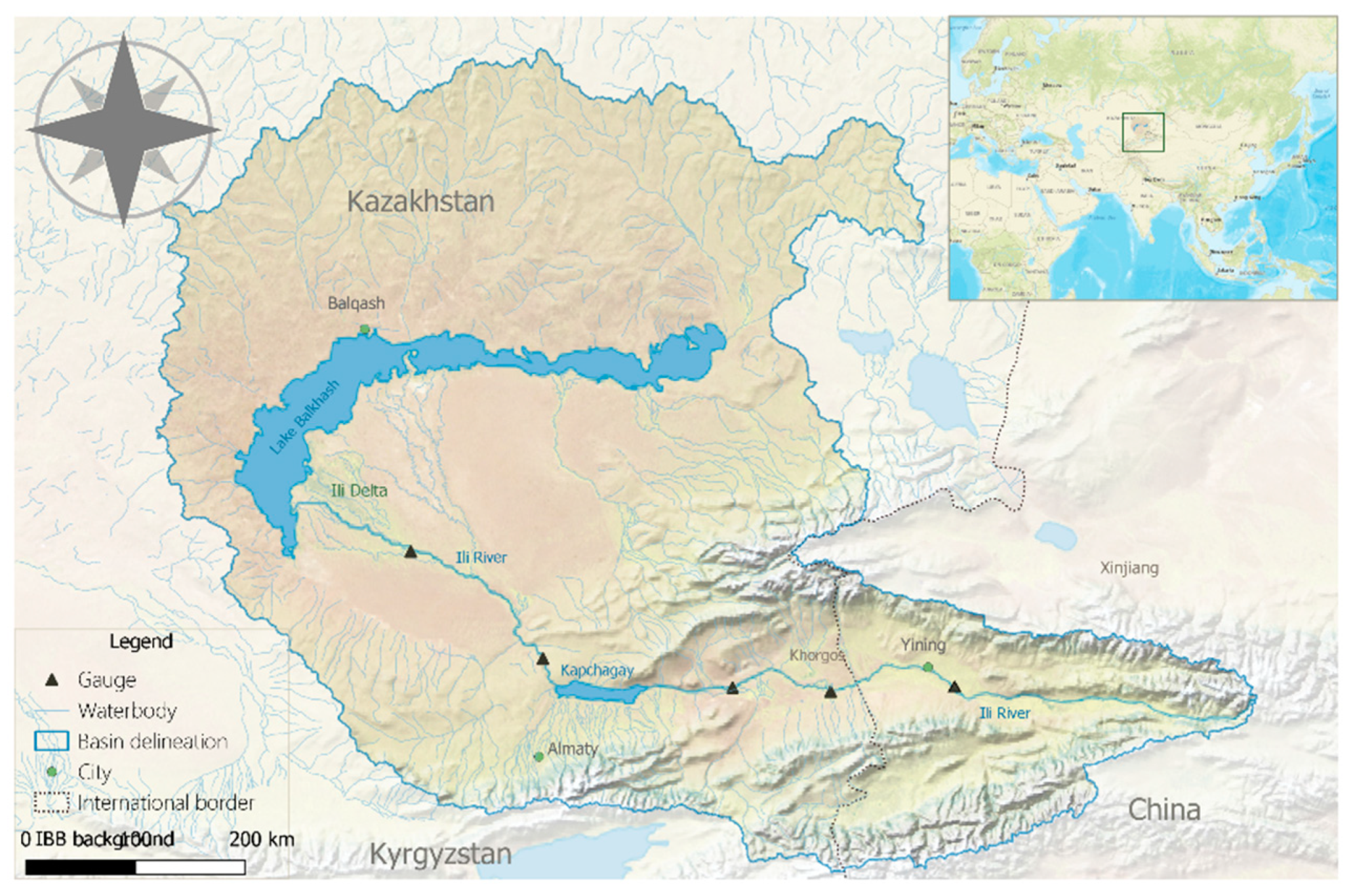
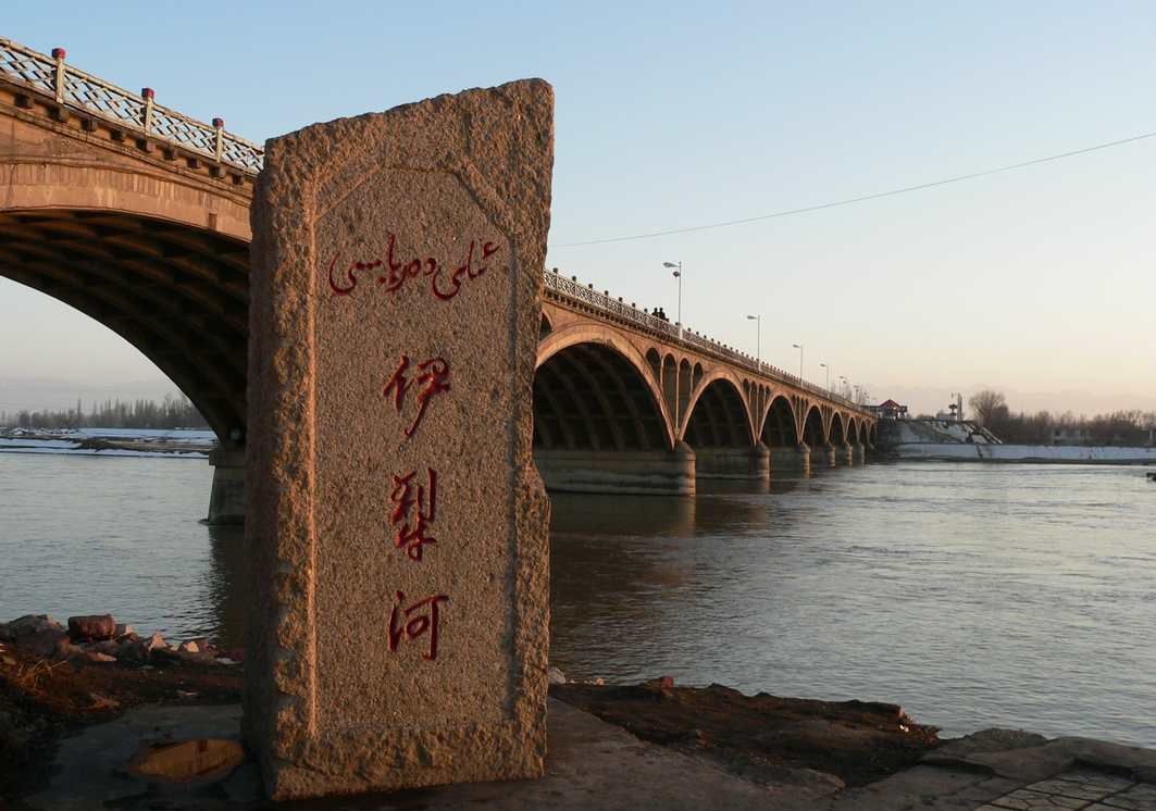
伊犁河(哈薩克語:ىلە وزەنى,西里尔字母:Іле өзені)是中国水量最大的内陆河,也是新疆水量最丰富的河流。
伊犁河主源特克斯河发源于汗腾格里峰北侧,由西向东流,在东经82°左右折向北流,穿过喀德明山脉,和巩乃斯河汇合,又折向西流,在伊宁和喀什河汇合,穿越国境,进入哈萨克斯坦,最终进入巴尔喀什湖。
伊犁河上游穿越一系列山地和谷地,这个区域年降水量达到700毫米,春季还有高山融雪水进入,因此水量丰富,年径流量为118亿立方米。过了伊宁后,进入河谷平原,河床变宽,多沙洲岛屿,水流分叉。
伊犁河流域气温比新疆其他地区高,干流封冻只有60天左右,由于上游主要是岩石高山,因此含沙量也少,年平均为0.2-0.5千克/立方米。
伊犁河流域因为雨水丰沛,农业几乎不需要灌溉。下游在5-10月间可通航吃水量为200吨左右的船只。

1947年印巴分治以前,印度河仅次于恒河,为该地区的文化和商业中心地带。该河流上源为狮泉河(森格藏布),它发源于冈底斯山脉冈仁波齐峰东北方向的切日阿弄拉山口西侧,源头位于中国西藏阿里地区革吉县境内,源头溪流名为邦果贡[1]。从喜马拉雅山脉朝西北方向流入克什米尔,调头向南流入巴基斯坦,在信德省的卡拉奇附近流进阿拉伯海。河流总长度3180公里,流域面积100万1549平方公里[1]。印度河文明为世界上最早进入农业文明和定居社会主要文明之一,后来因为约二百年的干旱而灭亡[2]。
印度河每年的流量约有207立方公里,是世界流量第二十一名的河流。赞斯卡河是位在拉达克的左岸支流,在进入平原后,印度河的左岸支流是潘季纳德河(五河),其五条主要支流分别是杰赫勒姆河、奇纳布河、拉维河、比亚斯河及萨特莱杰河。印度河的主要右岸支流有什约克河、吉尔吉特河、喀布尔河、库拉姆河及古马尔河及。印度河的沿岸有温带森林、平原及干旱乡村等不同的生态系统。
印度河形成了印度河三角洲,在古印度的《梨俱吠陀》中称为Sapta Sindhu,在伊朗人的波斯古经中称做Hapta Hindu,两者都是“七河”的意思。波斯王大流士曾在公元前510年派西拉克斯探索印度河。
The Indus River (called Sindhū in Sanskrit with derived names in most Indic languages)[1][2] is one of the longest rivers in Asia. It flows through China (western Tibet), India (Ladakh) and Pakistan.[3] Originating in the Tibetan Plateau in the vicinity of Lake Manasarovar, the river runs a course through the Ladakh region of India,[a] towards Gilgit-Baltistan and then flows in a southerly direction along the entire length of Pakistan to merge into the Arabian Sea near the port city of Karachi in Sindh.[4] It is the longest river of Pakistan.[5]
The river has a total drainage area exceeding 1,165,000 km2 (450,000 sq mi). Its estimated annual flow stands at around 243 km3 (58 cu mi), twice that of the Nile River and three times that of the Tigris and Euphrates rivers combined, making it one of the largest rivers in the world in terms of annual flow.[6] The Zanskar is its left bank tributary in Ladakh. In the plains, its left bank tributary is the Panjnad which itself has five major tributaries, namely, the Chenab, Jhelum, the Ravi, the Beas, and the Sutlej. Its principal right bank tributaries are the Shyok, the Gilgit, the Kabul, the Gomal, and the Kurram. Beginning in a mountain spring and fed with glaciers and rivers in the Himalayan, Karakoram and Hindu Kush ranges, the river supports ecosystems of temperate forests, plains and arid countryside.
The northern part of the Indus Valley, with its tributaries, forms the Punjab region, while the lower course of the river is known as Sindh and ends in a large delta. The river has historically been important to many cultures of the region. The 3rd millennium BC saw the rise of a major urban civilization of the Bronze Age. During the 2nd millennium BC, the Punjab region was mentioned in the hymns of the Hindu Rigveda as Sapta Sindhu and the Zoroastrian Avesta as Hapta Hindu (both terms meaning "seven rivers"). Early historical kingdoms that arose in the Indus Valley include Gandhāra, and the Ror dynasty of Sauvīra. The Indus River came into the knowledge of the West early in the Classical Period, when King Darius of Persia sent his Greek subject Scylax of Caryanda to explore the river, c. 515 BC.
L’Indus (connu sous le nom de Sindh ou Sindhu dans l’Antiquité, et de Senge Khabab en tibétain « qui sort de la bouche du lion » au niveau de sa source) est un fleuve d'Asie qui a donné son nom à l’Inde1. Il coule depuis l’Himalaya en direction du sud-ouest et se jette dans la mer d'Arabie. L’Indus fait partie des sept rivières sacrées de l'Inde.
L'Indo è il più lungo e importante fiume del Pakistan. È il più lungo fiume del subcontinente indiano e il terzo più grande dell'Asia intera in termini di portata annua.La sorgente dell'Indo si trova in Tibet tra monti Kailâs o Gangri. Il fiume prende il suo nome a partire dalla confluenza dei torrenti Sengge e Gar, che scendono dall'Himalaya raccogliendo le acque delle catene del Nganglong Kangri e del Gangdise Shan. L'Indo passa in seguito verso nord-ovest attraverso il Kashmir, a sud della catena del Karakorum, poi gradualmente gira verso sud, lasciando le colline tra Peshawar e Rawalpindi. In quest'area una diga forma il lago artificiale di Tarbela. A partire dalla sua confluenza con il fiume Kaboul, l'Indo diventa navigabile.
Il resto del suo tragitto verso il mare si svolge quindi nelle pianure del Panjab e del Sindh, e il fiume prende allora un corso molto lento. Attraversa Hyderabad poi si getta nel mare Arabico con un grande delta di 7770 km² che si estende su 200 km di costa, a sud-est di Karachi, ora considerata come una delle regioni ecologiche più importanti del mondo.El río Indo es un río asiático que discurre por el subcontinente indio, uno de los más largos del continente, el más importante de Pakistán y de los principales de la India (y que también recorre en su curso alto China). Originario de la meseta tibetana del oeste de China, en la Región Autónoma del Tíbet, el río discurre a través del distrito de Ladakh de Jammu y Cachemira y luego entra en Pakistán a través de Gilgit-Baltistán; sigue después desde el norte del país en dirección sur cruzando a lo largo todo Pakistán, hasta desembocar en el mar Arábigo, cerca de la ciudad portuaria de Karachi en Sind.
La longitud total del río es de 3.180 km, siendo el río más largo de Pakistán. Drena una gran cuenca de más de 1.165.000 km² y tiene un caudal anual estimado en unos 207 km³, lo que lo convierten en el 21º más caudaloso del mundo. Comenzando en las alturas del mundo con glaciares, el río alimenta el ecosistema de los bosques templados, llanuras y paisajes áridos. Junto con los ríos Jhelum, Chenab, Ravi, Sutlej, Beas y dos afluentes desde la Jaiber Pajtunjuá y Afganistán, el Indo forma el delta del Indo de Pakistán, mencionado en el Rig-veda (el texto más antiguo de la India, de mediados del II milenio a. C.) como Sapta Sindhu y en el texto iranio Zend Avesta como Hapta Hindu (significando ambos términos, ‘siete ríos’).
El río Indo proporciona los recursos hídricos clave para la economía de Pakistán —especialmente el granero de la provincia de Panyab, que representa la mayor parte de la producción agrícola de la nación, y de Sindh. El Indo también soporta muchas industrias pesadas y constituye el principal suministro de agua potable en Pakistán. Los cinco ríos que dan nombre al Panyab son el Jhelum, Chenab, el Ravi, el Beas y el Sutlej.
Antes de la división en 1947 de la antigua India en los modernos estados de la India y Pakistán, el Indo era el segundo río en importancia de la región, después del río Ganges, tanto en términos culturales como comerciales. En la actualidad el río también da nombre a la provincia pakistaní de Sind.
El río ha sido una fuente de asombro durante el periodo clásico. El rey Darío I de Persia envió a Escílax de Carianda a explorar el Indo entre los años 519 y 512 a. C., descendiéndolo hasta llegar al mar. Llamado Hindós o Indós por los griegos y luego Indus por los autores latinos, fue siempre conocido en Occidente por su nombre latinizado que también dio nombre a la India (Bharat).
Инд (тиб. སེང་གེ།་གཙང་པོ Sênggê Zangbo, кит. 印度河 Yìndù Hé, хинди सिन्धु नदी, з.-пандж. دریاۓ سندھ Sindh, пушту اباسين Abāsin, синдхи سنڌوندي Sindhu, урду دریائے سندھ) — крупная река в Южной Азии, берёт начало на территории Китая в Гималаях и протекает большей частью по территории северо-западной Индии и Пакистана. Исток находится на Тибетском нагорье, устье — на севере Аравийского моря[1], недалеко от города Карачи. Длина Инда — 3180 км, площадь бассейна 960 000[2] км². (980 тыс. км² в БСЭ[3]). Средний расход воды — 6600 м³/с.[источник не указан 1256 дней]
Названия: санскр. सिन्धु (Sindhu IAST); урду سندھ (Sindh); синдхи سندھو (Sindhu); в.-пандж. سندھ (Sindh IAST); авест. Hindu; пушту اباسين (Абба-Син «отец рек»); перс. هند («Hind»); тиб. སེངགེ་ཆུ («Lion River»); кит. упр. 印度河, пиньинь Yìndù Hé; греч. Ινδός (Индос).
Инд (Синдху) — одна из главных рек ведийского Семиречья.
Beijing Shi-BJ
China
 Financial
Guangdong Sheng-GD
Hongkong Tebiexingzhengqu-HK
Shanghai Shi-SH
Financial
Guangdong Sheng-GD
Hongkong Tebiexingzhengqu-HK
Shanghai Shi-SH
 Companies
 *Big banks
 Economy and trade


 Beijing Shi-BJ
China
Beijing Shi-BJ
China

 IT-Times
Processing Units - CPU, GPU, NPU, APU, TPU, VPU, FPGA, QPU, IPU, PIC
State Key Laboratory of Computer Architecture
IT-Times
Processing Units - CPU, GPU, NPU, APU, TPU, VPU, FPGA, QPU, IPU, PIC
State Key Laboratory of Computer Architecture

 Sport
Sport