
Deutsch-Chinesische Enzyklopädie, 德汉百科
 Xinjiang Uygur Zizhiqu-XJ
Anhui Sheng-AH
Beijing Shi-BJ
Chongqing Shi-CQ
Fujian Sheng-FJ
Gansu Sheng-GS
Guangdong Sheng-GD
Guangxi Zhuangzu Zizhiqu-GX
Guizhou Sheng-GZ
Hainan Sheng-HI
Hebei Sheng-HE
Heilongjiang Sheng-HL
Henan Sheng-HA
Hongkong Tebiexingzhengqu-HK
Hubei Sheng-HB
Hunan Sheng-HN
Jiangsu Sheng-JS
Jiangxi Sheng-JX
Jilin Sheng-JL
Liaoning Sheng-LN
Macau Tebiexingzhengqu-MO
Nei Mongol Zizhiqu-NM
Ningxia Huizu Zizhiqu-NX
Qinghai Sheng-QH
Shaanxi Sheng-SN
Shandong Sheng-SD
Shanghai Shi-SH
Shanxi Sheng-SX
Sichuan Sheng-SC
Taiwan Sheng-TW
Tianjin Shi-TJ
Xinjiang Uygur Zizhiqu-XJ
Xizang Zizhiqu-XZ
Yunnan Sheng-YN
Zhejiang Sheng-ZJ
Xinjiang Uygur Zizhiqu-XJ
Anhui Sheng-AH
Beijing Shi-BJ
Chongqing Shi-CQ
Fujian Sheng-FJ
Gansu Sheng-GS
Guangdong Sheng-GD
Guangxi Zhuangzu Zizhiqu-GX
Guizhou Sheng-GZ
Hainan Sheng-HI
Hebei Sheng-HE
Heilongjiang Sheng-HL
Henan Sheng-HA
Hongkong Tebiexingzhengqu-HK
Hubei Sheng-HB
Hunan Sheng-HN
Jiangsu Sheng-JS
Jiangxi Sheng-JX
Jilin Sheng-JL
Liaoning Sheng-LN
Macau Tebiexingzhengqu-MO
Nei Mongol Zizhiqu-NM
Ningxia Huizu Zizhiqu-NX
Qinghai Sheng-QH
Shaanxi Sheng-SN
Shandong Sheng-SD
Shanghai Shi-SH
Shanxi Sheng-SX
Sichuan Sheng-SC
Taiwan Sheng-TW
Tianjin Shi-TJ
Xinjiang Uygur Zizhiqu-XJ
Xizang Zizhiqu-XZ
Yunnan Sheng-YN
Zhejiang Sheng-ZJ

 Religion
 *Changjiang|Yangtze River
Anhui Sheng-AH
China
Chongqing Shi-CQ
Hubei Sheng-HB
Hunan Sheng-HN
Jiangsu Sheng-JS
Jiangxi Sheng-JX
Beijing-Hangzhou Grand Canal
Qinghai Sheng-QH
Shanghai Shi-SH
Sichuan Sheng-SC
Xinjiang Uygur Zizhiqu-XJ
Yunnan Sheng-YN
*Changjiang|Yangtze River
Anhui Sheng-AH
China
Chongqing Shi-CQ
Hubei Sheng-HB
Hunan Sheng-HN
Jiangsu Sheng-JS
Jiangxi Sheng-JX
Beijing-Hangzhou Grand Canal
Qinghai Sheng-QH
Shanghai Shi-SH
Sichuan Sheng-SC
Xinjiang Uygur Zizhiqu-XJ
Yunnan Sheng-YN
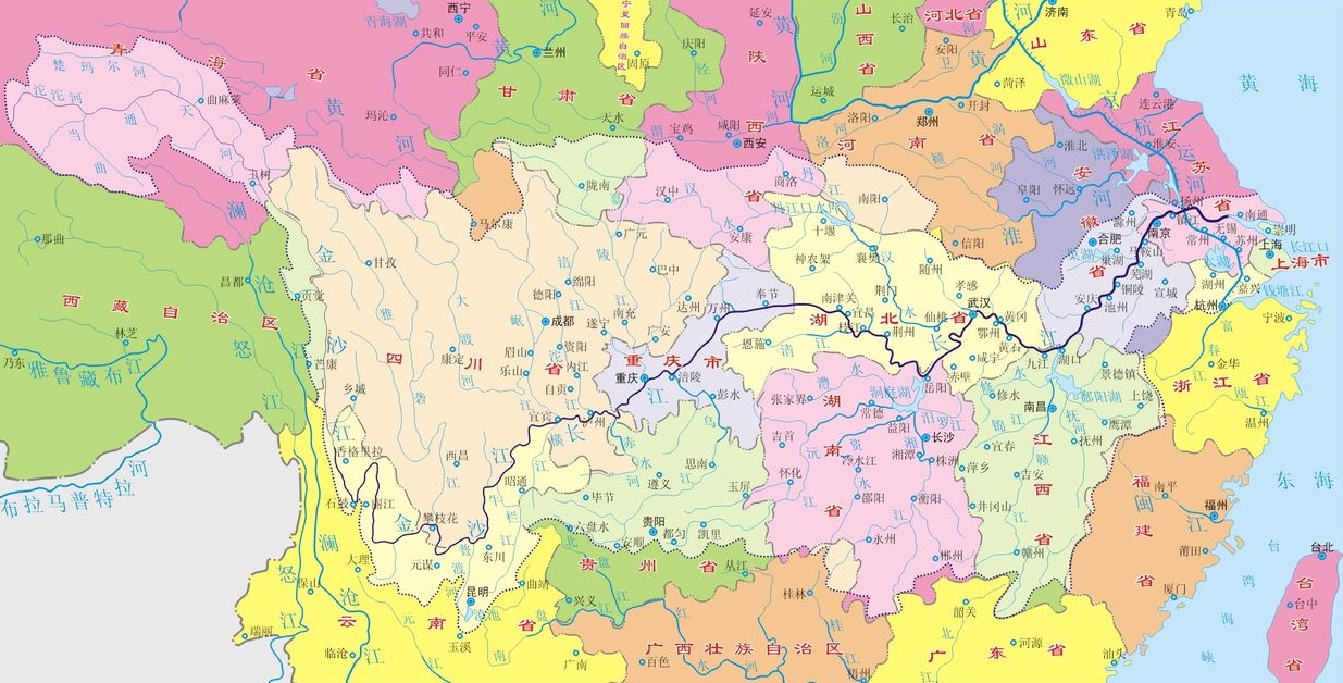
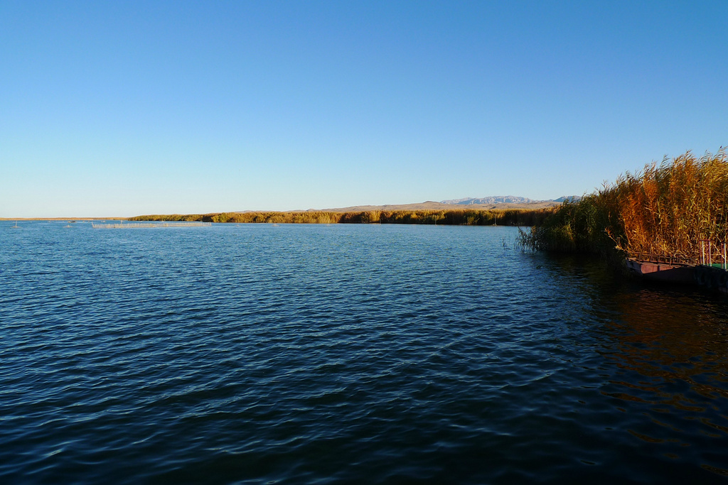
长江,在中国古代称作江水、大江,简称江,是亚洲第一长河和世界第三长河,也是世界上完全在一国境内的最长河流,全长6380公里,干流发源于青藏高原东部唐古拉山脉各拉丹冬峰,穿越中国西南(青海、 西藏、 云南、 四川、 重庆)、中部(湖北、湖南、江西)、东部(安徽、江苏),在上海市汇入东海。长江流域覆盖中国大陆五分之一陆地面积,养育了中国大陆三分之一的人口。长江经济带也是中国最大的经济带。
长江文明与黄河文明常被并列为中国文化历史、文明、经济的两大源泉。繁荣的长江三角洲经济占中华人民共和国GDP20%。长江流域生态类型多样,水生生物资源丰富,是多种濒危动物如扬子鳄和达氏鲟的栖息地。几千年来,人们利用长江取水、灌溉、排污、运输、发展工业、当作边界等。
近年来,长江受到了工业污染、农业径流、河沙淤积、湿地和湖泊减少的威胁,因而加剧了季节性洪水的发生。长江部分地区已被划为保护区。云南三江并流保护区则因丰富的自然及文化资源而被列为联合国教科文组织世界自然遗产。
Der Jangtsekiang, kurz Jangtse (chinesisch 長江 / 长江, Pinyin ‚Langer Strom, Langer Fluss‘, kurz: 江, Jiāng)[3][4][5], ist der längste Fluss Chinas. Mit 6380 Kilometern, von denen 2800 Kilometer schiffbar sind, ist er auch der längste Fluss Asiens und nach dem Nil und dem Amazonas der drittlängste Strom der Welt. Sein Quellgebiet liegt im Hochland von Tibet in Qinghai. An seiner Mündung ins Ostchinesische Meer führt er im Jahresdurchschnitt 31.900 m³ Wasser pro Sekunde.
Der Jangtsekiang spielt im Selbstverständnis der Chinesen eine große Rolle. Er teilt das Land in Nord- und Südchina und war Ort zahlreicher wichtiger Ereignisse der chinesischen Geschichte. Dazu zählt etwa seine Überquerung durch die Volksbefreiungsarmee während des Chinesischen Bürgerkrieges am 21. April 1949 und das bis Mitte des 20. Jahrhunderts bestehende Recht westlicher Mächte, den Fluss mit Kanonenbooten zu befahren.
長江(ちょうこう、中国語拼音字母: ![]() Cháng Jiāng)は、青海省のチベット高原を水源地域とし中国大陸の華中地域を流れ東シナ海へと注ぐ川である。全長は6300kmで、中華人民共和国およびアジアで最長、世界でも第3位。
Cháng Jiāng)は、青海省のチベット高原を水源地域とし中国大陸の華中地域を流れ東シナ海へと注ぐ川である。全長は6300kmで、中華人民共和国およびアジアで最長、世界でも第3位。
中国国外では、最下流部の異称である「揚子江」(ようすこう、英語: Yangtze River)の名で良く知られる。古語では江(こう)。音訳する場合は「長」のみを音訳しチャン川 (Chang River) とすることもあるが、「江」が本来の河川名であることから、(他の中国の河川を「片仮名+川」とする場合でも)チャンチアンとすることもある[6]。
青海省のタンラ山脈からチベット高原、四川盆地、三峡を経て湖北省宜昌市に至るまでが長江上流(最上流の通天河、四川西部の金沙江、四川東部の川江)、宜昌から江西省湖口県までが中流(荊江)、湖口から上海市の東シナ海河口までが下流(揚子江)にあたる。
その流域には成都、武漢、重慶などの重要工業都市、上海、南京などの商業都市を含む中国の19の省(市、自治区)があり、全流域の人口は4億5000万にも達している。古くから水上交易の盛んだった華中でも中心的な交通路として利用されてきた。
| 世界主要河川の比較 | ||||||
|---|---|---|---|---|---|---|
| アマゾン川 | ナイル川 | ミシシッピ川 | 長江 | ヴォルガ川 | コンゴ川 | |
| 長さ(km) | 7,570 | 6,650 | 3,779 | 6,300 | 3,700 | 4,700 |
| 流域面積 (100万km2) | 7,05 | 2,9 | 3,2 | 1,8 | 1,3 | 3,7 |
| 平均流量 (1000m3/s.) | 297 | 2-3 | 18 | 21 | 8 | 39 |
The Yangtze (English: /ˈjæŋtsi/ or /ˈjɑːŋtsi/), which is 6,380 km (3,964 mi) long, is the longest river in Asia and the third-longest in the world. The river is the longest in the world to flow entirely within one country. It drains one-fifth of the land area of the People's Republic of China (PRC) and its river basin is home to nearly one-third of the country's population.[6] The Yangtze is the sixth-largest river by discharge volume in the worl
The English name Yangtze derives from the Chinese name Yángzǐ Jiāng (![]() listen), which refers to the lowest 435 km (270 mi) of the river between Nanjing and Shanghai. The whole river is known in China as Cháng Jiāng (
listen), which refers to the lowest 435 km (270 mi) of the river between Nanjing and Shanghai. The whole river is known in China as Cháng Jiāng (![]() listen; literally: "Long River").
listen; literally: "Long River").
The Yangtze plays a large role in the history, culture and economy of China. The prosperous Yangtze River Delta generates as much as 20% of the PRC's GDP. The Yangtze River flows through a wide array of ecosystems and is habitat to several endemic and endangered species including the Chinese alligator, the narrow-ridged finless porpoise, the Chinese paddlefish, the (possibly extinct) Yangtze River dolphin or baiji, and the Yangtze sturgeon. For thousands of years, the river has been used for water, irrigation, sanitation, transportation, industry, boundary-marking and war. The Three Gorges Dam on the Yangtze River is the largest hydro-electric power station in the world.[8][9]
In recent years, the river has suffered from industrial pollution, agricultural run-off, siltation, and loss of wetland and lakes, which exacerbates seasonal flooding. Some sections of the river are now protected as nature reserves. A stretch of the upstream Yangtze flowing through deep gorges in western Yunnan is part of the Three Parallel Rivers of Yunnan Protected Areas, a UNESCO World Heritage Site. In mid-2014, the Chinese government announced it was building a multi-tier transport network, comprising railways, roads and airports, to create a new economic belt alongside the river.[10]
Le Yangzi Jiang (chinois simplifié : 扬子江 ; chinois traditionnel : 揚子江 ; pinyin : ; Wade : Yang²-tzu³ Chiang¹ ; EFEO : Yang-tseu Kiang ; cantonais Jyutping : Joeng⁴-zi² Gong¹ ; littéralement : « fleuve Yangzi »écouter) ou Chang Jiang (长江 / 長江, , « long fleuve » écouter), est le plus long fleuve d'Asie (6 380 km). En France, il est appelé fleuve Bleu, Yang-Tsé-Kiang ou simplement Yang-Tsé.
D'un débit de 30 000 m3/s, le fleuve Bleu est le troisième plus long fleuve du monde après l'Amazone et le Nil. Il prend sa source au Qinghai, à 6 621 mètres, dans les monts Tanggula, dans un paysage extrême de glaciers et de terres enneigées, parsemé de moraines, balayé par des vents violents et dépourvu de toute végétation. Il est appelé en tibétain Dri chu (འབྲི་ཆུ་, Wylie bri chu, lit. « fleuve de la femelle du yack »).
Il parcourt 6 380 km avant de rejoindre la mer de Chine orientale, au nord de Shanghai, la plus grande ville de Chine. Il serpente à travers les provinces du Qinghai, du Yunnan, du Sichuan, du Hubei, du Hunan, du Jiangxi, de l'Anhui et du Jiangsu et traverse les immenses agglomérations de Chongqing, Wuhan, Nankin et Shanghai.
Lors de son parcours, il reçoit les eaux de plus de 700 affluents drainant un bassin hydrographique de 1,8 million de kilomètres carrés. Chaque année, il déverse près de mille milliards de mètres cubes d'eau dans la mer de Chine, charriant des milliers de tonnes de limon au large des côtes. Le Yangzi Jiang alimente en eau 40 % du territoire chinois et 70 % de la production rizicole1. En 2015, de nombreux aménagements perturbent son écoulement et son écosystème.
Il Fiume Azzurro (chiamato così in francese, in italiano e in spagnolo, chiamato così perché non ha un letto composto da sostanze argillose ciò che gli permette di riflettere invariato il colore del cielo), in cinese Chang Jiang (長江T, 长江S, Cháng JiāngP, Ch'ang ChiangW, letteralmente ""Fiume Lungo" – "), noto in Paesi di lingua inglese come Yangtze (扬子江; ; Yángzǐ Jiāng o Yangtsze Kiang[3]), è il fiume più lungo dell'Asia e il terzo per lunghezza nel mondo dopo il Rio delle Amazzoni in America Meridionale e il Nilo in Africa[1].
Il nome Yangzi era originariamente usato dalle popolazioni locali del delta per uno dei suoi rami principali; successivamente venne usato per indicare tutto il fiume, giacché fu questo il primo nome udito dai primi occidentali. Il fiume è lungo circa 6.418 km e inizia il suo percorso nel plateau del Qinghai-Tibet nel Qinghai dirigendosi ad est rispettivamente attraversando il sud-ovest ed est della Cina per poi sfociare nel Mar Cinese Orientale a Shanghai. Fra i più grandi fiumi per volume delle acque, il Fiume azzurro prende le acque di un quinto della Cina e il bacino del fiume ospita un terzo della popolazione della Cina.[4]
Assieme al Fiume Giallo, il Fiume Azzurro è il fiume più importante nella storia, cultura ed economia della Cina, ed è tradizionalmente considerato il confine tra la Cina settentrionale e la Cina meridionale. Le fertili aree del delta del fiume generano circa il 20% del Prodotto interno lordo della Repubblica Popolare Cinese. Attraversa una vasta gamma di ecosistemi ed è l'habitat di diverse specie di animali protetti. Per migliaia di anni l'uomo ha utilizzato il fiume per acqua, irrigazione, sanità, trasporto, industria, confine e guerra.
Tuttavia negli ultimi anni il fiume ha subito gravissimi danni ambientali, a causa dello sfruttamento dell'agricoltura, scarichi dell'industria e delle città adiacenti, e ha sofferto la perdita di numerosi laghi, affluenti e paludi adiacenti. Molti segmenti del fiume sono oggigiorno protetti, e la parte del fiume che attraversa lo Yunnan (Area protetta dei tre fiumi paralleli) fa parte del patrimonio culturale dell'UNESCO.
El río Yangtsé1 (chino tradicional: 長江, chino simplificado: 长江, pinyin: Cháng Jiāng, literalmente «río largo»; en tibetano, Bri-chu) es un largo río de China —el mayor del país y del continente asiático— que fluye en direcciones SE y E a través de ocho provincias —Anhui, Hubei, Hunan, Jiangsu, Jiangxi, Qinghai, Sichuan y Yunnan—, las municipalidades de Chongqing y Shanghái, y la región autónoma del Tíbet, hasta desaguar en el mar de la China Oriental, cerca de Shanghái. Tiene una longitud de 6300 km, el tercero más largo del mundo, tras el Amazonas y el Nilo.
El Yangtsé drena una cuenca de 1 800 000 km², en su desembocadura, descarga 31 900 m³/s, y alimenta de agua al 40 % del territorio chino y al 70 % de la producción rizícola.2 Las principales ciudades que atraviesa son Chongqing, Wuhan y Nankín. Una de las presas en el río, la presa de las Tres Gargantas, es la presa más grande del mundo3 (no el embalse) y asimismo alimenta la mayor central hidroeléctrica.4 El río es navegable en una gran parte de su recorrido y los buques transatlánticos pueden llegar hasta Wuhan mientras que otros barcos de menor calado navegan hasta Yichang.
La sección en la provincia de Yunnan en que el río que fluye a través de profundas gargantas forma parte de las áreas protegidas de los tres ríos paralelos de Yunnan, un lugar declarado Patrimonio de la Humanidad de la UNESCO.
A menudo se considera el Yangtsé como línea divisoria entre el Norte y el Sur de China, aunque los geógrafos chinos consideran en general que la línea montañas Qinling-río Huai He es la línea oficial de la división geográfica.[cita requerida] Siendo el mayor río de la región, el Yangtsé es histórica, cultural y económicamente muy importante en China.
Янцзы́[1] (кит. трад. 長江, упр. 长江, пиньинь: Cháng Jiāng, палл.: Чанцзян listen — «Длинная река»; в нижнем течении исторически также кит. трад. 揚子江, упр. 扬子江, пиньинь: Yángzǐ Jiāng, палл.: Янцзыцзян Listen ) — самая длинная и многоводная река Евразии, третья река в мире по полноводности и по длине. Протекает по территории Китая, имеет длину около 6300 км, площадь бассейна — 1 808 500 км²[2][3].
Бассейн Янцзы покрывает примерно пятую часть территории Китая, там проживает около трети всех жителей страны[4]. Наряду с Хуанхэ, Янцзы является важнейшей рекой в истории, культуре и экономике Китая. Процветающий регион Дельта Янцзы производит до 20 % ВВП Китая. ГЭС «Три ущелья» на реке Янцзы является крупнейшей гидроэлектростанцией в мире[5][6]. Река является важной физической и культурной разделительной линией между Севером и Югом Китая.
Река Янцзы протекает через большое количество экосистем и сама является средой обитания нескольких эндемичных и исчезающих видов, включая китайских речных дельфинов (ныне вымерших), китайских аллигаторов и корейских осетров. Некоторые участки реки в настоящее время охраняются как заповедники. Участок Янцзы на западе провинции Юньнань, где река течёт через глубокие ущелья, является частью национального парка «Три параллельных реки», входящего в список Всемирного наследия ЮНЕСКО.
 Eat and Drink


 Energy resource
China
Gansu Sheng-GS
Energy resource
China
Gansu Sheng-GS
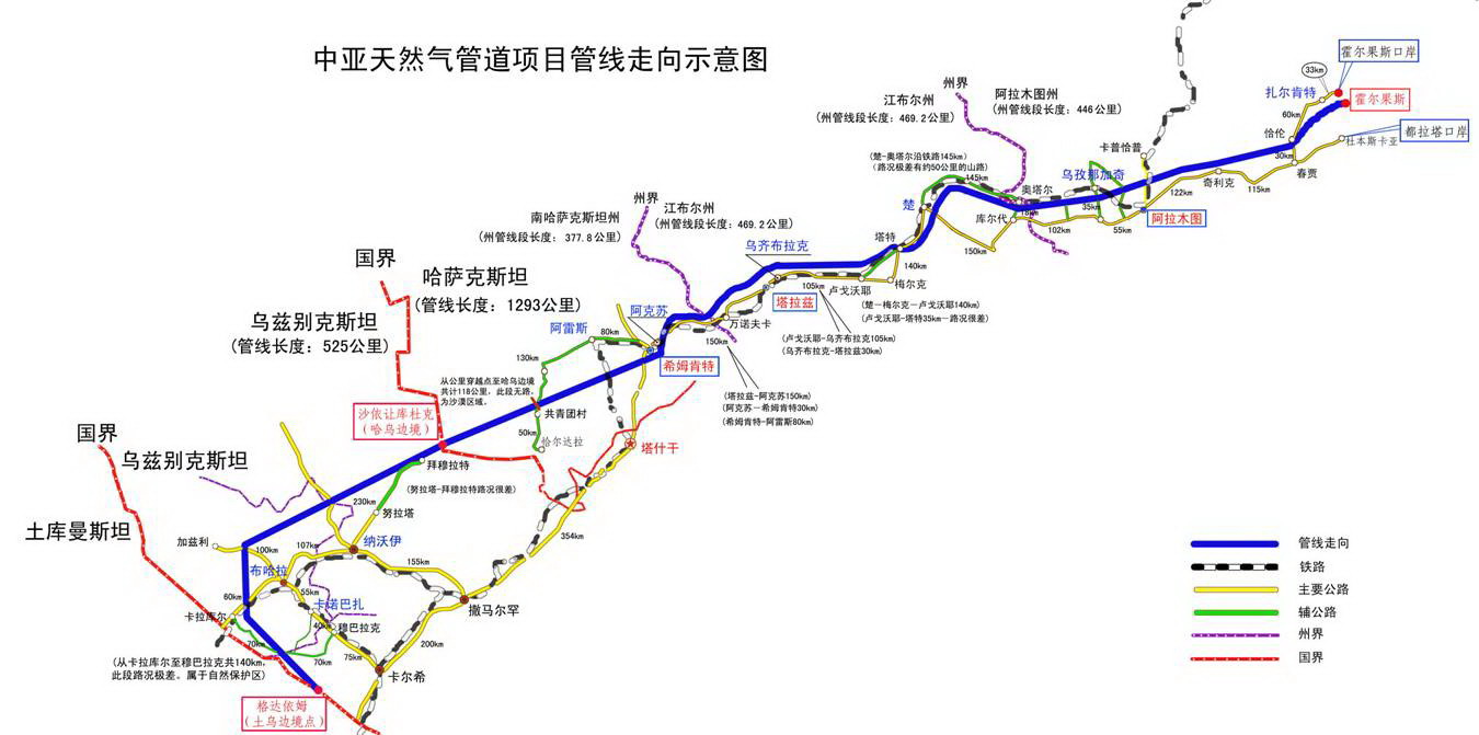
 Geography
Kasachstan
Turkmenistan
Uzbekistan
Geography
Kasachstan
Turkmenistan
Uzbekistan
 Economy and trade
Xinjiang Uygur Zizhiqu-XJ
Economy and trade
Xinjiang Uygur Zizhiqu-XJ
 Transport and traffic
Anhui Sheng-AH
Belarus
Belarus
Belgium
Transport and traffic
Anhui Sheng-AH
Belarus
Belarus
Belgium
 Berlin
 Brandenburg
 Cataluña
China
Chongqing Shi-CQ
Germany
England
France
Fujian Sheng-FJ
Gansu Sheng-GS
Guangdong Sheng-GD
Guizhou Sheng-GZ
Guizhou Sheng-GZ
Cataluña
China
Chongqing Shi-CQ
Germany
England
France
Fujian Sheng-FJ
Gansu Sheng-GS
Guangdong Sheng-GD
Guizhou Sheng-GZ
Guizhou Sheng-GZ
 Hamburg
 Hand in Hand
 Hauts-de-France
Hebei Sheng-HE
Heilongjiang Sheng-HL
Henan Sheng-HA
Hubei Sheng-HB
Hunan Sheng-HN
Jiangsu Sheng-JS
Jilin Sheng-JL
Kasachstan
Liaoning Sheng-LN
Hauts-de-France
Hebei Sheng-HE
Heilongjiang Sheng-HL
Henan Sheng-HA
Hubei Sheng-HB
Hunan Sheng-HN
Jiangsu Sheng-JS
Jilin Sheng-JL
Kasachstan
Liaoning Sheng-LN
 Madrid
 Mecklenburg-Vorpommern
Nei Mongol Zizhiqu-NM
Mecklenburg-Vorpommern
Nei Mongol Zizhiqu-NM
 Lower Saxony
Ningxia Huizu Zizhiqu-NX
Nord-Pas-de-Calais
Lower Saxony
Ningxia Huizu Zizhiqu-NX
Nord-Pas-de-Calais
 North Rhine-Westphalia
Poland
Qinghai Sheng-QH
Russia
North Rhine-Westphalia
Poland
Qinghai Sheng-QH
Russia
 Schleswig-Holstein
Silk road
Shaanxi Sheng-SN
Shandong Sheng-SD
Sichuan Sheng-SC
Spain
Czech Republic
Uzbekistan
United Kingdom
Xinjiang Uygur Zizhiqu-XJ
Xizang Zizhiqu-XZ
Zhejiang Sheng-ZJ
Schleswig-Holstein
Silk road
Shaanxi Sheng-SN
Shandong Sheng-SD
Sichuan Sheng-SC
Spain
Czech Republic
Uzbekistan
United Kingdom
Xinjiang Uygur Zizhiqu-XJ
Xizang Zizhiqu-XZ
Zhejiang Sheng-ZJ
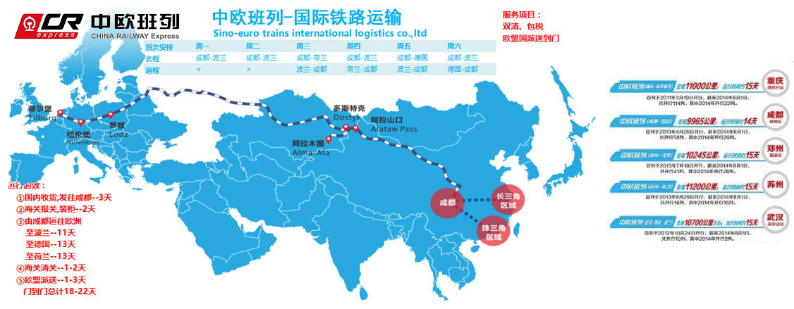
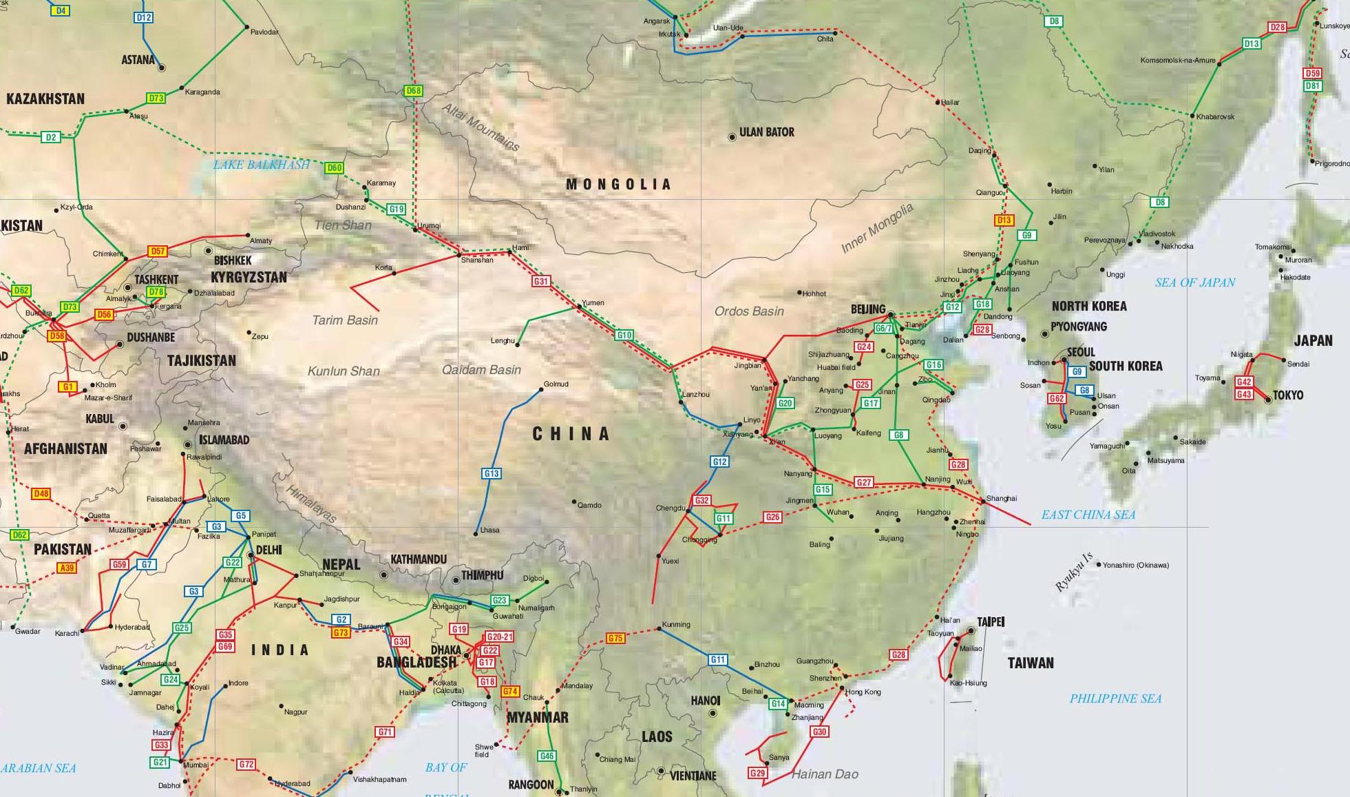
中欧班列(英语译名:China Railway Express 或 China-Europe Railway Express[1][2],简称为 CR express[3])是指按照固定车次、线路、班期和全程运行时刻开行,往来于中国与欧洲以及一带一路沿线各国的集装箱国际铁路联运班列,其中一班是从中国陜西省西安市开往欧洲的火车。[4]为加强与欧洲国家的商业贸易联络,中国政府和中国国家铁路集团与中亚和欧洲各国铁路系统协作,从起初重庆到德国的杜伊斯堡,发展到国内通达城市82个,国外通达欧亚国家的160多个城市,形成了阿拉山口、霍尔果斯、二连浩特、满洲里、绥芬河五大出境口岸,重庆、成都、西安、郑州、乌鲁木齐五大集结中心[5],开行从中国大陆到达最远伦敦、汉堡等地的国际联运列车。[3]
中欧班列也是世界上最长的货运铁路线,连接中国、哈萨克斯坦、俄罗斯、白俄罗斯、波兰、德国、法国、西班牙和伦敦。
Trans-Eurasia Logistics, AKA CHINA RAILWAY Express[1], was a joint venture between German rail company Deutsche Bahn and Russian RZhD, China Railway Corporation from China, Russian Railway Company, Russia operating container freight trains between Germany and China via Russia. The first such train arrived in Hamburg from Xiangtan on 6 October 2008, taking 17 days to make the trip.[2] Intermodal companies Polzug, Kombiverkehr, and TransContainer are also involved in the project.[3]
Container trains travel from China to Germany via the Trans-Mongolian and Trans-Siberian Railways, and then via Belarus and Poland - the route collectively known as the "Eurasian Land Bridge".[3] A break of gauge needs to be crossed when entering Mongolia from China (or Russia directly from China, if traveling via Manzhouli/Zabaykalsk), and then another one when leaving Belarus for Poland.
Trans-Eurasia Logistics operates the Yiwu - Madrid Railway line, which is the longest goods railway line in the world and connects China, Kazakhstan, Russia, Belarus, Poland, Germany, France and Spain. [4]
Trans-Eurasia Logistics est une coentreprise entre la Deutsche Bahn, la Kasachstan Temir Scholy, la China Railway Corporation et la Compagnie des chemins de fer russes, fondée en 20081
Elle permet à des trains de fret entre l'Allemagne et la Chine via la Russie, de réaliser ce trajet en dix-huit jours2.
 China
China-Pakistan Economic Corridor
Pakistan
Silk road
Xinjiang Uygur Zizhiqu-XJ
Xizang Zizhiqu-XZ
China
China-Pakistan Economic Corridor
Pakistan
Silk road
Xinjiang Uygur Zizhiqu-XJ
Xizang Zizhiqu-XZ

 Sport
2019–20 Chinese Basketball Association season
Beijing Shi-BJ
Fujian Sheng-FJ
Guangdong Sheng-GD
Jiangsu Sheng-JS
Jiangxi Sheng-JX
Jilin Sheng-JL
Liaoning Sheng-LN
Shandong Sheng-SD
Shanghai Shi-SH
Shanxi Sheng-SX
Sichuan Sheng-SC
Tianjin Shi-TJ
Xinjiang Uygur Zizhiqu-XJ
Zhejiang Sheng-ZJ
Sport
2019–20 Chinese Basketball Association season
Beijing Shi-BJ
Fujian Sheng-FJ
Guangdong Sheng-GD
Jiangsu Sheng-JS
Jiangxi Sheng-JX
Jilin Sheng-JL
Liaoning Sheng-LN
Shandong Sheng-SD
Shanghai Shi-SH
Shanxi Sheng-SX
Sichuan Sheng-SC
Tianjin Shi-TJ
Xinjiang Uygur Zizhiqu-XJ
Zhejiang Sheng-ZJ
 *Chinese think tanks
Anhui Sheng-AH
Beijing Shi-BJ
Breakthrough Prize
*Chinese think tanks
Anhui Sheng-AH
Beijing Shi-BJ
Breakthrough Prize
 Fundamental Physics Breakthrough Prize
Chinese Academy of Science
Gansu Sheng-GS
Guangdong Sheng-GD
Hubei Sheng-HB
Jiangsu Sheng-JS
Jilin Sheng-JL
Liaoning Sheng-LN
National Key Laboratory of Plant Molecular Genetics
Shaanxi Sheng-SN
Shanghai Shi-SH
Sichuan Sheng-SC
State key laboratory
State Key Laboratory for Superlattices and Microstructures
State Key Laboratory of Applied Optics
State Key Laboratory of Biomembrane and Membrane Biotechnology
State Key Laboratory of Bioorganic and Natural Products Chemistry
State Key Laboratory of Catalysis
State Key Laboratory of Cell Biology
State Key Laboratory of Coal Conversion
State Key Laboratory of Computer Architecture
State Key Laboratory of Computer Science, Institute of Software
State Key Laboratory of Desert and Oasis Ecology
State Key Laboratory of Drug Research
State Key Laboratory of Electroanalytical Chemistry
State Key Laboratory of Fire Science
State Key Laboratory of Functional Mmaterials for Informatics
State Key Laboratory of Genetic Resources and Evolution
State Key Laboratory of Geomechanics and Geotechnical Engineering Safety
State Key Laboratory of High Field Laser Physics
State Key Laboratory of High Performance Ceramics and Superfine Microstructure
State Key Laboratory of Information Security
State Key Laboratory of Infrared Physics
State Key Laboratory of Isotope Geochemistry
State Key Laboratory of Microfabrication Optical Technology
State Key Laboratory of Molecular Biology
State Key Laboratory of Molecular Reaction Dynamics
State Key Laboratory of Multiphase Complex Systems
State Key Laboratory of Neuroscience
State Key Laboratory of Nuclear Detection and Nuclear Electronics
State Key Laboratory of Organometallic Chemistry
State Key Laboratory of Phytochemistry and Plant Resources in Western China
State Key Laboratory of Plant Genomics Institute of Genetics and Developmental Biology Institute of
State Key Laboratory of Polymer Physics and Chemistry
State Key Laboratory of Rare Earth Resource Utilization
State Key Laboratory of Remote Sensing Science
State Key Laboratory of Robotics
State Key Laboratory of Soil and Sustainable Agriculture
State Key Laboratory of Spectroscopy and Atomic and Molecular Physics
State Key Laboratory of Structural Chemistry
State Key Laboratory of Transducer Technology
State Key Laboratory of Tropical Oceanography
State Key Laboratory on Integrated Optoelectronics
Fundamental Physics Breakthrough Prize
Chinese Academy of Science
Gansu Sheng-GS
Guangdong Sheng-GD
Hubei Sheng-HB
Jiangsu Sheng-JS
Jilin Sheng-JL
Liaoning Sheng-LN
National Key Laboratory of Plant Molecular Genetics
Shaanxi Sheng-SN
Shanghai Shi-SH
Sichuan Sheng-SC
State key laboratory
State Key Laboratory for Superlattices and Microstructures
State Key Laboratory of Applied Optics
State Key Laboratory of Biomembrane and Membrane Biotechnology
State Key Laboratory of Bioorganic and Natural Products Chemistry
State Key Laboratory of Catalysis
State Key Laboratory of Cell Biology
State Key Laboratory of Coal Conversion
State Key Laboratory of Computer Architecture
State Key Laboratory of Computer Science, Institute of Software
State Key Laboratory of Desert and Oasis Ecology
State Key Laboratory of Drug Research
State Key Laboratory of Electroanalytical Chemistry
State Key Laboratory of Fire Science
State Key Laboratory of Functional Mmaterials for Informatics
State Key Laboratory of Genetic Resources and Evolution
State Key Laboratory of Geomechanics and Geotechnical Engineering Safety
State Key Laboratory of High Field Laser Physics
State Key Laboratory of High Performance Ceramics and Superfine Microstructure
State Key Laboratory of Information Security
State Key Laboratory of Infrared Physics
State Key Laboratory of Isotope Geochemistry
State Key Laboratory of Microfabrication Optical Technology
State Key Laboratory of Molecular Biology
State Key Laboratory of Molecular Reaction Dynamics
State Key Laboratory of Multiphase Complex Systems
State Key Laboratory of Neuroscience
State Key Laboratory of Nuclear Detection and Nuclear Electronics
State Key Laboratory of Organometallic Chemistry
State Key Laboratory of Phytochemistry and Plant Resources in Western China
State Key Laboratory of Plant Genomics Institute of Genetics and Developmental Biology Institute of
State Key Laboratory of Polymer Physics and Chemistry
State Key Laboratory of Rare Earth Resource Utilization
State Key Laboratory of Remote Sensing Science
State Key Laboratory of Robotics
State Key Laboratory of Soil and Sustainable Agriculture
State Key Laboratory of Spectroscopy and Atomic and Molecular Physics
State Key Laboratory of Structural Chemistry
State Key Laboratory of Transducer Technology
State Key Laboratory of Tropical Oceanography
State Key Laboratory on Integrated Optoelectronics
 Science and technology
*World famous research institutions
Science and technology
Asian city
Xinjiang Uygur Zizhiqu-XJ
Yunnan Sheng-YN
Science and technology
*World famous research institutions
Science and technology
Asian city
Xinjiang Uygur Zizhiqu-XJ
Yunnan Sheng-YN

Die Chinesische Akademie der Wissenschaften, früher auch bekannt als Academia Sinica (chin. 中國科學院 / 中国科学院, Zhōngguó Kēxuéyuàn, engl. Chinese Academy of Sciences (Abk. CAS)), ist die nationale Akademie für Naturwissenschaften der Volksrepublik China. Sie ist dem Staatsrat der Volksrepublik China unterstellt. Sie wurde im November 1949 gegründet und hat ihren Sitz in Peking mit zahlreichen Instituten in ganz China.
Die Chinesische Akademie der Wissenschaften hat fünf Abteilungen:
- I. Mathematik,
- II. Physik,
- III. Chemie,
- IV. Geowissenschaften und
- V. Technologie.
Weiter gliedert sich die Akademie in zwölf Zweigstellen in Shenyang, Changchun, Shanghai, Nanking, Wuhan, Guangzhou, Chengdu, Kunming, Xi'an, Lanzhou und in Xinjiang. Die Chinesische Akademie der Wissenschaften hat 84 Institute, eine Universität (die Chinesische Universität der Wissenschaften und Technik in Hefei, Anhui), zwei Colleges, vier Dokumentations- und Informationszentren, drei Zentren für technologischen Support und zwei Editionseinheiten. Diese Zweigstellen und Büros der Chinesischen Akademie der Wissenschaften befinden sich in zwanzig Provinzen und regierungsunabhängigen Städten Chinas. Die Chinesische Akademie der Wissenschaften hat in acht Industriezweigen über 430 Hochtechnologie-Unternehmen ausgestattet oder geschaffen. Acht dieser Gesellschaften sind börsennotiert.
中国科学院[注 1],又简称中科院、科学院[4],是中华人民共和国科学技术方面的最高学术机构,全国自然科学与高新技术综合研究发展中心,为正部级国务院直属事业单位[5],于1949年11月在北京成立。1977年5月,哲学社会科学学部独立为中国社会科学院,1994年,在技术科学部的基础上及国家科委的支持下,成立中国工程院。
中国科学院与中国工程院并称“两院”。发展至今,中科院下设6个学部(数学物理学部、化学部、生命科学和医学学部、地学部、信息技术科学部、技术科学部),以及12个分院(北京、沈阳、长春、上海、南京、武汉、广州、成都、昆明、西安、兰州、新疆)、84个研究院所、2所大学、2所学院、4个文献情报中心、3个技术支撑机构和2个新闻出版单位,分布在全国20多个省(市)。此外,还投资兴办了430余家科技型企业(含转制单位),涉及11个行业,其中包括8家上市公司。此外,中国科学院还拥有(含与其他单位共建)4个国家实验室、85个国家重点实验室和153个中国科学院重点实验室。
管理有承担中科院各分院、研究所及大学的网络互联的中国科技网互联网骨干网。