
漢德百科全書 | 汉德百科全书
 Science and technology


C ist eine imperative und prozedurale Programmiersprache, die der Informatiker Dennis Ritchie in den frühen 1970er Jahren an den Bell Laboratories entwickelte. Seitdem ist sie eine der am weitesten verbreiteten Programmiersprachen.
Die Anwendungsbereiche von C sind sehr verschieden. Sie wird zur System- und Anwendungsprogrammierung eingesetzt. Die grundlegenden Programme aller Unix-Systeme und die Systemkernel vieler Betriebssysteme sind in C programmiert. Zahlreiche Sprachen, wie C++, Objective-C, C#, D, Java, JavaScript, LSL, PHP, Vala oder Perl, orientieren sich an der Syntax und anderen Eigenschaften von C.
C是一种通用的、过程式编程编程语言,支持结构化编程、词法作用域和递归,使用静态类型系统,并且广泛用于系统软件与应用软件的开发。
C语言于1969年至1973年间,为了移植与开发UNIX操作系统,由丹尼斯·里奇与肯·汤普逊,以B语言为基础,在贝尔实验室设计、开发出来。二十世纪八十年代,C语言应用日渐广泛。为了避免各开发厂商用的C语言的语法产生差异,美国国家标准局为C语言订定了一套完整的国际标准语法,称为ANSI C,作为C语言的标准。与此同时,国际标准化组织也接受该标准为国际标准。因此,ANSI C也同时被称为ISO C。二十世纪八十年代至今的有关程序开发工具,一般都支持符合ANSI C的语法。
C语言具有高效、灵活、功能丰富、表达力强和较高的可移植性等特点,在程序设计中备受青睐,成为最近25年使用最为广泛的编程语言[4]。目前,C语言编译器普遍存在于各种不同的操作系统中,例如Microsoft Windows、macOS、Linux、Unix等。C语言的设计影响了众多后来的编程语言,例如C++、Objective-C、Java、C#等。现行的许多软件都是由C语言或者其影响和派生的编程语言开发出来的。


 Astronomy
China
Chinese Academy of Science
Astronomy
China
Chinese Academy of Science
 History
 N 2000 - 2100 AD
Guizhou Sheng-GZ
N 2000 - 2100 AD
Guizhou Sheng-GZ

 Aerospace
National Astronomical Observatories,Chinese Academy of Sciences,NAOC
Science and technology
Technology concepts
Aerospace
National Astronomical Observatories,Chinese Academy of Sciences,NAOC
Science and technology
Technology concepts

Das Five hundred meter Aperture Spherical Telescope (kurz FAST) ist ein Radioteleskop mit über 500 Meter Durchmesser.
Es befindet sich seit 2011 im Pingtang-Kreis in der Provinz Guizhou im Südwesten von China im Bau. Es soll 2016 fertiggestellt und das größte und genaueste Radioteleskop der Welt werden. Die Kosten sollen 1200 Millionen Yuan betragen (166 Mio. €). Das Gelände wurde unter 30 möglichen Standorten in einer natürlichen Karstdepression gewählt. Die Anlage ist baulich ähnlich dem Arecibo-Observatorium.[1]
Die Anlage ist flexibel aufgebaut und kann die Form der Hauptantenne anpassen, dies ermöglicht Beobachtungen bis zu einer Neigung von bis zu 40° aus dem Zenit. Genutzt wird der Frequenzbereich von 0.3-3.0 GHz, das Teleskop soll eine Genauigkeit von vier Bogensekunden erreichen.[2][3]
500米口径球面射电望远镜(英语:Five-hundred-meter Aperture Spherical radio Telescope,简称FAST)是中国科学院国家天文台的一座射电望远镜,焦比达0.467。FAST位于贵州省平塘县克度镇大窝凼洼地,利用喀斯特洼地的地势而建。其主体工程于2011年开工,2016年落成。FAST是目前世界上最大的单一口径、填充口径(即全口径均有反射面的)射电望远镜[4];并且是世界上第二大的单一口径射电望远镜,仅次于俄罗斯的RATAN-600望远镜(该望远镜为环形)[5]。
500メートル球面電波望遠鏡(中国語: 五百米口径球面射电望远镜、FAST、Five-hundred-meter Aperture Spherical radio Telescope)は、中国南西部の貴州省黔南プイ族ミャオ族自治州平塘県にある、世界最大の電波望遠鏡。中国科学院国家天文台により建設された。中国で「天眼の父」[1]と呼ばれている高名な満州族[2]科学者である同天文台の南仁東(中国語版)が、この計画の責任者を務めた。建設費は約12億元(約185億円)といわれている。
4,450枚(記事によっては4,600枚)の三角形の反射パネルを組み合わせ、固定球面鏡を形成し、望遠鏡直径は本望遠鏡完成まで世界最大であったアレシボ天文台より300メートル大きい500mである。
自然のくぼ地(大窩凼窪地)[3] を利用して作られている[4]。
球面鏡であり、受信機は500mの鏡面全体をカバーすることはできず、有効直径として機能するのは300m分である。地面に固定されているため、観測可能範囲は天頂から40度の範囲までである。観測周波数は0.3-5.1GHzを、指向精度は4秒角を見込んでいる[5]。
当施設建設に際し、地上からの電波や光の干渉を取り除く為、周囲5kmに渡る「緩衝圏」と称すエリアと、その周囲に観光客の為の公園(博物館や宇宙をテーマにしたホテル及びレセプション施設が入る。総工費15億元(約248億円)と、望遠鏡施設より高い)が建設予定となっており、その実行の為、約1万人(報道によっては約9,000人)とも言われる住民を移住させる方針が発表され、国営メディアの新華社は「近隣の人々はその幸運をうらやましがっている。彼らは宇宙人に感謝すべきだ」と報じるも当局の強引なやり方に対する地元住民による訴訟も起きている[6]。
The Five-hundred-meter Aperture Spherical radio Telescope (FAST; Chinese: 五百米口径球面射电望远镜), nicknamed Tianyan (天眼, lit. "Sky Eye" or "The Eye of Heaven") is a radio telescope located in the Dawodang depression (大窝凼洼地), a natural basin in Pingtang County, Guizhou Province, southwest China.[1] It consists of a fixed 500 m (1,600 ft) diameter dish constructed in a natural depression in the landscape. It is the world's largest filled-aperture radio telescope,[2] and the second-largest single-dish aperture after the sparsely-filled RATAN-600 in Russia.[3][4]
It has a novel design, using an active surface made of metal panels that can be tilted by a computer to help change the focus to different areas of the sky.[5] The cabin containing the feed antenna suspended on cables above the dish is also moved using a digitally-controlled winch by the computer control system to steer the instrument to receive from different directions.
Construction on the FAST project began in 2011 and it achieved first light in September 2016.[6] It is currently undergoing testing and commissioning.[7] It observes at wavelengths of 10 cm to 4.3 m.[3]:11[8]
The telescope made its first discovery of two new pulsars in August 2017, barely one year after its first light.[9] The new pulsars PSR J1859-01 and PSR J1931-02, which are also referred to as FAST pulsar #1 and #2 (FP1 and FP2), were detected on 22 and 25 August and are 16,000 and 4,100 light years away, respectively. They were independently confirmed by the Parkes Observatory in Australia on 10 September. The telescope had discovered 44 new pulsars by September, 2018.[10][11][12]
Le radiotélescope sphérique de cinq cents mètres d'ouverture (chinois traditionnel : 五百米口徑球面射電望遠鏡 ; chinois simplifié : 五百米口径球面射电望远镜 ; pinyin : Wǔbǎi mǐ kǒujìng qiúmiàn shèdiàn wàngyuǎnjìng), abrégé en anglais FAST pour Five-hundred-meter Aperture Spherical Radio Telescope1, est un radiotélescope situé dans un bassin naturel du comté de Pingtang, dans le Guizhou, dans le sud-ouest de la Chine. Le radiotélescope est mis en service le 25 septembre 2016. Il est le deuxième plus grand radiotélescope au monde après le RATAN-600 en Russie et le plus grand radiotélescope à un seul appareil, avec une sensibilité égale à environ trois fois celle du radiotélescope d'Arecibo.
Il FAST, acronimo di Five hundred meter Aperture Spherical Telescope ("Telescopio sferico con apertura di cinquecento metri"; in cinese: 五百米口径球面射电望远镜), è un radiotelescopio collocato nel sudovest della Cina, posizionato nella concavità di un bacino naturale (cinese: 大窝凼洼地; letteralmente: "depressione Da Wo Dang") nella contea di Pingtang, nella provincia del Guizhou.
Il progetto per la costruzione del FAST ha avuto inizio nel 2011 ed è stato completato a settembre 2016. Attualmente è il radiotelescopio più grande e più sensibile al mondo, tre volte più sensibile del radiotelescopio dell'Osservatorio di Arecibo.[1][2] Il suo costo previsto di 700 milioni di yuan[3] (circa 110 milioni di dollari statunitensi o 100 milioni di euro) è lievitato fino a raggiungere il valore finale di 1,2 miliardi di yuan (circa 160 milioni di euro)[4].
El Telescopio esférico de quinientos metros de apertura (FAST) (chino: 五百米口径球面射电望远镜) o Tianyan (en chino: 天眼: 天眼) es un radiotelescopio localizado en una cuenca natural de Da Wo Dang (en chino: 五百米口径球面射电望远镜: 大窝凼洼地), en el Condado de Pingtang, provincia Guizhou, al suroeste de China.2
La construcción del proyecto FAST empezó en 2011, y logró su primera luz el 25 de septiembre de 2016. Está actualmente bajo pruebas y puesta en servicio. Es el segundo radiotelescopio más grande del mundo después del ruso RATAN-600, el cual tiene una apertura de baja densidad de llenado.34 Su presupuesto fue de 700 millones de yuan5 (alrededor 110 millones dólares) y su costo final fue de 1 200 millones de yuan6 (unos 180 millones de dólares).
FAST (кит. 五百米口径球面射电望远镜, англ. Five hundred meter Aperture Spherical Telescope — «Сферический радиотелескоп с пятисотметровой апертурой») — радиотелескоп на юге Китая в провинции Гуйчжоу[2][3]. На строительство радиотелескопа было затрачено более 185 миллионов долларов[4].
После окончания строительства в 2016 году и сдачи в эксплуатацию FAST стал самым большим в мире радиотелескопом с заполненной апертурой, его диаметр — 500 метров. Существует радиотелескоп с незаполненной апертурой большего диаметра — российский 576-метровый радиотелескоп РАТАН-600[5].
Радиотелескоп позволит учёным изучать формирование и эволюцию галактик, тёмную материю, исследовать объекты эпохи реионизации и решать другие научные задачи[6].


 Automobile
*Self-driving car
Automobile
*Self-driving car

 IT-Times
 Agriculture, forestry, livestock, fishing


 Military, defense and equipment
Navigation Satellite System
Russia
Military, defense and equipment
Navigation Satellite System
Russia
 Ships and Nautics
 Transport and traffic
Science and technology
Transport and traffic
Science and technology
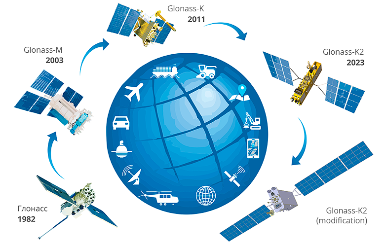
GLONASS ähnelt in Aufbau und Funktionsweise dem US-amerikanischen NAVSTAR-GPS. Die Satelliten der GLONASS-Konstellation tragen den Namen Uragan (Hurrikan). Technisch basiert GLONASS auf ähnlichen Prinzipien wie GPS. Die parallele, unabhängige Entwicklung der beiden gleichwertigen Systeme während des Kalten Krieges erfolgte aus militärstrategischen Gründen.
Die Entwicklung des Systems begann 1972. Die ersten drei Satelliten starteten am 12. Oktober 1982, das System ist am 24. September 1993 offiziell als betriebsbereit erklärt worden. Der Vollausbau, bestehend aus 21 Standard- und drei Reservesatelliten, wurde 1996 erreicht. In den Folgejahren ging die Anzahl funktionstüchtiger Satelliten aber dramatisch zurück, so dass GLONASS als eigenständiges Navigationssystem nicht nutzbar war.
Am 12. September 2008 ordnete der Ministerpräsident von Russland, Wladimir Putin, die Wiedervervollständigung von GLONASS für 67 Milliarden Rubel (1,8 Milliarden Euro) bis ins Jahr 2012 an.[1] Trotz des Fehlstarts einer Trägerrakete am 5. Dezember 2010, bei dem drei Satelliten verloren gingen,[2] stand ab 2011 wieder ein vollständiges GLONASS-System zur Verfügung. Am 2. Juli 2013 kam es erneut zu einem Absturz einer Proton-M-Rakete, bei dem wiederum drei GLONASS-Satelliten zerstört wurden.[3]
Im Juli 2010 kündigte Wladimir Jewtuschenkow, Chef der für GLONASS zuständigen Unternehmensgruppe Sistema, an, dass Russland ein Importverbot für Mobiltelefone plant, die nicht mit dem System ausgestattet sind.[4]
GLONASS(グロナス、ロシア語: ГЛОНАСС - ГЛОбальная НАвигационная Спутниковая Система、ラテン文字転記: GLObal'naya NAvigatsionnaya Sputnikovaya Sistema、英語: Global Navigation Satellite System)は、かつてのソビエト連邦が開発し、現在はロシア宇宙軍の手によってロシア政府のために運用されている衛星測位システムである。アメリカ合衆国によって運用されているグローバル・ポジショニング・システム(GPS)や、欧州連合(EU)によって計画されているガリレオなどに対応した、ロシアの衛星測位システムである。
GLONASSの開発は1976年に始められ、全世界を1991年までにサービス範囲に収めることを目標としていた。人工衛星の打ち上げは1982年10月12日から始められ、1996年に24基全ての衛星が運用開始されるまで多数のロケットの打ち上げが行われた。完成後、ロシア経済の崩壊に伴いシステムは急速に能力を失った。
ロシアは2001年からシステムの修復を開始し、近年システムを多角化してインド政府を協力者に迎え、2009年までに全世界をカバーする計画を推進[1]し、2011年に全世界で実用可能となった。
GLONASS (Russian: ГЛОНАСС, IPA: [ɡɫɐˈnas]; Глобальная навигационная спутниковая система, transliteration: Globalnaya navigatsionnaya sputnikovaya sistema), or "GLObal NAvigation Satellite System", is a space-based satellite navigation system operating as part of a radionavigation-satellite service. It provides an alternative to GPS and is the second navigational system in operation with global coverage and of comparable precision.
Manufacturers of GPS navigation devices say that adding GLONASS made more satellites available to them, meaning positions can be fixed more quickly and accurately, especially in built-up areas where buildings may obscure the view to some GPS satellites.[1][2][3] GLONASS supplementation of GPS systems also improves positioning in high latitudes (north or south).[4]
Development of GLONASS began in the Soviet Union in 1976. Beginning on 12 October 1982, numerous rocket launches added satellites to the system, until the completion of the constellation in 1995. After a decline in capacity during the late 1990s, in 2001, the restoration of the system was made a government priority and funding increased substantially. GLONASS is the most expensive program of the Russian Federal Space Agency, consuming a third of its budget in 2010.
By 2010 GLONASS had achieved full coverage of Russia's territory and in October 2011 the full orbital constellation of 24 satellites was restored, enabling full global coverage. The GLONASS satellites' designs have undergone several upgrades, with the latest version, GLONASS-K2, scheduled to enter service in 2019.[5] An announcement predicts the deployment of a group of communications and navigational satellites by 2040. The task also includes the delivery to the Moon of a series of spacecraft for orbital research and the establishment of a lunar communications and positioning system.[6]
GLONASS (en russe : ГЛОНАСС, acronyme pour глобальная навигационная спутниковая система, globalnaïa navigatsionnaïa spoutnikovaïa sistéma, soit « système global de navigation satellitaire ») est un système de positionnement par satellites d'origine soviétique et géré par les forces spatiales de la Fédération de Russie. Le segment spatial utilise vingt-quatre satellites circulant sur une orbite moyenne. Le système devient opérationnel en 1996 mais la crise financière et économique qui frappe la Russie à la fin des années 1990 ne lui permet plus de maintenir un nombre de satellites suffisant. Le service complet n'est restauré qu'au cours des années 2010. Le programme GLONASS est né dans les années 1980, durant la Guerre froide. Les satellites qui le composent reçoivent le nom Ouragan (11F654) et leur réalisation est confiée au bureau d'études en mécanique appliquée de Jeleznogorsk. D'une masse de 1 413 kg, ils sont mis en orbite par groupe de trois sur des orbites à 19 130 km, contenues dans trois plans orbitaux inclinés de 65 degrés environ.
GLONASS (russo: ГЛОНАСС; ГЛОбальная НАвигационная Спутниковая Система; Global'naja Navigacionnaja Sputnikovaja Sistema. GLObal NAvigation Satellite System) è un sistema satellitare globale di navigazione russo, controparte del Global Positioning System degli Stati Uniti e del sistema di posizionamento Galileo, sviluppato in Europa. È gestito dalle Forze Spaziali Russe (VKS).
Nel 1996, periodo di massima efficienza il sistema offriva servizi di posizionamento e tempo standard con un'accuratezza in orizzontale di 55 metri, verticale 70 metri, misura di velocità in 15 cm/s e tempo 1 µs quando il ricevitore era in vista di quattro satelliti. Un segnale più accurato era a disposizione dei soli militari russi. Nel 2013 con il rinnovo della rete satellite, la precisione migliorò, arrivando a 2,8 metri.[1]
Similmente al GPS, la flotta ufficiale GLONASS comprende 31 satelliti Uragan, 24 operativi e quattro di scorta, disposti su tre piani orbitali. Alcuni satelliti sono fuori uso o di emergenza. Ogni piano ospita otto satelliti identificati da un numero di slot che identifica il satellite ed il piano: 1-8, 9-16, 17-24. I tre piani sono separati da 120° ed i satelliti di uno stesso piano distanziati 45° tra loro. Le orbite sono pressoché circolari con una inclinazione di 64,8° e un semiasse maggiore di 25440 km. I satelliti orbitano ad una quota di 19100 km, leggermente inferiore ai satelliti GPS e compiono una rotazione ogni 11 ore e un quarto. In questo modo sono visibili in ogni momento almeno cinque satelliti.
Tutti i satelliti sono stati lanciati dal cosmodromo di Bajkonur in Kazakistan; i primi nell'ottobre 1982, resi operativi nel dicembre 1983. Il sistema avrebbe dovuto essere operativo già nel 1991, ma dopo un primo rinvio al 1993 l'attivazione non fu completata prima del dicembre 1995.
A causa della grave situazione economica della Russia, nel 2002 erano ancora operativi solamente otto satelliti e la rete era pressoché inutilizzabile. Con il migliorare della situazione economica i satelliti operativi furono portati a 11 nel marzo del 2004. Tre satelliti di nuova concezione, con una vita operativa estesa a sette anni, furono lanciati il 26 dicembre 2004. In seguito ad un accordo commerciale con l'India, la rete è tornata pienamente operativa nell'aprile 2010, con 21 satelliti in funzione su 24.
A luglio 2012 la costellazione è ritornata pienamente operativa con 24 satelliti attivi, una "riserva" di 4 satelliti e 3 satelliti in stato di riparazione o fuori uso. Ciò permette un'ottima copertura quasi paragonabile al sistema americano GPS. L'ultima volta che ci furono 24 satelliti operativi fu il 1996, anno in cui le difficoltà finanziarie della Russia comportarono il decadimento del numero di satelliti funzionanti.[2]
Dopo anni in cui il sistema è stato penalizzato dal costo dei ricevitori GLONASS e dalla loro difficile reperibilità, a fine 2011 cominciano ad apparire sul mercato dispositivi elettronici di consumo che integrano ricevitori GPS+Glonass (dei quali il più famoso è stato l'iPhone 4S[3]. Dal 2012 in poi, la compatibilità con Glonass è diventata una caratteristica comune a molti dispositivi tra i quali Samsung Galaxy S3 e S4, iPhone 5, 5c e 5s, Samsung Galaxy Ace 2, Nokia Lumia 920) e molti altri. Anche il SoC Snapdragon di Qualcomm integra un ricevitore GPS+Glonass[4].
GLONASS (acrónimo en ruso, ГЛОНАСС, ГЛОбальная НАвигационная Спутниковая Система tr.: Global'naya Navigatsionnaya Sputnikovaya Sistema) es un Sistema Global de Navegación por Satélite (GNSS) desarrollado por la Unión Soviética, siendo hoy administrado por la Federación Rusa y que constituye el homólogo del GPS estadounidense y del Galileo europeo.
Consta de una constelación de 31 satélites (24 en activo, 3 satélites de repuesto, 2 en mantenimiento, uno en servicio y otro en pruebas) situados en tres planos orbitales con 8 satélites cada uno y siguiendo una órbita inclinada de 64,8° con un radio de 25.510 km. La constelación de GLONASS se mueve en órbita alrededor de la Tierra con una altitud de 19.100 km (diecinueve mil cien kilómetros) algo más bajo que el GPS (20.200 km) y tarda aproximadamente 11 horas y 15 minutos en completar una órbita.
El sistema está a cargo del Ministerio de Defensa de la Federación Rusa y los satélites se han lanzado desde Baikonur, en Kazajistán.
Los tres primeros satélites fueron colocados en órbita en octubre de 1982. El sistema fue pensado para ser funcional en el año 1991, pero la constelación no fue terminada hasta diciembre de 1995 y comenzó a ser operativo el 18 de enero de 1996. Ese mismo año la ya Federación Rusa ofreció el canal de exactitud normalizada (CSA) del GLONASS para apoyar las necesidades de la Organización de Aviación Civil Internacional OACI, y ésta aceptó el ofrecimiento.
GLONASS utilizó inicialmente el sistema geodésico ruso PZ-90 que era sensiblemente diferente del sistema WGS 84; y como los parámetros de transformación entre los dos sistemas de referencia no se conocían con precisión, era necesario prestar atención a los sistemas a los que se referían los datos recibidos. En septiembre de 2007, el sistema fue adaptado y actualizado. Llamado PZ-90.02, está de acuerdo con el sistema ITRF2000, que se ajusta como WGS 84.1
La situación económica de Rusia en los años 90 supuso que en abril de 2002 sólo 8 satélites estuvieran completamente operativos.
En 2004, 11 satélites se encontraban en pleno funcionamiento. A finales de 2007 son 19 los satélites operativos. Son necesarios 18 satélites para dar servicio a todo el territorio ruso y 24 para poder estar disponible el sistema en todo el mundo.
En 2007, Rusia anuncia que a partir de ese año se eliminan todas las restricciones de precisión en el uso de GLONASS, permitiendo así un uso comercial ilimitado. Hasta entonces las restricciones de precisión para usos civiles eran de 30 metros.
La aparición en el mercado de receptores que permiten recibir señales pertenecientes a los dos sistemas GLONASS y GPS (con sistemas de referencia diferentes) hace interesantes las posibilidades de GLONASS en la medición como apoyo al GPS estadounidense.
Глоба́льная навигацио́нная спу́тниковая систе́ма (ГЛОНА́СС) — российская спутниковая система навигации, одна из двух[источник не указан 255 дней] полностью функционирующих на сегодня систем глобальной спутниковой навигации[1].
Система ГЛОНАСС, имевшая изначально военное предназначение, была запущена одновременно с системой предупреждения о ракетном нападении (СПРН) в 1982 году для оперативного навигационно-временного обеспечения неограниченного числа пользователей наземного, морского, воздушного и космического базирования, например, пассивных метео-РЛС типа РАЗК «Положение-2». Дополнительно система транслирует гражданские сигналы, доступные в любой точке земного шара, предоставляя навигационные услуги на безвозмездной основе и без ограничений.
Основой системы являются 24 спутника, движущихся над поверхностью Земли в трёх орбитальных плоскостях с наклоном орбитальных плоскостей 64,8° и высотой орбит 19 100 км[2]. Принцип измерения аналогичен американской системе навигации NAVSTAR GPS. Основное отличие от системы GPS в том, что спутники ГЛОНАСС в своём орбитальном движении не имеют резонанса (синхронности) с вращением Земли, что обеспечивает им бо́льшую стабильность. Таким образом, группировка космических аппаратов (КА) ГЛОНАСС не требует дополнительных корректировок в течение всего срока активного существования. Тем не менее, срок службы спутников ГЛОНАСС заметно короче.
Развитием проекта ГЛОНАСС занимается «Роскосмос», АО «„Информационные спутниковые системы“ имени академика М. Ф. Решетнёва» и АО «Российские космические системы»[3]. Для обеспечения коммерциализации и массового внедрения технологий ГЛОНАСС в России и за рубежом постановлением Правительства РФ в июле 2009 года был создан «Федеральный сетевой оператор в сфере навигационной деятельности», функции которого были возложены на ПАО «Навигационно-информационные системы». В 2012 году федеральным сетевым оператором в сфере навигационной деятельности было определено некоммерческое партнёрство «Содействие развитию и использованию навигационных технологий»[4].

Das GNU-Projekt (Aussprache: [ˈɡnuː][1]) wurde von Richard Stallman mit dem Ziel gegründet, ein offenes, unixähnliches Betriebssystem zu schaffen, das sicherstellt, dass die Endbenutzer die Freiheiten haben, es verwenden, untersuchen, verbreiten (kopieren) und ändern zu dürfen. Software, die diese Freiheits-Rechte (über ihre Lizenz) garantiert, wird Freie Software (Free Software) genannt; und GNU („GNU’s Not Unix“) fällt somit darunter. Bekannt geworden ist das Projekt vor allem auch durch die von ihm eingeführte GNU General Public License (GPL), unter der viele bekannte Softwareprojekte veröffentlicht werden, sowie zahlreicher GNU Programme, wie der GNU Compiler Collection, des GNU Debuggers sowie Werkzeuge der GNU coreutils, des Editors Emacs, usw.
Automobile
*Self-driving car
IT-Times
Agriculture, forestry, livestock, fishing
Military, defense and equipment
Navigation Satellite System
Ships and Nautics
Transport and traffic
United States
Science and technology

Das Global Positioning System (GPS; deutsch Globales Positionsbestimmungssystem), offiziell NAVSTAR GPS, ist ein globales Navigationssatellitensystem zur Positionsbestimmung. Es wurde seit den 1970er-Jahren vom US-Verteidigungsministerium entwickelt und löste ab etwa 1985 das alte Satellitennavigationssystem NNSS (Transit) der US-Marine ab, ebenso die Vela-Satelliten zur Ortung von Kernwaffenexplosionen. GPS ist seit Mitte der 1990er-Jahre voll funktionsfähig und ermöglicht seit der Abschaltung der künstlichen Signalverschlechterung (Selective Availability) am 2. Mai 2000 auch zivilen Nutzern eine Genauigkeit von oft besser als 10 Metern. Die Genauigkeit lässt sich durch Differenzmethoden (Differential-GPS/DGPS) in der Umgebung eines Referenzempfängers auf Werte im Zentimeterbereich oder besser steigern. Mit den satellitengestützten Verbesserungssystemen (SBAS), die Korrekturdaten über geostationäre, in den Polargebieten nicht zu empfangende Satelliten verbreiten und ebenfalls zur Klasse der DGPS-Systeme gehören, werden kontinentweit Genauigkeiten von einem Meter erreicht. GPS hat sich als das weltweit wichtigste Ortungsverfahren etabliert und wird in Navigationssystemen weitverbreitet genutzt.
Die offizielle Bezeichnung ist „Navigational Satellite Timing and Ranging – Global Positioning System“ (NAVSTAR GPS). NAVSTAR wird manchmal auch als Abkürzung für „Navigation System using Timing and Ranging“ genutzt. GPS wurde am 17. Juli 1995 offiziell in Betrieb genommen.
Die Abkürzung GPS ist inzwischen so sehr etabliert, dass sie umgangssprachlich, zum Teil sogar fachsprachlich, als generische Bezeichnung oder pars pro toto für alle Satellitennavigationssysteme benutzt wird.
全球定位系统(英语:Global Positioning System,通常简称GPS),又称全球卫星定位系统,是美国国防部研制和维护的中距离圆型轨道卫星导航系统。它可以为地球表面绝大部分地区(98%)提供准确的定位、测速和高精度的标准时间。全球定位系统可满足位于全球地面任一处或近地空间的军事用户连续且精确的确定三维位置、三维运动和时间的需求。该系统包括太空中的31颗GPS人造卫星;地面上1个主控站、3个数据注入站和5个监测站,及作为用户端的GPS接收机。最少只需其中3颗卫星,就能迅速确定用户端在地球上所处的位置及海拔高度;所能接收到的卫星讯号数越多,解码出来的位置就越精确。
该系统由美国政府于1970年代开始进行研制,并于1994年全面建成。使用者只需拥有GPS接收机即可使用该服务,无需另外付费。GPS信号分为民用的标准定位服务(SPS,Standard Positioning Service)和军用的精确定位服务(PPS,Precise Positioning Service)两类。由于GPS无须任何授权即可任意使用,原本美国因为担心敌对国家或组织会利用GPS对美国发动攻击,故在民用讯号中人为地加入选择性误差(即SA政策,Selective Availability)以降低其精确度,使其最终定位精确度大概在100米左右;军规的精度在十米以下。2000年以后,比尔·克林顿政府决定取消对民用讯号的干扰。因此,现在民用GPS也可以达到十米左右的定位精度。[1]
GPS系统拥有如下多种优点:使用低频讯号,纵使天候不佳仍能保持相当的讯号穿透性;高达98%的全球覆盖率;高精度三维定速定时;快速、省时、高效率;应用广泛、多功能;可移动定位。不同于双星定位系统,使用过程中接收机不需要发出任何信号;此举增加了隐蔽性,提高了其军事应用效能。
グローバル・ポジショニング・システム(英語: Global Positioning System, Global Positioning Satellite, GPS、全地球測位システム)とは、アメリカ合衆国によって運用される衛星測位システム(地球上の現在位置を測定するためのシステムのこと)を指す。ロラン-C(Loran-C: Long Range Navigation C)システムなどの後継にあたる。
アメリカ合衆国が軍事用に打ち上げた約30個のGPS衛星のうち、上空にある数個の衛星からの信号をGPS受信機で受け取り、受信者が自身の現在位置を知るシステムである。
元来は軍事用として開発されていたが、大韓航空機撃墜事件の発生後、運用が開始されれば民間機の安全な航行のために非軍事的な用途(民生的用途)でも使えるよう開放する事がレーガン大統領により表明された。その後、民生運用に足る精度を満たした「初期運用宣言」は1993年に、軍事運用可能な精度を満たした「完全運用宣言」は1995年に成された[1]。
GPSは地上局を利用するロラン(LORAN)-Cと異なり、受信機の上部を遮られない限り、地形の影響を受けて受信不能に陥る事が少ない。[注釈 1]
GPS衛星からの信号には、衛星に搭載された原子時計からの時刻のデータ、衛星の天体暦(軌道)の情報などが含まれている。GPS衛星からの電波を受信し、その発信時刻を測定し、発信と受信との時刻差に、電波の伝播速度(光速)を掛けることによって、その衛星からの距離がわかる。
もしもGPS受信機に搭載されている時計の誤差が100万分の1秒あったとしたら、距離の誤差は300mにも及んでしまう。そこで、多くの受信機は4つ以上のGPS衛星からの電波を受信することで現在時刻を頻繁に校正し、正確な受信時刻と受信機座標(3次元空間上の点)とを測位計算により同時に求める。
GPS衛星は約20,000kmの高度を一周約12時間で動く準同期衛星である(静止衛星ではない)。いくつかの軌道上に打ち上げられた30個ほどの衛星コンステレーションで地球上の全域をカバーできる。また中地球軌道なので信号の送信電力としても有利であり、ある地域からみても刻々と配置が変化するため、全地球上で誤差を平均化できる(地域によってはカバーする衛星の個数が常に少ない場合もある)。
The Global Positioning System (GPS), originally NAVSTAR GPS,[1] is a satellite-based radionavigation system owned by the United States government and operated by the United States Air Force.[2] It is a global navigation satellite system (GNSS) that provides geolocation and time information to a GPS receiver anywhere on or near the Earth where there is an unobstructed line of sight to four or more GPS satellites.[3] Obstacles such as mountains and buildings block the relatively weak GPS signals.
The GPS does not require the user to transmit any data, and it operates independently of any telephonic or internet reception, though these technologies can enhance the usefulness of the GPS positioning information. The GPS provides critical positioning capabilities to military, civil, and commercial users around the world. The United States government created the system, maintains it, and makes it freely accessible to anyone with a GPS receiver.[4]
The GPS project was started by the U.S. Department of Defense in 1973, with the first prototype spacecraft launched in 1978 and the full constellation of 24 satellites operational in 1993. Originally limited to use by the United States military, civilian use was allowed from the 1980s. Advances in technology and new demands on the existing system have now led to efforts to modernize the GPS and implement the next generation of GPS Block IIIA satellites and Next Generation Operational Control System (OCX).[5] Announcements from Vice President Al Gore and the White House in 1998 initiated these changes. In 2000, the U.S. Congress authorized the modernization effort, GPS III. During the 1990s, GPS quality was degraded by the United States government in a program called "Selective Availability"; this was discontinued in May 2000 by a law signed by President Bill Clinton.[6]
The GPS service is provided by the United States government, which can selectively deny access to the system, as happened to the Indian military in 1999 during the Kargil War, or degrade the service at any time.[7] As a result, several countries have developed or are in the process of setting up other global or regional satellite navigation systems. The Russian Global Navigation Satellite System (GLONASS) was developed contemporaneously with GPS, but suffered from incomplete coverage of the globe until the mid-2000s.[8] GLONASS can be added to GPS devices, making more satellites available and enabling positions to be fixed more quickly and accurately, to within two meters (6.6 ft).[9] China's BeiDou Navigation Satellite System began global services in 2018, with full deployment scheduled for 2020. There are also the European Union Galileo positioning system, and India's NAVIC. Japan's Quasi-Zenith Satellite System (QZSS) is a GPS satellite-based augmentation system to enhance GPS's accuracy in Asia-Oceania, with satellite navigation independent of GPS scheduled for 2023.[10]
When selective availability was lifted in 2000, GPS had about a five-meter (16 ft) accuracy. The latest stage of accuracy enhancement uses the L5 band and is now fully deployed. GPS receivers released in 2018 that use the L5 band can have much higher accuracy, pinpointing to within 30 centimeters or 11.8 inches.[11][12]
Le Global Positioning System (GPS) (en français : « Système mondial de positionnement » [littéralement] ou « Géo-positionnement par satellite »), originellement connu sous le nom de Navstar GPS, est un système de positionnement par satellites appartenant au gouvernement des États-Unis. Mis en place par le département de la Défense des États-Unis à des fins militaires à partir de 1973, le système avec 24 satellites est totalement opérationnel en 1995 et s'ouvre au civil en 2000.
Les signaux transmis par les satellites peuvent être librement reçus et exploités par quiconque. L'utilisateur, qu'il soit sur terre, sur mer ou dans les airs, peut connaître sa position à toute heure et en tout lieu sur la surface ou au voisinage de la surface de la terre avec une précision sans précédent, dès lors qu'il est équipé d'un récepteur GPS et du logiciel nécessaire au traitement des informations reçues.
Le principe de fonctionnement repose sur la trilatération de signaux électromagnétiques synchronisés émis par les satellites. Pour assurer la précision du positionnement, le système GPS utilise des technologies sophistiquées : horloges atomiques embarquées, compensation d'effets relativistes, mise en place de stations d'observation et de synchronisation. Les coordonnées terrestres calculées se réfèrent au système géodésique WGS 84.
Commercialement, le GPS connait un grand succès et engendre de nombreux développements dans une multitude de domaines : navigations maritime, terrestre et aérienne, localisation de flottilles commerciales (bateaux, avions, camions), suivi et traçage de parcours, évaluation de la pertinence d'itinéraire. L'intégration de « puces GPS » dans les smartphones multiplie les usages domestiques ou individuels. Dans le milieu scientifique la précision de la localisation et de la synchronisation permettent de développer et d'exploiter de nouvelles applications : géodésie, synchronisation entre horloges atomiques, étude de l'atmosphère, etc.
L'Europe, la Chine, la Russie et l'Inde, conscients de l'intérêt stratégique d'un tel système de positionnement par satellites développent depuis quelques années des systèmes concurrents.
Nelle telecomunicazioni il sistema di posizionamento GPS (acronimo in inglese: Global Positioning System, a sua volta abbreviazione di NAVSTAR GPS, acronimo di NAVigation Satellite Timing And Ranging Global Positioning System o di NAVigation Signal Timing And Ranging Global Position System[1]) è un sistema di posizionamento e navigazione satellitare militare statunitense. Attraverso una rete dedicata di satelliti artificiali in orbita, fornisce a un terminale mobile o ricevitore GPS informazioni sulle sue coordinate geografiche e sul suo orario in ogni condizione meteorologica, ovunque sulla Terra o nelle sue immediate vicinanze dove vi sia un contatto privo di ostacoli con almeno quattro satelliti del sistema. La localizzazione avviene tramite la trasmissione di un segnale radio da parte di ciascun satellite e l'elaborazione dei segnali ricevuti da parte del ricevitore.
Il sistema GPS è gestito dal governo degli Stati Uniti d'America ed è liberamente accessibile da chiunque sia dotato di un ricevitore GPS. Il suo grado attuale di accuratezza è dell'ordine di pochi metri[2], in dipendenza dalle condizioni meteorologiche, dalla disponibilità e dalla posizione dei satelliti rispetto al ricevitore, dalla qualità e dal tipo di ricevitore, dagli effetti di radiopropagazione del segnale radio in ionosfera e troposfera (es. rifrazione) e dagli effetti della relatività.
Il GPS è stato creato in sostituzione del precedente sistema, il Transit.
Il progetto GPS è stato sviluppato nel 1973 per superare i limiti dei precedenti sistemi di navigazione[3], integrando idee di diversi sistemi precedenti, tra cui una serie di studi classificati degli anni sessanta. Il GPS è stato creato e realizzato dal Dipartimento della Difesa statunitense (USDOD) ed originariamente disponeva di 24 satelliti. Il sistema è diventato pienamente operativo nel 1994.
Nel 1991 gli USA aprirono al mondo il servizio per usi civili con il nome SPS (Standard Positioning System), con specifiche differenziate da quello riservato all'uso delle forze militari USA denominato PPS (Precision Positioning System). Il segnale civile era intenzionalmente degradato attraverso la Selective Availability (SA) che introduceva errori intenzionali nei segnali satellitari allo scopo di ridurre l'accuratezza della rilevazione, consentendo precisioni dell'ordine di 900–950 m. Questa degradazione del segnale è stata disabilitata nel mese di maggio 2000 grazie a un decreto del presidente degli Stati Uniti Bill Clinton, mettendo così a disposizione degli usi civili la precisione attuale di circa 10–20 m, anche se tra i due sistemi permangono delle differenze descritte più avanti. Per impedirne il montaggio su missili, nei modelli per uso civile devono essere presenti alcune limitazioni: massimo 18 km per l'altitudine e 515 m/s per la velocità. Questi limiti possono essere superati, ma non contemporaneamente.
El Sistema de Posicionamiento Global (en inglés, GPS; Global Positioning System), y originalmente Navstar GPS, es un sistema que permite determinar en toda la Tierra la posición de cualquier objeto (una persona, un vehículo) con una precisión de hasta centímetros (si se utiliza GPS diferencial), aunque lo habitual son unos pocos metros de precisión. El sistema fue desarrollado, instalado y empleado por el Departamento de Defensa de los EE. UU. Para determinar su posición, un usuario utiliza 4 o más satélites y utiliza la trilateración.
El GPS funciona mediante una red de como mínimo 24 satélites en órbita sobre el planeta Tierra, a aproximadamente 20.000 km de altura, con órbitas distribuidas para que en todo momento haya al menos 4 satélites visibles en cualquier punto de la tierra. Cuando se desea determinar la posición tridimensional, el receptor que se utiliza para ello localiza automáticamente como mínimo cuatro satélites de la red, de los que recibe unas señales indicando la identificación y hora del reloj de cada uno de ellos, además de información sobre la constelación. Con base en estas señales, el aparato sincroniza su propio reloj con el tiempo del sistema GPS y calcula el tiempo que tardan en llegar las señales al equipo, y de tal modo mide la distancia al satélite. Mediante el método de trilateración inversa, computa su propia posición. Se también una gran exactitud en el tiempo, basado en los relojes atómicos a bordo cada uno de los satélites y en el segmento terreno de GPS.
La antigua Unión Soviética construyó un sistema similar llamado GLONASS, ahora gestionado por la Federación Rusa.
La Unión Europea desarrolló el sistema de navegación Galileo. En diciembre de 2016 la Comisión Europea, propietaria del sistema, informó que el sistema de navegación Galileo comenzó sus operaciones y que los satélites ya envían información de posicionamiento, navegación y determinación de la hora a usuarios de todo el mundo.
La República Popular China está implementando su propio sistema de navegación, el denominado Beidou, que está previsto que cuente con 12 y 14 satélites entre 2011 y 2015. Para 2020, ya plenamente operativo deberá contar con 30 satélites. En diciembre de 2012 tenían 14 satélites en órbita.[cita requerida]
GPS (англ. Global Positioning System — система глобального позиционирования, читается Джи Пи Эс) — спутниковая система навигации, обеспечивающая измерение расстояния, времени и определяющая местоположение во всемирной системе координат WGS 84. Позволяет почти при любой погоде определять местоположение в любом месте Земли (исключая приполярные области) и околоземного космического пространства. Система разработана, реализована и эксплуатируется Министерством обороны США, при этом в настоящее время доступна для использования для гражданских целей — нужен только навигатор или другой аппарат (например, смартфон) с GPS-приёмником.
Основной принцип использования системы — определение местоположения путём измерения моментов времени приёма синхронизированного сигнала от навигационных спутников антенной потребителя. Для определения трёхмерных координат GPS-приёмнику нужно иметь четыре уравнения: «расстояние равно произведению скорости света на разность моментов приёма сигнала потребителем и момента его синхронного излучения от спутников»: 
Здесь:
— радиус-вектор
-го спутника,
— момент времени приёма сигнала от
— неизвестный момент времени синхронного излучения сигнала всеми спутниками по часам потребителя,
— скорость света,
— неизвестный радиус-вектор потребителя.

Hersteller: Great Western Railway Swindon Works Baujahr(e): 1847–1855 1871–1888 „Rover“ Ausmusterung: 1892 Achsformel: 2A1 Gattung: 4-2-2 (Whyte-Notation) Spurweite: 2140 mm Fester Radstand: 5705 mm / 18 ft 8½ in 5795 mm „Rover“ Gesamtradstand: 5705 mm / 18 ft 8½ in 5795 mm „Rover“ Höchstgeschwindigkeit: 80 mph bzw. 128 km/h Treibraddurchmesser: 2440 mm bzw. 8 ft Laufraddurchmesser vorn: 1370 mm bzw. 4 ft 6 in Laufraddurchmesser hinten: 1370 mm bzw. 4 ft 6 in Zylinderdurchmesser: 457 mm bzw. 18 in Kolbenhub: 610 mm bzw. 24 in
 Energy resource
