
Deutsch-Chinesische Enzyklopädie, 德汉百科
 Malaysia
Egypt
China
India
Malaysia
Egypt
China
India

 IT-Times
 Late Classical, Romantic (Early, Middle, Late)
Italy
Japan
Jordan
Malaysia
Republic of Korea
Saudi Arabia
Shanghai Shi-SH
Spain
Thailand
United Arab Emirates
United Kingdom
Zhejiang Sheng-ZJ
Late Classical, Romantic (Early, Middle, Late)
Italy
Japan
Jordan
Malaysia
Republic of Korea
Saudi Arabia
Shanghai Shi-SH
Spain
Thailand
United Arab Emirates
United Kingdom
Zhejiang Sheng-ZJ
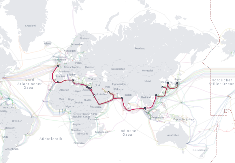
 Transport and traffic

 Architecture
 Religion

 Sport
Sport

 Geography

孟加拉湾(印地语:बंगाल की खाड़ी、孟加拉语:বঙ্গোপসাগর、缅甸语:ဘင်္ဂလားပင်လယ်အော်)是印度洋北部的一个海湾,西临印度半岛,东临中南半岛,北临缅甸和孟加拉国,南在斯里兰卡至苏门达腊岛一线与印度洋本体相交,经马六甲海峡与暹罗湾和南海相连。宽约1600公里,面积217万平方公里;水深2000-4000米,南部较深;盐度30-34‰。
沿岸国家有印度、孟加拉国、缅甸、泰国、斯里兰卡、马来西亚和印度尼西亚。
印度和缅甸的一些主要河流均流入孟加拉湾,著名的大河有:恒河、布拉马普特拉河、伊洛瓦底江、萨尔温江、克里希纳河等等。孟加拉湾中著名的岛屿包括斯里兰卡岛、安达曼群岛、尼科巴群岛、普吉岛等。
孟加拉湾沿岸贸易发达,主要港口有:印度的加尔各答、金奈、本地治里、孟加拉国的吉大港、缅甸的仰光、毛淡棉、泰国的普吉、马来西亚的槟榔屿、印度尼西亚的班达亚齐、斯里兰卡的贾夫纳等等。
Der Golf von Bengalen (bengalisch বঙ্গোপসাগর baṅgopasāgar; indonesisch Teluk Benggala;malaiisch Teluk Bengal; thailändisch อ่าวเบงกอล; seltene deutsche Bezeichnungen: Bengalischer Golf, Bengalischer Meerbusen, Bai von Bengalen[1][2][3][4]) ist ein nordöstliches Randmeer des Indischen Ozeans mit einer Fläche von rund 2.171.000 km². Er ist 2090 km lang und bis zu 1610 km breit und hat grob gesehen die Form eines Dreiecks. Der Golf ist durchschnittlich 2600 Meter und maximal 4694 Meter tief. Er trennt die Landmasse des indischen Subkontinents von der Halbinsel Hinterindien. Das Klima ist vom Monsun geprägt. Besonderheiten der Region sind insbesondere eine Reihe von Schlammvulkanen sowie die größten Mangrovenwälder der Erde, wie die Sundarbans.
Der Golf von Bengalen wird im Westen von Sri Lanka und Indien, im Norden von der namensgebenden Region Bengalen, bestehend aus dem Staat Bangladesch und dem indischen Bundesstaat Westbengalen sowie im Osten von Myanmar, Thailand und Indonesien begrenzt. Im Süden ist er mit dem Indischen Ozean verbunden. Als ungefähre Abgrenzung des Golfes kann eine gedachte Linie zwischen der Südspitze Sri Lankas und der Nordspitze der zu Indonesien gehörenden Insel Sumatra angenommen werden.
ベンガル湾(ベンガルわん、Bay of Bengal)は、インド洋の北東部分の湾。湾はほぼ三角形で、南方に開けた形となっている。東にマレー半島、西にインド亜大陸、北に名前の元となったインドの西ベンガル州およびバングラデシュに面している。南端はスリランカとアンダマン・ニコバル諸島連邦直轄地に面している。同諸島の東側の海域はアンダマン海と呼ばれる。
インドやバングラデシュの多くの川がベンガル湾に流れ込んでいる。北からはガンジス川、メグナ川とブラマプトラ川が流れ込み、南西の沿岸であるオリッサ州からはマハナディ川、ゴータヴァリー川、クリシュナ川、カヴェリ川が流れ込んでいる。湾の北端のインド領には、スンダルバンス国立公園があり、豊かなマングローブの林がある。ミャンマーのエーヤワディー川もベンガル湾に流れ込んでいる。
チェンナイ(旧名マドラス)やコルカタ(旧名カルカッタ)といった大都市がベンガル湾に接しており、古くから交易拠点として栄えてきた。
The Bay of Bengal is the northeastern part of the Indian Ocean, bounded on the west and northwest by India, on the north by Bangladesh, and on the east by Myanmar and the Andaman and Nicobar Islands of India. Its southern limit is a line between Sangaman Kanda, Sri Lanka and the north westernmost point of Sumatra (Indonesia). It is the largest water region called a bay in the world. There are countries dependent on the Bay of Bengal in South Asia and Southeast Asia. In ancient India, Bay of Bengal was known as Kalinga Sagar. Later during the British India, it came forth as the Bay of Bengal after the historic Bengal region, as the Port of Kolkata served as the gateway to the Crown rule in India. Cox's Bazar, the longest sea beach in the world and Sundarbans, the largest mangrove forest and the natural habitat of the Bengal tiger, are located along the bay.
The Bay of Bengal occupies an area of 2,600,000 square kilometres (1,000,000 sq mi). A number of large rivers flow into the Bay of Bengal: the Ganges–Hooghly, the Padma, the Brahmaputra–Jamuna, the Barak–Surma–Meghna, the Irrawaddy, the Godavari, the Mahanadi, the Brahmani, the Baitarani, the Krishna and the Kaveri. Among the important ports are Chennai, Ennore, Chittagong, Colombo, Kolkata-Haldia, Mongla, Paradip, Port Blair, Thoothukudi, Visakhapatnam and Dhamra. Among the smaller ports are Gopalpur Port, Kakinada and Payra.
Le golfe du Bengale (bengali : বঙ্গপসাগর, anglais : Bay of Bengal) est une mer qui forme la partie du nord-est de l'océan Indien. Elle a la forme d'un triangle encadré à l'est par les côtes birmanes jusqu'au cap Negrais puis par les archipels Andaman et Nicobar, et à l'ouest par le sous-continent indien. Au nord du golfe, on trouve l'état indien du Bengale-Occidental et le Bangladesh, d'où provient son nom. Ses limites méridionales sont le pont d'Adam puis une ligne ouest-est ayant son origine à la pointe sud de l'île de Sri Lanka, et finissant à la pointe nord de l'île indonésienne de Breueh (Pulau Breueh), non loin de Sumatra.
Il golfo del Bengala (বঙ্গোপসাগর in bengalese, ဘင်္ဂလားပင်လယ်အော် in birmano, बंगाल की खाड़ी in hindi e බෙංගාල බොක්ක in singalese) è l'insenatura più ampia del mondo e, per le sue dimensioni (2.172.000 km² di superficie), al punto che può essere considerato un mare vero e proprio. Di forma approssimativamente triangolare, costituisce la parte nordorientale dell'Oceano Indiano ed è collocato fra il Subcontinente indiano a ovest e l'Indocina ad est.
El Golfo de Bengala es un mar en el área noreste del océano Índico. Su forma se parece a un triángulo. Limita al este con la península de Malaca, al oeste con el subcontinente indio. El extremo norte del golfo limita con el estado indio de Bengala Occidental y con Bangladés. Los extremos del sur están limitados por la isla de Sri Lanka y el territorio indio de las Islas Andamán y Nicobar. Estas últimas islas separan el golfo de Bengala del mar de Andamán (también mar de Birmania).
Muchos de los ríos principales de la India desembocan desde el oeste en la bahía de Bengala: en el norte el río Ganges (o Ganga), el río Meghna y el río Brahmaputra. Al sur el Mahanadi, el Godavari, el Krishna y el Kaveri (también escrito Cauvery). El bosque de mangle llamado los Sundarbans está situado en el delta que forman los ríos Ganges, Brahmaputra y Meghna en el golfo de Bengala.
Los puertos indios más importantes del golfo son Madrás, Vishakhapatnam, Calcuta y Pondicherry.
Бенга́льский зали́в (бенг. বঙ্গোপসাগর, там. வங்காள விரிகுடா, хинди बंगाल की खाड़ी, англ. Bay of Bengal[1]) — морской залив, расположенный в северо-восточной части Индийского океана, омывает берега Индии, Бангладеш, Мьянмы и Шри-Ланки. На западе ограничен полуостровом Индостан, на востоке — побережьем Мьянмы и островными дугами Андаманских и Никобарских островов. У северной оконечности залива располагается историческая область Бенгалия (включающая современную Бангладеш и индийский штат Западная Бенгалия), давшая ему название. Является самым большим заливом в мире, его площадь — 2191 тысяча км²[2] (по другим данным 2173 тысячи км²[1]). Наибольшая глубина — 4519 м[2], средняя — 2600 м[1].
В Бенгальский залив впадают многие крупные реки — Ганг, Брахмапутра и Мегхна (общий эстуарий), Кришна, Годавари, Кавери, Маханади, Иравади.
На северо-восточном побережье залива, у города Кокс-Базар (Бангладеш) расположен самый протяжённый в мире пляж (120 км).
По гидрологическому, гидрохимическому и прочим параметрам Бенгальский залив относится к морям.

泰国湾(泰语:อ่าวไทย)又称暹罗湾(泰语:อ่าวสยาม),是泰王国的南海湾,其东南部通南中国海,泰国、柬埔寨、越南濒临其北部和东部,泰国、马来西亚在其西部。
泰国湾长720多公里,宽约480-560公里;水域面积大约32万平方公里,平均水深(浅)仅45米,平均盐度约为百分之三点五。
Der Golf trennt die östliche Indochinesische von der Malaiischen Halbinsel im Westen. Die Küstenlinie verläuft von Kap Bai Bung in Vietnam im Osten bis zum Ostufer der Mündung des Sungai Kelantan in Kota Bahru (Malaysia) im Südwesten. Im Süden geht der Golf von Thailand in das Südchinesische Meer über und hat damit eine Ausdehnung von etwa 750 km × 570 Kilometer, bei einer Fläche von rund 320.000 km².
In der am nördlichen Ende des Golfes gelegenen Bucht von Bangkok münden die Flüsse Mae Nam Chao Phraya (mit dem Nebenarm Tha Chin) und der Mae Nam Mae Klong in das Meer. Ein weiterer Zufluss ist der Mae Nam Tapi, der in der Bucht von Bandon bei Surat Thani in den Golf mündet.
Durch die fortgesetzte Sedimentbildung des Chao Phraya schiebt sich die Küste Zentral-Thailands immer weiter nach Süden vor. Zehn bis 20 Kilometer vor der Küste beträgt die Wassertiefe erst elf Meter. Die durchschnittliche Tiefe des Golfs beträgt nur 45 Meter, die tiefste Stelle liegt bei 80 Metern. Während des Höhepunkts der letzten Eiszeit lag der Golf weitgehend über dem Meeresspiegel und bildete eine Verlängerung der heutigen Tiefebene des Chao Phraya in Zentralthailand.
タイランド湾(タイランドわん、Gulf of Thailand、อ่าวไทย、タイ湾[注釈 1]とも)は、太平洋南シナ海の最西部にある湾。
タイ王国、カンボジア、ベトナム、マレーシアがその海岸線を有する。南東方向に開けた湾であり、最北地点チャオプラヤー川河口を最奥に、ベトナムのバイブン岬からマレーシアのコタバル結ぶ範囲となっている。その面積は大雑把に320,000km2にも及ぶと言われる。また、タイ地域の旧称シャムに由来して、シャム湾という表記が用いられていたこともある。
湾内の水深は非常に浅く、平均は45メートルで、もっとも深いところでも80メートルである。この浅さは湾内の水流を緩やかにし、さらに、チャオプラヤー川などからの淡水流入によって、塩分濃度が3.05-3.25%とかなり低くなっているのが特徴である。ただし、南シナ海から流れてくる塩水により、濃度が一部濃くなっているところがあり、50メートル以下の場所では3.4%となっている場合もある。その水深のため、氷期の海面低下した時期においてはタイランド湾は陸地化していたが、その後、海面の上昇によって、湾が形成されたと考えられる(スンダランドを参照)。
チャオプラヤーをはじめとする複数の河川が湾奥に流れ込むことにより豊富な漁業資源が棲息し、それらを餌とするカツオクジラ[1]、ツノシマクジラ[2]、シナウスイロイルカ、カワゴンドウ、スナメリ、ジュゴン[3]、タイマイなどの貴重な海洋生物の住処にもなっている。特にカツオクジラはホエールウォッチングの対象になっている[4]。
The Gulf of Thailand, also known as the Gulf of Siam, is a shallow northwesternly inlet[1][2] in southwestern South China Sea, bounded between the southwestern shores of the Indochinese Peninsula and the northern half of the Malay Peninsula. It is around 800 km (500 mi) in length and up to 560 km (350 mi) in width, and has a surface area of 320,000 km2 (120,000 sq mi).[3][4] The gulf is surrounded on the north, west and southwest by the coastlines of Thailand (hence the name), on the northeast by Cambodia and the Mekong Delta region of Vietnam, and opens to the South China Sea in the southeast.
Le golfe de Thaïlande, aussi appelé golfe du Siam, est un golfe d'Asie adjacent à la mer de Chine méridionale, et indépendant de cette dernière (voir section "géographie"). Il est bordé par la Malaisie, la Thaïlande, le Cambodge et le Viêt Nam. La partie septentrionale du golfe constitue la baie de Bangkok, dans laquelle se jette le fleuve Chao Phraya. Le golfe a une superficie de quelque 320 000 km2.
Il golfo del Siam (in thai: อ่าวไทย; RTGS: Ao Thai, [ʔàːw tʰāj] ; detto anche golfo della Thailandia) è un golfo "confinante" con il Mar Cinese Meridionale, di cui non fa parte, mentre entrambi sono parte dell'oceano Pacifico. Le sue acque bagnano Malaysia, Thailandia, Cambogia e Vietnam.
El golfo de Tailandia o golfo de Siam está localizado en el océano Pacífico, baña las costas de Malasia, Tailandia, Camboya y Vietnam; y limita en dirección sudeste con el mar de la China Meridional.
En tailandés se llama: อ่าวไทย (RTGS: Ao Thai, Thai pronunciation: [ʔàːw tʰaj]). Los malayos lo llaman "Teluk Siam" y los camboyanos "Boeung Tonle Siem", que significan literalmente "Golfo de Siam".
En el extremo norte del golfo, el río Chao Phraya, principal tributario de este golfo, desemboca creando un amplio delta canalizado (khlongs) en el área metropolitana de Bangkok.
El golfo tiene una superficie de 320 000 km² y es relativamente poco profundo, con medias de 45 a 80 metros de profundidad. Esto último hace que la circulación del agua sea lenta y que los ríos Chao Phraya y Mekong ejerzan una fuerte influencia sobre el mismo como una baja salinidad y una gran riqueza en sedimentos. Durante las épocas más frías de la era glacial, el golfo de Tailandia no existía debido a su poca profundidad y era tan solo una prolongación del valle del río Chao Phraya.
Debido al clima tropical, las aguas del golfo abrigan una buena cantidad de arrecifes de coral y por lo tanto existen muchos proyectos de explotación de los mismos. Alberga también riquezas petrolíferas y gas; y es un medio de intercambio turístico y comercial entre los países que tienen costa en él.
Las principales islas del golfo son Koh Samui, Koh Pha Ngan, Koh Chang y Koh Kut pertenecientes a Tailandia, Koh Kong y Koh Rong a Camboya y Phu Quoc a Vietnam.
Сиа́мский зали́в[1][2], Таила́ндский зали́в[1] (тайск. อ่าวไทย, Ау Тхай[3]) — часть Южно-Китайского моря, омывающая на западе и севере берега Таиланда, на востоке — Камбоджи и Вьетнама, на юго-западе — Малайзии.
 Motorsport

赛道简介:
雪邦吉隆坡赛道是1999年F1新 增加的一站大奖赛。这里的一切设施都堪称一流,同时拥有很长的一个维修赛道,赛道也富有多样性,因此对每一位车手都是一个挑战,从缩略图看,马力大而且悬 挂好的赛车更有优势。每年的雪邦大奖赛都是在赛季中后期进行,但是今年国际汽联将比赛时间提前,对组委会来说将面临不小的考验。(Quelle:http://zhuanti.nubb.com/200803o/137489.html)


 Party and government

 Driving school
Egypt
Australia
Belgium
Brazil
Denmark
Germany
Finland
France
Greece
Driving school
Egypt
Australia
Belgium
Brazil
Denmark
Germany
Finland
France
Greece
 Hand in Hand
Driver's license
India
Indonesia
Italy
Japan
Canada
Kasachstan
Croatia
Malaysia
Mexico
Hand in Hand
Hand in Hand
Driver's license
India
Indonesia
Italy
Japan
Canada
Kasachstan
Croatia
Malaysia
Mexico
 Mongolei
New Zealand
Netherlands
Useful info
Austria
Portugal
Republic of Korea
Russia
Saudi Arabia
Sweden
Switzerland
Singapore
Spain
South Africa
Thailand
Czech Republic
Turkey
Hungary
Mongolei
New Zealand
Netherlands
Useful info
Austria
Portugal
Republic of Korea
Russia
Saudi Arabia
Sweden
Switzerland
Singapore
Spain
South Africa
Thailand
Czech Republic
Turkey
Hungary
 Vacation and Travel
United Arab Emirates
United States
United Kingdom
Vacation and Travel
United Arab Emirates
United States
United Kingdom
国际驾驶执照(International Driving Permit)依照1949年日内瓦国际道路交通公约及1968年维也纳国际道路交通公约,由公约签署国政府签发,方便本国驾驶员在其他签约国驾驶私人车辆。国际驾驶执照为附加在一国驾驶执照之上的一本附加多国语言的说明,标注了驾驶人的基本信息以及允许驾驶的对应车辆种类等,解决驾驶员与其他国家的交通管理部门之间的沟通障碍。国际驾照不能独立存在,当驾驶员同时持有一国驾照与该国政府签发的国际驾照时,此国际驾照才视作有效。[1]
国际驾驶执照之内容及格式依照维也纳道路交通会议制订,但并非各国均批准该公约。
Ein Internationaler Führerschein ist ein Dokument, das von den Straßenverkehrsbehörden oder Automobilclubs[1] eines Landes aufgrund zwischenstaatlicher Verträge ausgestellt wird. Er soll vor allem der Polizei eines anderen Landes die Feststellung ermöglichen, ob ein ausländischer Kraftfahrer die Fahrerlaubnis hat, die für sein aktuelles Fahrzeug erforderlich ist.
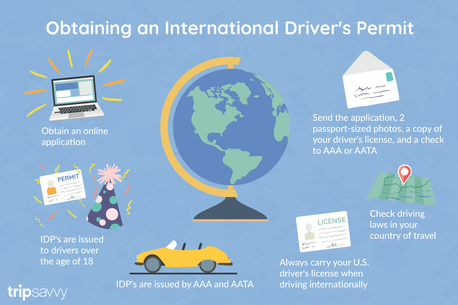
An International Driver's Permit (IDP) allows you to drive a vehicle in another country, as long as you also have a valid driver's license issued by your state. It is also recognized as a proper form of identification in over 175 countries and by many major car rental companies internationally.
Getting an International Driver's Permit (sometimes incorrectly called an international driver's license) can take anywhere from a day to a few weeks, depending on whether you're going through walk-in processing or applying via mail, so make sure to plan ahead if you're planning to drive on your international trip. There are only two locations in the United States that issue these documents: The American Automobile Association (AAA) and the American Automobile Touring Alliance (AATA).
In the United States, International Driver Permits (IDPs) are only issued by the American Automobile Association and the American Automobile Touring Alliance, and the State Department recommends against purchasing an IDP from other outlets as they are all entirely illegal to buy, carry, or sell.
IDPs can be issued to anyone over 18 who has had a valid driver's license for six months or longer. They typically remain valid for one year or the expiration of your existing state driving license. It's essential to investigate an IDP before your trip and make sure you know the requirements.
Both AAA and AATA are excellent sources for these documents, so once you've selected a provider, go to either the AAA's or NAATA's website, print out the International Driving Permit Application, complete all applicable fields, and submit it.
Once you have the application completed, you can send it in via the mail or visit a local office of an organization like AAA; you'll also need two original passport-sized photos and a signed copy of your valid U.S. driver's license as well as an enclosed check for the fee.
Tips to Getting and Using Your Permit
AAA offices can process IDPs during your visit, but processing generally takes 10 to 15 business days if you send the application in. However, expedited services may be available to get your license within one or two business days for an additional fee.
When applying, you'll need a computer and printer, a completed application, a copy of your valid U.S. driver's license, two passport photos, and a check, money order, or credit card to complete the process. Remember to bring these with you if you're applying in person.
Always make sure to carry your valid United States driver's license when driving internationally, as your IDP is invalid without this accompanying proof of eligibility to drive. IDPs only translate domestically-accepted licenses and do not allow those without government-issued driver's licenses to drive abroad.
You'll also want to make sure to enclose the proper fees (the fee for the IDP, as well as any shipping and handling fees), photos, and photocopies of your license when submitting your application to AAA or AATA as omitting any of these required documents will result in your application being rejected.
You should also check the driving requirements and laws for the countries you will be driving in on your vacation, so you'll know what will be required in the event you get stopped by local authorities. (Quelle:https://www.tripsavvy.com/)