


 Antigua and Barbuda
Bahamas
Barbados
Belize
Columbia
Costa Rica
Cuba
Dominica
Dominikanische Republik
Grenada
Guatemala
Guyana
Honduras
Jamaika
Mexico
Nicaragua
Panama
Republik El Salvador
Republik Haiti
Saint Kitts and Nevis
St. Lucia
St. Vincent and the Grenadines
Suriname
Trinidad und Tobago
Venezuela
Antigua and Barbuda
Bahamas
Barbados
Belize
Columbia
Costa Rica
Cuba
Dominica
Dominikanische Republik
Grenada
Guatemala
Guyana
Honduras
Jamaika
Mexico
Nicaragua
Panama
Republik El Salvador
Republik Haiti
Saint Kitts and Nevis
St. Lucia
St. Vincent and the Grenadines
Suriname
Trinidad und Tobago
Venezuela


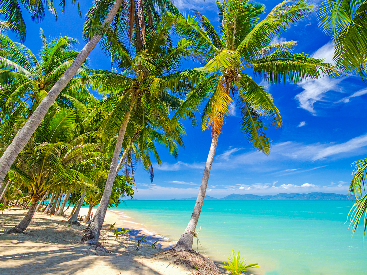


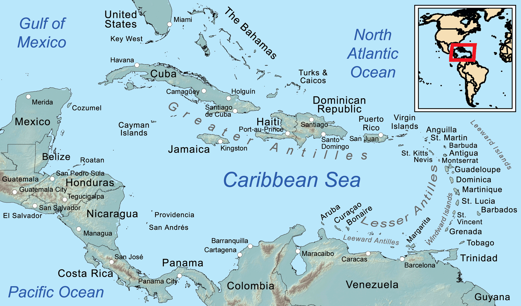
Die Karibik ist eine Region im westlichen, tropischen Teil des Atlantischen Ozeans nördlich des Äquators. Als Teil des mittelamerikanischen Subkontinents besteht sie aus den am und im Karibischen Meer gelegenen Inseln und Inselgruppen und dem Meeresgebiet zwischen ihnen. Am Westende reicht die Karibik in den Golf von Mexiko.
Die Karibik ist nach dem Volk der Kariben benannt, das die spanischen Eroberer auf den Kleinen Antillen (lat. ante ilium, „vorgelagerte Inseln“) vorgefunden haben. Sie wurde bzw. wird auch Westindien genannt, da man sich bei ihrer Entdeckung auf direktem Seeweg nach Indien glaubte.
若依照联合国地理分区里的地理亚区来判定,加勒比地区的范围为加勒比海上的诸岛—西印度群岛,国家与地区包含安圭拉、安提瓜和巴布达、阿鲁巴、巴哈马、巴巴多斯、博奈尔、圣尤斯特歇斯和萨巴、英属维尔京群岛、开曼群岛、古巴、库拉索、多米尼克、多米尼加、格林纳达、瓜德罗普、海地、牙买加、马提尼克、蒙特塞拉特、波多黎各、圣巴泰勒米、圣基茨和尼维斯、圣卢西亚、法属圣马丁、圣文森特和格林纳丁斯、荷属圣马丁、特立尼达和多巴哥、特克斯和凯科斯群岛、美属维尔京群岛。
カリブ海地域(カリブかいちいき、英語: The Caribbean、スペイン語: Caribe、オランダ語: ![]() Caraïben、カリブ・ヒンドゥスターニー語: कैरिबियन (Kairibiyana); フランス語: Caraïbe ないし Antilles)は、カリブ海と、その海域の島々(カリブ海域内の島々や、カリブ海と北大西洋の境界を成す島々)、周辺海域から構成されている。カリブ海地域はメキシコ湾と北アメリカ大陸の南東、中央アメリカの東、南アメリカ大陸の北に位置している。日本語ではカリブ地域、あるいはこの地域にある国を総称してカリブ諸国とも呼ばれる。
Caraïben、カリブ・ヒンドゥスターニー語: कैरिबियन (Kairibiyana); フランス語: Caraïbe ないし Antilles)は、カリブ海と、その海域の島々(カリブ海域内の島々や、カリブ海と北大西洋の境界を成す島々)、周辺海域から構成されている。カリブ海地域はメキシコ湾と北アメリカ大陸の南東、中央アメリカの東、南アメリカ大陸の北に位置している。日本語ではカリブ地域、あるいはこの地域にある国を総称してカリブ諸国とも呼ばれる。
この地方の大部分はカリブプレート上にあり、域内には700以上の島嶼、岩礁、キー(サンゴ礁上の低い島)などがある(カリブ海地域の島の一覧)。島々の多くは島弧を形成して、カリブ海のと東渕と北縁となっている[3]。カリブ海地域の島々は、北側の大アンティル諸島と、南および東側の小アンティル諸島(リーワード・アンティル諸島を含む) から成り、大アンティル諸島やカリブ海より北に位置するバハマ諸島(バハマからタークス・カイコス諸島に至る範囲)をも含んだ、より広い範囲を指す表現としての西インド諸島の一部となっている。広い意味では、大陸の一部であるベリーズ、ベネズエラ、ガイアナ、スリナム、フランス領ギアナもカリブ海地域に含める場合がある。
地政学的には、カリブ海地域の島々は北アメリカの下位区分 (subregion) と見なされることが多く[4][5][6][7][8]、合わせて30の主権国家、海外県、属領から成っている。1954年12月15日から2010年10月10日まで、5つの統治体から成るオランダ領アンティルと称されたオランダ属領があった[9]。また、1958年1月3日から1962年5月31日まで、イギリス属領であった英語圏の領域が構成した、西インド連邦と称された短命な自治国が存在していた。クリケット西インド諸島代表は、その後も、これら諸国の多くを代表して編成され続けている。
The Caribbean (/ˌkærɪˈbiːən, kəˈrɪbiən/, locally /ˈkærɪbiæn/;[4] Spanish: El Caribe; French: les Caraïbes; Haitian Creole: Karayib; Dutch: De Caraïben; Papiamento: Karibe) is a region of the Americas that consists of the Caribbean Sea, its islands (some surrounded by the Caribbean Sea[5] and some bordering both the Caribbean Sea and the North Atlantic Ocean)[6] and the surrounding coasts. The region is southeast of the Gulf of Mexico and the North American mainland, east of Central America, and north of South America.
Situated largely on the Caribbean Plate, the region has more than 700 islands, islets, reefs and cays (see the list of Caribbean islands). Island arcs delineate the eastern and northern edges of the Caribbean Sea:[7] the Greater Antilles on the north and the Lesser Antilles on the south and east (which includes the Leeward Antilles). They form the West Indies with the nearby Lucayan Archipelago (The Bahamas and the Turks and Caicos Islands), which are sometimes considered to be a part of the Caribbean despite not bordering the Caribbean Sea. On the mainland, Belize, Nicaragua, the Caribbean region of Colombia, Cozumel, the Yucatán Peninsula, Margarita Island, and The Guianas (Guyana, Suriname, French Guiana, Guayana Region in Venezuela, and Amapá in Brazil) are often included due to their political and cultural ties with the region.[8]
A mostly tropical geography, the climates are greatly shaped by sea temperatures and precipitation, with the hurricane season regularly leading to natural disasters. Because of its tropical climate and low-lying island geography, the Caribbean is vulnerable to a number of climate change effects, including increased storm intensity, saltwater intrusion, sea-level rise and coastal erosion, and precipitation variability.[9] These weather changes will greatly change the economies of the islands, and especially the major industries of agricultural and tourism.[9]
The Caribbean was occupied by indigenous people since at least 3600 BC. When European colonization followed the arrival of Columbus, the population was quickly decimated by brutal labor practices, enslavement and disease and on many islands, Europeans supplanted the native populations with enslaved Africans. Following the independence of Haiti from France in the early 19th century and the decline of slavery in the 19th century, island nations in the Caribbean gradually gained independence, with a wave of new states during the 1950s and 60s. Because of the proximity to the United States, there is also a long history of United States intervention in the region.
The islands of the Caribbean (the West Indies) are often regarded as a subregion of North America, though sometimes they are included in Middle America or then left as a subregion of their own[10][11] and are organized into 30 territories including sovereign states, overseas departments, and dependencies. From December 15, 1954, to October 10, 2010, there was a country known as the Netherlands Antilles composed of five states, all of which were Dutch dependencies.[12] From January 3, 1958, to May 31, 1962, there was also a short-lived political union called the West Indies Federation composed of ten English-speaking Caribbean territories, all of which were then British dependencies.
Les Caraïbes, (également nommées la Caraïbe, l'espace caraïbe, ou encore l'espace des Caraïbes) sont une région des Amériques qui comprend la mer des Caraïbes, ses îles (certaines entourées par la mer des Caraïbes et d'autres bordant à la fois la mer des Caraïbes et l'océan Atlantique Nord) et les côtes environnantes. La région est située au sud-est du golfe du Mexique et du continent nord-américain, à l'est de l'Amérique centrale et au nord de l'Amérique du Sud.
Située en grande partie sur la plaque des Caraïbes, la région compte plus de 700 îles, îlots, récifs et cayes. Les arcs insulaires délimitent les bords est et nord de la mer des Caraïbes : les Grandes Antilles au nord et les Petites Antilles au sud et à l'est (qui comprennent les îles sous le vent). Elles forment les Antilles avec l'archipel voisin de Lucayan (les Bahamas et les Îles Turques-et-Caïques), qui sont parfois considérées comme faisant partie des Caraïbes bien qu'elles ne bordent pas la mer des Caraïbes. Sur le continent, le Belize, le Nicaragua, la région caribéenne de Colombie, Cozumel, la péninsule du Yucatán, l'île de Margarita et les Guyanes (Guyane, Suriname, Guyane française, région de Guayana au Venezuela et Amapá au Brésil) sont souvent inclus en raison de leurs liens politiques et culturels avec la région.
La géographie est essentiellement tropicale et le climat est fortement influencé par la température de la mer et les précipitations, la saison des ouragans entraînant régulièrement des catastrophes naturelles. En raison de leur climat tropical et de leur géographie insulaire de basse altitude, les Caraïbes sont vulnérables à un certain nombre d'effets du changement climatique, notamment l'augmentation de l'intensité des tempêtes, l'intrusion d'eau salée, l'élévation du niveau de la mer et l'érosion côtière, ainsi que la variabilité des précipitations.
Les Caraïbes ont été occupées par des peuples indigènes depuis au moins 3600 avant J.-C. Lorsque la colonisation européenne a suivi l'arrivée de Christophe Colomb, la population a été rapidement décimée par des pratiques de travail brutales, l'esclavage et la maladie et sur de nombreuses îles, les Européens ont supplanté les populations indigènes par des Africains réduits en esclavage. Après l'indépendance d'Haïti par rapport à la France au début du XIXe siècle et le déclin de l'esclavage, les nations insulaires ont progressivement acquis leur indépendance, avec une vague de nouveaux États au cours des années 1950 et 1960. En raison de la proximité des États-Unis, il existe également une longue histoire d'intervention américaine dans la région.
Les Antilles sont souvent considérées comme une sous-région de l'Amérique du Nord, bien qu'elles soient parfois incluses dans l'Amérique centrale ou alors laissées comme une sous-région à part entière et sont organisées en 30 territoires comprenant des États souverains, des Département et région d'outre-mer et des dépendances. Du 15 décembre 1954 au 10 octobre 2010, il y avait un pays appelé Antilles néerlandaises composé de cinq États, tous dépendants des Pays-Bas. Du 3 janvier 1958 au 31 mai 1962, il y a également eu une union politique de courte durée, la Fédération des Indes occidentales, composée de dix territoires caribéens anglophones, tous dépendants des Britanniques à l'époque.
I Caraibi sono una vasta regione geografica delle Americhe che comprende tutti i paesi bagnati dal Mare Caraibico, cioè tutte le isole delle Antille e i litorali di alcuni paesi continentali del centro e sud America che si affacciano su di questo mare. L'area caraibica è costituita dalle numerose isole che separano il Golfo del Messico dal mar dei Caraibi e quest'ultimo dall'Oceano Atlantico.
El Caribe es una región conformada por el mar Caribe, sus islas y las costas que rodean a este mar. La región se localiza al sureste de América del Norte, al este de América Central, al oeste de América Insular y al norte de América del Sur.
Анти́льские острова́ (также Карибы или Карибские острова) — острова в Карибском море и Мексиканском заливе, расположенные между Северной Америкой и Южной Америкой. Вместе взятые, образуют площадь в 228 662 км² с населением примерно 42 млн чел. (на начало XXI века).
Впервые название «Антильские» встречается в 1493 году у Петра Мартира д’Ангиера, современника Христофора Колумба, придворного Фердинанда Арагонского и Изабеллы Кастильской. Предположительно, были названы по полумифическому острову или архипелагу Антилия, изображавшемуся на средневековых картах.
Подразделяются на две главные группы: Большие Антильские и Малые Антильские острова:
К первым относятся 4 острова: Куба, Гаити, Ямайка и Пуэрто-Рико; из них первые два и последний (самый малый) образуют почти прямую линию, направленную западным углом Кубы к полуострову Юкатан.[1]
Острова материкового и вулканического происхождения. Большая часть их поверхности гориста; равнинные участки главным образом на Кубе и на Юго-Восточном Гаити, а также на Виргинских и Подветренных островах. Горные сооружения Больших Антильских островов высотой до 3098 м (на острове Гаити) являются продолжением структур Центральной Америки. Климат тропический, пассатный, жаркий, преимущественно летне-влажный. Осадков 1200—2000 мм в год. Характерны сильные ураганы в конце лета. Естественная растительность — саванны, летне-зеленые и листопадно-вечнозелёные тропические леса и кустарники — сохранилась мало. На наветренных склонах гор уцелели вечнозелёные леса.[2]