German — Chinese


拉萨,简称“拉”,是中国西藏自治区的首府,具有高原和民族特色的国际旅游城市 ,是西藏的政治、经济、文化和科教中心,也是藏传佛教圣地。位于西藏高原的中部,喜马拉雅山脉北侧,海拔3650米(要防内源氧缺乏症),地处雅鲁藏布江支流拉萨河中游河谷平原,拉萨河流经此,在南郊注入雅鲁藏布江。
拉萨全年多晴朗天气,降雨稀少,冬无严寒,夏无酷暑,气候宜人。全年日照时间在3000小时以上,素有“日光城”的美誉。拉萨境内蕴藏着丰富的各类资源,相对于全国和自治区其他地市,具有较明显的资源优势。
作为首批国家历史文化名城,拉萨以风光秀丽、历史悠久、风俗民情独特、宗教色彩浓厚而闻名于世,先后荣获中国优秀旅游城市、欧洲游客最喜爱的旅游城市、全国文明城市、中国最具安全感城市、中国特色魅力城市200强、世界特色魅力城市200强 、2018畅游中国100城等荣誉称号。
拉萨(藏文:ལྷ་ས་;藏语拼音:Lhasa;威利:lha-sa;国际音标:/l̥ásə/ 或 /l̥ɜ́ːsə/),唐代译作逻些、逻逤、逻娑,为中华人民共和国西藏自治区首府。拉萨处海拔3,650米,拉萨河流经此,在南郊注入雅鲁藏布江。
拉萨历来是西藏全区政治、经济及文化的中心,也是藏传佛教圣地。1960年正式设市,1982年又定为国家历史文化名城。
Lhasa (Tibetisch: ལྷ་ས་, Wylie: lha sa, auch Lasa, chinesisch 拉萨, Pinyin Lāsà) ist die Hauptstadt des Autonomen Gebiets Tibet der Volksrepublik China.
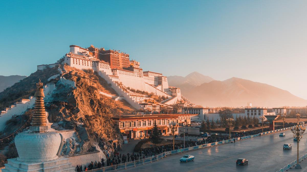
Sie liegt in einem Hochgebirgstal und wurde bei einem Tempel begründet. Noch heute hat sie große religiöse Bedeutung und beherbergt viele Mönche. Eine wichtige Sehenswürdigkeit ist der Potala-Palast, der ehemalige Palast des Dalai Lama.
Seit 2006 ist Lhasa an das chinesische Eisenbahnnetz angebunden. Die mehrheitlich von Tibetern bewohnte Stadt hat im inneren Stadtbezirk einen Han-Bevölkerungsanteil von rund einem Drittel.
ラサ市(ラサし)は、中華人民共和国チベット自治区の中央部に位置し、同自治区を構成する「地級市」のひとつ。中国政府がチベットの古都ラサとその周辺地域をあわせて1960年に設置した。
市域はチベットの古都ラサとその郊外からなる「城関区」とトゥールン・デチェン区の2つの市轄区、その周辺の6つのゾン(県)で構成されている。「地級市」は、中国の行政区画制度において、二級行政区画に分類される行政体の一種である。自治区人民政府は城関区内に設置されている。本市の東方に位置するロカ市とともに、中央チベット東部の「ウー地方」を構成する。
総面積3万平方キロ、市区面積523平方キロ。 人口37.3万人、非農業人口14万人。チベット族が87%を占める。
本市の中心部に設置された城関区は、古くからチベットの政治的、文化的中枢であった古都・ラサであり、吐蕃王朝やダライ・ラマ政権の時代には首都がおかれた。この古都ラサはチベット、モンゴル、満州などの諸民族から構成されるチベット仏教文化圏の中枢都市であった。
中華人民共和国が1956年に設置した西蔵自治区籌備委員会(チベット自治区準備委員会)はこの市に本拠を置き、1965年に発足させた西蔵自治区の首府にもなっている。
Lhasa[a] is a prefecture-level city, formerly a prefecture until 7 January 1960, one of the main administrative divisions of the Tibet Autonomous Region of China. It covers an area of 29,274 square kilometres (11,303 sq mi) of rugged and sparsely populated terrain. The consolidated prefecture-level city is divided into five mostly rural counties and three partially urban districts Chengguan District, Doilungdêqên District, and Dagzê District, which contain the main urban area of Lhasa.
The prefecture-level city roughly corresponds to the basin of the Lhasa River, a major tributary of the Yarlung Tsangpo River. It lies on the Lhasa terrane, the last unit of crust to accrete to the Eurasian plate before the continent of India collided with Asia about 50 million years ago and pushed up the Himalayas. The terrane is high, contains a complex pattern of faults and is tectonically active. The temperature is generally warm in summer and rises above freezing on sunny days in winter. Most of the rain falls in summer. The upland areas and northern grasslands are used for grazing yaks, sheep and goats, while the river valleys support agriculture with crops such as barley, wheat and vegetables. Wildlife is not abundant, but includes the rare snow leopard and black-necked crane. Mining has caused some environmental problems.
The 2000 census gave a total population of 474,490, of whom 387,124 were ethnic Tibetans. The Han Chinese population at the time was mainly concentrated in urban areas. The prefecture-level city is traversed by two major highways and by the Qinghai–Tibet Railway, which terminates in the city of Lhasa. Two large dams on the Lhasa River deliver hydroelectric power, as do many smaller dams and the Yangbajain Geothermal Station. The population is well-served by primary schools and basic medical facilities, although more advanced facilities are lacking. Tibetan Buddhism and monastic life have been dominant aspects of the local culture since the 7th century. Most of the monasteries were destroyed during the Cultural Revolution, but since then many have been restored and serve as tourist attractions.
Lhassa (tibétain : ལྷ་ས་, Wylie : lha sa, THL : lhasa ; translittération phonétique en chinois : 拉萨 ; pinyin : Lāsà), capitale du royaume du Tibet depuis le VIIe siècle, puis de l'Ü-Tsang à partir de l'ère de la fragmentation fut le siège du gouvernement religieux puis politique du Ganden Phodrang, sous le règne religieux du Lozang Gyatso, 5e dalaï-lama et temporel du Mongol qoshot Güshi Khan roi du Tibet sous le Khanat qoshot, sous la tutelle mandchoue de la dynastie Qing, puis sous le Tibet indépendant du 13e dalaï-lama, au début du XXe siècle, est actuellement le chef-lieu de la région autonome du Tibet, région autonome de la République populaire de Chine, appelée plus couramment Tibet, bien qu'elle ne couvre qu'environ la moitié du Tibet durant l'apogée de l'Empire du Tibet (629 – 877).
La ville s'est développée au pied du mont Gephel.
Le palais du Potala, ancien palais du dalaï-lama, chef religieux sous le contrôle du Khanat qoshot, puis également temporel lors le Tibet sous la tutelle des Qing, et pendant l'indépendance de facto du Tibet (1912 — 1951). Le palais du Potala, le temple de Jokhang, ainsi que le palais de Norbulingka, ancienne résidence d'été des dalaï-lamas, sont classés au patrimoine mondial par l'UNESCO.
Lhasa (in lingua cinese 拉萨市S, Lāsà ShìP, in tibetano ལྷ་ས་གྲོང་ཁྱེར།, Lha sa grong khyerW, Lhasa ChongkyirP che significa "trono di Dio") situata a 3.650 m di altitudine nella valle del Kyi Chu, è la principale città del Tibet, territorio fin dal 1750 direttamente o indirettamente controllato dalla Cina (e ora dalla Repubblica Popolare Cinese). Attualmente Lhasa è quindi la capitale della Regione Autonoma del Tibet. Era anche la residenza tradizionale del Dalai Lama.
Lhasa (en tibetano, ལྷ་ས། chino simplificado: 拉萨, chino tradicional: 拉薩, pinyin: Lāsà) es la capital de la Región Autónoma del Tíbet, en la República Popular China. Se encuentra situada en la Meseta Tibetana, rodeada por las montañas del Himalaya. Cuenta con una población de alrededor de 250 000 habs. Se encuentra a una altitud de 3650 msnm, en el valle del río Brahmaputra, siendo la segunda ciudad más alta de Asia y una de las más altas del mundo, tanto que la cantidad de oxígeno disponible es solo un 68% a nivel del mar.2
La ciudad es la sede tradicional de los lamas y lugar donde se encuentran los palacios de Potala, Norbulingka y el Templo de Jokhang, incluidos en el Patrimonio de la Humanidad3 y es considerado por el budismo tibetano como el centro más sagrado del Tíbet.
Lhasa quiere decir "Lugar de los Dioses", aunque antiguos documentos tibetanos e inscripciones han demostrado que hasta principios del siglo VII el lugar se llamaba Rasa, que significa "lugar de cabra".4
Limita al norte con la prefectura de Nagou, al este con la prefectura de Nyingchi, al sur con la prefectura de Shannan, y al suroeste con la prefectura de Xigaze.
Comprende los barrios o distritos de Lhünzhub, Damxung, Nyêmo, Qüxü, Doilungdêqê, Dagzê y Maizhokunggar.
Лха́са (произносится l̥ásə, тиб. ལྷ་ས, Вайли lha sa, кит. трад. 拉薩, упр. 拉萨, пиньинь: Lāsà) — городской округ в Тибетском автономном районе КНР, место размещения правительства автономного района, бывшая столица независимого Тибетского государства. То, что часто называют «городом Лхаса» (историческая столица Тибета) — это современный район Чэнгуань городского округа Лхаса. Лхаса является также традиционной резиденцией Далай-ламы. Буквально в переводе с тибетского «лхаса» означает «место богов».
Произношение Лха́са следует старому тибетскому[1] (придыхание; в современном языке произносится хЛаса[2][3]; ударение падает на второй слог[1]), Ласа́ — китайскому (拉萨 Lāsà)[4] и английскому (Lhasa — «h» не произносится) языкам.


 History
 World Heritage


