
Deutsch-Chinesische Enzyklopädie, 德汉百科
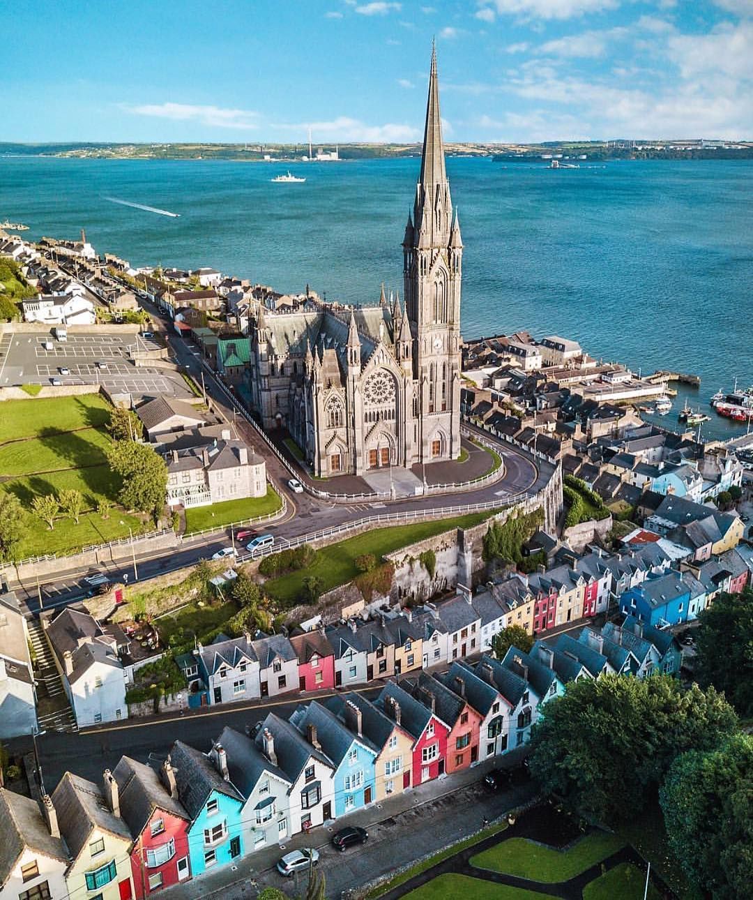

Donostia-San Sebastián (baskisch Donostia [dɔ'nɔɕtija], spanisch San Sebastián) ist die Hauptstadt der Provinz Gipuzkoa (spanisch Guipúzcoa) in der spanischen Autonomen Gemeinschaft Baskenland. Sie liegt etwa 20 km westlich der französischen Grenze im Bogen des Golfs von Biskaya. Die Stadt war 2016 gemeinsam mit Breslau Kulturhauptstadt Europas. San Sebastián liegt im äußersten Norden der Iberischen Halbinsel an der Bucht La Concha (deutsch: Die Muschel), deren Name von ihrer auffälligen Form herrührt. Die Landesgrenze mit Frankreich liegt nur 20 Kilometer von San Sebastián entfernt. Die Mündung der Bucht wird durch die Felsmassive des Monte Igueldo und des Monte Urgull begrenzt, in der Ausfahrt selbst liegt die kleine Felseninsel Santa Clara. Der weitläufige Bogen der Bucht mit der Strandpromenade und der zwischen La Concha und der Mündung des Flusses Urumea gelegene Parte Vieja-Alde Zaharra (deutsch: Altstadt) sind bekannte Touristenattraktionen.
圣塞瓦斯蒂安(巴斯克语:Donostia/[do'noʃtia];西班牙语:San Sebastián,官方称呼:Donostia-San Sebastián)是西班牙吉普斯夸省省会,属于巴斯克自治区。该市位于西班牙东北部,濒临比斯开湾,紧邻法国边境。圣塞瓦斯蒂安如画的海岸线使它成为广受欢迎的海滨旅游胜地。其位于市中心的两个沙滩,贝壳海滩和翁达勒塔海滩,是市中心的一个特色,被誉为“欧洲最漂亮的沙滩”。
 Eurovision Song Contest,ESC
 UEFA European Championship 2020

 History
 M 1500 - 2000 AD

 History
 N 2000 - 2100 AD

 International cities
 *European Capital of Culture

 International cities
 ***Global Urban Economic Competitiveness
 Ireland

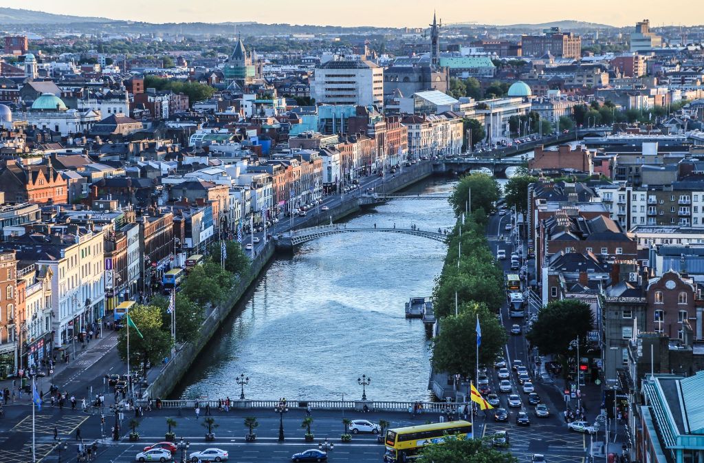
都柏林(英语:Dublin;爱尔兰语:Baile Átha Cliath)是爱尔兰共和国的首都以及最大的城市,[3][4]靠近爱尔兰岛东岸的中心点,位处都柏林郡的利菲河(River Liffey)河口、都柏林地区的中心。都柏林自中世纪以来一直是爱尔兰首都城市,也是爱尔兰岛上最大的城市。由于很多高技术企业聚集,所以有欧洲的硅谷之称。
Dublin这个字起源于爱尔兰语的Dubh Linn(意为“黑色池塘”)。都柏林的现代爱尔兰名Baile Átha Cliath(意为“芦苇障碍做成的浅滩之城”)则是指在黑色池塘旁边的定居地。
最早关于都柏林的文献是托勒密的手稿,大约写于140年,他称之为埃布拉纳(Eblana)。
都柏林在官方城市边界内的人口是大约495,000人(爱尔兰中央统计处2002年人口调查),然而这种统计已经没有什么太大的意义,因为都柏林的市郊地区和卫星城镇已经大幅地发展与扩张。都柏林市和都柏林郡的人口加起来已经超过了1,100,000人(爱尔兰中央统计处2002年人口调查)。虽然对于“大都柏林都会区”的定义没有一个确切的共识,但是普遍而言大家可以接受这个地区包括了都柏林市和郡,以及部分的威克娄郡、基尔代尔郡和米斯郡,因为通勤带可以延伸到很远的地方。
Dublin ([ˈdʌblɪn], lokal auch [dʊbᵊlən]) ist die Hauptstadt und größte Stadt der Republik Irland. Der irische Name ist Baile Átha Cliath ([ˈbalʲɑːˈkʲlʲiə] oder [ˈbʲlʲɑːˈkʲlʲiə]). Die deutsche Übersetzung lautet „Stadt an der Hürdenfurt“. Der englische Name stammt vom irischen Duibhlinn ([ˈdivʲ.lʲiːnʲ]), „Schwarzer Teich“.[1]
Dublin liegt an der Ostküste der Insel Irland, an der Mündung des Flusses Liffey in die Dublin Bay. Dublin liegt durchschnittlich 20 Meter über dem Meeresspiegel.
Die Liffey teilt Dublin in den Nordteil (Northside) und den eher vornehmen Süden (Southside), wobei diese Unterteilung heute weniger scharf ist als in früheren Jahrzehnten. Die Innenstadt erhält ihre Struktur durch das Kreuz aus dem Fluss Liffey mit seinen zahlreichen Brücken und der Hauptachse O’Connell Street–Grafton Street–Harcourt Street. Hier liegen die meisten Kaufhäuser, aber auch das Trinity College mit seiner berühmten Bibliothek und der städtische Park St. Stephen’s Green. Die Straßenzüge im typischen Georgianischen Stil findet man vor allem im Gebiet um den Merrion Square, in der Nähe der Nationalgalerie und beim Sitz der Landesregierung (Leinster House), um St. Stephen’s Green, aber auch auf der Nordseite am Mountjoy Square. Umschlossen wird dieses Gebiet von der North Circular Road und der South Circular Road. Außerhalb der Innenstadt liegen die Wohnquartiere, von denen manche noch einen sehr einheitlichen Stil aufweisen; das klassische Arbeiterviertel Cabra besteht aus langen Reihen winziger Häuser aus Backsteinen, Marino ist ein Beispiel für eine am Reißbrett konzipierte Mittelschicht-Siedlung, in Beaumont überwiegen die semi-detached, die Doppelhaushälften.
Die Geschichte Dublins ist eng mit der Geschichte Irlands im Allgemeinen verknüpft.
Die erste bekannte Erwähnung findet Dublin in den Schriften des Ptolemäus aus dem Jahr 140 unter dem Namen Eblana. Ursprünglich bestand die Stadt aus einer keltischen Siedlung mit dem Namen „Áth Cliath“, was so viel wie „Hürden-Furt“ bedeutet. 842 gründeten Wikinger daneben ein eigenes Dorf, das sie „Duibhlinn“, in etwa „schwarzer Teich“, nannten nach einem von ihnen als Hafenbecken genutzten Gewässer. Die Machtstellung des von ihnen gegründeten Königreich Dublin ging nach der Schlacht von Clontarf 1014 verloren.
Die Stadt wurde 1170 von den Anglonormannen unter der Führung von Richard de Clare und seinem irischen Verbündeten Diarmuid Mac Murchadha Caomhánach eingenommen. Ab 1172 wurde Dublin das Verwaltungszentrum der Anglonormannen. Die Stadt hatte zu der Zeit weitverzweigte internationale Handelsbeziehungen zu Skandinavien, Island, Großbritannien und in zunehmendem Maße zu Frankreich.[2]
Der Bereich der gerichtlichen Zuständigkeit der Stadt wurde 1192 in einer Urkunde niedergelegt. Insgesamt wurde ein sechs Quadratmeilen großes Gebiet durch Erlass des Königs Heinrich II. übereignet. Die Stadt blieb im Prinzip innerhalb dieser Abgrenzungen selbstverwaltet.[3]
Im Jahre 1204 befahl König Johann von England die Errichtung einer Festung in Dublin (Dublin Castle), um seine Machtposition im Land zu stärken.[4] In den folgenden Jahrhunderten entwickelte sich diese Burg zum britischen Verwaltungszentrum in Irland. Der britische Vizekönig wohnte bis 1782 in diesem Schloss.
1229 wurde den freien Bürgern und Ehrenbürgern der Stadt das Recht zuerkannt, jedes Jahr einen Bürgermeister zu wählen. Der Stadtrat setzte sich aus 24 prominenten Bürgern, meist Kaufleuten, zusammen.
Die Pest kam 1348 nach Dublin und verursachte eine beachtliche Schrumpfung der (jetzt überwiegenden englischen) Bevölkerung.
Zwischen 1541 und 1800 war Dublin Hauptstadt des Königreiches Irland.
ダブリン(英: Dublin [ˈdʌblᵻn]、アイルランド語:Baile Átha Cliath [ˈbˠalʲə aːhə ˈclʲiə]、Bleá Cliath [blʲaˈklʲiə] または Dubh linn)は、アイルランド島東部の都市で、アイルランドの首都である。リフィー川河口に位置し、その南北に町が広がる。
アイルランドの政治・経済・交通・文化の中心地であり、アイルランドの全人口の3分の1がダブリン首都圏に集中するアイルランド国内最大の都市である。欧州有数の世界都市であり、重要な金融センターの一つになっている。
市内にはアイルランド人の権利の拡大に尽力した人々やイギリスからの独立運動のために命を落とした活動家の名前が記念日や通りの名前に多く見られる。ダニエル・オコンネルに因む町の目抜き通りのオコンネル通り[3]やパトリック・ピアースにちなむピアース通り、コノリー駅などが例に挙げられる。これらは本来は別の名前がつけられていたが、1921年の独立[4]後に改名されたものである(オコンネル通りはかつてはサックビル通りと呼ばれていた)。
Dublin (/ˈdʌblɪn/, locally /ˈdʊb-/; Irish: Baile Átha Cliath[11] [ˈbˠalʲə aːhə ˈklʲiə; ˌbʲlʲaː ˈklʲiə]) is the capital and largest city of Ireland.[12][13] Situated on a bay on the east coast, at the mouth of the River Liffey, it lies within the province of Leinster. It is bordered on the south by the Dublin Mountains, a part of the Wicklow Mountains range. It has an urban area population of 1,173,179,[7] while the population of the Dublin Region (formerly County Dublin) as of 2016 was 1,347,359.[14] The population of the Greater Dublin Area was 1,904,806 per the 2016 census.[15]
There is archaeological debate regarding precisely where Dublin was established by the Gaels in or before the 7th century AD.[16] Later expanded as a Viking settlement, the Kingdom of Dublin, the city became Ireland's principal settlement following the Norman invasion.[16] The city expanded rapidly from the 17th century and was briefly the second largest city in the British Empire before the Acts of Union in 1800. Following the partition of Ireland in 1922, Dublin became the capital of the Irish Free State, later renamed Ireland.
Dublin is a historical and contemporary centre for education, the arts, administration and industry. As of 2018 the city was listed by the Globalization and World Cities Research Network (GaWC) as a global city, with a ranking of "Alpha −", which places it amongst the top thirty cities in the world.
Dublin /dyblɛ̃/a Écouter (en anglais : /ˈdʊbᵊlən/b ; en gaélique : Baile Átha Cliathc /ˈbˠalʲə aːhə ˈclʲiə/d ou Bleá Cliathe /ˌbʲlʲaː ˈclʲiə/d) est la plus grande ville de l'île d'Irlande et de l'État d'Irlande, dont elle est la capitale (Belfast étant la capitale de l'Irlande du Nord). La ville est située à proximité du point central de la côte orientale de l'île et au centre du comté de Dublin. Dublin est la plus grande ville d'Irlande en importance et en nombre d’habitants depuis le haut Moyen Âge. Elle est aujourd’hui classée à la soixante-sixième place dans l’index des places financières mondiales1, et a un des plus forts taux de développement parmi les capitales européennes2,3. Dublin est le centre historique, politique, artistique, culturel, économique et industriel de l’Irlande.
La population de la commune de Dublin est de 553 165 habitants au recensement de 2016. Au même recensement, le comté de Dublin — divisé en quatre zones administratives : ville de Dublin, Dublin Sud, Fingal et Dún Laoghaire-Rathdown — compte 1 270 603 habitants tandis que la région du Grand Dublin abrite 1 804 156 habitants.
Dublino (AFI: /duˈblino/[2]; in inglese Dublin, /ˈdʌblɪn/; in irlandese Baile Átha Cliath,[3] "città del guado della staccionata", o semplicemente Áth Cliath, o meno correttamente Dubh Linn, "stagno nero") è la capitale della Repubblica d'Irlanda, oltre che la città più grande e popolata, non solo del paese, ma di tutta l'isola. Gli abitanti sono complessivamente 554 554 ma se si considera l'area metropolitana, superano il milione.[1] La città è in continua espansione urbanistica ed economica da qualche decennio, e contribuisce al PIL della Repubblica con 60 miliardi di euro.
Fondata dai Vichinghi come centro per il commercio di schiavi, la città è situata sulla foce del fiume Liffey, al centro della costa orientale dell'isola e di quella che oggi viene chiamata Dublin Region, affacciata sul Mar d'Irlanda (in inglese Irish Sea). È stata la capitale irlandese sin dai tempi medievali.
La Città consiste nella zona amministrata dal Dublin City Council assieme ai contigui sobborghi un tempo appartenenti alla Contea di Dublino e ora divisi tra le contee di Dún Laoghaire-Rathdown, Fingal e South Dublin. La Greater Dublin Area si compone di quanto sopra assieme alle contee di Kildare, Meath e Wicklow.
Molly Malone è il titolo dell'inno non ufficiale della città.
Dublín (en irlandés: Baile Átha Cliath, AFI: [ˌbʲlʲɑː ˈclʲiə] o población del vado de cañizo;1 en inglés: Dublin, AFI: [ˈdʌblɪn]) es la capital de la República de Irlanda y ciudad más poblada de la isla. Está ubicada cerca del centro de la costa este sobre el mar de Irlanda, en la desembocadura del río Liffey y en el centro del condado de Dublín. Fue fundada por los vikingos alrededor de 841 como base militar y centro de comercio de esclavos, y ha sido capital del país desde la Edad Media.23 Está constituida por diferentes áreas; el Consejo de la Ciudad de Dublín junto con suburbios contiguos en el condado de Dublín, y que a su vez se subdivide en los condados administrativos de Dún Laoghaire-Rathdown, Fine Gall-Fingal y el Consejo del Condado de Dublín Sur. La Gran Área abarca la Ciudad de Dublín y el Consejo junto con los condados contiguos de Kildare, Meath y Wicklow.
La población del área urbana de Dublín era de 1 110 614 habitantes en el censo de 2010, pero ampliada al condado de Dublín ascendía a 1 122 821 en 2011 y en 2019 la cantidad de habitantes es 199 personas.
En la Gran Área o región metropolitana de Dublín había 1 804 156 habitantes. La ciudad contribuye con 60 000 millones de euros al PIB irlandés y es el centro político, administrativo, económico, industrial y cultural de la República de Irlanda. Dublín ha sido declarada ciudad global por el GaWC (Grupo de Estudios sobre Globalización y Ciudades Mundiales) y Capital Europea de la Ciencia 2012 debido a la celebración del día del duende.
Ду́блин[3] (англ. Dublin [ˈdʌblɨn], местн. [ˈdʊblən], [ˈdʊbələn]; ирл. Baile Átha Cliath — Балэ-Аха-Клиэх[4] [bˠalʲə aːha klʲiəh] или Duibhlinn (Дувьлинь)) — город-графство в Ирландии, столица страны[5][6]. Находится в административном графстве Дублин (провинция Ленстер). Расположен на месте впадения реки Лиффи в Дублинский залив Ирландского моря. Самый большой город на острове Ирландия и в республике, занимающий почти 115 км². Главный порт страны, расположенный у побережья Ирландского моря. Основной центр политической, экономической и культурной жизни страны.
 Germany

 International cities
 *European Capital of Culture

 North Rhine-Westphalia
 Umwelthauptstadt Europas

 Vacation and Travel

埃森(Essen)是德国北莱茵-威斯特法伦州里鲁尔区的一个非县辖城市,是杜塞尔多夫行政区的联邦州总中心之一。它是德国的一座大城市,大概有59万人口。该市还是莱茵兰风景区联盟和鲁尔区区域联盟成员。 埃森(Essen),公元897年时,称为Astnide。之后名称的演变过程是Astnidum→Astanidum→Asbidi→Asnid→Assinde→Asnida→Assindia→Essendia→Esnede→Essende→Essend→Essen。推测最初可能是“被火烧掉的林地”的意思。
埃森最著名的企业为蒂森克虏伯公司,其中一总部是设于埃森。而埃森第二大企业则为莱茵集团,是电力公司。 其他总部设于埃森的,还包括工程公司豪赫蒂夫、零售集团Aldi、化工公司伊诺力克,以及可口可乐。
Essen ist eine Großstadt im Zentrum des Ruhrgebiets und der Metropolregion Rhein-Ruhr. Nach Köln, Düsseldorf und Dortmund ist Essen die viertgrößte Stadt des Landes Nordrhein-Westfalen sowie eines der Oberzentren. Die kreisfreie Stadt im Regierungsbezirk Düsseldorf zählt mit ihren 588.701 Einwohnern[2] (Stand 30. September 2021) zu den zehn größten Städten Deutschlands.[3] Essen ist als bedeutender Industrie- und Wirtschaftsstandort Sitz bekannter Großunternehmen und mit der Universität Duisburg-Essen auch Hochschulstandort. Im Jahre 1958 wurde die Stadt Sitz des neugegründeten Bistums Essen.
Die auf das vor 850 gegründete Frauenstift Essen zurückgehende Stadt an der Ruhr ist Mitglied im Landschaftsverband Rheinland und der Hauptsitz des Regionalverbands Ruhr. Im Rahmen des Projekts RUHR.2010 – Kulturhauptstadt Europas war Essen im Jahr 2010 stellvertretend für das gesamte Ruhrgebiet Kulturhauptstadt Europas. Aufgrund der zentralen Lage im Ruhrgebiet wird Essen auch als „heimliche Hauptstadt des Ruhrgebiets“[4] angesehen.
Neben dem Stift Essen war das von Liudger um 800 gegründete Kloster Werden ein Zentrum der spätantik-frühchristlichen Textüberlieferung. Im 14. Jahrhundert von Kaiser Karl IV. zur freien Reichsstadt erhoben, war Essen seit dem Spätmittelalter Waffenschmiede und stieg mit der Industrialisierung zu einem der wichtigsten Zentren der Montanindustrie in Deutschland (mit eigener Kuxbörse) auf. Nach massivem Rückgang der Schwerindustrie ab Mitte der 1960er Jahre hat Essen im Zuge des Strukturwandels einen starken Dienstleistungssektor entwickelt. Heute erinnern das Essener Münster und die älteste erhaltene vollplastische Marienfigur des christlichen Abendlandes (Goldene Madonna) an die mittelalterliche Geschichte der Stadt. Gleichzeitig zeugen Monumente der Industriekultur von ihrer schwerindustriellen Vergangenheit, besonders das UNESCO-Weltkulturerbe Zeche Zollverein. Das Stadtbild ist auch durch markante Hochhäuser geprägt.
Mit dem Museum Folkwang verfügt Essen über eine renommierte Sammlung moderner Gemälde, Skulpturen, Grafiken und Fotografien. Das nach Plänen von Alvar Aalto erbaute Opernhaus, die Folkwang Universität der Künste, das Grillo-Theater oder das Deutsche Plakatmuseum sind angesehene Kunst- und Kultureinrichtungen.
Nachdem Essen im Jahr 2010 Kulturhauptstadt Europas war, erhielt sie für das Jahr 2017 den Titel Grüne Hauptstadt Europas.

 Architecture
 FIFA Fussball-Weltmeisterschaft 1990

 History

 International cities
 *European Capital of Culture
 Italy
Italy

 Art
Art

 Toscana
 Florenz

 Cities founded by the Romans

 World Heritage

佛罗伦萨曾经长期处于美第奇家族控制之下,是欧洲中世纪重要的文化、商业和金融中心,并曾一度是意大利统一后的首都(1865-1871年)。
佛罗伦萨被认为是文艺复兴运动的诞生地,艺术与建筑的摇篮之一,拥有众多的历史建筑,和藏品丰富的博物馆(诸如乌菲兹美术馆、学院美术馆、 巴杰罗美术馆、碧提宫内的帕拉提那美术馆等)。历史上有许多文化名人诞生、活动于此地,比较著名的有诗人但丁、画家列奥纳多·达·芬奇、米开朗基罗、政治理论家马基维利、雕塑家多纳太罗等。佛罗伦萨历史中心被列为世界文化遗产。
Florenz (italienisch Firenze [fiˈrεnʦe]) ist eine italienische Großstadt mit 382.258 Einwohnern (Stand 31. Dezember 2016). In der Metropolregion leben etwa eine Million Menschen. Florenz ist Hauptstadt sowie größte Stadt der Toskana und der Metropolitanstadt Florenz. In Italien ist Florenz die nach Einwohnern achtgrößte Stadt.
Florenz ist für seine Geschichte berühmt. Als Zentrum des spätmittelalterlichen europäischen Handels- und Finanzwesens war es eine der reichsten Städte des 15. und 16. Jahrhunderts. Florenz gilt als die Wiege der Renaissance. Aufgrund seiner kulturellen Bedeutung – insbesondere für die bildende Kunst – wird es schon seit dem 19. Jahrhundert auch als das „italienische Athen“ bezeichnet.[2][3][4][5]
Durch die mächtige Dynastie der Familie Medici stieg Florenz in der Renaissance zu einer der florierendsten Metropolen Europas auf. Zahlreiche Kunstschaffende und Geistliche waren hier beheimatet: Leonardo da Vinci verbrachte große Teile seiner Jugend in Florenz, Michelangelo fand Unterschlupf in der Kirche der Medici, Galileo Galilei wohnte als Hofmathematiker in den Palästen der Medici. Von 1865 bis 1870 war die Stadt die Hauptstadt des neu gegründeten Königreichs Italien.
Das historische Zentrum von Florenz zieht Jahr für Jahr Millionen von Touristen an. Euromonitor International platziert die Stadt mit fast 4,2 Millionen Besuchern im Jahr 2015 weltweit an 40. Stelle unter den meist besuchten Städten.[6] Die historische Innenstadt wurde von der UNESCO im Jahre 1982 zum Weltkulturerbe erklärt. Aufgrund des künstlerischen und architektonischen Erbes hat das Forbes Magazine Florenz als eine der schönsten Städte der Welt ausgewählt.[7] Hingewiesen wird vor allem auf den Reichtum an Museen, Palästen und Denkmälern.
フィレンツェ(イタリア語: Firenze (![]() 音声ファイル))は、イタリア共和国中部にある都市で、その周辺地域を含む人口約38万人の基礎自治体(コムーネ)。トスカーナ州の州都、フィレンツェ県の県都である。
音声ファイル))は、イタリア共和国中部にある都市で、その周辺地域を含む人口約38万人の基礎自治体(コムーネ)。トスカーナ州の州都、フィレンツェ県の県都である。
中世には毛織物業と金融業で栄え、フィレンツェ共和国としてトスカーナの大部分を支配した。メディチ家による統治の下、15世紀のフィレンツェはルネサンスの文化的な中心地となった。
市街中心部は「フィレンツェ歴史地区」としてユネスコの世界遺産に登録されている。1986年には欧州文化首都に選ばれた。
Florence (/ˈflɒrəns/ FLORR-ənss; Italian: Firenze [fiˈrɛntse] (![]() listen))[2] is the capital city of the Italian region of Tuscany. It is the most populous city in Tuscany, with 383,084 inhabitants in 2013, and over 1,520,000 in its metropolitan area.[3]
listen))[2] is the capital city of the Italian region of Tuscany. It is the most populous city in Tuscany, with 383,084 inhabitants in 2013, and over 1,520,000 in its metropolitan area.[3]
Florence was a centre of medieval European trade and finance and one of the wealthiest cities of that era.[4] It is considered the birthplace of the Renaissance, and has been called "the Athens of the Middle Ages".[5] A turbulent political history includes periods of rule by the powerful Medici family and numerous religious and republican revolutions.[6] From 1865 to 1871 the city was the capital of the recently established Kingdom of Italy. The Florentine dialect forms the base of Standard Italian and it became the language of culture throughout Italy[7] due to the prestige of the masterpieces by Dante Alighieri, Petrarch, Giovanni Boccaccio, Niccolò Machiavelli and Francesco Guicciardini.
The city attracts millions of tourists each year, and the Historic Centre of Florence was declared a World Heritage Site by UNESCO in 1982. The city is noted for its culture, Renaissance art and architecture and monuments.[8] The city also contains numerous museums and art galleries, such as the Uffizi Gallery and the Palazzo Pitti, and still exerts an influence in the fields of art, culture and politics.[9] Due to Florence's artistic and architectural heritage, it has been ranked by Forbes as one of the most beautiful cities in the world.[10]
Florence is an important city in Italian fashion,[9] being ranked in the top 15 fashion capitals of the world;[11] furthermore, it is a major national economic centre,[9] as well as a tourist and industrial hub. In 2008, the city had the 17th highest average income in Italy.[12]
Florence (en italien : Firenze, prononcé /fi'rɛnʦe/) est la huitième ville d'Italie par sa population, capitale de la région de Toscane et siège de la ville métropolitaine de Florence.
Berceau de la Renaissance en Italie, capitale du royaume d'Italie entre 1865 et 1870, inscrit sur la liste du patrimoine mondial de l'UNESCO au titre du Centre historique de Florence, la ville présente une richesse artistique exceptionnelle (églises, musées, palais), et est devenue un grand centre touristique.
Firenze (AFI: /fiˈrεnʦe/[4]; ; in epoca medievale e nel linguaggio poetico anche Fiorenza, /fjoˈrɛnʦa/[5][6]; Florentia in latino) è un comune italiano di 380 005 abitanti, capoluogo della Toscana e centro della propria città metropolitana con una popolazione di 1 012 307 abitanti. È l'ottavo comune italiano per popolazione e il primo[7] della Toscana.
La città di Firenze è il cuore dell'area metropolitana Firenze - Prato - Pistoia, una conurbazione che conta oltre 1 520 000 abitanti[8][9].
Nel Medioevo è stata un importante centro artistico, culturale, commerciale, politico, economico e finanziario. Nell'età moderna ha ricoperto il ruolo di capitale del Granducato di Toscana, dal 1569 al 1859, con il governo delle famiglie dei Medici e dei Lorena.
Nel 1865 Firenze fu proclamata capitale del Regno d'Italia (seconda, dopo Torino). La città mantenne questo status fino al 1871, anno che segna la fine del Risorgimento.
Importante centro universitario e patrimonio dell'umanità UNESCO, è considerata luogo d'origine del Rinascimento ed è universalmente riconosciuta come una delle culle dell'arte e dell'architettura, nonché rinomata come una delle più belle città del mondo, grazie ai suoi numerosi monumenti e musei – tra cui il Duomo, Santa Croce, Santa Maria Novella, gli Uffizi, Ponte Vecchio, Piazza della Signoria, Palazzo Vecchio e Palazzo Pitti.
Florencia (Firenze en italiano) es una ciudad situada en el norte de la región central de Italia, capital y ciudad más poblada de la Ciudad metropolitana homónima y de la región de Toscana, de la que es su centro histórico, artístico, económico y administrativo. Cuenta con unos 378 236 habs.,2 y es el centro de un área metropolitana de aproximadamente un millón y medio de habitantes.
Capital de Italia entre 1865 y 1871 durante la Unificación italiana, en la edad media fue un importante centro cultural, económico y financiero. Conoció su época de mayor esplendor tras la instauración del Gran Ducado de Toscana bajo el dominio de la dinastía Médici.
Florencia es el núcleo urbano en el que se originó en la segunda mitad del siglo XIV el movimiento artístico denominado Renacimiento, y se la considera una de las cunas mundiales del arte y de la arquitectura así como también una de las ciudades más hermosas del mundo. Su centro histórico fue declarado Patrimonio de la Humanidad en 19823 y en él destacan obras medievales y renacentistas como la cúpula de Santa María del Fiore, el Ponte Vecchio, la Basílica de Santa Cruz, el Palazzo Vecchio y museos como los Uffizi, el Bargello o la Galería de la Academia, que acoge al David de Miguel Ángel.
Флоре́нция (итал. Firenze [fiˈrɛnʦe], лат. Florentia) — итальянский город на реке Арно, в прошлом — центр Флорентийской республики, столица герцогов Медичи и Итальянского королевства. Ныне административный центр региона Тоскана. Население — 382 347 человек (2017)[2].
Несмотря на удалённость от моря и постоянные политические волнения, Флоренция XIII—XVII веков внесла грандиозный вклад в развитие европейской и мировой цивилизации. Город дал миру таких гигантов, как Леонардо да Винчи, Микеланджело, Донателло, Никколо Макиавелли, Данте и Галилея. Местный диалект лёг в основу литературного итальянского языка, флорентийская монета стала эталоном для всей Европы, флорентийские художники разработали законы перспективы, флорентийский мореплаватель Америго Веспуччи дал своё имя двум континентам, а флорентийские мыслители положили начало эпохе Ренессанса, в связи с чем Флоренция по праву носит имя «Колыбель Возрождения».
Флоренция является важным городом итальянской моды[3] и была удостоена 31[4] места в рейтинге модных столиц мира. Кроме того, Флоренция — это национальный экономический, туристический и индустриальный центр Италии[3], который в 2008 году занял семнадцатое место в списке итальянских городов с наибольшей прибылью.[5]
 FIFA Fussball-Weltmeisterschaft 1990

 History

 International cities
 *European Capital of Culture
 Italy
Italy

 Liguria
 Genua
Genua
 Silk road

 Sport
Sport
 The Ocean Race

 World Heritage

 Important port

热那亚(意大利语:Genova,英语:Genoa),意大利最大商港和重要工业中心,利古里亚大区和同名省热那亚省的首府。位于意大利西北部,利古里亚海热那亚湾北岸。热那亚历史悠久,曾是海洋霸主热那亚共和国的首都,2004年热那亚被选为当年的“欧洲文化首都”。热那亚还是著名航海家克里斯托弗·哥伦布和小提琴大师尼科罗·帕格尼尼的家乡。热那亚及其所在的利古里亚海岸沿岸为著名旅游胜地。
Genua (italienisch Genova [ˈdʒɛːnova], im Ligurischen Zena) ist die Hauptstadt der italienischen Region Ligurien. Das im Nordwesten des Landes am Ligurischen Meer gelegene ehemalige Zentrum der im Mittelalter bedeutenden Republik Genua ist heute Verwaltungssitz einer gleichnamigen Metropolitanstadt. Die Stadt ist mit circa 590.000 Einwohnern die sechstgrößte Italiens.[2] In der Agglomeration hat Genua rund 800.000 Einwohner und 1,5 Millionen in der Metropolregion.[3] Die Prachtstraßen Le Strade Nuove mit den Renaissance- und Barockbauten der Palazzi dei Rolli im Zentrum der Altstadt wurden im Jahre 2006 von der UNESCO zum Welterbe erklärt.
ジェノヴァ(伊: Genova (![]() 音声ファイル))は、イタリアの北西部にある都市。その周辺地域を含む人口約58万人の基礎自治体(コムーネ)。リグーリア州の州都であり、ジェノヴァ県の県都である。ジェノバとも表記する。
音声ファイル))は、イタリアの北西部にある都市。その周辺地域を含む人口約58万人の基礎自治体(コムーネ)。リグーリア州の州都であり、ジェノヴァ県の県都である。ジェノバとも表記する。
リグリア海に面した港湾都市で、中世には海洋国家(ジェノヴァ共和国)として栄え、商工業・金融業の中心地としての長い歴史を持つ。現代においてもミラノ、トリノなど北イタリアの産業都市を背後に持つジェノヴァ港はイタリア最大の貿易港であり、地中海有数のコンテナ取扱高を誇っている。
Genoa (/ˈdʒɛnoʊ.ə/ JEN-oh-ə; Italian: Genova [ˈdʒɛːnova] (![]() listen); Ligurian: Zêna [ˈzeːna]; English, historically, and Latin: Genua) is the capital of the Italian region of Liguria and the sixth-largest city in Italy. In 2015, 594,733 people lived within the city's administrative limits.[1] As of the 2011 Italian census, the Province of Genoa, which in 2015 became the Metropolitan City of Genoa,[2] counted 855,834 resident persons.[3] Over 1.5 million people live in the wider metropolitan area stretching along the Italian Riviera.[4]
listen); Ligurian: Zêna [ˈzeːna]; English, historically, and Latin: Genua) is the capital of the Italian region of Liguria and the sixth-largest city in Italy. In 2015, 594,733 people lived within the city's administrative limits.[1] As of the 2011 Italian census, the Province of Genoa, which in 2015 became the Metropolitan City of Genoa,[2] counted 855,834 resident persons.[3] Over 1.5 million people live in the wider metropolitan area stretching along the Italian Riviera.[4]
Located on the Gulf of Genoa in the Ligurian Sea, Genoa has historically been one of the most important ports on the Mediterranean: it is currently the busiest in Italy and in the Mediterranean Sea and twelfth-busiest in the European Union.[5][6] Genoa has been nicknamed la Superba ("the proud one") due to its glorious past and impressive landmarks.[7] Part of the old town of Genoa was inscribed on the World Heritage List (UNESCO) in 2006 as Genoa: Le Strade Nuove and the system of the Palazzi dei Rolli. The city's rich cultural history in art, music and cuisine allowed it to become the 2004 European Capital of Culture. It is the birthplace of Christopher Columbus, Andrea Doria, Niccolò Paganini, Giuseppe Mazzini, Renzo Piano and Grimaldo Canella, founder of the House of Grimaldi, among others.
Genoa, which forms the southern corner of the Milan-Turin-Genoa industrial triangle of Northwest Italy, is one of the country's major economic centers.[8][9] The city has hosted massive shipyards and steelworks since the 19th century, and its solid financial sector dates back to the Middle Ages. The Bank of Saint George, founded in 1407, is among the oldest in the world and has played an important role in the city's prosperity since the middle of the 15th century.[10][11] Today a number of leading Italian companies are based in the city, including Fincantieri, Selex ES,[12] Ansaldo Energia,[13] Ansaldo STS, Edoardo Raffinerie Garrone, Piaggio Aerospace, Mediterranean Shipping Company and Costa Cruises.
Gênes (italien : Genova, en ligurien : Zena) est une ville italienne, située dans le Golfe de Gênes en face de la Mer de Ligurie, capitale de la Ligurie. Il s'agit de l'un des principaux ports italiens et de l'un des plus grands ports de la mer Méditerranée. En 2017, elle compte 580 112 habitants et 846 363 au sein de son agglomération. Sa zone urbaine compte environ 1 540 000 habitants.
Gênes, avec Milan et Turin, délimite le « triangle industriel », zone la plus industrialisée d'Italie. En outre à Gênes se trouve la quatrième meilleure université du pays. La ville est un centre important pour les sciences, la technologie, la mode et le sport, considérée comme le berceau du football italien. Une partie importante du centre historique est sous la protection de l'UNESCO.
Gênes est l'une des plus grandes villes de Méditerranée et la principale de la mer de Ligurie.
Genova (IPA: /ˈʤɛnova/, Zena /ˈzeːna/ in ligure[3]) è un comune italiano di 578 924 abitanti[1] , capoluogo dell'omonima città metropolitana[4] e della regione Liguria, sesto comune italiano e terzo del Nord Italia[5] per popolazione, quinto per movimento economico, parte del triangolo industriale Milano-Torino-Genova. La città che appartiene ad un agglomerato urbano di 862.885 abitanti[6], ed è cuore di una vasta area metropolitana di oltre 1.510.000 abitanti[7][8][9][10], è il più grande comune della Liguria.
Affacciata sul Mar Ligure, la sua storia è legata alla marineria e al commercio. È nota, tra l'altro, per aver dato i natali a Cristoforo Colombo, Giuseppe Mazzini, Goffredo Mameli e Niccolò Paganini. Il suo porto è uno dei più importanti italiani ed europei.[11][12][13]. Simbolo "fisico" della città è il suo faro, conosciuto come la Lanterna, mentre viene tradizionalmente rappresentata dalla Croce di San Giorgio, negli stemmi sorretta da due grifoni. Per oltre otto secoli capitale dell'omonima repubblica, Genova è stata citata con gli appellativi di "La Superba" e "La Dominante".[14]
Génova (en italiano, Genova, pronunciado ![]() [dʒɛːnova] (?·i); Zena en el dialecto genovés del idioma ligur) es la sexta ciudad italiana y la tercera del Norte de Italia por población, ya que cuenta con 609 746 habitantes y la cuarta ciudad por movimiento económico. Es la capital de la provincia homónima y de la región de Liguria. El área urbana cuenta con 850 000 habitantes y el "Área Metropolitana Genovese" cuenta con 1 510 000 habitantes.2
[dʒɛːnova] (?·i); Zena en el dialecto genovés del idioma ligur) es la sexta ciudad italiana y la tercera del Norte de Italia por población, ya que cuenta con 609 746 habitantes y la cuarta ciudad por movimiento económico. Es la capital de la provincia homónima y de la región de Liguria. El área urbana cuenta con 850 000 habitantes y el "Área Metropolitana Genovese" cuenta con 1 510 000 habitantes.2
En el último siglo, Génova ha crecido absorbiendo a 25 municipios del litoral y de los valles; actualmente está dividida en 25 circunscripciones y 71 unidades urbanas. Hacia el oeste de Sampierdarena conserva algunas villas de los siglos XVI y XVII.
Génova también posee el segundo acuario más grande de la Unión Europea, tras el Oceanográfico de Valencia.34
La vida de la ciudad, desde sus orígenes, estuvo unida a su puerto y a las actividades marineras que fueron el punto de referencia constante de toda su historia política y cultural durante su famosa República de Génova.
Ге́нуя (итал. Genova [ˈdʒɛːnova], лиг. Zena [ˈzeːna], лат. Genua, Ianua) — город на севере Италии. Административный центр региона Лигурия и одноимённой провинции Генуя.
Население — около 580 тыс. человек (2017 год)[2], шестой по величине город страны. Образует агломерацию Большая Генуя с населением свыше 1,5 миллиона человек. Расположен на северо-западе Италии, на берегу Генуэзского залива Лигурийского моря. Вытянулся узкой полосой более чем на 30 км и ограничен с двух сторон морем и Апеннинскими горами. Центр Лигурийской Ривьеры.
Является крупнейшим морским портом Италии. Также в городе расположены международный аэропорт имени Христофора Колумба и метрополитен. Исторический центр примыкает к старому порту. Дворцы знати Палацци-деи-Ролли, находятся под охраной ЮНЕСКО.
В древности — поселение лигуров, завоёванное римлянами в III веке до н. э. С XI века вела активную торговлю в Средиземном море; благодаря участию в крестовых походах превратилась в могущественную Генуэзскую республику с многочисленными заморскими колониями. После поражения в войне с Венецией и смещения торговых путей в Атлантический океан в XIV—XVI веках пришла в упадок, потеряв независимость в 1797 году. Родина Христофора Колумба.
 UEFA European Championship 2020

 International cities
 *European Capital of Culture
 Schottland
 United Kingdom

格拉斯哥(英语:Glasgow /ˈɡlɑːzɡoʊ, ˈɡlæz-/;[3] 低地苏格兰语:Glesca;苏格兰盖尔语:Glaschu)是英国苏格兰最大城市,位于苏格兰西部的克莱德河河口。格拉斯哥不仅是苏格兰最大城市与最大商港,也是英国第三大城市。大格拉斯哥地区拥有人口230万,占苏格兰总人口的41%。[4]
格拉斯哥是从主教区和皇家自治镇发展而来的,随着15世纪时格拉斯哥大学的建立而成为区域文化中心,在18世纪的苏格兰启蒙运动中扮演着重要的角色,与英属北美及英属西印度群岛之间有频繁的贸易往来。到了工业革命时期重要性更大,在维多利亚及爱德华时期被誉为仅次于伦敦的“(大英)帝国第二城”,是继伦敦和巴黎之后第三个人口达到百万的欧洲城市。[5][6][7][8][9]
近年来格拉斯哥逐渐发展成为欧洲十大金融中心之一,众多苏格兰企业将总部设于此。
Glasgow [ˈɡlazgəʊ oder ˈglɑːzgəʊ][3] (Scots: Glesga, schottisch-gälisch: Glaschu, amtlich City of Glasgow) ist mit etwa 600.000 Einwohnern die größte Stadt Schottlands und nach London und Birmingham die drittgrößte Stadt des Vereinigten Königreichs. Die Stadt bildet eine der 32 Council Areas in Schottland und liegt am Fluss Clyde. Im späten 19. und frühen 20. Jahrhundert hatte Glasgow mehr als eine Million Einwohner. Heute leben in der Greater Glasgow Urban Area 1.750.500 Einwohner.[4]
Glasgow gilt im Gegensatz zur schottischen Hauptstadt Edinburgh als „Arbeiterstadt“. In Glasgow gibt es eine Kathedrale aus dem 12. Jahrhundert und vier Universitäten (Universität Glasgow, Universität Strathclyde, Glasgow Caledonian University und die University of the West of Scotland) sowie die Glasgow School of Art und das Royal Conservatoire of Scotland (ehemals Royal Scottish Academy of Music and Drama).
グラスゴー (英: Glasgow/ スコットランド・ゲール語: Glaschu)は、イギリスのスコットランド南西部に位置する都市。人口は63万人で、スコットランド最大である。イギリス全体でも、ロンドン、バーミンガム、リーズ (いずれもイングランド)に次いで第4位に位置する。 英国国内ではロンドンとエディンバラについで3番目に観光客が多く、年間300万人ほどがこの街を訪れる。15世紀創立の名門グラスゴー大学を擁し、産業都市であるとともに、文化・芸術・若者の街として知られている。英語で「ノルウェー人」や「ノルウェーの」といった形容詞が"Norwegian"であるように、グラスウィージャン (Glaswegian) といった言葉が用いられる。移民が多く、かつては工業の街であった背景も影響し、地元の人々の英語方言はスコットランド訛りの中でも特に難解とされている。訛りが強いだけではなく、グラスウィージャンの方言も使用されている。なお、スコットランド・ゲール語はグラスゴーではほとんど使用されない。1990年には欧州連合の欧州文化都市に選ばれている。
Glasgow (Scots: Glesga; Scottish Gaelic: Glaschu) is the most populous city in Scotland and the fourth-most populous city in the United Kingdom, as well as being the 27th largest city by population in Europe.[6] In 2020, it had an estimated population of 635,640. Historically part of Lanarkshire, the city now forms the Glasgow City council area, one of the 32 council areas of Scotland, and is governed by Glasgow City Council. Glasgow is situated on the River Clyde in the country's West Central Lowlands. It is the fifth-most visited city in the United Kingdom.[7]
Glasgow grew from a small rural settlement on the River Clyde to become the largest seaport in Scotland, and tenth largest by tonnage in Britain. Expanding from the medieval bishopric and royal burgh, and the later establishment of the University of Glasgow in the 15th century, it became a major centre of the Scottish Enlightenment in the 18th century. From the 18th century onwards, the city also grew as one of Britain's main hubs of transatlantic trade with North America and the West Indies. With the onset of the Industrial Revolution, the population and economy of Glasgow and the surrounding region expanded rapidly to become one of the world's pre-eminent centres of chemicals, textiles and engineering; most notably in the shipbuilding and marine engineering industry, which produced many innovative and famous vessels. Glasgow was the "Second City of the British Empire" for much of the Victorian era and the Edwardian era.[8][9][10][11]
In the late 19th and early 20th centuries, Glasgow's population grew rapidly, reaching a peak of 1,127,825 people in 1938.[12] The population of Glasgow was greatly reduced following comprehensive urban renewal projects in the 1960s which resulted in large-scale relocation of people to designated new towns, such as Cumbernauld, Livingston, East Kilbride and peripheral suburbs, followed by successive boundary changes. Over 985,200 people live in the Greater Glasgow contiguous urban area, while the wider Glasgow City Region is home to over 1,800,000 people, equating to around 33% of Scotland's population.[2] The city has one of the highest densities of any locality in Scotland at 4,023/km2.
Glasgow has the largest economy in Scotland and the third highest GDP per capita of any city in the UK.[13][14] Glasgow's major cultural institutions - the Burrell Collection, Kelvingrove Art Gallery and Museum, the Royal Scottish National Orchestra, Scottish Ballet and Scottish Opera – enjoy international reputations. The city was the European Capital of Culture in 1990 and is notable for its architecture, culture, media, music scene, sports clubs and transport connections. Natives or inhabitants of Glasgow are known as Glaswegians, and are well known for their distinctive dialect and accent. Glasgow hosted the 2014 Commonwealth Games and the first European Championships in 2018, and was one of the host cities for UEFA Euro 2020. The city is also well known in the sporting world for football, particularly the Old Firm rivalry between Celtic and Rangers.
Glasgow (en français : /ɡlas.ɡo/a ; en anglais : /ˈɡlazɡo/b ou /ˈɡlæzɡəʊ/c ; en scots : Glesga [ˈɡlezɡə] Écouter ; en gaélique écossais : Glaschu /ˈkl̪ˠas̪əxu/ Écouter) est la principale métropole d’Écosse et la troisième ville du Royaume-Uni, derrière Londres et Birmingham. Elle a aussi le statut de council area et de région de lieutenance, après avoir eu celui de district au sein de la région du Strathclyde (du 15 mai 1975 au 31 mars 1996) dont elle est le siège. Elle est située dans l'ouest de la partie centrale des lowlands écossaises. Le gentilé Glaswégien désigne aussi, au singulier, le dialecte local.
La naissance de la ville repose sur deux fondations médiévales : l'ancien archidiocèse de Glasgow et l’université de Glasgow en 1451. L'essor décisif survient toutefois après les Lumières écossaises, imposant un précoce taux d'alphabétisation et une rapide transition de la maîtrise de l'outil au machinisme. À partir du XVIIIe siècle, Glasgow est un centre considérable du commerce transatlantique et pendant la Révolution industrielle, au XIXe siècle, l’ingénierie et la construction navale prennent le relais.
Appelée, après Londres, « la deuxième ville de l’Empire britannique » pendant les époques victorienne et édouardienne malgré sa triste réputation de ville de taudis1,2,3, Glasgow reste aujourd'hui encore l’un des centres financiers les plus importants d’Europe4 et accueille les quartiers généraux de grandes entreprises écossaises. En 2012, Glasgow est classée 44e ville mondiale pour la qualité de ses infrastructures5.
Glasgow (Glaschu in gaelico scozzese; Glesga in scots) è la più grande città della Scozia e la quarta più grande del Regno Unito[1]. Si trova sul fiume Clyde, nelle Lowlands centro-occidentali del paese. I suoi abitanti sono detti Glasvegiani (in inglese Glaswegians).
Capitale economica della Scozia, è la città scozzese con la più alta densità di popolazione, con 3 395 abitanti per chilometro quadrato (dati del censimento del 2011), nonché la terza città britannica per numero di turisti stranieri dopo Londra ed Edimburgo.
La Glasgow city è una delle 32 aree amministrative della Scozia dalla riforma del governo locale del 1999, prima della quale la città era il capoluogo della regione di Strathclyde.
La Glasgow Central Station è tra le principali stazioni ferroviarie della Gran Bretagna.
Glasgow (Glaschu en gaélico escocés, o Glesga en escocés), oficialmente City of Glasgow, es una ciudad y un consejo de Escocia, en el Reino Unido.23 Es la mayor ciudad de Escocia y la tercera del Reino Unido después de Londres y Birmingham, y es el consejo más poblado y la décima área metropolitana más poblada del Reino Unido en su conurbación Gran Glasgow, tras el Gran Londres. Está situada a las orillas del río Clyde en las Tierras Bajas de Escocia. La gente de Glasgow es conocida como Glaswegians. Asimismo, Glaswegian es el nombre con que se conoce al dialecto local escocés.
Antiguamente, fue una royal burgh (ciudad real), y era conocida como la «segunda ciudad del imperio británico» en la época victoriana. Se erigió como un gran puerto de comercio de trasatlánticos durante la Revolución industrial. El Clyde fue uno de los más preeminentes centros mundiales de astilleros, construyéndose en él muchos de los revolucionarios y famosos buques de la línea Cunard como el RMS Lusitania, RMS Aquitania, RMS Queen Mary, RMS Queen Elizabeth y el RMS Queen Elizabeth 2; así como el yate real Britannia.
La ciudad creció a finales del siglo XIX y principios del siglo XX hasta alcanzar una población de más de un millón de habitantes, llegando a 1 089 555 habitantes en 1951.4 No obstante, la población disminuyó debido a los proyectos de renovación urbana, llevando a la gente a nuevas poblaciones a las afueras de la ciudad, como East Kilbride y Cumbernauld, y a los sucesivos cambios de su término municipal de los gobiernos nacionales en un intento de reducir el poder relativo de la ciudad en Escocia, lo que redujo la población de la ciudad a 584 240 habitantes en 2008.4 El Gran Glasgow tenía una población de 1 195 200 habitantes en 20105 y la conurbación que forman Glasgow y su área metropolitana cuenta, aproximadamente, con 2 300 000 habitantes, lo que constituye el 41 % de la población de toda Escocia.6
Al ser un punto neurálgico de comercio, negocios, industria, medios de comunicación y transporte de Escocia, Glasgow es considerada como una ciudad cosmopolita y bulliciosa. Es el tercer destino turístico más visitado del Reino Unido después de Londres y Edimburgo. Asimismo, es el centro económico más importante de comercio y de venta al por menor de Escocia. Glasgow es uno de los veinte centros financieros más importantes de Europa y es la sede de muchos de los negocios a la cabeza en Escocia, lo que hace a la ciudad parte esencial de la economía británica.
Гла́зго (англ. Glasgow [ˈɡlɑːzɡoʊ], скотс. Glesga, гэльск. Glaschu [ˈkɫ̪as̪xu]) — крупнейший город Шотландии и четвёртый по численности населения в Великобритании (после Лондона, Бирмингема и Лидса). Является административным центром округа Глазго-Сити. Расположен на западе центральной части Шотландии, на реке Клайд в 32 км от её устья.
Основанный в середине VI века, в Средние века Глазго считался одним из важных религиозных и образовательных центров Шотландии. Промышленная революция XVIII века превратила его в один из крупных промышленных центров Великобритании (особенно в области судостроения), а в последующее столетие расцвет экономики города принял такие масштабы, что Глазго в те времена считался вторым городом империи (после Лондона). В конце XX века, после пережитого в 1920—1970-х годах кризиса, следствием которого стало резкое сокращение населения и снижение уровня жизни, властями Глазго с успехом был осуществлён ряд программ, направленных на культурное и экономическое возрождение города.


格拉茨(德语:Graz;德语发音:[ˈɡʁaːt͡s];斯洛文尼亚语:Gradec;匈牙利语:Grác)是奥地利第二大城市,人口接近三十万。位于阿尔卑斯山南麓。施泰尔马克州首府,中欧重镇,数百年来是斯洛文尼亚政治和文化中心,拥有悠久的学术传统,城中六座大学合计超过六万名学生。
Graz (früher auch Gratz oder Grätz) ist die Landeshauptstadt der Steiermark und mit 298.479 Einwohnern (Stand: 1. Jänner 2023) die zweitgrößte Stadt der Republik Österreich.[2] Die Stadt liegt an beiden Seiten der Mur, am Austritt der Mur aus den Alpen (bzw. dem Steirischen Randgebirge) in das geologisch jüngere Vorland[3], im Grazer Becken. Die Metropolregion Graz ist mit 660.238 Einwohnern (Stand 2024)[4] nach den Metropolregionen Wien und Linz die drittgrößte Metropolregion Österreichs. Der Großraum Graz war in den letzten zehn Jahren der am schnellsten wachsende Ballungsraum Österreichs.
Das Grazer Feld war in der römischen Kaiserzeit eine dicht besiedelte Agrarlandschaft. Im 6. Jahrhundert wurde hier eine Burg errichtet, von der sich der Name Graz ableitet (slowenisch gradec bedeutet kleine Burg).[5] Das Stadtwappen erhielt Graz 1245. Von 1379 bis 1619 war die Stadt habsburgische Residenzstadt und widerstand in diesem Zeitraum mehreren osmanischen Angriffen. 2003 war Graz Kulturhauptstadt Europas; 2015 wurde es Reformationsstadt Europas.[6]
Graz hat sich zu einer Universitätsstadt mit insgesamt 63.000 Studenten (Stand: 10. Juni 2023) entwickelt.[7] Sie wurde zur Menschenrechtsstadt erkoren und ist Trägerin des Europapreises. Die Altstadt von Graz und das Schloss Eggenberg gehören seit 1999 bzw. 2010 zum UNESCO-Weltkulturerbe. Graz ist Bischofssitz der Diözese Graz-Seckau. Seit März 2011 ist Graz als UNESCO City of Design Teil des Creative Cities Network.

 European Union
 History of the European Union

 European Union
 *Founding states
 Eurovision Song Contest,ESC

 Financial
 ***Global Financial Center

 Geography

 Geography
 ***IMF Developed countries

 History
 M 1500 - 2000 AD

 History
 N 2000 - 2100 AD

 International cities
 *European Capital of Culture

 International cities
 European city
 IMF Developed countries
 IMF Developed countries
 TOP6
TOP6
 Luxembourg

 Mitglieder der NATO

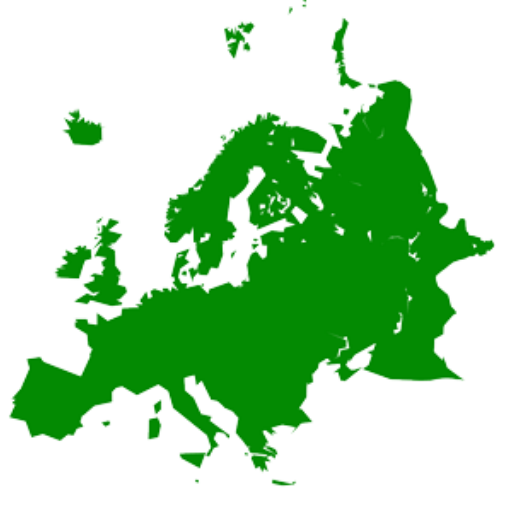 States of Europe
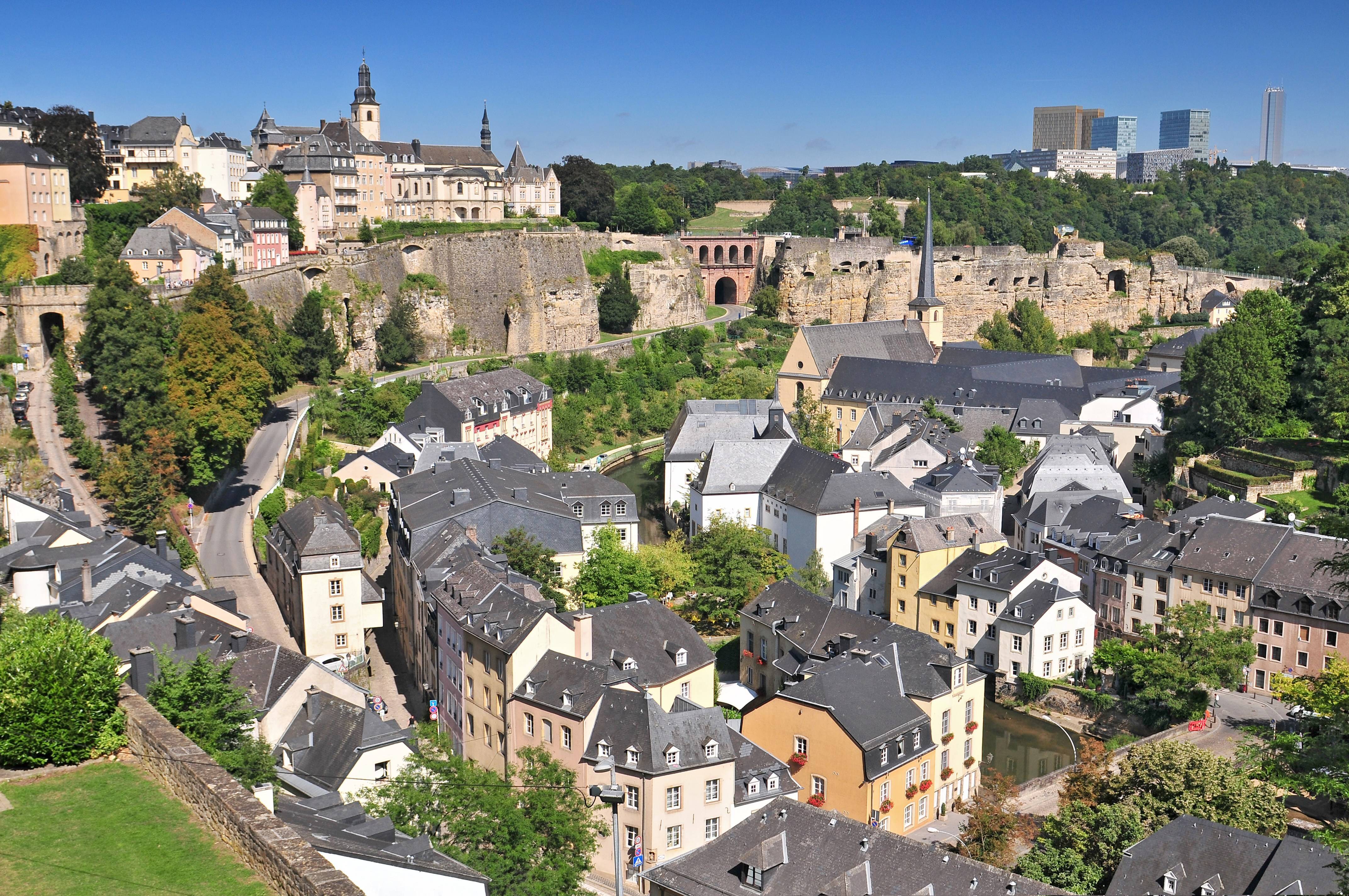

卢森堡是一个高度发达的资本主义国家,也是欧盟和北约创始成员国之一,拥有欧盟多个下设机构,如欧洲法院、欧洲审计院以及欧洲投资银行,被称为继布鲁塞尔和斯特拉斯堡之后的欧盟“第三首都”。同时是高度发达的工业国家,还是欧元区内最重要的私人银行中心,及全球第二大仅次于美国的投资信托中心。金融、广播电视、钢铁是其三大经济支柱产业,该国失业率极低,人均寿命80岁。
卢森堡大公国(卢森堡语:Groussherzogtum Lëtzebuerg[注 1];法语:Grand-Duché de Luxembourg; 德语:Großherzogtum Luxemburg[注 2]),通称卢森堡(卢森堡语:Lëtzebuerg;法语:Luxembourg;德语:Luxemburg),被邻国法国、德国和比利时包围,是一个位于欧洲的内陆国家,也是现今欧洲大陆仅存的大公国,首都卢森堡市。卢森堡是欧盟成员国,因境内有欧洲法院、欧洲审计院、欧洲投资银行等多个欧盟机构被称为继布鲁塞尔和斯特拉斯堡之后的欧盟“第三首都”。
Das Großherzogtum Luxemburg (luxemburgisch Groussherzogtum Lëtzebuerg [ˈgʀəʊsˌhɛχtsoːktuːm ˈlətsəbuəɕ], französisch Grand-Duché de Luxembourg [ɡʁɑ̃ dyʃe də lyksɑ̃buʁ]) ist ein demokratischer Staat in Form einer parlamentarischen Monarchie[1] im Westen Mitteleuropas. Es ist das letzte Großherzog- bzw. Großfürstentum (von einst zwölf) in Europa. Das Land gehört zum mitteldeutschen Sprachraum. Landessprache ist Luxemburgisch, Verwaltungs- und Amtssprachen sind Französisch, Deutsch und Luxemburgisch. Gemeinsam mit seinem Nachbarn Belgien und mit den Niederlanden bildet Luxemburg die Beneluxstaaten.
ルクセンブルク大公国(ルクセンブルクたいこうこく)、通称ルクセンブルクは、西ヨーロッパに位置する立憲君主制国家。首都は国名と同名のルクセンブルク市。隣接国は、南のフランス、西と北のベルギー、東のドイツである。ベルギー、オランダと併せてベネルクスと呼ばれる。
Luxembourg (/ˈlʌksəmbɜːrɡ/ (![]() listen)) (Luxembourgish: Lëtzebuerg [ˈlətsəbuə̯ɕ] (
listen)) (Luxembourgish: Lëtzebuerg [ˈlətsəbuə̯ɕ] (![]() listen); French: Luxembourg ; German: Luxemburg), officially the Grand Duchy of Luxembourg,[note 2] is a small landlocked country in western Europe. It is bordered by Belgium to the west and north, Germany to the east, and France to the south. Its capital, Luxembourg City, together with Brussels and Strasbourg, is one of the three official capitals of the European Union[6] and the seat of the European Court of Justice, the highest judicial authority in the EU. Its culture, people, and languages are highly intertwined with its neighbours, making it essentially a mixture of French and German cultures, as evident by the nation's three official languages: French, German, and the national language, Luxembourgish (sometimes considered a dialect of German). The repeated invasions by Germany, especially in World War II, resulted in the country's strong will for mediation between France and Germany and, among other things, led to the foundation of the European Union.[7]
listen); French: Luxembourg ; German: Luxemburg), officially the Grand Duchy of Luxembourg,[note 2] is a small landlocked country in western Europe. It is bordered by Belgium to the west and north, Germany to the east, and France to the south. Its capital, Luxembourg City, together with Brussels and Strasbourg, is one of the three official capitals of the European Union[6] and the seat of the European Court of Justice, the highest judicial authority in the EU. Its culture, people, and languages are highly intertwined with its neighbours, making it essentially a mixture of French and German cultures, as evident by the nation's three official languages: French, German, and the national language, Luxembourgish (sometimes considered a dialect of German). The repeated invasions by Germany, especially in World War II, resulted in the country's strong will for mediation between France and Germany and, among other things, led to the foundation of the European Union.[7]
With an area of 2,586 square kilometres (998 sq mi), it is one of the smallest sovereign states in Europe.[8] In 2016, Luxembourg had a population of 576,249, which makes it one of the least-populous countries in Europe,[9] but by far the one with the highest population growth rate.[10] Foreigners account for nearly half of Luxembourg's population.[11] As a representative democracy with a constitutional monarch, it is headed by Grand Duke Henri and is the world's only remaining grand duchy. Luxembourg is a developed country, with an advanced economy and one of the world's highest GDP (PPP) per capita. The City of Luxembourg with its old quarters and fortifications was declared a UNESCO World Heritage Site in 1994 due to the exceptional preservation of the vast fortifications and the old city.[12]
The history of Luxembourg is considered to begin in 963, when count Siegfried I acquired a rocky promontory and its Roman-era fortifications known as Lucilinburhuc, ′little castle′, and the surrounding area from the Imperial Abbey of St. Maximin in nearby Trier.[13][14] Siegfried's descendants increased their territory through marriage, war and vassal relations. At the end of the 13th century, the Counts of Luxembourg reigned over a considerable territory. [15] In 1308, Henry VII, Count of Luxembourg became King of the Germans and Holy Roman Emperor. The House of Luxembourg produced four Holy Roman Emperors at the high time of the Middle Ages. In 1354, Charles IV elevated the County to the Duchy of Luxembourg. Since Sigismund had no male heir, the Duchy became part of the Burgundian Circle and then one of the Seventeen Provinces of the Habsburg Netherlands.[16] Over the centuries, the City and Fortress of Luxembourg, of great strategic importance situated between the Kingdom of France and the Habsburg territories, was gradually built up to be one of the most reputed fortifications in Europe. After belonging to both the France of Louis XIV and the Austria of Maria Theresia, Luxembourg became part of the First French Republic and Empire under Napoleon.[17]
The present-day state of Luxembourg first emerged at the Congress of Vienna in 1815. The Grand-Duchy, with its powerful fortress, became an independent state under the personal possession of William I of the Netherlands with a Prussian garrison to guard the city against another invasion from France. [18] In 1839, following the turmoil of the Belgian Revolution, the purely Oil-speaking part of Luxembourg was ceded to Belgium and the Luxembourgish-speaking part (except the Arelerland, the area around Arlon) became what is the present state of Luxembourg. [19]
The steel industry exploiting the Red Lands' rich iron-ore grounds in the beginning of the 20th century drove the country's industrialisation. ArcelorMittal, the world's largest steel producer with headquarters in Luxembourg City, is still a reminder of these times. After the decline of the steel industry in the 1970s, the country focused on establishing itself as a global financial centre and developed into the banking hub it is reputed for. Since the beginning of the 21st century, its governments have focused on developing the country into a knowledge economy, with the founding of the University of Luxembourg and a national space programme, projecting the first involvement in a robotic lunar expedition by 2020.[20]
Luxembourg is a founding member of the European Union, OECD, United Nations, NATO, and Benelux. The city of Luxembourg, which is the country's capital and largest city, is the seat of several institutions and agencies of the EU. Luxembourg served on the United Nations Security Council for the years 2013 and 2014, which was a first in the country's history.[21] In 2016 Luxembourgish citizens had visa-free or visa-on-arrival access to 172 countries and territories, ranking the Luxembourgish passport 15th in the world, tied with countries such as Canada and Switzerland.[22]
Le Luxembourg, en forme longue le Grand-Duché de Luxembourg2,b,c ou le grand-duché de Luxembourgd, en luxembourgeois Lëtzebuerg et Groussherzogtum Lëtzebuerg, en allemand Luxemburg et Großherzogtum Luxemburg, est un pays d'Europe de l'Ouest sans accès à la mere Il est bordé par la Belgique à l'ouest et au nord, l'Allemagne à l'est, et la France au sud. Il comprend deux régions principales : l'Oesling au nord, qui est une partie du massif des Ardennes, et le Gutland au sud, prolongement de la Lorraine au sens géologique du terme. Le Luxembourg compte 602 005 habitants au 1er janvier 20181, et s'étend sur une superficie de 2 586 km2, faisant de lui l'une des plus petites nations souveraines d'Europe.
Le Luxembourg est une démocratie représentative et une monarchie constitutionnelle avec un grand-duc pour chef d'État, faisant du pays le seul grand-duché encore existant. Son économie dynamique en fait un des pays les plus riches et des plus prospères du monde, avec le PIB par habitant le plus élevé du monde selon le FMI en 2014. L'économie est principalement centrée sur les activités financières (environ la moitié du produit intérieur brut), favorisée par une fiscalité attractive voire dérisoire dans certains domaines (quasi-exonération d'impôts pour les bénéfices issus de l'exploitation de brevets ou de logiciels). La localisation centrale du territoire luxembourgeois en Europe a historiquement fait de lui un lieu d'une grande importance stratégique pour de nombreuses puissances, depuis sa fondation en tant que fortin romain7, son accueil d'un château franc durant le Haut Moyen Âge, et son rôle de bastion pour le chemin des Espagnols entre les XVIe et XVIIe siècles.
Le Luxembourg est le plus petit membre fondateur de l'Union européenne, de la zone euro, de l'OTAN, de l'OCDE, de l'ONU, de l'OSCE, du Conseil de l'Europe8,9,10,11 et du Benelux, reflétant son consensus politique en faveur de l'intégration économique, politique et militaire. La ville de Luxembourg, sa capitale et sa plus grande ville, est le siège de plusieurs établissements et institutions de l'UE. En 2012, le Luxembourg a été élu pour la première fois de son histoire à un siège temporaire au Conseil de sécurité des Nations unies. En raison de sa position géographique, la culture luxembourgeoise est une fusion de l'Europe germanique et romane, intégrant chacune des deux. De ce fait, le Luxembourg est un pays trilingue : le luxembourgeois, le français et l'allemand sont les trois langues officielles et, depuis 1984, le luxembourgeois a légalement le statut de « langue nationale »12.
Il Granducato di Lussemburgo (in francese: le Grand-Duché de Luxembourg; in lussemburghese: Groussherzogtum Lëtzebuerg; in tedesco: Großherzogtum Luxemburg) è un paese membro dell'Unione europea situato tra Germania, Francia e Belgio. È uno stato senza sbocco sul mare.
Membro fondatore dell'Unione europea, della NATO, del Benelux e delle Nazioni Unite, la sua capitale, l'omonima città di Lussemburgo, è sede di numerose istituzioni e agenzie europee oltre ad essere uno snodo finanziario di primaria importanza.
È l'unico granducato rimasto al mondo.
Luxemburgo, oficialmente denominado Gran Ducado de Luxemburgo (luxemburgués: Groussherzogtum Lëtzebuerg, francés: Grand-Duché de Luxembourg, alemán: Großherzogtum Luxemburg), es un pequeño país de Europa Central que forma parte de la Unión Europea. Se trata de un Estado sin litoral, rodeado por Francia, Alemania y Bélgica. Luxemburgo cuenta con una población de medio millón de habitantes sobre un área de 2586 kilómetros cuadrados.1
El gobierno de Luxemburgo es una monarquía constitucional y parlamentaria, siendo el único gran ducado soberano en la actualidad. El Estado tiene una economía altamente desarrollada, con el mayor producto interior bruto por cápita del mundo de acuerdo al Banco Mundial, y el segundo de acuerdo al Fondo Monetario Internacional.
Luxemburgo es miembro de la Unión Europea, la Organización del Tratado del Atlántico Norte, la Organización para la Cooperación y el Desarrollo Económico, las Naciones Unidas y el Benelux, reflejando la orientación política a favor de la integración económica, política y militar. Su capital, Luxemburgo, es sede de numerosas instituciones y agencias de la Unión Europea.
Luxemburgo posee culturas y tradiciones diversas por encontrarse entre la Europa romana y la Europa germánica. El país tiene tres lenguas oficiales: alemán, francés y luxemburgués. La localidad Schengen, que dio su nombre al espacio de Schengen, está ubicada en Luxemburgo.
Люксембу́рг (люксемб. Lëtzebuerg), официально Вели́кое Ге́рцогство Люксембу́рг (люксемб. Groussherzogtum Lëtzebuerg, фр. Grand-Duché de Luxembourg, нем. Großherzogtum Luxemburg) — государство (великое герцогство) в Западной Европе. Граничит с Бельгией на севере, на западе и на юге с Францией, на востоке с Германией, не имеет выхода к морю. Название происходит от древневерхненемецкого «lucilinburch» — «малый город». Общая площадь Люксембурга составляет 2586,4 км², что делает его одним из самых маленьких суверенных государств в Европе[5]. Население на 1 января 2018 года составляет 602 005 человек[2].
Член Европейского союза с 1957 года, также является членом НАТО, ОЭСР и ООН. Вместе с Бельгией и Нидерландами входит в состав Бенилюкса.
 Eurovision Song Contest,ESC
 Finland

 Geography

 Geography
 *World's Most Livable Cities

 International cities
 *European Capital of Culture

 International cities
 *World Design Capital
 Olympic Summer Games

 Important port

赫尔辛基(芬兰语:Helsinki [ˈhelsiŋki] ![]() 聆听;瑞典语:Helsingfors [ˌhɛlsɪŋˈfɔʂː]
聆听;瑞典语:Helsingfors [ˌhɛlsɪŋˈfɔʂː] ![]() 聆听),是芬兰的首都以及全国最大城市,芬兰语和瑞典语同为官方语言。赫尔辛基位于新地区,芬兰南端的芬兰湾岸边。在2017年底,赫尔辛基人口为643,272人[4]。所谓“大赫尔辛基”是由赫尔辛基和埃斯波、万塔、考尼艾宁四个城市一起组成的首都地区及周边市镇所组成的都会区,在2014年底的统计中有1,420,284人[5]。
聆听),是芬兰的首都以及全国最大城市,芬兰语和瑞典语同为官方语言。赫尔辛基位于新地区,芬兰南端的芬兰湾岸边。在2017年底,赫尔辛基人口为643,272人[4]。所谓“大赫尔辛基”是由赫尔辛基和埃斯波、万塔、考尼艾宁四个城市一起组成的首都地区及周边市镇所组成的都会区,在2014年底的统计中有1,420,284人[5]。
赫尔辛基在爱沙尼亚塔林北部约80公里处,距离西南的瑞典斯德哥尔摩约400公里,距离东边的俄罗斯圣彼得堡约300公里。这三座城市与赫尔辛基在历史上有着密切联系。
Helsinki (finnisch [ˈhɛlsiŋki], schwedisch [hɛlsɪŋˈfɔrs]) ist die Hauptstadt Finnlands. Sie liegt in der Landschaft Uusimaa im Süden des Landes an der Küste des Finnischen Meerbusens und ist die nördlichste Hauptstadt eines Mitgliedstaates der EU. Mit 648.042 Einwohnern (Stand 31. Dezember 2018) ist Helsinki mit Abstand die größte Stadt Finnlands und drittgrößte Stadt der Nordischen Länder, nach Stockholm und Oslo.
Zusammen mit den Nachbarstädten Espoo, Vantaa und Kauniainen bildet es die sogenannte Hauptstadtregion, einen Ballungsraum mit etwa 1,49 Millionen Einwohnern und damit den nördlichsten Ballungsraum der Welt mit über einer Million Einwohnern.[3] Helsinki ist das politische, wirtschaftliche, wissenschaftliche und kulturelle Zentrum Finnlands. Rund sechs Prozent der Einwohner Helsinkis sind schwedischsprachig, offiziell ist die Stadt zweisprachig.
Helsinki liegt 80 km nördlich von Tallinn, Estland, 400 km östlich von Stockholm, Schweden, und 300 km westlich von Sankt Petersburg, Russland. Es hat enge historische Verbindungen zu diesen drei Städten.
Die Stadt wurde, unter dem schwedischen Namen Helsinge fors[4], im Jahr 1550 während der Zugehörigkeit Finnlands zu Schweden gegründet, blieb aber lange unbedeutend. Kurz nachdem Finnland unter russische Herrschaft gekommen war, wurde Helsinki 1812 zur Hauptstadt des neugegründeten Großfürstentums Finnland bestimmt und löste so Turku als wichtigste Stadt des Landes ab. Der offizielle Gebrauch des finnisierten Namens Helsinki begann erst in dieser Zeit.[5]
Seit 1917 ist Helsinki Hauptstadt des unabhängigen Finnlands.
ヘルシンキ (フィンランド語: Helsinki,フィンランド語発音: [ˈhe̞l.siŋ.k̟i]) ![]() listen; スウェーデン語: Helsingfors,
listen; スウェーデン語: Helsingfors, ![]() listen)は、フィンランドの首都で同国最大の都市である。また、バルト海東部のフィンランド湾に面した同国南部のウーシマー県の県庁所在地である。人口は616,042人(2013年2月28日現在)[4]、都市的地域の人口は 1,176,976人(2012年12月31日現在)[5]、ヘルシンキ都市圏である大ヘルシンキの人口は約140万人でフィンランドではもっとも人口の多い自治体と都市域を形成している。
listen)は、フィンランドの首都で同国最大の都市である。また、バルト海東部のフィンランド湾に面した同国南部のウーシマー県の県庁所在地である。人口は616,042人(2013年2月28日現在)[4]、都市的地域の人口は 1,176,976人(2012年12月31日現在)[5]、ヘルシンキ都市圏である大ヘルシンキの人口は約140万人でフィンランドではもっとも人口の多い自治体と都市域を形成している。
ヘルシンキは、ロシアの旧都サンクトペテルブルク、エストニアの首都タリンと同じく、フィンランド湾に面する主要都市の一つである。ヘルシンキからの距離は、東のサンクトペテルブルクまでは300キロメートル (190 mi)、南のタリンまでは85キロメートル (53 mi)である[6]。 なお、西に400キロメートル (250 mi)の距離に位置するバルト海の対岸のスウェーデンの首都ストックホルムも加え、これらの都市とヘルシンキは歴史的に密接な関係にあった。
ヘルシンキ都市圏には核となるヘルシンキの都市的地域とエスポーやヴァンター、カウニアイネン、周辺のベッドタウンが含まれる[7]。ヘルシンキは100万人以上が住む都市圏としては最北に位置する都市圏で欧州連合加盟国の首都としては最北に位置する都市であり、フィンランドの政治や教育、金融、文化、調査センターなど様々な分野の中心都市で、ヨーロッパでも最北の大都市である。
フィンランドで事業を行う外国企業の70%はヘルシンキ地域で事業を行っており[8]、2009年に、2012年の世界デザイン首都[9]に国際インダストリアルデザイン団体協議会により選ばれ、僅差でアイントホーフェンを破っている。
エコノミスト・インテリジェンス・ユニットは2012年8月に住むのに適した都市の調査で、ヘルシンキは総合で8位にランクした[10]。2011年、モノクルマガジンの調査Liveable Cities Index 2011でヘルシンキは最も住むのに適した都市に位置している[11]。
Helsinki (/ˈhɛlsɪŋki/ HEL-sink-ee or /hɛlˈsɪŋki/ (![]() listen) hel-SINK-ee;[7][8] Finnish: [ˈhelsiŋki] (
listen) hel-SINK-ee;[7][8] Finnish: [ˈhelsiŋki] (![]() listen); Swedish: Helsingfors [hɛlsɪŋˈfɔʂː] (
listen); Swedish: Helsingfors [hɛlsɪŋˈfɔʂː] (![]() listen), Finland Swedish: [helsiŋˈforsː] (
listen), Finland Swedish: [helsiŋˈforsː] (![]() listen)) is the capital, primate and most populous city of Finland. Located on the shore of the Gulf of Finland, it is the seat of the region of Uusimaa in southern Finland, and has a population of 650,058.[9] The city's urban area has a population of 1,268,296,[10] making it by far the most populous urban area in Finland as well as the country's most important center for politics, education, finance, culture, and research; while Tampere in the Pirkanmaa region, located 179 kilometres (111 mi) to the north from Helsinki, is the second largest urban area in Finland. Helsinki is located 80 kilometres (50 mi) north of Tallinn, Estonia, 400 km (250 mi) east of Stockholm, Sweden, and 300 km (190 mi) west of Saint Petersburg, Russia. It has close historical ties with these three cities.
listen)) is the capital, primate and most populous city of Finland. Located on the shore of the Gulf of Finland, it is the seat of the region of Uusimaa in southern Finland, and has a population of 650,058.[9] The city's urban area has a population of 1,268,296,[10] making it by far the most populous urban area in Finland as well as the country's most important center for politics, education, finance, culture, and research; while Tampere in the Pirkanmaa region, located 179 kilometres (111 mi) to the north from Helsinki, is the second largest urban area in Finland. Helsinki is located 80 kilometres (50 mi) north of Tallinn, Estonia, 400 km (250 mi) east of Stockholm, Sweden, and 300 km (190 mi) west of Saint Petersburg, Russia. It has close historical ties with these three cities.
Together with the cities of Espoo, Vantaa, and Kauniainen, and surrounding commuter towns,[11] Helsinki forms the Greater Helsinki metropolitan area, which has a population of nearly 1.5 million. Often considered to be Finland's only metropolis, it is the world's northernmost metro area with over one million people as well as the northernmost capital of an EU member state. After Stockholm and Oslo, Helsinki is the third largest municipality in the Nordic countries. Finnish and Swedish are both official languages. The city is served by the international Helsinki Airport, located in the neighboring city of Vantaa, with frequent service to many destinations in Europe and Asia.
Helsinki was the World Design Capital for 2012,[12] the venue for the 1952 Summer Olympics, and the host of the 52nd Eurovision Song Contest in 2007.
Helsinki has one of the world's highest urban standards of living. In 2011, the British magazine Monocle ranked Helsinki the world's most liveable city in its liveable cities index.[13] In the Economist Intelligence Unit's 2016 liveability survey, Helsinki was ranked ninth among 140 cities.[14]
Helsinki (prononcé /ɛl.siŋ.ˈki/ ; Helsinki /ˈhɛl.siŋ.ki/ Écouter en finnois et Helsingfors /hɛl.sɪŋ.ˈfɔrs/ Écouter en suédois), est la capitale et la plus grande ville de la Finlande avec 642 045 habitants4 dans la commune et 1 456 619 dans le Grand Helsinki. Helsinki est la capitale la plus septentrionale du monde après Reykjavik, capitale de l'Islande. La ville a la plus forte population immigrée de tout le pays. Il y a plus de 130 nationalités résidant dans la ville d'Helsinki. Elle s'étale sur une presqu'île entourée d'un grand nombre d'îles et est fortement caractérisée par la présence de l'eau. Helsinki est un port marchand ouvert sur le golfe de Finlande.
Ses habitants sont appelés les Helsinkiens ; en finnois Helsinkiläiset, en suédois Helsingforsare.
Helsinki (pronuncia italiana [ˈɛlsiŋki][3]; in finlandese [ˈhelsiŋki] ; in svedese , pronuncia [hɛlsɪŋˈfɔrs]) è la capitale e la città più grande della Finlandia, con 648.650 abitanti (dato 2018)[4], situata nella regione dell'Uusimaa. La città è bilingue, le lingue ufficiali sono il finlandese e lo svedese.
Helsinki è geograficamente situata nella parte meridionale del Paese sulle rive del golfo di Finlandia, parte del mar Baltico, di fronte alla capitale dell'Estonia, Tallinn, e si estende su più isole.
L'area metropolitana di Helsinki include l'area urbana della città, Espoo, Vantaa, Kauniainen e paesi limitrofi[5]. È l'area metropolitana più a nord nel mondo, con il suo milione di abitanti è la città e capitale più a nord degli Stati membri dell'Unione europea.
A Helsinki hanno sede il parlamento, il governo, sette università e le sedi dei vescovi evangelico-luterani, cattolici e russo-ortodossi.
Nello slang di Helsinki la città è chiamata Stadi (per il vocabolo svedese stad, "città") o Hesa (forma abbraviata di "Helsinki" con il suffisso gergale -sa), lasciando intendere che chi usa il termine Stadi sia nativo della città[6]. Helsset è il termine usato dai sami del Nord per Helsinki.
Helsinki (en finlandés: Helsinki ![]() [ˈhɛlsiŋki] (?·i); en sueco: Helsingfors
[ˈhɛlsiŋki] (?·i); en sueco: Helsingfors ![]() [hɛlsɪŋˈfɔrs] (?·i)) es la capital y la ciudad más grande de Finlandia. Está situada en la costa sur del país, a la orilla del golfo de Finlandia. Helsinki forma parte de la región de Uusimaa.
[hɛlsɪŋˈfɔrs] (?·i)) es la capital y la ciudad más grande de Finlandia. Está situada en la costa sur del país, a la orilla del golfo de Finlandia. Helsinki forma parte de la región de Uusimaa.
Las influencias del Este y el Oeste se encuentran presentes en la vida diaria de Helsinki. Arquitectura, gastronomía, diseño, costumbres y hasta el argot local de las calles atestiguan un pasado bajo dominio ruso y sueco.
Situada junto al mar Báltico, la línea de costa de Helsinki se extiende unos 100 kilómetros, y acoge 300 islas frente al continente. 665 281 personas viven en la propia ciudad de Helsinki (Enero 2020)145 y el área metropolitana (municipios de Helsinki, Espoo, Vantaa y Kauniainen) tiene una población un millón de habitantes en total. Incluyendo otros municipios cercanos la población es de alrededor de 1,4 millones de personas.2 Uno de cada cuatro finlandeses vive en Helsinki.
Helsinki es el mayor centro político, educativo, financiero, cultural y de investigación, así como una de las ciudades más importantes del norte de Europa. Aproximadamente el 70 % de las empresas extranjeras que operan en Finlandia se han establecido en la región de Helsinki.6
Helsinki fue elegida Capital Mundial del Diseño para el año 2012,7 sede de los Juegos Olímpicos en 1952 y del 52º Festival de Eurovisión en 2007. Helsinki es conocida a nivel mundial por su gran diseño, el cual es bien evidente en sus calles, comercios y edificios, formando parte de la red de ciudades creativas por la UNESCO desde 2014.8
En la edición de agosto de 2012, el estudio del Economist Intelligence Unit colocó en octavo lugar a Helsinki en el ranking general de las mejores ciudades para vivir a nivel mundial.9 En 2011 la revista Monocle estableció a la ciudad de Helsinki como la mejor ciudad para vivir y desarrollarse en el mundo entero.
Хе́льсинки (фин. Helsinki, швед. Helsingfors , до 1926 года в русском языке официально использовалось шведское название Гельсингфорс[3]) — столица и крупнейший город Финляндии, административный центр провинции Уусимаа (Нюланд). Расположен на юге страны, на берегу Финского залива Балтийского моря. Население — 655 281 человека (31.1.2020)[4]. Иностранные граждане составляют около 10 % населения города.
Хельсинки вместе с городами-спутниками Вантаа (Ванда), Эспоо (Эсбy[5]) и Кауниайнен (Гранкулла) образует столичный регион с населением более миллиона человек. Население Большого Хельсинки, территория которого включает 12 коммун, превышает 1,3 миллиона человек[2]. Хельсинки является центром бизнеса, образования, культуры и науки в Финляндии. В Большом Хельсинки расположены 8 университетов и 6 технологических парков[6]. 70 % иностранных компаний, работающих в Финляндии, расположены в столичном регионе[6]. Миграция населения из провинции делает Хельсинки одним из самых быстрорастущих муниципальных районов в Европе. Главным международным авиаузлом в Финляндии является Аэропорт Хельсинки-Вантаа, расположенный в 20 километрах от центра столицы и осуществляющий прямые перелёты по всему миру. Путь от Хельсинки до Таллина занимает 1,5 часа по морю и 18 минут на вертолёте (расстояние составляет 80 км). В два других крупных города, Тампере и Турку, можно попасть за 1,5—2 часа на поезде и 1,5—2,5 часа на машине. На скоростном поезде «Аллегро» до Санкт-Петербурга можно добраться за 3,5 часа (390 км).
В 2014 году в рейтинге 25 лучших городов мира, составленном британским журналом Monocle[en], Хельсинки занял пятое место (на первом месте — Копенгаген)[7]. В 2011 году в опубликованном международной консалтинговой компанией Mercer рейтинге наиболее безопасных городов мира Хельсинки разделил 2—4 места с Цюрихом и Берном (на первом месте — Люксембург)[8][9]. В начале 2012 года газета The New York Times в ежегодно публикуемом ею списке мест нашей планеты, которые стоит посетить в наступившем году, поставила Хельсинки на второе место (на первом месте — Панама, на третьем — Мьянма)[10][11].
По опросам общественного мнения в 2012 году Хельсинки занимает четвёртое место по уровню привлекательности для проживания среди финских граждан[12].
В 2013 году по расчетам консалтингового агентства ECA International Хельсинки занял двадцатое место в рейтинге самых дорогих городов планеты (первое место — Осло)[13], а международная деловая газета Financial Times представила ряд районов финской столицы в лучшем свете как мест для вложений в недвижимость[14].
День города отмечается ежегодно 12 июня[15].

 Architecture
 Eurovision Song Contest,ESC

 History

 International cities

 International cities
 *European Capital of Culture

 Medieval cities in Europe
 Silk road
 Turkey

 Cities founded by the Romans

 World Heritage


伊斯坦布尔(土耳其语:İstanbul [isˈtanbuɫ] ![]() 聆听)是土耳其最大城市,亦是该国的经济、文化和历史中心。它坐落于土耳其西北部的博斯普鲁斯海峡之滨,位于马尔马拉海和黑海之间,横跨欧亚大陆,经济和历史中心位于欧洲一侧,有三分之一人口居住于亚洲一侧[3]。其人口达到1440万,为全欧洲最大的城市群,亦是中东最大和全球第六大城市[2][4]。伊斯坦布尔全市辖区面积5,343平方千米(2,063平方英里),其覆盖范围同伊斯坦布尔省相同,亦是该省的行政中心[c]。亦是世界上唯一横跨两大洲的城市。
聆听)是土耳其最大城市,亦是该国的经济、文化和历史中心。它坐落于土耳其西北部的博斯普鲁斯海峡之滨,位于马尔马拉海和黑海之间,横跨欧亚大陆,经济和历史中心位于欧洲一侧,有三分之一人口居住于亚洲一侧[3]。其人口达到1440万,为全欧洲最大的城市群,亦是中东最大和全球第六大城市[2][4]。伊斯坦布尔全市辖区面积5,343平方千米(2,063平方英里),其覆盖范围同伊斯坦布尔省相同,亦是该省的行政中心[c]。亦是世界上唯一横跨两大洲的城市。
公元前660年左右,该市以“拜占庭”之名建立于萨拉基里奥角,并在此后逐渐发展为历史上最为重要的城市之一。公元330年该市重建为君士坦丁堡([Κωνσταντινούπολις Konstantinoúpolis] 错误:{{lang-xx}}:文本有斜体标记(帮助);拉丁语:Constantinopolis)或新罗马([Νέα Ῥώμη, Nea Romē] 错误:{{lang-xx}}:文本有斜体标记(帮助);拉丁语:Nova Roma),并在此后的近十六个世纪内先后成为罗马帝国(330年–1204年及1261年–1453年)、拉丁帝国(1204年–1261年)和奥斯曼帝国(1453年–1922年)的帝国首都[5]。在罗马和拜占庭帝国时代,它对基督教的发展起到了重要的作用,而在1453年奥斯曼帝国征服该城之后,它成为了伊斯兰教的中心和奥斯曼帝国哈里发的驻地[6]。
伊斯坦布尔是古丝绸之路的途经地[7],也是欧洲和中东的铁路网络之间、黑海和地中海间海路的必经之地,使得伊斯坦布尔的战略地位十分重要,由此也哺育了兼收并蓄的人口和文化,虽然在1923年共和国成立之后这一状况略不如前。在战间期伊斯坦布尔 未能成为新首都,受到忽视,但此后其影响力逐步恢复。自1950年代以来,该市的人口已翻了十倍,来自安那托利亚各地的人口涌入,城市的界限也为此逐渐扩张[8][9]。20世纪末艺术节开始得到兴办,而随着基础设施的改善,复杂的交通网络也由此建立起来。
2012年,在当选欧洲文化之都两年之后,近1160万外国游客造访伊斯坦布尔 ,使其成为世界第五受欢迎的旅游目的地[10]。该市最重要的景点仍是其历史城区,部分被列为联合国教科文组织世界遗产,而位于贝伊奥卢区的天然港金角湾则是其文化和娱乐的中心。伊斯坦布尔还被认为是一个全球城市[11],亦是全球发展速度最快的都市经济区之一[12]。诸多土耳其公司及媒体将总部设于此,全市国内生产总值超过全国的四分之一[13]。伊斯坦布尔希望借助其复苏和快速扩张的契机,在二十年内五次申请举办夏季奥林匹克运动会[14]。
Istanbul (türkisch İstanbul, von griechisch εἰς τὴν πόλιν, eis tḕn pólin, „in die Stadt“: siehe unten), früher Konstantinopel, ist die bevölkerungsreichste Stadt der Türkei und deren Zentrum für Kultur, Handel, Finanzen und Medien. Mit rund 14,4 Millionen Einwohnern nahm die Metropolregion 2016 den 15.[5] Platz unter den größten Metropolregionen der Welt ein. Mit jährlich knapp zwölf Millionen Touristen aus dem Ausland ist Istanbul überdies die Stadt mit der achtgrößten Besucherzahl der Welt.[6] Die Stadt liegt am Nordufer des Marmarameeres auf beiden Seiten des Bosporus, also sowohl im europäischen Thrakien als auch im asiatischen Anatolien. Aufgrund ihrer weltweit einzigartigen Transitlage zwischen zwei Kontinenten und zwei Meeresgebieten, dem Schwarzen und dem Mittelmeer, verzeichnet sie einen bedeutenden Schiffsverkehr und verfügt über zwei große Flughäfen sowie zwei zentrale Kopf- und zahlreiche Fernbusbahnhöfe. Das Projekt Marmaray verbindet beide Hälften der Stadt per Eisenbahn und künftig die Kopfbahnhöfe an den Eisenbahnverkehr des jeweils anderen Kontinents. Istanbul ist daher einer der wichtigsten Knotenpunkte für Verkehr und Logistik auf internationaler wie nationaler Ebene.
Im Jahr 660 v. Chr. unter dem Namen Byzantion gegründet, kann die Stadt auf eine 2600-jährige Geschichte zurückblicken. Fast 1600 Jahre lang diente sie nacheinander dem Römischen, dem Byzantinischen und dem Osmanischen Reich als Hauptstadt. Als Sitz des ökumenischen Patriarchen und – bis 1924 – des osmanischen Kalifats war Istanbul zudem jahrhundertelang ein bedeutendes Zentrum des orthodoxen Christentums und des sunnitischen Islams.
Das Stadtbild ist von Bauten der griechisch-römischen Antike, des mittelalterlichen Byzanz sowie der neuzeitlichen und modernen Türkei geprägt. Paläste gehören ebenso dazu wie zahlreiche Moscheen, Cemevleri, Kirchen und Synagogen. Aufgrund ihrer Einzigartigkeit wurde die historische Altstadt von der UNESCO zum Weltkulturerbe erklärt. 2010 war Istanbul Kulturhauptstadt Europas.
イスタンブール(トルコ語: İstanbul [isˈtanbul]、英語: Istanbul [ˌɪstænˈbuːl]、ラテン語: Constantinopolis コーンスタンティーノポリス、ギリシア語: Κωνσταντινούπολις コーンスタンティヌーポリス /現代ギリシア語 Κωνσταντινούπολι コンスタンディヌーポリ)は、トルコ最大の都市であり、経済・文化・歴史の中心地。トルコ語の発音に準じて「イスタンブル」と表記される場合もある。
Istanbul (UK: /ˌɪstænˈbʊl/, /-ˈbuːl/ or US: /-stɑːn-/ or /ˈɪstənbʊl/;[6][7][8] Turkish: İstanbul [isˈtanbuɫ] (![]() listen)), historically known as Byzantium and Constantinople, is the most populous city in Turkey and the country's economic, cultural, and historic center. Istanbul is a transcontinental city in Eurasia, straddling the Bosporus strait (which separates Europe and Asia) between the Sea of Marmara and the Black Sea. Its commercial and historical center lies on the European side and about a third of its population lives on the Asian side.[9] The city is the administrative center of the Istanbul Metropolitan Municipality (coterminous with Istanbul Province), both hosting a population of around 15 million residents. [3] Istanbul is one of the world's most populous cities and ranks as the world's 5th-largest city proper and the largest European city. Istanbul is viewed as a bridge between the East and West.
listen)), historically known as Byzantium and Constantinople, is the most populous city in Turkey and the country's economic, cultural, and historic center. Istanbul is a transcontinental city in Eurasia, straddling the Bosporus strait (which separates Europe and Asia) between the Sea of Marmara and the Black Sea. Its commercial and historical center lies on the European side and about a third of its population lives on the Asian side.[9] The city is the administrative center of the Istanbul Metropolitan Municipality (coterminous with Istanbul Province), both hosting a population of around 15 million residents. [3] Istanbul is one of the world's most populous cities and ranks as the world's 5th-largest city proper and the largest European city. Istanbul is viewed as a bridge between the East and West.
Founded under the name of Byzantion (Βυζάντιον) on the Sarayburnu promontory around 660 BCE, the city grew in size and influence, having become one of the most important cities in history. After its reestablishment as Constantinople in 330 CE, it served as an imperial capital for almost 16 centuries, during the Roman/Byzantine (330–1204 and 1261–1453), the Latin (1204–1261), and the Ottoman (1453–1922) empires.[10] It was instrumental in the advancement of Christianity during Roman and Byzantine times, before the Ottomans conquered the city in 1453 CE and transformed it into an Islamic stronghold and the seat of the Ottoman Caliphate.[11]
Istanbul's strategic position on the historic Silk Road,[12] rail networks to Europe and the Middle East, and the only sea route between the Black Sea and the Mediterranean have produced a cosmopolitan populace. While Ankara was chosen instead as the new Turkish capital after the Turkish War of Independence, the city has maintained its prominence in geopolitical and cultural affairs. The population of the city has increased tenfold since the 1950s, as migrants from across Anatolia have moved in and city limits have expanded to accommodate them.[13][14] Arts, music, film, and cultural festivals were established towards the end of the 20th century and continue to be hosted by the city today. Infrastructure improvements have produced a complex transportation network in the city.
Approximately 12.56 million foreign visitors arrived in Istanbul in 2015, five years after it was named a European Capital of Culture, making the city the world's fifth most popular tourist destination.[15] The city's biggest attraction is its historic center, partially listed as a UNESCO World Heritage Site, and its cultural and entertainment hub can be found across the city's natural harbor, the Golden Horn, in the Beyoğlu district. Considered a global city,[16] Istanbul has one of the fastest-growing metropolitan economies in the world.[17] It hosts the headquarters of many Turkish companies and media outlets and accounts for more than a quarter of the country's gross domestic product.[18] Hoping to capitalize on its revitalization and rapid expansion, Istanbul has bid for the Summer Olympics five times in twenty years.[19]
Istanbul ou Istamboul2 (en turc : İstanbul3), appelé officiellement jusqu'en 1930 et historiquement Constantinople, est la plus grande ville et métropole de Turquie et la préfecture de la province homonyme, dont elle occupe environ 50 % de la superficie mais plus de 97 % de la population. Quatre zones historiques de la ville sont inscrites sur la liste du patrimoine mondial de l'Unesco depuis 1985. Istanbul est le principal centre financier, commercial et industriel de la Turquie mais aussi la capitale culturelle du pays. La population de l'ensemble de l'agglomération stambouliote est évaluée à 15 millions d'habitants en 20144,5 ce qui en fait l'une des plus grandes mégapoles du monde. Forte d'un héritage culturel et historique important, la ville cosmopolite est un haut lieu du tourisme.
Située de part et d’autre du détroit du Bosphore — donc à cheval sur deux continents, l’Europe et l’Asie — Istanbul est généralement considérée comme européenne parce que la ville historique est située sur la rive occidentale du détroit.
Elle est la plus grande agglomération du pays avec plus de 15 millions d'habitants et l'une des plus grandes agglomérations d'Europe. Elle constitue aussi le principal pôle économique de la Turquie.
Appelée officiellement İstanbul depuis le 28 mars 1930, elle a porté d'autres noms durant son histoire (encore parfois utilisés selon les contextes) notamment : « Byzance », au moment de sa fondation ; puis « Constantinople » (à partir du 11 mai 330 en l'honneur de l'empereur romain Constantin Ier).
Appelée aussi la « Deuxième Rome », Istanbul appartint d'abord à la Thrace, puis à l’Empire romain dont elle fut la seconde capitale après 395 (devenu l'Empire romain d'orient et appelé au XVIe siècle « byzantin » par Hieronymus Wolf6), ensuite à l’Empire ottoman depuis le 29 mai 1453, et enfin, juste après la chute de celui-ci le 10 août 1920, à la République de Turquie, dont elle fut capitale jusqu'au 13 octobre 1923, lorsque cette fonction administrative fut transférée à Ankara.
Les anciens noms de la ville, Byzance puis Constantinople, témoignent de cette longue histoire. Seules quelques autres grandes villes ont eu trois noms au cours de leur histoire. Du point de vue historique, il est possible de considérer qu'avec Athènes et Rome, Constantinople (Istanbul) est l'une des trois capitales antiques les plus importantes.
Les habitants de la Byzance antique étaient appelés Byzantiotes et ceux de Constantinople, les Constantinopolitains ou les Politains. Par contre, aucun citoyen de l'Empire romain d'orient ne s'est jamais appelé Byzantin : ils se définissaient comme « Romains » et lorsqu'ils sont devenus sujets de l'Empire ottoman, celui-ci les a organisés dans le milliyet de Rum. Les habitants d’Istanbul sont les Stambouliotes ou les Istanbuliotes7.
La « Sublime Porte » ou simplement « la Porte » étaient les expressions qui désignaient le pouvoir politique ottoman s'il s'agissait du gouvernement ou « le Palais » s'il s'agissait du sultan.
Istanbul (in turco İstanbul, pronuncia [istan'buɫ]), storicamente conosciuta come Bisanzio (in greco antico: Βυζάντιον, Byzàntion; in latino: Byzantium), Costantinopoli (in latino: Constantinopolis; in greco antico: Κωνσταντινούπολις, Konstantinoupolis; in turco ottomano قسطنطينيه Kostantîniyye) o Nuova Roma (in latino: Nova Roma; in greco antico: Νέα Ῥώμη, Néa Rṓmē), è la città capoluogo della provincia omonima e il principale centro industriale, finanziario e culturale della Turchia.
Con una popolazione di circa 15 000 000 di abitanti,[2] Istanbul (considerando però anche i quartieri asiatici) è il secondo centro municipale più popoloso d'Europa (sesto nel mondo) davanti a Londra e dietro Mosca.
Istanbul è una megalopoli situata nel nord-ovest del paese, la quale si estende lungo lo stretto del Bosforo, alla cui estremità meridionale si situa il porto naturale del Corno d'Oro, e lungo la sponda settentrionale del Mar di Marmara. La città, divisa dal Bosforo, si estende sia in Europa (Tracia) sia in Asia (Anatolia), risultando l'unica metropoli al mondo appartenente a due continenti. Istanbul è considerata una città globale.
Nel corso della sua lunga storia, la città (chiamata Bisanzio fino al 330, poi Costantinopoli sino al 1453, Istanbul o Costantinopoli sino al 1930, e da allora in poi solo Istanbul) è stata la capitale:
- dell'Impero romano (330-395);
- dell'Impero bizantino (395-1204 e 1261-1453);
- dell'Impero latino (1204-1261);
- dell'Impero ottomano (1453-1922).
Conosciuta anche con l'appellativo di "seconda Roma", è stata fino alla conquista ottomana nel 1453 una tra le più grandi città della cristianità, divenendo in seguito per quasi cinquecento anni la capitale di uno dei più grandi imperi della storia e crocevia di culture. Quando è stata proclamata la Repubblica di Turchia, il 29 ottobre 1923, Istanbul fu considerata ormai troppo vulnerabile, potendo finire sotto tiro delle marine militari che avevano dimostrato bellamente di poter violare gli stretti durante la Prima guerra mondiale, e così Ankara, che in precedenza aveva servito come quartier generale del movimento cittadino turco durante la guerra d'indipendenza turca, è stata scelta come capitale del nuovo Stato turco.
Nel 2010 Istanbul è stata una delle capitali europee della cultura.[3] Sin dal 1985 le aree storiche di Istanbul fanno parte della lista UNESCO dei patrimoni dell'umanità.[4]
Estambul (en turco, İstanbul, [isˈtanbuɫ]), conocida históricamente como Bizancio y, después, Constantinopla, es la ciudad más poblada de Turquía y el centro histórico, cultural y económico del país. Fue sucesivamente capital de Estados soberanos como el Imperio romano, el Imperio romano de Oriente, el Imperio latino y el Imperio otomano hasta 1923 cuando se terminó en la Ocupación de Constantinopla. Es una ciudad transcontinental, ubicada en el estrecho del Bósforo, que separa Europa y Asia, entre el mar de Mármara y el Mar Negro. Dos tercios de la población viven en la parte europea de la ciudad.2 Con más de 15 millones de habitantes, Estambul es una de las ciudades más pobladas del mundo.3 La mayor parte de la población es de religión musulmana, si bien existen minorías de cristianos (68 000) y de judíos (22 000).
Fue fundada con el nombre de Bizancio (Βυζάντιον) en el promontorio de Sarayburnu alrededor del 660 a. C., y su tamaño e influencia crecieron, y se ha convertido en una de las ciudades más importantes de la historia universal. Desde su refundación bajo el nombre de Constantinopla en 330 d. C., Estambul ha sido la capital del Imperio romano-Imperio bizantino (330-1204 y 1261-1453), del Imperio latino (1204-1261) y del Imperio otomano (1453-1922).4 Fue una de las ciudades en las que floreció el primer cristianismo. Durante el período bizantino, la ciudad estaba habitada por cristianos. Tras la caída de Constantinopla ante los otomanos en 1453, la ciudad se fue transformando en una ciudad musulmana y en la sede del califato otomano.5 Tras la caída
Es también la capital administrativa de la provincia de Estambul (de la que cubre 27 distritos)6 en la llamada Rumelia o Tracia oriental. El nombre de İstanbul, usado de forma no oficial desde hacía varios siglos en el país, fue oficializado el 28 de marzo de 1930 en sustitución de Constantinopla. Aunque la capital política y administrativa es Ankara, Estambul sigue siendo una ciudad que tiene un papel fundamental en la industria, el comercio y la cultura de Turquía. Alberga más de una docena de universidades. Es sede del Patriarcado Ecuménico de Constantinopla, cabeza de la Iglesia ortodoxa.
Con el final de la I Guerra Mundial y la derrota del Imperio otomano, el territorio europeo otomano quedó reducido a unas decenas de kilómetros en torno a Estambul. El 13 de octubre de 1923,7 antes de la promulgación del estado turco sucesor, la República de Turquía, el parlamento turco trasladó legalmente la capitalidad a Ankara.
Las zonas históricas de Estambul fueron declaradas Patrimonio de la Humanidad por la Unesco en el año 1985, por sus importantes monumentos y restos históricos.8
Стамбу́л (тур. İstanbul — [isˈtanbuɫ]), также известный как Константинóполь, и в славянских источниках как Царьгрáд — крупнейший город Турции, главный торговый, промышленный и культурный центр, основной порт страны. Расположен на берегах пролива Босфор, разделяющего его на европейскую (основную) и азиатскую части, соединённые мостами и тоннелями. По численности населения первый город в Европе (при учёте населения, проживающего как в собственно европейской, так и в азиатской частях). Бывшая столица Римской, Византийской, Латинской и Османской империй.
В VII веке до нашей эры колонистами, в основном, выходцами из греческого города Мегары, был основан город Византий[3][4][5]. В 330 году римский император Константин I Великий перенёс столицу Римской империи в Византий, которому было дано название Новый Рим, однако это наименование не прижилось, и вскоре столицу стали называть Константинополем — городом Константина[6][7][8][9]. В XIII веке арабы использовали название Истинполин, которое восходит к греческой фразе греч. εἰς τὴν Πόλι(ν) («ис тин пόли(н)», «ис тим бόли(н)») — в город(е)[10]. Отсюда могло произойти современное название[11][12]. Согласно другой версии, оно происходит от Исламбул (город ислама), что, однако, вызывает сомнения в связи с существованием вышеупомянутого названия Истинполин, созвучного современному, ещё до падения Константинополя в 1453 г.[13] Фирман 1760/1 г., который на практике так и не был реализован, в качестве официального устанавливал встречавшееся уже в документах XV в. название Исламбол, то есть наполненный исламом[14][15]. С конца XVIII в. в европейских странах, в том числе в России, в употребление входит искажённая форма: Стамбул. Формально город после его захвата турками и переноса туда столицы империи не переименовывался: для турок он как был, так и оставался Истанбулом (Стамбулом), а для греков — Константинополем.
До 1930 года официальное, международно принятое название города: Константино́поль (с греч. — «Город Константина»; тур. Konstantiniyye), каковое признавалось Великим национальным собранием Турции: подписи его полномочных представителей стоят под Лозаннским договором, текст которого использует исключительно топоним Константинополь[16]. В официальных русских текстах Константинопольского договора 1724 года, Парижского мирного договора 1856 года, Сан-Стефанского мирного договора 1878 года и Берлинского трактата 1878 года используется принятый тогда в России топоним Константинополь. Другое историческое название, до сих пор используемое в титуле Константинопольского патриарха: Но́вый Рим[17] или Второй Рим (греч. Νέα Ρώμη, лат. Nova Roma); до 330 года Виза́нтий (греч. Βυζάντιον). В средневековых русских летописях и иной литературе часто именовался Царьградом или Константиновым градом, в болгарском и сербском языках топоним Цариград в настоящее время употребляется как неофициальное обозначение города.
При провозглашении Турецкой Республики 29 октября 1923 года столицей государства была провозглашена Анкара (Ангора), к тому времени уже несколько лет бывшая центром кемалистской администрации (халифат продолжал существовать до марта 1924 года). 28 марта 1930 года[18][19][20] турецкими властями было предписано использовать только турецкий вариант названия. В турецком языке топоним İstanbul ([isˈtanbuɫ], разговорно [ɯsˈtambuɫ]) пишется через «İ», отличную от буквы «I». Это подтверждает, что до 1930 года власти могли использовать оба этих топонима, но порядок их использования пока неясен. Обычные жители города турецкого происхождения, без сомнения, пользовались в быту турецким вариантом: Истанбул.
В греческом языке, тем не менее, название греч. Κωνσταντινούπολη сохраняется как официально принятое в Греции. Также по-гречески может называться Городом (греч. Πόλη).
В русском языке турецкое название Istanbul используется в русифицированном варианте Стамбул.
 Comunidad Autónoma del País Vasco
 Styria
