
漢德百科全書 | 汉德百科全书
 Architecture

Der Tempel der Artemis in Ephesos oder kurz das Artemision von Ephesos war der Göttin Artemis Ephesia, einer Sonderform der griechischen Göttin Artemis, gewidmet. Er soll von den mythischen Amazonen[1] bzw. ihrer Königin Otrere[2] gegründet worden sein und gehörte als größter Tempelbau zu den „Sieben Weltwundern“ der Antike. Die antike griechische Stadt Ephesos beim heutigen Selçuk an der Südwestküste der heutigen Türkei war für ihren Reichtum berühmt und später als Hauptstadt der römischen Provinz Asia eine der größten Städte der Antike.
Auf Altgriechisch hieß der Tempel ὁ ναὸς τῆς Ἀρτέμιδος Ἐφεσίης (ho naòs tês Artémidos Ephesíês), ὁ ἐν Ἐφέσῳ ναὸς τῆς Ἀρτέμιδος (ho en Ephésô naòs tês Artémidos) oder τὸ Ἀρτεμίσιον Ἐφέσιον (tò Artemísion Ephésion), auf Lateinisch Artemisium Ephesi(n)um oder templum Dianae Ephesi(n)ae.
阿尔忒弥斯神庙(希腊语:Ναός της Αρτέμιδος στην Έφεσο)是希腊神话中女神阿提蜜丝的神殿(《圣经》翻作亚底米,即罗马神话的月亮女神狄安娜,故也有资料称之为狄安娜神庙),是古代世界七大奇迹之一。神庙位于希腊人在小亚细亚建立的城镇以弗所(今土耳其塞尔丘克附近)。公元前7世纪,原地旧有的建筑毁于洪水[1]。大约于公元前550年由吕底亚王国的克罗索斯发动重建,大约一百余年后在波斯的阿契美尼德帝国时完成。
公元前356年7月21日,神殿被希腊人黑若斯达特斯纵火焚毁。传说亚历山大大帝诞生于神殿被毁的同一天。公元前323年,神殿开始重建,规模超过以前,长425英尺长,宽230英尺,有126根高60英尺的大理石柱。重建后的神殿矗立了大约六百年。公元246年,神殿被哥特人损坏,之后是否曾重建或重修尚不清楚。1869年考古学家约翰·特陶·伍德发现了阿提蜜丝神殿遗址,发掘工作一直持续到1874年[2]。今日的阿提蜜丝神殿旧址处,人们用发掘出的大理石拼成了一根石柱作为标记。
Das Achämenidenreich (auch als Altpersisches Reich bezeichnet) war das erste persische Großreich. Es erstreckte sich vom späten 6. Jahrhundert v. Chr. bis ins späte 4. Jahrhundert v. Chr. über die Gebiete der heutigen Staaten Türkei, Zypern, Iran, Irak, Afghanistan, Usbekistan, Tadschikistan, Turkmenistan, Syrien, Libanon, Israel, Palästina und Ägypten. Das durch Herodot und andere altgriechische Historiker der Geschichtswissenschaft bekannt gemachte Achämenidenreich expandierte erstmals 550 v. Chr. unter Kyros II. durch die Annexion des Mederreiches. Unter den Nachfolgern erfolgte die Fortsetzung bis zur späteren größten Ausdehnung, die ihren Höhepunkt um 500 v. Chr. erreichte und zu dieser Zeit auch Teile der Staaten Libyen, Griechenland, Bulgarien, Pakistan sowie Gebiete im Kaukasus, Sudan und Zentralasien umfasste. Im Jahr 330 v. Chr. beendete Alexander der Große die Herrschaft der Achämeniden.
Der Name des Reiches leitet sich von der altpersischen Dynastie der Achämeniden ab. Diese die legendären früheren Herrscher (wie sie etwa im Schahname geschildert werden) ablösende Dynastie ist nach dem Stammvater Achaimenes benannt, der die Perser von einem Siedlungsbereich in der Gegend um den Urmia-See in das später nach ihnen benannte Land Persis (heute Fars) geführt haben soll. Der Name Achaimenes ist die griechische Form des Namens Hachamanisch.
Das Achämenidenreich tritt in der westlichen Geschichtsbetrachtung vor allem als Gegenspieler der Griechen auf. Als Eckdaten gelten 490 bzw. 480 v. Chr. (Schlachten bei Marathon und Salamis) und die Jahre 334 bis 330 v. Chr. (Eroberungszug durch Alexander den Großen). Von dieser Perspektive aus wurde die herausragende Rolle des Reiches im Hinblick auf die Geschichte des Vorderen Orients, und, wie sich in der neueren Forschung herausstellt, auch auf die Entwicklung des antiken Griechenlands, weitgehend verkannt. In der Bibel ist das Bild der Perser positiv; hier erscheinen sie als Befreier der Juden und Förderer ihrer religiösen und kulturellen Bedürfnisse. Die historische Rolle, die dem Achämenidenreich in den 220 Jahren seiner Geschichte zukommt, ist jedoch viel bedeutender. So wurde zum ersten Mal in der Geschichte der gesamte Vordere Orient unter einer Herrschaft vereint. Kulturelle, wissenschaftliche und wirtschaftliche Errungenschaften prägten das Innere des Reiches in einem viel stärkeren Maße als die Kriege mit den Griechen oder Aufstände in den einzelnen Provinzen.
Das Guinness-Buch der Rekorde weist das Achämenidenreich als das größte Reich aller Zeiten aus, mit einem Anteil von ca. 44 % an der Weltbevölkerung um 500 v. Chr. (49 Millionen von 112 Millionen).[1] Andere Quellen gehen von einer Bevölkerung von 17 bis 35 Millionen Einwohnern aus (14 bis 31 Prozent der damaligen Weltbevölkerung).[2]
アケメネス朝の名称は、この家祖であるアケメネスに由来する。
海外の文献では、古代ペルシア語の発音に従ったハカーマニシュ朝か、古典ギリシャ語の発音に従ったアカイメネス朝のどちらかを用いている。
この王朝の君主は称号として大王、諸王の王(xšāyaθiya vazraka, xšāyaθiya xšāyaθiyānām)を称した。
単にペルシア王国、ペルシャ王国、またはペルシア帝国、ペルシャ帝国といった場合は、この王朝か、3世紀に興ったサーサーン朝を指すことが多い。
The Achaemenid Empire (/əˈkiːmənɪd/; ???, Xšassa (Old Persian) "The Empire"[1] c. 550–330 BC), also called the First Persian Empire,[12] was an empire based in Western Asia founded by Cyrus the Great. Ranging at its greatest extent from the Balkans and Eastern Europe proper in the west to the Indus Valley in the east, it was larger than any previous empire in history, spanning 5.5[7][8] (or 8[9]) million square kilometers. Incorporating various peoples of different origins and faiths, it is notable for its successful model of a centralised, bureaucratic administration (through satraps under the King of Kings), for building infrastructure such as road systems and a postal system, the use of an official language across its territories, and the development of civil services and a large professional army. The empire's successes inspired similar systems in later empires.[13]
By the 7th century BC, the Persians had settled in the south-western portion of the Iranian Plateau in the region of Persis,[14] which came to be their heartland.[15] From this region, Cyrus the Great advanced to defeat the Medes, Lydia, and the Neo-Babylonian Empire, establishing the Achaemenid Empire. Alexander the Great, an avid admirer of Cyrus the Great,[16] conquered most of the empire by 330 BC.[17] Upon Alexander's death, most of the empire's former territory came under the rule of the Ptolemaic Kingdom and Seleucid Empire, in addition to other minor territories which gained independence at that time. The Iranian elites of the central plateau reclaimed power by the second century BC under the Parthian Empire.[15]
The Achaemenid Empire is noted in Western history as the antagonist of the Greek city-states during the Greco-Persian Wars and for the emancipation of the Jewish exiles in Babylon. The historical mark of the empire went far beyond its territorial and military influences and included cultural, social, technological and religious influences as well. Despite the lasting conflict between the two states, many Athenians adopted Achaemenid customs in their daily lives in a reciprocal cultural exchange,[18] some being employed by or allied to the Persian kings. The impact of Cyrus's edict is mentioned in Judeo-Christian texts, and the empire was instrumental in the spread of Zoroastrianism as far east as China. The empire also set the tone for the politics, heritage and history of Iran (also officially known as Persia).[19]
L'Empire achéménide a.ke.me.nid est le premier des empires perses à régner sur une grande partie du Moyen-Orient durant le Ier millénaire av. J.-C. Il s'étend alors au nord et à l'ouest en Asie Mineure, en Thrace et sur la plupart des régions côtières du Pont Euxin ; à l'est jusqu'en Afghanistan et sur une partie du Pakistan actuels, et au sud et au sud-ouest sur l'actuel Irak, sur la Syrie, l'Égypte, le Nord de l'Arabie saoudite, la Jordanie, Israël et la Palestine, le Liban et jusqu'au nord de la Libye.
Le nom « Achéménides » (en vieux perse : Haxāmanišiya) se rapporte au clan fondateur qui se libère vers 550 av. J.-C. de la tutelle des Mèdes, auparavant leurs souverains, ainsi qu'au grand empire qui résulte ensuite de leur fusion. L'empire fondé par les Achéménides s'empare de l'Anatolie en défaisant la Lydie, puis conquiert l'Empire babylonien et l'Égypte, unissant les plus anciennes civilisations du Moyen-Orient dans une seule entité politique de façon durable. L'Empire achéménide menace par deux fois la Grèce antique et s'effondre, vaincu par Alexandre le Grand, en 330 av. J.-C., non sans léguer aux diadoques qui lui succèdent, une partie de ses traits culturels et politiques.
Durant les deux siècles de sa suprématie, l'Empire achéménide a développé un modèle impérial reprenant de nombreux traits de ses prédécesseurs assyriens et babyloniens, tout en présentant des aspects originaux comme une souplesse et un pragmatisme constants dans ses relations avec les peuples dominés, tant que ceux-ci respectaient sa domination. Les rois perses ont réalisé des travaux importants sur plusieurs sites du cœur de leur empire (Pasargades, Persépolis, Suse), synthétisant les apports architecturaux et artistiques de plusieurs des pays dominés et exprimant avec pompe leur idéologie impériale.
L'Impero achemenide (in persiano Haχāmanišiyā, in greco antico: Ἀχαιμενίδαι), detto anche primo impero persiano[3][6] per distinguerlo dal secondo impero persiano guidato dai Sasanidi, fu un'entità politica corrispondente all'attuale Persia fondata da Ciro il Grande nel 550 a.C. Per le sue conquiste l'Impero Achemenide è il più esteso della storia antica;[7] sul finire del VI secolo a.C. arrivò a comprendere: ad est la valle dell'Indo, a nord la parte meridionale del lago d'Aral e del mar Caspio fino alla Crimea e a ovest l'Europa, a sud l'Egitto, la Mesopotamia e i monti Zagros. Tutto l'Impero era saldamente controllato dal Gran Re, a cui sottostavano i satrapi, e collegato in ogni punto grazie a un efficiente sistema di strade e di posta, velocizzata dagli spostamenti a cavallo e dalla presenza di stazioni di sosta.
L'Impero persiano crollò nel 332 a.C. in seguito alla battaglia di Gaugamela e alla vittoria dei Macedoni guidati da Alessandro Magno.
El Imperio aqueménida es el nombre dado al primer y más extenso de los imperios de los persas,1 el cual se extendió por los territorios de los actuales estados de Irán, Irak, Turkmenistán, Afganistán, Uzbekistán, Turquía, Rusia, Chipre, Siria, Líbano, Israel, Palestina, Grecia y Egipto. Su expansión territorial comenzó, durante el reinado de Ciro II (559-530 a. C.), con la anexión del reino medo,1 y alcanzó su máximo apogeo en el año 500 a. C., cuando llegó a abarcar parte de los territorios de los actuales estados de Libia, Bulgaria y Pakistán, así como ciertas áreas del Cáucaso, Sudán y Asia Central. Las grandes conquistas hicieron de él el imperio más grande en extensión hasta entonces.1 Su existencia concluyó en 330 a. C. cuando el último de los reyes aqueménidas, Darío III, fue vencido por el conquistador macedonio Alejandro Magno.1
El Imperio debe su nombre a la dinastía que lo gobernó durante unos dos siglos, los aqueménidas, fundada por un personaje semilegendario, Aquemenes.1 En la historia de Occidente, el Imperio aqueménida es conocido sobre todo por su condición de rival de los antiguos griegos, especialmente en dos períodos, las Guerras Médicas y las campañas del macedonio Alejandro Magno.
Держа́ва Ахемени́дов (др.-перс. Ariyānām Xšaçam — «Арийская Империя»)[2][3], она же Первая Персидская Империя — древнее государство, существовавшее в VI—IV веках до н. э. на территории Передней Азии и северо-восточной Африки, созданное персидской династией Ахеменидов. К концу VI века до н. э. границы Ахеменидской державы простирались от реки Инд на востоке до Эгейского моря на западе, от первого порога Нила на юге до Закавказья на севере[4].
 Literature
Aischylos (griechisch Αἰσχύλος Aischýlos, deutsche Aussprache ['aɪ̯sçʏlɔs], klassische Aussprache [ai̯skʰýlos], latinisiert Aeschylus; * 525 v. Chr. in Eleusis, Attika; † 456 v. Chr. in Gela, Sizilien) ist vor Sophokles und Euripides der älteste der drei großen Dichter der griechischen Tragödie. Von seinen sieben erhaltenen Stücken werden vor allem Die Perser und die Orestie weltweit gespielt.
艾斯奇勒斯(Αισχύλος,前525年—前456年),古希腊悲剧诗人,与索福克勒斯和欧里庇得斯并列为古希腊最伟大的悲剧作家,有“悲剧之父”的美誉。

 History
 E 2500 - 2000 BC
History
F 2000 - 1500 BC
History
G 1500 - 1000 BC
History
H 1000 - 500 BC
Mesopotamian civilization
E 2500 - 2000 BC
History
F 2000 - 1500 BC
History
G 1500 - 1000 BC
History
H 1000 - 500 BC
Mesopotamian civilization
 Civilization
Das Reich Elam (sumerisch NIM.MAKI, akkadisch KURElammatum; griechisch Ἐλυμαία Elymaía oder Ἐλυμαΐς Elymaḯs) mit der Hauptstadt Susa (bzw. Schusim) lag östlich des Tigris in einem Gebiet, das heute Chusistan (im heutigen Iran) genannt wird. In seiner wechselvollen Geschichte – zwischen 3000 und 640 v. Chr. – wurde es immer wieder von den Mächten des Zweistromlandes (Sumerer, Akkader, Babylonier, Assyrer) erobert und fiel seinerseits häufig in Mesopotamien ein.
Der Landesname Elam entstammt der griechischen Bezeichnung Elymaía, die wiederum dem hebräischen Wort Elam entlehnt wurde. Die Eigenbezeichnung war Haltamti oder Hatamti und bedeutet „Land der Könige, Fürstenland“.
埃兰(英语:Elam),又译以拦、厄蓝或伊勒姆,是亚洲西南部的古老君主制城邦国家,位于今天伊朗的西南部,波斯湾北部,底格里斯河东部,现为伊朗的胡齐斯坦及伊拉姆省。埃兰是伊朗的最早文明,起源于伊朗高原以外的埃兰地区。一般认为埃兰国名出自境内哈尔答第城邦(意谓“神的国家”)。此名在《圣经》广为流传,故沿用至今。公元前三千年以前,在底格里斯河东岸建国,以善战的人民著称,圣经记载是诺亚儿子闪的儿孙及其后裔。
埃兰地区曾有许多君主制城邦国,其中最重要的有阿万(Awan)、苏萨、西马什(Simash)、安善(Anshan)等。
埃兰历史可以分为三个时期:古埃兰时期、中埃兰时期与新埃兰时期。
エラム (Elam) は古代オリエントで栄えた国家、または地方の名。紀元前3200年頃から紀元前539年までの間、複数の古代世界の列強国を出現させた。
エラムと呼ばれたのは、メソポタミアの東、現代のフーゼスターンなどを含むイラン高原南西部のザグロス山脈沿いの地域である。エラム人自身は自らをハルタミ (Haltami) と呼び、土地を指す際にはハルタムティ(Haltamti、後に訛ってアタムティAtamti)と呼んだ。シュメール語のエラムはこれの転訛したものである[1]。メソポタミアという古代文明世界の中心地に隣接したために、その文化的影響を強く受けたが、砂漠や湿地帯によって交通が困難であったために、政治的にはイラン高原地帯との関わりが深かった。エラム人は系統不明の言語エラム語を話す人々であり、メソポタミアでウルク古拙文字(楔形文字の元になったと考えられている絵文字)が発明されてから程なく、エラムでも原エラム文字と呼ばれる絵文字が発明された。この原エラム文字で書かれた文章は現在のアフガニスタンに近い地域からも見つかっており、エラム文化はイラン高原各地に影響を与えていたと考えられる。また、ほぼ同時代にエラム楔形文字も使われているが、それらの関係は全く解明されていない。メソポタミアの王朝はたびたびエラムに侵入して、これを支配下に置いた。一方でエラム人もメソポタミアへの介入を繰り返し、バビロニアの王朝をいくつも滅ぼしている。紀元前2000年紀に入ると、エラム人も楔形文字を使って記録を残すようになり、多くの情報がわかる。エラムの歴史で中心的役割を果たした都市はアンシャン、そしてスサである。スサを中心とした地方はギリシア人たちにはスシアナとよばれた。エラム人の残した文化や政治制度は、メディアやペルシアに大きな影響を及ぼした。
エラム人は、オリエントのほかの地域とは異なる独特の相続制度を持っていた。即ち、王位は親子ではなく、まず兄弟によって相続されていくのである。この相続制度はかなり後の時代にまで継承され、異民族の侵入によっても基本的に変化しなかった。
Elam (/ˈiːləm/; Elamite: ????? haltamti; Sumerian: ??? NIM.MAki; Hebrew: עֵילָם ʿÊlām) was an ancient Pre-Iranian civilization centered in the far west and southwest of what is now modern-day Iran, stretching from the lowlands of what is now Khuzestan and Ilam Province as well as a small part of southern Iraq. The modern name Elam stems from the Sumerian transliteration elam(a), along with the later Akkadian elamtu, and the Elamite haltamti. Elamite states were among the leading political forces of the Ancient Near East.[1] In classical literature Elam was also known as Susiana (US: /ˌsuːʒiˈænə/ UK: /ˌsuːziˈɑːnə/; Ancient Greek: Σουσιανή Sousiānḗ), a name derived from its capital Susa.[2]
Elam was part of the early urbanization during the Chalcolithic period (Copper Age). The emergence of written records from around 3000 BC also parallels Sumerian history, where slightly earlier records have been found.[3][4] In the Old Elamite period (Middle Bronze Age), Elam consisted of kingdoms on the Iranian plateau, centered in Anshan, and from the mid-2nd millennium BC, it was centered in Susa in the Khuzestan lowlands.[5] Its culture played a crucial role during the Persian Achaemenid dynasty that succeeded Elam, when the Elamite language remained among those in official use. Elamite is generally considered a language isolate unrelated to the much later arriving Persian and Iranic languages. In accordance with geographical and archaeological matches, some historians argue that the Elamites comprise a large portion of the ancestors of the modern day Lurs,[6][7] whose language, Luri, split from Middle Persian.
L'Élam est un ancien pays occupant la partie sud-ouest du plateau Iranien, autour des actuelles provinces du Khouzistan et du Fars, qui correspondent à ses deux principales régions, celle de Suse et celle d'Anshan/Anzan. Le pays élamite, attesté par des textes allant de la fin du IVe millénaire av. J.‑C. au Ier millénaire ap. J.-C., recouvrit des réalités géographiques et politiques qui différent pendant sa longue histoire. Il fut parfois divisé en plusieurs entités politiques, surtout jusqu'au IIIe millénaire av. J.‑C., mais aussi plusieurs fois par la suite, et il connut par contre des phases d'unification, sous l'impulsion de puissantes dynasties (notamment les Sukkalmah, Igehalkides, Shutrukides), surtout au IIe millénaire av. J.‑C. À partir du Ier millénaire av. J.‑C., l'Élam se réduit à sa partie occidentale, autour de la Susiane, la partie orientale étant occupée par les Perses, qui lui donnèrent le nom qu'elle a gardé depuis (Perse/Fars). Le pays élamite perdit son autonomie politique après son combat contre l'Assyrie et sa conquête par les Perses, même s'il semble avoir revécu plusieurs siècles plus tard, à travers le royaume d'Élymaïde. Des survivances de cet ancien pays et de son peuple semblent encore attestées jusqu'au début du IIe millénaire ap. J.-C.
L'histoire de l'Élam est difficilement dissociable de celle de la Mésopotamie voisine, qui exerça sur ces territoires une forte influence. Les sources mésopotamiennes sont essentielles pour redécouvrir la civilisation élamite, complétées par celles provenant de sites de la région, avant tout de Suse. Elles laissent apparaître un ensemble de régions hétérogènes présentant des originalités culturelles (perceptibles dans le culte religieux et l'art), mais beaucoup d'aspects restent obscurs en l'état actuel des connaissances scientifiques (par exemple l'organisation politique, les activités de production, la mythologie).
Elam è il nome convenzionale con cui si fa riferimento ad una civiltà sviluppatasi dal III al I millennio a.C. nell'area corrispondente all'attuale Iran occidentale, nelle regioni del Khuzistan e del Fars. I due centri di riferimento furono Susa, nell'estensione sud-orientale del bassopiano mesopotamico, e Anshan, identificato con il sito di Tall-i Malyan, nella piana di Marvdasht (a nord-est di Shiraz), la stessa in cui più tardi fu costruita Persepoli.
Elam (en elamita antiguo Haltamti;1 akkadio Elamtu; persa antiguo Hujiyā; persa moderno تمدن عیلام ―‘cultura de Elam’―), se situaba al este de Sumeria y Acad, en el actual suroeste de Irán. Los elamitas llamaban a su país Haltamti (en elamita tardío, Atamti), del cual sus vecinos acadios adaptaron como Elamtu. El alto Elam fue posteriormente más y más identificado por su baja capital, Susa, y geógrafos posteriores a Ptolomeo la llamaron Susiana. El término del antiguo persa Hujiyā sobrevive en el topónimo Juzestán, que es la provincia junto con la de Lorestán en la que se sitúan los restos del antiguo Elam. En diversos períodos existieron diversos imperios elamitas y en otros momentos estuvieron sometidos a imperios vecinos.
Excavaciones realizadas en Susa han proporcionado numerosos documentos escritos con caracteres cuneiformes que permiten reconstruir la más antigua historia y religión de los elamitas. El idioma elamita ―según se ha establecido a partir de los registros cuneiformes― no está relacionado con los cuatro grupos lingüísticos vecinos: camito-semítico, sumerio e indoeuropeo (en concreto, del grupo iranio temprano). Algunos expertos creen que la lengua de los elamitas está emparentada con las actuales lenguas drávidas del sur de la India (ver lenguas elamo-drávidas).23 Sin embargo, aun es oscura la relación de los elamitas con otras naciones conocidas.
Элам (также Елам[1]; шум. Ним, аккад. Эламту, самоназвание — Haltamti) — историческая область и древнее государство (3 тысячелетие — сер. VI в. до н. э.) на юго-западе современного Ирана (провинции Хузестан и Лурестан).
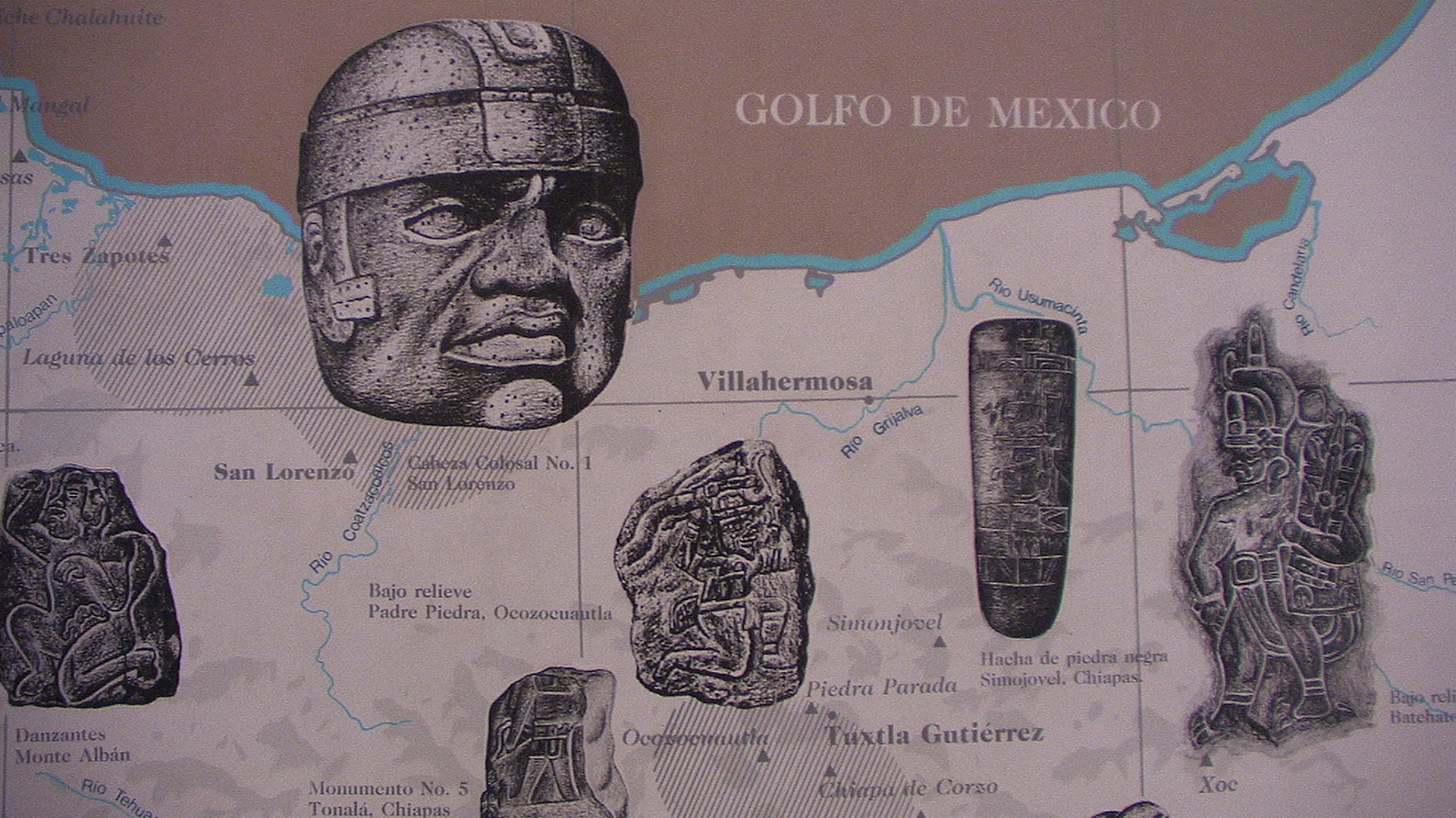
Als Olmeken (von Nahuatl Singular Ōlmēcatl beziehungsweise Plural Ōlmēcah für „Leute aus dem Kautschukland“) wurden von Archäologen die Träger der mittelamerikanischen La-Venta-Kultur bezeichnet. Ihre tatsächliche ethnische Zugehörigkeit ist unbekannt. Die Kultur der Olmeken ist von etwa 1500 bis um 400 v. Chr. entlang der Küste des Golfs von Mexiko nachweisbar. Ihre bekanntesten kulturellen Hinterlassenschaften sind mehrere Kolossalköpfe. Ob die Kultur der Olmeken als Proto-Maya-Kultur angesehen werden kann, wurde vielfach diskutiert, ist aber wegen des großen zeitlichen und räumlichen Abstands eher unwahrscheinlich.
奥尔梅克文明(Olmec)是已知的最古老的美洲文明之一。它存在和繁盛于公元前1200年到公元前400年的中美洲(现在的墨西哥中南部)。
“奥尔梅克”一词源自纳瓦特尔语中用以指奥尔梅克人的单词Ōlmēcatl(发音:/oːlˈmeːkat͡ɬ/,此词在纳瓦特尔语中之众数形为Ōlmēcah,发音/oːlˈmeːkaʔ/),而在纳瓦特尔语中,此词为ōlli(意即“橡胶”,发音/ˈoːlːi/)和mēcatl(意即“人”,发音/ˈmeːkat͡ɬ/)的合成词,故Ōlmēcatl在纳瓦特尔语中的意思可解作“胶人”。
オルメカ(Olmeca)は、紀元前1200年頃から紀元前後にかけ、先古典期のメソアメリカで栄えた文化・文明である[1]。アメリカ大陸で最も初期に生まれた文明であり、その後のメソアメリカ文明の母体となったことから、「母なる文明」と呼ばれる[2]。
オルメカとは、ナワトル語で「ゴムの国の人」を意味し、スペイン植民地時代にメキシコ湾岸の住民を指した言葉である。巨石や宝石を加工する技術を持ち、ジャガー信仰などの宗教性も有していた。その美術様式や宗教体系は、マヤ文明などの古典期メソアメリカ文明と共通するものがある。
オルメカの影響は中央アメリカの中部から南部に広がっていたが、支配下にあったのは中心地であるメキシコ湾岸地域に限られた[4]。その領域はベラクルス州南部からタバスコ州北部にかけての低地で、雨の多い熱帯気候のため、たびたび洪水が起こった。しかし、河川によって肥沃な土地が形成され、神殿を中心とした都市が築かれた[2]。
オルメカの文化は、出土するさまざまな石像に現れている。人間とジャガーを融合させた神像は、彼らにジャガーを信仰する風習があったことを物語っている[2]。祭祀場では儀式としての球技が行われ、その際には人間が生贄として捧げられた[4]。また、絵文字や数字を用い、ゼロの概念を持つなど、数学や暦が発達していた[2]。
The Olmecs (/ˈɒlmɛks, ˈoʊl-/) were the earliest known major civilization in Mesoamerica following a progressive development in Soconusco. They lived in the tropical lowlands of south-central Mexico, in the present-day states of Veracruz and Tabasco. It has been speculated that the Olmecs derive in part from neighboring Mokaya or Mixe–Zoque.
The Olmecs flourished during Mesoamerica's formative period, dating roughly from as early as 1500 BCE to about 400 BCE. Pre-Olmec cultures had flourished in the area since about 2500 BCE, but by 1600–1500 BCE, early Olmec culture had emerged, centered on the San Lorenzo Tenochtitlán site near the coast in southeast Veracruz.[1] They were the first Mesoamerican civilization, and laid many of the foundations for the civilizations that followed.[2] Among other "firsts", the Olmec appeared to practice ritual bloodletting and played the Mesoamerican ballgame, hallmarks of nearly all subsequent Mesoamerican societies. The aspect of the Olmecs most familiar now is their artwork, particularly the aptly named "colossal heads".[3] The Olmec civilization was first defined through artifacts which collectors purchased on the pre-Columbian art market in the late 19th century and early 20th century. Olmec artworks are considered among ancient America's most striking.[4]
Les Olmèques sont un ancien peuple précolombien de Mésoamérique s'étant épanoui de 1200 av. J.-C. jusqu'à 500 av. J.-C. sur la côte du golfe du Mexique, dans le bassin de Mexico, et le long de la côte Pacifique (États du Guerrero, Oaxaca et Chiapas). Issu du terme nahuatl olmeca, qui signifie « les gens du pays du caoutchouc », ce mot est lié à la découverte de la première tête colossale olmèque, en 1862. Le terme « olmèque » a été officialisé en 1942 par les olmécologues.
Gli Olmechi erano un'antica civiltà precolombiana che viveva nell'area tropicale dell'odierno Messico centro-meridionale, approssimativamente negli stati messicani di Veracruz e Tabasco sull'Istmo di Tehuantepec. La civiltà olmeca fiorì durante il periodo formativo (pre-classico) mesoamericano (vedi Cronologie mesoamericane), estendentesi approssimativamente dal 1400 a.C. al 400 a.C. Gli Olmechi costituirono la prima civiltà mesoamericana e stabilirono le fondamenta delle culture successive. Esistono prove che gli Olmechi praticassero il sacrificio umano e praticassero un primitivo gioco con la palla (Giochi con la palla mesoamericani), caratteristiche di tutte le successive culture. L'influenza culturale olmeca fu molto ampia, tanto che opere d'arte di questa civiltà sono state trovate anche a El Salvador. Questo popolo ebbe il predominio nella sua area da circa il 1200 a circa il 400 a.C. e da molti è considerata la cultura madre di tutte le successive civiltà mesoamericane.
Il cuore del territorio olmeco (la cosiddetta area nucleare olmeca) è caratterizzato da pianure alluvionali, costellate da creste di basse colline e da vulcani. Le Montagne Tuxtlas vanno a nord, lungo la baia di Campeche. E fu proprio qui che gli olmechi costruirono complessi templari, fra cui San Lorenzo Tenochtitlán, La Venta, Tres Zapotes, Laguna de los Cerros e La Mojarra. La loro influenza si estese dagli altopiani alla costa del Pacifico, vicino all'odierno Guatemala (come dimostrano i ritrovamenti di divinità olmeche).
Questa civiltà emerse e dominò tra il 1200 e il 400 a.C. e sembra che sia stata anche la prima civiltà mesoamericana a sviluppare un sistema di scrittura, anche se non ne sono ancora stati trovati esempi. Attualmente si dibatte se i simboli trovati nel 2002 e datati 650 a.C. siano o meno una forma di scrittura olmeca precedente a quella zapoteca, datata intorno al 500 a.C.[1] Ci sono anche altri geroglifici successivi, conosciuti come Epi-Olmechi, cioè post-olmechi: e se alcuni ritengono che questo epi-olmeco potrebbe essere una traslitterazione scritta che si colloca tra un precedente e sconosciuto sistema di scrittura olmeca e la scrittura dei maya, la questione resta comunque irrisolta e aperta.
Gli Olmechi sarebbero anche gli inventori del gioco della palla, che si diffuse anche nelle altre culture della regione con scopi sia ricreativi sia cerimoniali.
Attorno all'anno 1000 a.C. gli Olmechi, primi conoscitori della pianta di cacao, chiamavano il cacao kakawa; in seguito, esso fu rinominato kakaw dai Maya. [2]
Le caratteristiche e le tematiche della loro religione si svilupparono anche in seguito nelle altre culture dell'area. Stessa cosa accadde per la struttura fortemente gerarchica e verticistica delle loro città-stato.
La cultura olmeca fue la civilización que se desarrolló durante el periodo Preclásico de Mesoamérica. Aunque se han encontrado vestigios de su presencia en amplias zonas de Mesoamérica, se considera que el área nuclear olmeca —zona metropolitana— abarca la parte sureste del estado de Veracruz y el oeste de Tabasco. En ese sentido, es necesario hacer la aclaración de que el etnónimo olmeca les fue impuesto por los arqueólogos del siglo XX, y no debe ser confundido con el de los olmeca-xicalancas, que fueron un grupo que floreció en el epiclásico en sitios del centro de México, como Cacaxtla.
Durante mucho tiempo se consideró que la olmeca era la cultura madre de la civilización mesoamericana.1 Sin embargo, no está claro el proceso que dio origen al estilo artístico identificado con esta sociedad, ni hasta qué punto los rasgos culturales que se revelan en la evidencia arqueológica son creación de los olmecas del área nuclear. Se sabe, por ejemplo, que algunos de los atributos propiamente olmecas pudiesen haber aparecido, primero en Chiapas o en los Valles Centrales de Oaxaca. Entre otras dudas que están pendientes de respuesta definitiva, está la cuestión de los numerosos sitios asociados a esta cultura en la Depresión del Balsas (centro de Guerrero). Sea cual haya sido el origen de la cultura olmeca, la red de intercambios comerciales entre distintas zonas de Mesoamérica contribuyó a la difusión de muchos elementos culturales que son identificados con la cultura olmeca, incluidos el culto a las montañas y a las cuevas; el culto a la Serpiente Emplumada, como deidad asociada a la agricultura, el simbolismo religioso del jade e, incluso, el propio estilo artístico, que fue reelaborado intensamente en los siglos posteriores a la declinación de los principales centros de estos tiempos.
Ольме́ки — название племени, упоминающееся в ацтекских исторических хрониках. Название дано условно, по одному из небольших племен, живших на указанной ниже территории[1]. Создатели первой «крупной» цивилизации в Мексике, которая была наследницей культур, последовательно развивавшихся в Соконуско (на юго-западе мексиканского штата Чьяпас)[2]. Ольмеки обитали в тропических долинах южной и центральной Мексики на территории современных штатов Веракрус и Табаско. Возможно, родственны создателям культуры Мокая из Соконуско и носителям языков михе-соке.
Цивилизация ольмеков процветала в течение периода становления Мезоамерики примерно с 1500 до н. э. до 400 до н. э. Доольмекская культура существовала примерно с 2500 до н. э. по 1600-1500 до н. э. Ранние формы культуры ольмеков появились в районе Сан-Лоренсо-Теночтитлана неподалёку от побережья океана в юго-восточной части современного мексиканского штата Веракрус[3]. Во многих отношениях эта мезоамериканская цивилизация стала пионерской, повлияв на все последующие[4]. Например, ольмеки первыми ввели практику ритуального кровопролития и игру в мяч.
О цивилизации ольмеков стало известно в конце XIX — начале XX века, когда собиратели артефактов доколумбовой эпохи обнаружили на рынке казавшиеся необычными изделия. Сегодня ольмеки известны широкой публике прежде всего своими произведениями искусства, особенно гигантскими головами[5].
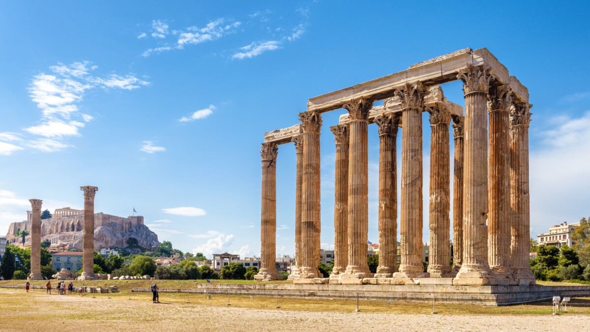
Das Olympieion (auch Tempel des Olympischen Zeus) in Athen war einer der größten Tempel im antiken Griechenland. Der Bau geht auf das 6. Jahrhundert v. Chr. zurück, wurde aber erst unter dem römischen Kaiser Hadrian im 2. Jahrhundert n. Chr. vollendet. Das Olympieion befindet sich rund 500 m östlich der Akropolis.
奥林匹亚宙斯神庙 (希腊语:Ναὸς τοῦ Ὀλυμπίου Διός, Naos tou Olympiou Dios), 又称Olympieion,是一座已毁的供奉宙斯的神庙,位于希腊首都雅典市中心,宪法广场以南700米,雅典卫城东南方500米。它始建于公元前6世纪,计划建成古代世界最伟大的寺庙,直到638年后,公元2世纪罗马帝国皇帝哈德良在位期间才得以完成。在罗马帝国时期,它是希腊最大的神庙,拥有古代世界最大的神像之一。
公元3世纪遭蛮族洗劫后,该庙被废弃。在罗马帝国灭亡后的数个世纪中,该庙的石料被大量取走,用于其他建筑的材料。今天仍可见到其遗迹,是雅典一个主要的旅游景点。
2007年1月21日,一群希腊多神教教徒在神庙举行崇拜宙斯的仪式。
The Temple of Olympian Zeus (Greek: Ναός του Ολυμπίου Διός, Naós tou Olympíou Diós), also known as the Olympieion or Columns of the Olympian Zeus, is a former colossal temple at the centre of the Greek capital Athens. It was dedicated to "Olympian" Zeus, a name originating from his position as head of the Olympian gods. Construction began in the 6th century BC during the rule of the Athenian tyrants, who envisaged building the greatest temple in the ancient world, but it was not completed until the reign of the Roman Emperor Hadrian in the 2nd century AD, some 638 years after the project had begun. During the Roman period the temple -that included 104 colossal columns- was renowned as the largest temple in Greece and housed one of the largest cult statues in the ancient world.
The temple's glory was short-lived, as it fell into disuse after being pillaged during a barbarian invasion in the 3rd century AD, just about a century after its completion. It was probably never repaired and was reduced to ruins thereafter. In the centuries after the fall of the Roman Empire, it was extensively quarried for building materials to supply building projects elsewhere in the city. Despite this, a substantial part of the temple remains today, notably sixteen of the original gigantic columns, and it continues to be part of a very important archaeological site of Greece.
L’Olympiéion (grec ancien : Ὀλυμπιεῖον), ou temple de Zeus olympien (grec ancien : Ναὸς τοῦ Ὀλυμπίου Διός), est situé au pied de l’Acropole d'Athènes. C’est un temple très vaste, d’ordre corinthien, dont il reste aujourd’hui 15 colonnes. Sa construction débuta au VIe siècle av. J.-C., et fut achevée par Hadrien en 131.
Il tempio di Zeus Olimpio (greco: Ναός του Ολυμπίου Διός) è un tempio situato ad Atene, in Grecia. Il tempio è situato a circa 500 metri dall'Acropoli e a circa 700 metri a sud del cuore di Atene, piazza Syntagma. Durante il periodo ellenistico ed il periodo romano è stato il tempio più grande della Grecia.
El templo de Zeus Olímpico, también conocido como el Olimpeion (griego Ναός του Ολυμπίου Διός, o Naos tou Olimpiou Dios), es un templo de Atenas. Aunque comenzado en el siglo VI a. C., no fue terminado hasta el reinado del emperador Adriano, en el siglo II. En las épocas helenística y romana era el templo más grande de Grecia.
ゼウス神殿またはオリュンピア=ゼウス神殿(ギリシア語: Ναὸς τοῦ Ὀλυμπίου Διός,ラテン語: Templum Iovis Olympii)は、ギリシャ、アテネのアクロポリスの東側にある神殿で、オリュンポス十二神の中の最高神であるゼウスに捧げられた神殿である。紀元前6世紀、僭主政のアテナイの時代に建設が始まったが、古代の世界で最大級であった神殿は完成させることがでなかった。神殿の完成は2世紀にローマ皇帝ハドリアヌスにより成し遂げられた。ローマ帝国期を通じて建てられた神殿の中で、この神殿は最大のものであった。
オリュンピア=ゼウス神殿またはオリュンピアのゼウス神殿の名前は、ハドリアヌスがつくらせた、金と象牙のゼウス像がオリュンピアのゼウス神殿にあったもののコピーであったことに由来する[1]。日本語でオリンピア=ゼウス神殿と表記されることもある。
L’Olympiéion (grec ancien : Ὀλυμπιεῖον), ou temple de Zeus olympien (grec ancien : Ναὸς τοῦ Ὀλυμπίου Διός), est situé au pied de l’Acropole d'Athènes. C’est un temple très vaste, d’ordre corinthien, dont il reste aujourd’hui 15 colonnes. Sa construction débuta au VIe siècle av. J.-C., et fut achevée par Hadrien en 131.
Le temple est situé au sud de l'Acropole, à environ 700 mètres du centre d'Athènes. Les fondations du premier temple remontent à -515, à l'époque de Pisistrate, mais le chantier s'est interrompu lorsque Hippias, fils de Pisistrate, fut ostracisé, en -510.
Durant la démocratie athénienne, le temple est resté inachevé, apparemment parce qu'il n'était pas dans l'esprit du temps de construire des bâtiments d'une telle ampleur. Dans sa Politique, Aristote le donne comme l'exemple de ce que les régimes tyranniques imposent inutilement à leurs populations. Les travaux ne reprennent qu'au IIIe siècle av. J.-C. avec la souveraineté macédonienne, et continuent sous le roi Antiochus IV Épiphane, qui charge l'architecte romain Decimus Cossutius de concevoir le plus grand temple du monde. Lorsque Antiochus meurt en -164, la construction du temple est à nouveau arrêtée.
En -86, Sylla, imposant à la Grèce la domination romaine, fit transporter au Capitole deux chapiteaux inachevés de l'Olympiéion, qui eurent une influence déterminante sur l'architecture romaine par l'adoption définitive de l'ordre corinthien dans toutes ses réalisations à venir.
Le temple ne fut achevé qu'en 129 (ou 131) apr. J.-C., sous l'impulsion de l'empereur Hadrien, grand admirateur de la culture grecque.
Il tempio di Zeus Olimpio (greco: Ναός του Ολυμπίου Διός) è un tempio situato ad Atene, in Grecia. Il tempio è situato a circa 500 metri dall'Acropoli e a circa 700 metri a sud del cuore di Atene, piazza Syntagma. Durante il periodo ellenistico ed il periodo romano è stato il tempio più grande della Grecia. Il tempio era costruito in marmo pentelico e misurava 108 metri in lunghezza e 41 in larghezza. Consisteva in 104 colonne corinzie, ognuna alta 17 metri. Solo 15 di queste colonne rimangono tuttora in piedi. La sedicesima colonna venne colpita da un fulmine durante un temporale nel 1852 e cadde sull'antica pavimentazione del tempio, dove è stata lasciata. Dell'imponente tempio rimangono, oltre alle colonne, il crepidoma e alcune porzioni dell'architrave tripartito.
El templo de Zeus Olímpico, también conocido como el Olimpeion (griego Ναός του Ολυμπίου Διός, o Naos tou Olimpiou Dios), es un templo de Atenas. Aunque comenzado en el siglo VI a. C., no fue terminado hasta el reinado del emperador Adriano, en el siglo II. En las épocas helenística y romana era el templo más grande de Grecia.
El templo se ubica a unos 500 metros al sureste de la Acrópolis de Atenas y a unos 700 m al sur de la Plaza Sintagma (centro de Atenas).
Sus cimientos fueron colocados en el sitio de un primer templo por el tirano Pisístrato en 515 a. C., pero el trabajo fue abandonado cuando su hijo, Hipias, fue derrocado en 510 a. C.1 Durante los años de la democracia ateniense, el templo fue dejado incompleto, porque se pensó que atentaba contra la hybris construir a tal escala. Aristóteles, en la Política, citó el templo como un ejemplo de cómo las tiranías atraían al pueblo a grandes obras de estado y lo dejaban sin tiempo, energía o medios para rebelarse.2
El trabajo fue reanudado en 174 a. C., durante la dominación macedonia de Grecia, bajo el patrocinio del rey helenístico Antíoco IV Epífanes, que contrató al arquitecto romano Cosucio para diseñar el templo más grande del mundo conocido. Cuando Antíoco murió en 164 a. C. el trabajo estaba retrasado otra vez.1
En 86 a. C., después de que las ciudades griegas cayeran bajo dominio romano, el general Sila llevó dos columnas del templo inacabado a Roma, para adornar el templo de Júpiter Capitolino en la colina Capitolina. Estas columnas influyeron en el desarrollo del estilo corintio en Roma.
En el siglo II, el templo fue retomado por el emperador Adriano, un gran admirador de la cultura griega, quien finalmente lo llevó a su conclusión en 129 (algunas fuentes dicen que en 131).1
No se sabe cuando fue destruido el edificio pero, como muchos edificios grandes de Grecia, es probable que fuera destruido por un terremoto en la Edad Media. La mayor parte de sus ruinas se usaron como materiales de construcción.
Олимпейо́н, храм Зевса Олимпийского (греч. Ναός του Ολυμπίου Διός) — самый большой храм Греции, строившийся с VI века до н. э. до II века н. э.; располагается в Афинах в 500 метрах к юго-востоку от Акрополя и около 700 метров южнее площади Синтагма.
Согласно легенде храм был построен на месте святилища мифического Девкалиона, праотца греческого народа.
Возведение храма было начато в период тирании Писистрата, в 515 г. до н. э. Афинская демократия интересовалась храмом мало, Фемистокл использовал его части для оборонительной стены, связавшей Афины с Пиреем (её раскопанный участок виден рядом с храмом).
В 175—164 гг. до н. э. строительство храма Зевса (уже в коринфском ордере) продолжил царь эллинистической Сирии Антиох IV Эпифан. В 84 году до н. э. римский диктатор Сулла снял с колонн несколько резных капителей и употребил их для строительства храма его римского аналога, Юпитера Капитолийского. Несмотря на это Тит Ливий почти столетие спустя называет афинский храм Зевса «единственным на свете, достойным этого божества».
Завершён храм был только через 650 лет после начала строительства, при римском императоре Адриане, поклоннике греческой культуры. Освящение нового храма, который Адриан посвятил Зевсу Олимпийскому, было приурочено ко второму визиту императора в Афины и стало центральным пунктом программы Всегреческих празднеств 132 г.
Храм был сильно повреждён во время нашествия герулов в 267 г. и едва ли восстанавливался после этого. После того как Феодосий запретил почитание языческих богов, элементы храма были использованы при строительстве церквей и домов.
В настоящее время от храма уцелел один угол, состоящий из 14 колонн, увенчанных коринфскими капителями, 2 отдельностоящие колонны и одна поваленная.
 Lazio
Lazio
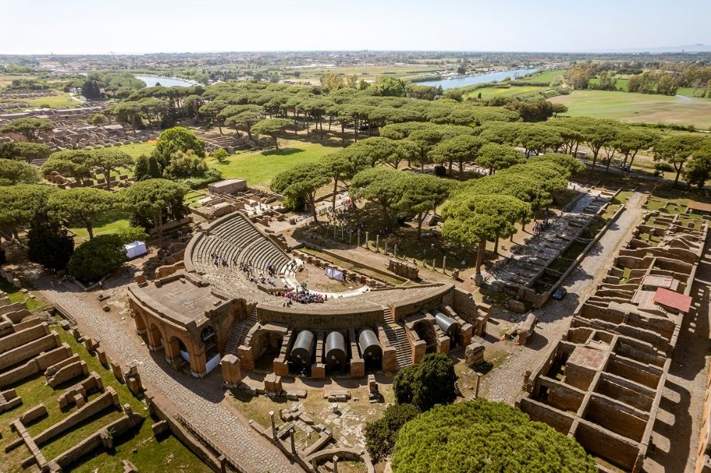
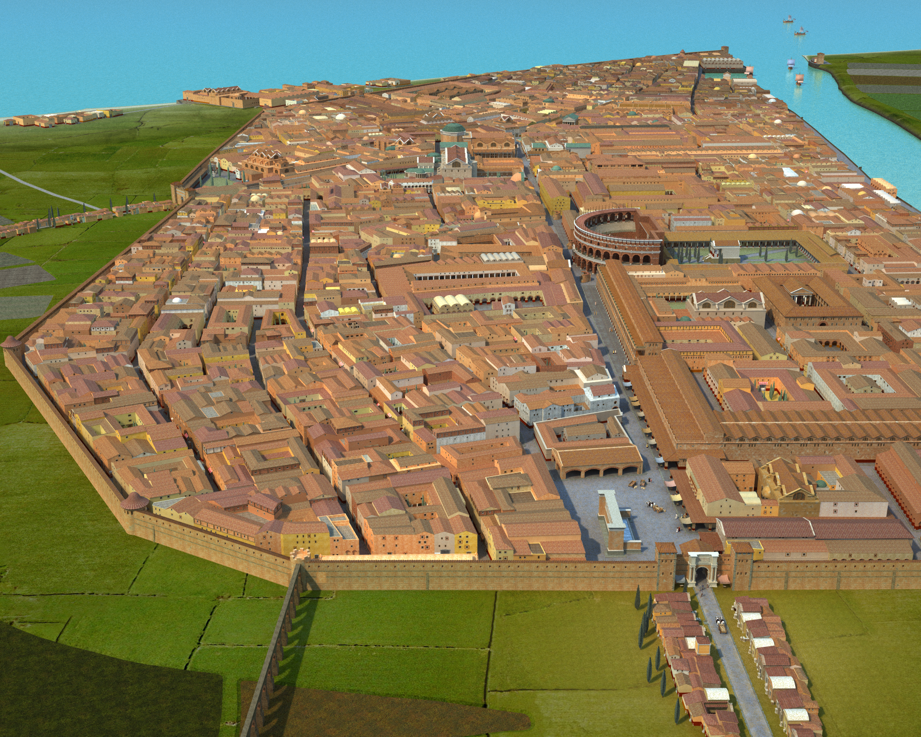
Ostia Antica ist das Ausgrabungsgelände der antiken Stadt Ostia, der ursprünglichen Hafenstadt des antiken Rom und möglicherweise dessen erster Kolonie.
Der Name Ostia leitet sich von lateinisch ostium „Eingang; Mündung“ ab, womit die Tibermündung gemeint ist. Der Name Ostia Antica (Altes Ostia) wird zur Unterscheidung vom in den 1920er Jahren neugegründeten Stadtteil Ostia verwendet. Der nordöstlich anschließende moderne Stadtteil wird nach den Ausgrabungen ebenfalls Ostia Antica genannt.
奥斯提亚安提卡(意大利语:Ostia Antica)即古奥斯提亚。是位于意大利中部拉齐奥大区罗马市奥斯提亚的一座古罗马时期的港湾都市遗迹。由于砂石堆积,现在奥斯提亚安提卡距离海岸线已有3公里。在神话记载中,这里在公元前7世纪时就已经有城市[1]。但按照实际考古记录,这座城市的历史可以追溯至公元前4世纪初期。在公元前3世纪至2世纪时,这里曾是罗马海军的主要据点。2世纪时,城市发展达到鼎盛时期。

《奥德赛》(古希腊语:Ὀδύσσεια,转写:Odýsseia,英语:Odyssey)又译《奥狄赛》、《奥德修记》、或《奥德赛飘流记》是古希腊最重要的两部史诗之一(另一部是《伊利亚特》)。《奥德赛》延续了《伊利亚特》的故事情节,是盲诗人荷马所作。这部史诗是西方文学的奠基之作,是除《伊利亚特》外现存最古老的西方文学作品。一般认为,《奥德赛》创作于公元前8世纪末的爱奥尼亚,即今希腊安纳托利亚的沿海地区。
《奥德赛》主要讲述了希腊英雄奥德修斯(或译奥德赛斯,罗马神话中称为“尤利西斯”)在特洛伊陷落后返乡的故事。十年特洛依战争结束后,奥德修斯又漂泊了十年,才回到了故乡伊萨卡。人们认为他已经死去,而他的妻子珀涅罗珀和儿子忒勒玛科斯必须面对一群放肆的求婚者,这些人相互竞争,以求与珀涅罗珀成婚。
如今,《奥德赛》已被译为多国语言,是公认的世界文学经典。许多学者认为,这部史诗是由一些诗人、歌手或专业表演者口头创作而成的。至于当时口头表演的细节是什么样,这个故事是如何由口头诗歌变为书面著作,学者至今仍争论不休。《奥德赛》的用语是一种书面的诗话希腊语,混合了伊欧里斯语、爱奥尼亚语等多种希腊方言。全诗共有12110行,通篇使用六音步长短短格。不仅是战士们的行动,诗歌的非线性的叙事方法,以及妇人和农奴们对事件发展的影响,都是《奥德赛》里引人注目的元素。在英文及其他很多语言中,单词“奥德赛”(odyssey)现在用来指代一段史诗般的征程。
《奥德赛》的结尾已经丢失。但是还有一个失落的续集,忒勒戈诺斯史诗,据说是为斯巴达的修涅诵所著,而不是荷马。一种说法是被缪西斯或昔兰尼的犹哥蒙所藏。
『オデュッセイア』(古代ギリシア語イオニア方言:ΟΔΥΣΣΕΙΑ, Ὀδύσσεια, Odysseia, ラテン語:Odyssea)は、『イーリアス』とともに「詩人ホメーロスの作」として伝承された古代ギリシアの長編叙事詩[1]。
『イーリアス』の続編作品にあたり、そのため叙事詩環の一つに数えられることもある。長編叙事詩では、古代ギリシア文学最古期にあたる。
イタケーの王である英雄オデュッセウスがトロイア戦争の勝利の後に凱旋する途中に起きた、10年間にもおよぶ漂泊が語られ[1][2]、オデュッセウスの息子テーレマコスが父を探す探索の旅も展開される。不在中に妃のペーネロペー(ペネロペ)に求婚した男たちに対する報復なども語られる[1]。
紀元前8世紀頃に吟遊詩人が吟唱する作品として成立し、その作者はホメーロスと伝承されるが、紀元前6世紀頃から文字に書かれるようになり、現在の24巻からなる叙事詩に編集された。この文字化の事業は、伝承ではアテーナイのペリクレスに帰せられる。
古代ギリシアにおいては、ギリシア神話と同様に『オデュッセイア』と『イーリアス』は、教養ある市民が必ず知っているべき知識のひとつとされた。なお『イーリアス』と『オデュッセイア』が同一の作者によるものか否かは長年の議論があるところであり、一部の研究者によって、後者は前者よりも遅く成立し、かつそれぞれの編纂者が異なるとの想定がなされている(詳細はホメーロス問題を参照)。
The Odyssey (/ˈɒdəsi/;[1] Greek: Ὀδύσσεια Odýsseia, pronounced [o.dýs.sej.ja] in Classical Attic) is one of two major ancient Greek epic poems attributed to Homer. It is, in part, a sequel to the Iliad, the other Homeric epic. The Odyssey is fundamental to the modern Western canon; it is the second-oldest extant work of Western literature, while the Iliad is the oldest. Scholars believe the Odyssey was composed near the end of the 8th century BC, somewhere in Ionia, the Greek coastal region of Anatolia.[2]
The poem mainly focuses on the Greek hero Odysseus (known as Ulysses in Roman myths), king of Ithaca, and his journey home after the fall of Troy. It takes Odysseus ten years to reach Ithaca after the ten-year Trojan War.[3] In his absence, it is assumed Odysseus has died, and his wife Penelope and son Telemachus must deal with a group of unruly suitors, the Mnesteres (Greek: Μνηστῆρες) or Proci, who compete for Penelope's hand in marriage.
The Odyssey continues to be read in the Homeric Greek and translated into modern languages around the world. Many scholars believe the original poem was composed in an oral tradition by an aoidos (epic poet/singer), perhaps a rhapsode (professional performer), and was more likely intended to be heard than read.[2] The details of the ancient oral performance and the story's conversion to a written work inspire continual debate among scholars. The Odyssey was written in a poetic dialect of Greek—a literary amalgam of Aeolic Greek, Ionic Greek, and other Ancient Greek dialects—and comprises 12,110 lines of dactylic hexameter.[4][5] Among the most noteworthy elements of the text are its non-linear plot, and the influence on events of choices made by women and slaves, besides the actions of fighting men. In the English language as well as many others, the word odyssey has come to refer to an epic voyage.
The Odyssey has a lost sequel, the Telegony, which was not written by Homer. It was usually attributed in antiquity to Cinaethon of Sparta. In one source,[which?] the Telegony was said to have been stolen from Musaeus of Athens by either Eugamon or Eugammon of Cyrene (see Cyclic poets).
L’Odyssée (en grec ancien Ὀδύσσεια / Odússeia) est une épopée grecque antique attribuée à l’aède Homèrenote 1, qui l'aurait composée après l’Iliade, vers la fin du VIIIe siècle av. J.-C. Elle est considérée comme l’un des plus grands chefs-d’œuvre de la littérature et, avec l’Iliade, comme l'un des deux « poèmes fondateurs » de la civilisation européenne.
L’Odyssée relate le retour chez lui du héros Ulysse, qui, après la guerre de Troie dans laquelle il a joué un rôle déterminant, met dix ans à revenir dans son île d'Ithaque, pour y retrouver son épouse Pénélope, qu'il délivre des prétendants, et son fils Télémaque. Au cours de son voyage sur mer, rendu périlleux par le courroux du dieu Poséidon, Ulysse rencontre de nombreux personnages mythologiques, comme la nymphe Calypso, la princesse Nausicaa, les Cyclopes, la magicienne Circé et les sirènes. L'épopée contient aussi un certain nombre d'épisodes qui complètent le récit de la guerre de Troie, par exemple la construction du cheval de Troie et la chute de la ville, qui ne sont pas évoquées dans l’Iliade. L’Odyssée compte douze mille cent neuf hexamètres dactyliques, répartis en vingt-quatre chants, et peut être divisée en trois grandes parties : la Télémachie (chants I-IV), les Récits d'Ulysse (chants V-XII) et la Vengeance d'Ulysse (chants XIII-XXIV)2,1.
L’Odyssée a inspiré un grand nombre d'œuvres littéraires et artistiques au cours des siècles, et le terme « odyssée » est devenu par antonomase un nom commun désignant un « récit de voyage plus ou moins mouvementé et rempli d'aventures singulières »3.
L'Odissea (in greco antico: Ὀδύσσεια, Odýsseia) è uno dei due grandi poemi epici greci attribuiti all'opera del poeta Omero. Narra delle vicende riguardanti l'eroe Odisseo (o Ulisse, con il nome latino), dopo la fine della Guerra di Troia, narrata nell'Iliade. Assieme a quest'ultima, rappresenta uno dei testi fondamentali della cultura classica occidentale e viene tuttora comunemente letto in tutto il mondo sia nella versione originale che nelle sue numerose traduzioni.
La Odisea (en griego: Ὀδύσσεια, Odýsseia) es un poema épico griego compuesto por 24 cantos, atribuido al poeta griego Homero. Se cree que fue compuesta en el siglo VIII a. C. en los asentamientos que tenía Grecia en la costa oeste del Asia Menor (actual Turquía asiática). Según otros autores, la Odisea se completa en el siglo VII a. C. a partir de poemas que sólo describían partes de la obra actual. Fue originalmente escrita en lo que se ha llamado dialecto homérico. Narra la vuelta a casa, tras la Guerra de Troya, del héroe griego Odiseo (al modo latino, Ulises: Ὀδυσσεὺς en griego; Vlixes en latín). Además de haber estado diez años fuera luchando, Odiseo tarda otros diez años en regresar a la isla de Ítaca, donde poseía el título de rey, período durante el cual su hijo Telémaco y su esposa Penélope han de tolerar en su palacio a los pretendientes que buscan desposarla (pues ya creían muerto a Odiseo), al mismo tiempo que consumen los bienes de la familia.
La mejor arma de Odiseo es su mētis o astucia. Gracias a su inteligencia —además de la ayuda provista por Palas Atenea, hija de Zeus Cronida— es capaz de escapar de los continuos problemas a los que ha de enfrentarse por designio de los dioses. Para esto, planea diversas artimañas, bien sean físicas —como pueden ser disfraces— o con audaces y engañosos discursos de los que se vale para conseguir sus objetivos.
El poema es, junto a la Ilíada, uno de los primeros textos de la épica grecolatina y por tanto de la literatura occidental. Se cree que el poema original fue transmitido por vía oral durante siglos por aedos que recitaban el poema de memoria, alterándolo consciente o inconscientemente. Era transmitido en dialectos de la Antigua Grecia. Ya en el siglo IX a. C., con la reciente aparición del alfabeto, tanto la Odisea como la Ilíada pudieron ser las primeras obras en ser transcritas, aunque la mayoría de la crítica se inclina por datarlas en el siglo VIII a. C. El texto homérico más antiguo que conocemos es la versión de Aristarco de Samotracia (siglo II a. C.). El poema está escrito usando una métrica llamada hexámetro dactílico. Cada línea de la Odisea original estaba formada por seis unidades o pies, siendo cada pie dáctilo o espondeo.1 Los primeros cinco pies eran dáctilos y el último podía ser un espondeo o bien un troqueo. Los distintos pies se separan por cesuras o pausas.
«Одиссе́я» (др.-греч. Ὀδύσσεια) — вторая после «Илиады» классическая поэма, приписываемая древнегреческому поэту Гомеру. Создана, вероятно, в VIII веке до н. э. или несколько позже. Рассказывает о приключениях мифического героя по имени Одиссей во время его возвращения на родину по окончании Троянской войны, а также о приключениях его жены Пенелопы, ожидавшей Одиссея на Итаке.
Как и другое знаменитое произведение Гомера, «Илиада», «Одиссея» изобилует мифическими элементами, которых здесь даже больше (встречи с циклопом Полифемом, волшебницей Киркой, богом Эолом и т. п.). Большинство приключений в поэме описывает сам Одиссей во время пира у царя Алкиноя.
 History
J 0 - 500 AD
History
I 500 - 0 BC
History
H 1000 - 500 BC
History
G 1500 - 1000 BC
History
E 2500 - 2000 BC
History
F 2000 - 1500 BC
Syria
History
J 0 - 500 AD
History
I 500 - 0 BC
History
H 1000 - 500 BC
History
G 1500 - 1000 BC
History
E 2500 - 2000 BC
History
F 2000 - 1500 BC
Syria
 World Heritage
Civilization
World Heritage
Civilization

Palmyra (arabisch تدمر Tadmur; aramäisch ܬܕܡܘܪܬܐ Tedmurtā; hebräisch תדמור Tadmor), gegenwärtig auch Tadmor genannt, ist eine antike Oasenstadt im heutigen Gouvernement Homs in Syrien. Sie liegt auf dem Gebiet der modernen Stadt Tadmor, die vor dem Bürgerkrieg etwa 51.000 Einwohner hatte.
Die ersten archäologischen Funde stammten aus der Jungsteinzeit. Die erste schriftliche Erwähnung der Stadt selbst erfolgte in altorientalischer Zeit: Sie wurde in den Annalen mehrerer assyrischer Könige und im Alten Testament erwähnt. Palmyra war später Teil des Seleukidenreiches und erlebte seine Blütezeit nach der Annexion durch das Römische Reich im 1. Jahrhundert n. Chr.
Palmyra verfügte über eine gewisse Autonomie innerhalb des Römischen Reiches und wurde Teil der Provinz Syria. Die Metropole besaß einen eigenen Senat, der für öffentliche Arbeiten und die lokale Miliz zuständig war, und ein unabhängiges Steuersystem. Im 3. Jahrhundert wurde sie zur colonia erhoben. In der Zeit der Reichskrise des 3. Jahrhunderts gewann die Stadt stark an politischer Bedeutung und wurde 270 kurzzeitig unabhängig. Das Reich der Stadt stellte einen bedeutenden Machtfaktor im Vorderen Orient dar. Palmyra wurde jedoch 272 von römischen Truppen wieder erobert und die Stadt 273 nach einer gescheiterten zweiten Rebellion weitgehend zerstört.
Palmyra lag an einer wichtigen Karawanenstraße in Syrien, auf halber Strecke von Damaskus über die römische Oase Al-Dumair und weiter über das Kastell Resafa bis zum Euphrat. Inmitten der syrischen Wüste spenden zwei Quellen Wasser, mit dem die noch immer erhaltenen Palmengärten im Süden und Osten der Stadt bewässert werden. Der Reichtum der Stadt ermöglichte die Errichtung von monumentalen Bauprojekten. Im dritten Jahrhundert war die Stadt eine wohlhabende Metropole und zu einem regionalen Zentrum des Nahen Ostens aufgestiegen. Die Palmyrer gehörten zu den renommierten Händlern, etablierten Stationen entlang der Seidenstraße und betrieben im gesamten Reich Handel. Die Sozialstruktur der Stadt war tribal und ihre Bewohner sprachen mit dem Palmyrenischen Dialekt des Aramäischen eine eigene Sprache. Griechisch wurde für kommerzielle und diplomatische Zwecke verwendet. Die Kultur von Palmyra, die durch die Römer, Griechen und Perser beeinflusst wurde, ist in der Region einzigartig. Die Einwohner verehrten lokale Gottheiten und mesopotamische und arabische Götter.
Die Stadt gehört seit der Vertreibung der Osmanen 1918 zu Syrien als eigenständigem Staat. Sie beherbergt heute unverwechselbare Kunst und Architektur und wurde 1980 zum UNESCO-Weltkulturerbe erklärt.Palmyra (/ˌpɑːlˈmaɪrə/; Palmyrene: ![]() Tadmor; Arabic: تَدْمُر Tadmur) is an ancient Semitic city in present-day Homs Governorate, Syria. Archaeological finds date back to the Neolithic period, and documents first mention the city in the early second millennium BC. Palmyra changed hands on a number of occasions between different empires before becoming a subject of the Roman Empire in the first century AD.
Tadmor; Arabic: تَدْمُر Tadmur) is an ancient Semitic city in present-day Homs Governorate, Syria. Archaeological finds date back to the Neolithic period, and documents first mention the city in the early second millennium BC. Palmyra changed hands on a number of occasions between different empires before becoming a subject of the Roman Empire in the first century AD.
The city grew wealthy from trade caravans; the Palmyrenes became renowned as merchants who established colonies along the Silk Road and operated throughout the Roman Empire. Palmyra's wealth enabled the construction of monumental projects, such as the Great Colonnade, the Temple of Bel, and the distinctive tower tombs. Ethnically, the Palmyrenes combined elements of Amorites, Arameans, and Arabs. The city's social structure was tribal, and its inhabitants spoke Palmyrene (a dialect of Aramaic), while using Greek for commercial and diplomatic purposes. Greco-Roman culture influenced the culture of Palmyra, which produced distinctive art and architecture that combined eastern and western traditions. The city's inhabitants worshiped local Semitic deities, Mesopotamian and Arab gods.
By the third century AD Palmyra had become a prosperous regional center. It reached the apex of its power in the 260s, when the Palmyrene King Odaenathus defeated Persian Emperor Shapur I. The king was succeeded by regent Queen Zenobia, who rebelled against Rome and established the Palmyrene Empire. In 273, Roman emperor Aurelian destroyed the city, which was later restored by Diocletian at a reduced size. The Palmyrenes converted to Christianity during the fourth century and to Islam in the centuries following the conquest by the 7th-century Rashidun Caliphate, after which the Palmyrene and Greek languages were replaced by Arabic.
Before AD 273, Palmyra enjoyed autonomy and was attached to the Roman province of Syria, having its political organization influenced by the Greek city-state model during the first two centuries AD. The city became a Roman colonia during the third century, leading to the incorporation of Roman governing institutions, before becoming a monarchy in 260. Following its destruction in 273, Palmyra became a minor center under the Byzantines and later empires. Its destruction by the Timurids in 1400 reduced it to a small village. Under French Mandatory rule in 1932, the inhabitants were moved into the new village of Tadmur, and the ancient site became available for excavations.
Palmyre (Παλμύρα / Palmúra en grec ancien, تدمر / tadmor en arabe) est une oasis du désert de Syrie, à 210 km au nord-est de Damas, où se situe un site historique très riche en ruines archéologiques, et la ville moderne de Tadmor.
Le site est classé patrimoine mondial de l'UNESCO depuis 1980, puis classé « en péril » pendant la guerre civile syrienne.
Palmira (in palmireno ![]() ; in arabo: تدمر), chiamata anche la Sposa del Deserto, fu in tempi antichi una delle più importanti città della Siria.
; in arabo: تدمر), chiamata anche la Sposa del Deserto, fu in tempi antichi una delle più importanti città della Siria.
Palmira (en árabe تدمر Tadmor1 o Tadmir) fue una antigua ciudad situada en el desierto de Siria, en la actual provincia de Homs a 3 km de la moderna ciudad de Tedmor2 o Tadmir, (versión árabe de la misma palabra aramea "palmira", que significa "ciudad de los árboles de dátil"). En la actualidad sólo persisten sus amplias ruinas que son foco de una abundante actividad turística internacional. La antigua Palmira fue la capital del Imperio de Palmira bajo el efímero reinado de la reina Zenobia, entre los años 268 - 272.
Palmira fue elegida como Patrimonio de la Humanidad en 1980. El 20 de junio de 2013, la Unesco incluyó a todos los sitios sirios en la lista del Patrimonio de la Humanidad en peligro para alertar sobre los riesgos a los que están expuestos debido a la Guerra Civil Siria.3
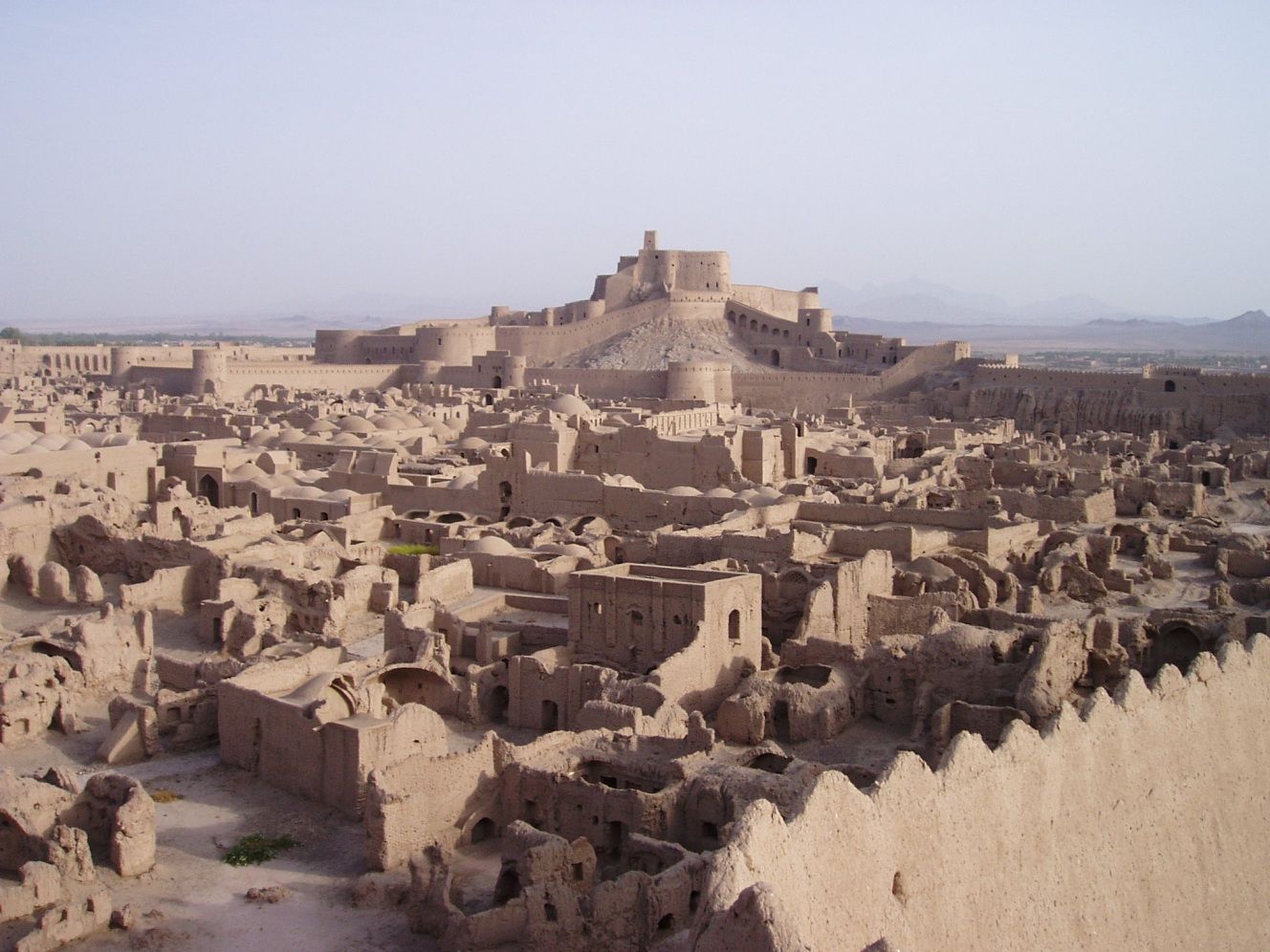
Die Zitadelle von Bam in der Wüste im Süden des iranischen Hochplateaus stammt ebenfalls aus der Periode der Achämeniden (6. bis 4. vorchristliches Jahrhundert). Ihre goldene Zeit erlebte die Stadt vom 7. bis 11. Jahrhundert als Kreuzungspunkt der Handelsrouten und als Produktionsstätte von Seiden- und Baumwolltextilien. Ihre Moschee ist eine der ältesten des Iran. Die UNESCO hat Bam zugleich in die Rote Liste des gefährdeten Welterbes aufgenommen. Die Stadt wurde am 26. Dezember 2003 von einem Erdbeben der Stärke 6,5 heimgesucht, dem über 26.000 Menschen zum Opfer fielen.