漢德百科全書 | 汉德百科全书

       
Chinese — German
Geography Strait of the world

Bashi-Straße
http://www.net4info.de/photos/cpg/albums/userpics/10001/Bashi_Channel.jpg
This image, video or audio may be copyrighted. It is used for educational purposes only. If you find it, please notify us byand we will remove it immediately.
Beringstraße
白令海峡(英语:Bering Strait;楚科奇语:Эʼрвытгыр、俄语:Бе́рингов проли́в),或译白林海峡,是太平洋的一个海峡,位于亚洲最东点的迭日涅夫角(169°43' W)和美洲最西点的威尔士王子角(168°05' W)之间的海峡,位于大约北纬65° 40',宽约35-86公里,深度在30-50米之间。这个海峡连接了楚科奇海(北冰洋的一部分)和白令海(太平洋的一部分),位于俄罗斯和阿拉斯加中间。它的名字来自丹麦探险家的维他斯·白令。白令海峡正中间有代奥米德群岛。
http://www.net4info.de/photos/cpg/albums/userpics/10002/Beringstrasse.png
白令海峡(英语:Bering Strait;楚科奇语:Эʼрвытгыр、俄语:Бе́рингов проли́в),或译白林海峡,是太平洋的一个海峡,位于亚洲最东点的迭日涅夫角(169°43' W)和美洲最西点的威尔士王子角(168°05' W)之间的海峡,位于大约北纬65° 40',宽约35-86公里,深度在30-50米之间。这个海峡连接了楚科奇海北冰洋的一部分)和白令海太平洋的一部分),位于俄罗斯和阿拉斯加中间。它的名字来自丹麦探险家的维他斯·白令。白令海峡正中间有代奥米德群岛
Die Beringstraße (englisch Bering Straitrussisch Бе́рингов проли́в/Beringow proliw) ist eine Meerenge zwischen den Kontinenten Asien und Amerika. Die Meerenge verbindet den Arktischen Ozean mit dem Pazifik. Wie das südlich davon gelegene Beringmeer wurde sie nach dem Dänen Vitus Bering benannt, der die Meerenge 1728 als Marineoffizier in russischen Diensten durchfuhr.
This image, video or audio may be copyrighted. It is used for educational purposes only. If you find it, please notify us byand we will remove it immediately.
Palkstraße
http://www.net4info.de/photos/cpg/albums/userpics/10001/Palk_Strait.jpg
This image, video or audio may be copyrighted. It is used for educational purposes only. If you find it, please notify us byand we will remove it immediately.
Nordkanal/North Channel
This image, video or audio may be copyrighted. It is used for educational purposes only. If you find it, please notify us byand we will remove it immediately.
Straße von Bonifacio/Bocche di Bonifacio
This image, video or audio may be copyrighted. It is used for educational purposes only. If you find it, please notify us byand we will remove it immediately.
Bosporus

Der Bosporus (griechisch Βόσπορος „Rinderfurt“, von βοῦς boũs „Rind, Ochse“ und πόρος póros „Weg, Furt“; türkisch Boğaz „Schlund“, bzw. Karadeniz Boğazı für „Schlund des Schwarzen Meeres“; veraltet „Straße von Konstantinopel“) ist eine Meerenge zwischen Europa und Kleinasien, die das Schwarze Meer (in der Antike: Pontos Euxeinos) mit dem Marmarameer (in der Antike: Propontis) verbindet; daher stellt er einen Abschnitt der südlichen Innereurasischen Grenze dar. Auf seinen beiden Seiten befindet sich die Stadt Istanbul, deren Geografie er maßgeblich prägt. Der Bosporus hat eine Länge von ca. 30 Kilometern und eine Breite von 700 bis 2500 Metern. In der Mitte variiert die Tiefe zwischen 36 und 124 Metern (bei Bebek). Innerhalb des Bosporus liegt auf der westlichen Seite das Goldene Horn, eine langgezogene Bucht und ein seit langem genutzter natürlicher Hafen.

Die Durchfahrtsrechte für die internationale Schifffahrt wurden 1936 im Vertrag von Montreux geregelt.


This image, video or audio may be copyrighted. It is used for educational purposes only. If you find it, please notify us byand we will remove it immediately.
Koreastraße
http://www.net4info.de/photos/cpg/albums/userpics/10002/Koreastrasse.png

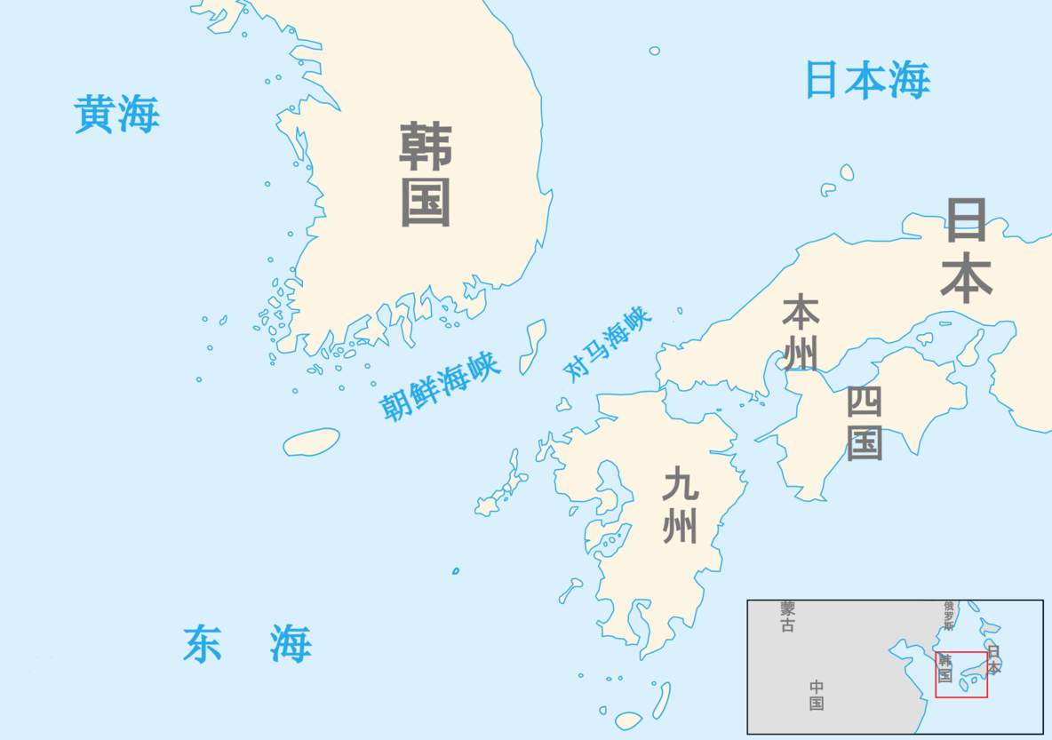
Die Koreastraße (selten auch Straße von Korea oder Tsushimastraße genannt) ist eine Meeresdurchfahrt zwischen dem Ostchinesischen Meer im Südwesten und dem Japanischen Meer im Nordosten. Im Norden ist die Koreastraße durch die Koreanische Halbinsel begrenzt, im Süden durch die japanischen Inseln Kyūshū und Honshū.

Die Durchfahrt hat eine Tiefe von etwa 90 Meter und ist von den Tsushima-Inseln geteilt.

 
This image, video or audio may be copyrighted. It is used for educational purposes only. If you find it, please notify us byand we will remove it immediately.
Tatarensund/Тата́рский проли́в/Tatarski proliw/Tataren-Straße/间宫海峡/間宮海峡
https://www.net4info.de/photos/cpg/albums/userpics/10001/Tatarensund.png
This image, video or audio may be copyrighted. It is used for educational purposes only. If you find it, please notify us byand we will remove it immediately.
Dardanellen/Dardanelles

This image, video or audio may be copyrighted. It is used for educational purposes only. If you find it, please notify us byand we will remove it immediately.
Östlicher Bosporus/Босфор Восточный/Eastern Bosphorus

This image, video or audio may be copyrighted. It is used for educational purposes only. If you find it, please notify us byand we will remove it immediately.
Tsushima-Straße/対馬海峡/Tsushima Kaikyō
对马海峡(日语:対馬海峡/つしまかいきょう Tsushima kaikyō ;朝鲜语:쓰시마해협/쓰시마海峽 Sseusima haehyeop ),西方历史作品常译作Tsu Shima Strait或Tsu-Shima Strait,是朝鲜海峡(或大韩海峡)的一部分,位于对马群岛的东南侧。西北侧衔接朝鲜半岛的则是釜山海峡。 大韩海峡位于韩国与日本之间,连接日本海。其中,较宽的对马海峡西北界于对马群岛的东南侧,东北衔接本州,南接九州及五岛列岛。最窄处位于对马岛南部下岛(下島(しもじま);Shimojima)的东南角与对马海峡中最接近本州尖端的壹岐岛之间。由于经由对马海峡的航线可穿过位于本州与九州之间狭窄的关门海峡通往日本的濑户内海南端,使得对马海峡成为世界上最繁忙的水道之一。
https://www.net4info.de/photos/cpg/albums/userpics/10001/Dui20Ma20Hai20Xia20.png
This image, video or audio may be copyrighted. It is used for educational purposes only. If you find it, please notify us byand we will remove it immediately.
Straße von Dover/Strait of Dover
This image, video or audio may be copyrighted. It is used for educational purposes only. If you find it, please notify us byand we will remove it immediately.