
Deutsch-Chinesische Enzyklopädie, 德汉百科
 *Mediterranean Sea
Egypt
*Mediterranean Sea
Egypt
 Ancient Egypt
 History
 D 3000 - 2500 BC
History
B 5000 - 4000 BC
History
E 2500 - 2000 BC
History
F 2000 - 1500 BC
History
G 1500 - 1000 BC
History
H 1000 - 500 BC
History
I 500 - 0 BC
History
J 0 - 500 AD
D 3000 - 2500 BC
History
B 5000 - 4000 BC
History
E 2500 - 2000 BC
History
F 2000 - 1500 BC
History
G 1500 - 1000 BC
History
H 1000 - 500 BC
History
I 500 - 0 BC
History
J 0 - 500 AD
 World Heritage
 Civilization
古埃及(阿拉伯语:مصر القديمة)是位于非洲东北部尼罗河中下游地区的一段时间跨度近3000年的古代文明,开始于公元前32世纪左右时美尼斯统一上下埃及建立第一王朝,终止于公元前343年波斯再次征服埃及,虽然之后古埃及文化还有少量延续,但到公元以后的时代,古埃及已经彻底被异族文明所取代,在连象形文字也被人们遗忘后,古代史前社会留给后人的是宏伟的建筑与无数谜团,1798年,拿破仑远征埃及,发现罗塞塔石碑,1822年法国学者商博良解读象形文字成功,埃及学才诞生,古埃及文明才重见天日。直到今日都还不断被挖掘出来。
古埃及的居民是由北非的土著居民和来自西亚的游牧民族塞姆人融合形成的多文化圈。约公元前6000年,因为地球轨道的运转规律性变化、间冰期的高峰过去等客观气候因素,北非茂密的草原开始退缩,人们放弃游牧而开始寻求固定的水源以耕作,即尼罗河河谷一带,公元前4千年后半期,此地逐渐形成国家,至公元前343年为止,共经历前王朝、早王朝、古王国、第一中间期、中王国、第二中间期、新王国、第三中间期、后王朝9个时期31个王朝的统治(参见“古埃及历史”一节)。其中古埃及在十八王朝时(公元前15世纪)达到鼎盛,南部尼罗河河谷地带的上埃及的领域由现在的苏丹到埃塞俄比亚,而北部三角洲地区的下埃及除了现在的埃及和部分利比亚以外,其东部边界越过西奈半岛直达迦南平原。[1]
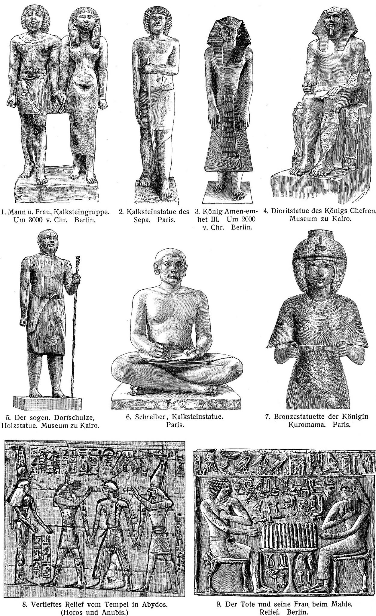
在社会制度方面,古埃及有自己的文字系统,完善的行政体系和多神信仰的宗教系统,其统治者称为法老,因此古埃及又称为法老时代或法老埃及[2]。古埃及的国土紧密分布在尼罗河周围的狭长地带,是典型的水力帝国[来源请求]。古埃及跟很多文明一样,具有保存遗体的丧葬习俗,透过这些木乃伊的研究能一窥当时人们的日常生活,对古埃及的研究在学术界已经形成一门专门的学科,称为“埃及学”。
古埃及文明的产生和发展同尼罗河密不可分,如古希腊历史学家希罗多德所言:“埃及是尼罗河的赠礼。”古埃及时,尼罗河几乎每年都泛滥,淹没农田,但同时也使被淹没的土地成为肥沃的耕地。尼罗河还为古埃及人提供交通的便利,使人们比较容易的来往于河畔的各个城市之间。古埃及文明之所以可以绵延数千年而不间断,另一个重要的原因是其相对与外部世界隔绝的地理环境,古埃及北面和东面分别是地中海和红海,而西面则是沙漠,南面是一系列大瀑布,只有东北部有一个通道通过西奈半岛通往西亚。这样的地理位置,使外族不容易进入埃及,从而保证古埃及文明的稳定延续。相比较起来,周围相对开放的同时代的两河流域文明则经常被不同民族所主宰,两者对后世所带来的价值观也完全不同。Altes Ägypten ist die allgemeine Bezeichnung für das Land Ägypten im Altertum. Der ägyptische Name lautete Kemet und bedeutet „schwarzes Land“. Kemet bezeichnet das Delta des Nils und geht auf den schwarzen Schlamm zurück, der nach der jährlichen Nilschwemme zurückblieb und eine fruchtbare Ernte garantierte. Eine andere Bezeichnung für das Land des Altertums war Ta meri (T3 mrj), was mit „geliebtes Land“ übersetzt wird.[1]
エジプトは不毛の砂漠地帯であるが、毎年春のナイル川の増水で水に覆われる地域には河土が運ばれて堆積し、農耕や灌漑が可能になる。この氾濫原だけが居住に適しており、主な活動はナイル河畔で行われた。ナイル川の恩恵を受ける地域はケメト(黒い大地)と呼ばれ、ケメトはエジプトそのものを指す言葉として周囲に広がるデシェレト(赤い大地、ナイル川の恩恵を受けない荒地)と対比される概念だった。このケメトの範囲の幅は非常に狭く、ナイル川の本流・支流から数kmの範囲にとどまっていた。しかしながら川の周囲にのみ人が集住しているということは交通においては非常に便利であり、川船を使って国内のどの地域にも素早い移動が可能であった。この利便性は、ナイル河畔に住む人々の交流を盛んにし、統一国家を建国し維持する基盤となった。
ナイル川本流からナイル川の上流は谷合でありナイル川1本だけが流れ、下流はデルタ地帯(ナイル川デルタ)が広がっている。最初に上流地域(上エジプト)と下流地域(下エジプト)[1]でそれぞれ違った文化が発展した後に統一されたため、ファラオ(王)の称号の中に「上下エジプト王」という部分が残り、古代エジプト人も自国のことを「二つの国」と呼んでいた。
毎年のナイル川の氾濫を正確に予測する必要から天文観測が行われ、太陽暦が作られた。太陽とシリウス星が同時に昇る頃、ナイル川は氾濫したという。また、氾濫が収まった後に農地を元通り配分するため、測量術、幾何学、天文学が発達した。ヒエログリフから派生したワディ・エル・ホル文字と原シナイ文字(原カナン文字)は世界の殆どのアルファベットの起源となったされる。
エジプト文明と並ぶ最初期における農耕文明の一つであるメソポタミア文明が、民族移動の交差点にあたり終始異民族の侵入を被り支配民族が代わったのと比べ、地理的に孤立した位置にあったエジプトは比較的安定しており、部族社会が城壁を廻らせて成立する都市国家の痕跡は今の所発見されていない。
Ancient Egypt was a civilization of ancient North Africa, concentrated along the lower reaches of the Nile River in the place that is now the country Egypt. Ancient Egyptian civilization followed prehistoric Egypt and coalesced around 3100 BC (according to conventional Egyptian chronology)[1] with the political unification of Upper and Lower Egypt under Menes (often identified with Narmer).[2] The history of ancient Egypt occurred as a series of stable kingdoms, separated by periods of relative instability known as Intermediate Periods: the Old Kingdom of the Early Bronze Age, the Middle Kingdom of the Middle Bronze Age and the New Kingdom of the Late Bronze Age.
Egypt reached the pinnacle of its power in the New Kingdom, ruling much of Nubia and a sizable portion of the Near East, after which it entered a period of slow decline. During the course of its history Egypt was invaded or conquered by a number of foreign powers, including the Hyksos, the Libyans, the Nubians, the Assyrians, the Achaemenid Persians, and the Macedonians under the command of Alexander the Great. The Greek Ptolemaic Kingdom, formed in the aftermath of Alexander's death, ruled Egypt until 30 BC, when, under Cleopatra, it fell to the Roman Empire and became a Roman province.[3]
The success of ancient Egyptian civilization came partly from its ability to adapt to the conditions of the Nile River valley for agriculture. The predictable flooding and controlled irrigation of the fertile valley produced surplus crops, which supported a more dense population, and social development and culture. With resources to spare, the administration sponsored mineral exploitation of the valley and surrounding desert regions, the early development of an independent writing system, the organization of collective construction and agricultural projects, trade with surrounding regions, and a military intended to assert Egyptian dominance. Motivating and organizing these activities was a bureaucracy of elite scribes, religious leaders, and administrators under the control of a pharaoh, who ensured the cooperation and unity of the Egyptian people in the context of an elaborate system of religious beliefs.[4][5]
The many achievements of the ancient Egyptians include the quarrying, surveying and construction techniques that supported the building of monumental pyramids, temples, and obelisks; a system of mathematics, a practical and effective system of medicine, irrigation systems and agricultural production techniques, the first known planked boats,[6] Egyptian faience and glass technology, new forms of literature, and the earliest known peace treaty, made with the Hittites.[7] Ancient Egypt has left a lasting legacy. Its art and architecture were widely copied, and its antiquities carried off to far corners of the world. Its monumental ruins have inspired the imaginations of travelers and writers for centuries. A new-found respect for antiquities and excavations in the early modern period by Europeans and Egyptians led to the scientific investigation of Egyptian civilization and a greater appreciation of its cultural legacy.[8]
L'Égypte antique est une ancienne civilisation du nord-est de l'Afrique, concentrée le long du cours inférieur du Nil, dans ce qui constitue aujourd'hui l'Égypte.
La civilisation de l'Égypte antique prend forme autour de -31501 avec l'unification politique de la Haute-Égypte au sud et de la Basse-Égypte au nord sous le règne du premier roi et se développe sur plus de trois millénaires2. Son histoire est parsemée d'une série de périodes stables politiquement, entrecoupées de plusieurs périodes intermédiaires, plus troublées. L'Égypte antique atteint son apogée sous le Nouvel Empire puis entre dans une période de lent déclin. Le pays subit les assauts répétés de puissances étrangères dans cette période tardive et le règne des pharaons prend officiellement fin en -30 où l'Empire romain conquiert l'Égypte pour en faire une province3.
Le succès de la civilisation égyptienne antique découle en partie de sa capacité à s'adapter aux conditions de la vallée du Nil. L'inondation prévisible du fleuve et le contrôle de l'irrigation de la vallée produit des récoltes excédentaires qui alimentent le développement social et culturel du pays. Ce surplus agricole donne à l'administration les moyens de financer l'exploitation minière de la vallée et des régions voisines du désert. Le développement rapide d'un système d'écriture indépendant, l'organisation de constructions collectives et de projets agricoles, les relations commerciales avec les pays voisins et une armée solide permettent à l'Égypte d'affirmer sa domination sur la région. Toutes ces activités sont organisées par une bureaucratie de scribes, de dirigeants religieux et d'administrateurs sous le contrôle du pharaon qui assure l'unité du peuple égyptien dans le cadre d'un système complexe de croyances religieuses4,5.
Les nombreuses réalisations des Égyptiens de l'Antiquité comprennent l'extraction minière, l'arpentage et les techniques de construction qui facilitent la construction de pyramides monumentales, de temples et d'obélisques. On compte également à leur crédit le développement des mathématiques, de la médecine, de l'irrigation et de la production agricole, la construction des premiers navires connus, la faïence égyptienne, de nouvelles formes de littérature6. Du rassemblement des tribus primitives qui créent le premier royaume pharaonique jusqu'à son absorption au Ier siècle av. J.-C., l'Égypte antique est le théâtre d'évènements majeurs qui influencent assurément la culture et l'imaginaire des peuples lui ayant succédé. Son art et son architecture sont largement copiés et ses antiquités sont disséminées aux quatre coins du monde. Un regain d'intérêt pour la période antique au début de l'époque moderne conduit à de nombreuses investigations scientifiques de la civilisation égyptienne, notamment par des fouilles, et à une meilleure appréciation de son héritage culturel, pour l'Égypte et le monde7.
Con Antico Egitto si intende la civiltà sviluppatasi lungo la Valle del Nilo a partire dalle cateratte, a sud e al confine con l’attuale Sudan[N 1], alla foce, al delta, nel Mar Mediterraneo, per un’estensione complessiva di circa 1000 km. Benché il territorio fosse molto più vasto, comprendendo gran parte anche del Deserto Libico-Nubiano, gli insediamenti umani, fin dai tempi più remoti, si svilupparono solo nella stretta fascia verdeggiante a ridosso delle rive del fiume larga, in alcuni punti anche solo poche centinaia di metri.
Fin dal 3500 a.C., di pari passo con l'avvento dell'agricoltura, in particolare la coltivazione del grano, dell’orzo e del lino, si ha contezza di insediamenti umani specie lungo le rive del Nilo[1]. Le piene annuali del fiume, infatti, favorivano la coltivazione anche con più raccolti annui grazie ai sedimenti, particolarmente fertili (Limo), che il fiume, nel suo ritirarsi, lasciava sul terreno. Ciò comportò, fin dai tempi più remoti, conseguentemente, la necessità di controllare, incanalare e conservare le acque onde garantire il costante approvvigionamento, vuoi per il sostentamento umano, vuoi per quello del bestiame e delle piantagioni.
Non è da escludersi che proprio la complessa necessità di dover far fronte alle esigenze connesse con la gestione dell’agricoltura, e segnatamente, delle acque nilotiche, abbia favorito proprio il formarsi delle prime comunità su territori parziali tuttavia ben differenziati e politicamente e geograficamente individuabili. Tali entità, normalmente individuate con il termine greco di nomoi, ben presto si costituirono in due distinte entità geo-politiche più complesse. Tale l’importanza del fiume Nilo, che attraversava tutto il paese, che anche le denominazioni di tali due macro-aree fanno riferimento al fiume: considerando che le sorgenti del Nilo, benché all'epoca non note, dovevano essere a sud, tale sarà l’Alto Egitto, mentre, di converso, l’area del delta, verso il Mediterraneo, sarà indicato come Basso Egitto[2].
Varie culture si susseguirono nella valle nilotica fin dal 3900 a.C. in quello che viene definito Periodo Predinastico. Un’entità embrionale di Stato può riconoscersi, invece, a partire dal 3200-3100 a.C. con la I dinastia e l’unificazione delle due macro-aree che resteranno, tuttavia, sempre distinte tanto che per tutta la storia del Paese i regnanti annovereranno tra i loro titoli quello di Signore delle Due Terre.
La storia dell’Antico Egitto copre, complessivamente, circa 4000 anni, dal 3900 a.C. (con il Periodo Predinastico) al 342 a.C. (con il Periodo tardo) e comprende, dal 3200 a.C., trenta dinastie regnanti riconosciute archeo-storicamente. A queste debbono esserne aggiunte altre, dette di comodo, giacché riferite, di fatto, non a governi autoctoni, o comunque derivanti dal Paese, bensì frutto di invasioni o di raggiungimento del potere da parte di regnanti stranieri. Avremo perciò una XXXI dinastia, costituita da re persiani, una XXXII dinastia macedone, che annovera un solo sovrano, Alessandro Magno, e una XXXIII dinastia, meglio nota come Dinastia tolemaica, nata dallo smembramento dell’impero di Alessandro.
Anche molti imperatori romani, occupato l’Egitto, non disdegnarono di assumere il titolo di faraone con titolatura geroglifica.
El Antiguo Egipto fue una civilización que se originó a lo largo del cauce medio y bajo del río Nilo, y que alcanza tres épocas de esplendor faraónico en los periodos denominados Imperio Antiguo, Imperio Medio, e Imperio Nuevo. Alcanzaba desde el delta del Nilo en el norte, hasta Elefantina, en la primera catarata del Nilo, en el sur, llegando a tener influencia desde el Éufrates hasta Jebel Barkal, en la cuarta catarata del Nilo, en épocas de máxima expansión. Su territorio también abarcó, en distintos periodos, el desierto oriental y la línea costera del mar Rojo, la península del Sinaí, y un gran territorio occidental dominando los dispersos oasis. Históricamente, fue dividido en Alto y Bajo Egipto, al sur y al norte respectivamente.
La civilización egipcia se desarrolló durante más de 3000 años. Comenzó con la unificación de algunas ciudades del valle del Nilo,1 alrededor del año 3150 a. C.,2 y convencionalmente se da por terminado en el año 31 a. C., cuando el Imperio romano conquistó y absorbió el Egipto ptolemaico, que desaparece como Estado.3 Este acontecimiento no representó el primer período de dominación extranjera, pero fue el que condujo a una transformación gradual en la vida política y religiosa del valle del Nilo, marcando el final del desarrollo independiente de su cultura. Su identidad cultural había comenzado a diluirse paulatinamente tras las conquistas de los reyes de Babilonia (siglo VI a. C.) y Macedonia (siglo IV a. C.), desapareciendo su religión con la llegada del cristianismo, en la época de Justiniano I, cuando en 535 fue prohibido el culto a la diosa Isis, en el templo de File.
Egipto tiene una combinación única de características geográficas, situada en el África nororiental y confinada por Libia, Sudán, el mar Rojo y el mar Mediterráneo. El río Nilo fue la clave para el éxito de la civilización egipcia, ya que éste permitía el aprovechamiento de los recursos y ofrecía una significativa ventaja sobre otros oponentes: el légamo fértil depositado a lo largo de los bancos del Nilo tras las inundaciones anuales significó para los egipcios el practicar una forma de agricultura menos laboriosa que en otras zonas, liberando a la población para dedicar más tiempo y recursos al desarrollo cultural, tecnológico y artístico.
La vida se ordenaba en torno al desarrollo de un sistema de escritura y de una literatura independientes, así como en un cuidadoso control estatal sobre los recursos naturales y humanos, caracterizado sobre todo por la irrigación de la fértil cuenca del Nilo y la explotación minera del valle y de las regiones desérticas circundantes, la organización de proyectos colectivos como las grandes obras públicas, el comercio con las regiones vecinas de África del este y central y con las del Mediterráneo oriental y, finalmente, por un poderío militar capaz de derrotar a cualquier enemigo, y que mantuvieron una hegemonía imperial y la dominación territorial de civilizaciones vecinas en diversos períodos. La motivación y la organización de estas actividades estaba encomendada a una burocracia de élite sociopolítica y económica, los escribas, bajo el control del Faraón, un personaje semidivino, perteneciente a una sucesión de dinastías, que garantizaba la cooperación y la unidad del pueblo egipcio en el contexto de un elaborado sistema de creencias religiosas.45
Los muchos logros de los egipcios incluyen la extracción minera, la topografía y las técnicas de construcción que facilitaron el levantamiento de monumentales pirámides, templos y obeliscos, unos procedimientos matemáticos, una práctica médica eficaz, métodos de riego y técnicas de producción agrícola, las primeras naves conocidas,6 la tecnología del vidrio y de la fayenza, las nuevas formas de la literatura y el tratado de paz más antiguo conocido, firmado con los hititas.7 Egipto dejó un legado duradero, su arte y arquitectura fueron ampliamente copiados, y sus antigüedades se llevaron a los rincones más lejanos del mundo. Sus ruinas monumentales han inspirado la imaginación de los viajeros y escritores desde hace siglos. Un nuevo respeto por las antigüedades y excavaciones en la época moderna han llevado a la investigación científica de la civilización egipcia y a una mayor apreciación de su legado cultural.8
Древний Еги́пет (от др.-греч. Αἴγυπτος и лат. Aegyptus), самоназвание Та-кемет, Та-мери, Та-уи и др. (транслит. егип. tA-kmt, tA-mrj, tA-wy), Ке́ми (копт. Ⲭⲏⲙⲓ) — название исторического региона и культуры значительной цивилизации Древнего мира, существовавшей на северо-востоке Африки вдоль нижнего течения реки Нил. История Древнего Египта составляет около 40 веков и подразделяется исследователями на додинастический период (относится к финалу доисторического периода, краткий обзор которого также приводится в статье), династический период (основной этап существования египетской цивилизации протяжённостью около 27 веков), эллинистический период (синтез с греко-македонской культурой под властью династии Птолемеев), римский период (в составе древнеримского государства, как одна из важнейших провинций Римской империи). Временные границы существования древнеегипетской культуры, принятые исследователями, охватывают период с середины IV тысячелетия до н. э. до IV век н. э. Византийско-коптский период (в составе Византии) хотя и относится уже к раннему средневековью, при этом также иногда рассматривается в рамках изучения Древнего Египта. Временные границы начинаются с IV века и заканчиваются арабским завоеванием в VII веке.
Возвышение древнеегипетской цивилизации в большой степени было результатом её способности адаптироваться к условиям речной долины и дельты Нила. Регулярные ежегодные разливы, удобряющие почву плодородным илом, а также организация ирригационной системы земледелия позволяли производить зерновые культуры в избыточном количестве, обеспечивавшем социальное и культурное развитие. Концентрация людских и материальных ресурсов в руках администрации способствовала созданию и поддержанию сложной сети каналов, появлению регулярной армии и расширению торговли, а с постепенным развитием горнодобывающего дела, полевой геодезии и строительных технологий давала возможность организовывать коллективные возведения монументальных сооружений. Принуждающей и организующей силой в Древнем Египте был хорошо развитый государственный аппарат, состоявший из жрецов, писцов и администраторов во главе с фараоном, который часто обожествлялся в сложной системе религиозных верований с развитым культом погребальных обрядов.
Древний Египет оставил огромное культурное наследие для мировой цивилизации, произведения его искусства ещё в древности вывозились в различные уголки мира и широко копировались мастерами других стран. Своеобразные архитектурные формы — величественные пирамиды, храмы, дворцы и обелиски вдохновляли воображение путешественников и исследователей в течение многих столетий. Египетскими мастерами создавались прекрасные настенные росписи и статуи, были освоены способы производства стекла и фаянса, поэтами и писателями созданы новые формы в литературе. В числе научных достижений древних египтян было создание оригинальной системы письма, математика, практическая медицина, астрономические наблюдения и возникший на их основе календарь. Интерес к памятникам, артефактам и археологическим раскопкам в Древнем Египте, возникший на рубеже XVIII—XIX веков, привёл к созданию науки египтологии и возникновению направлений искусства (египтомания, египтизирующий стиль).

Die Präfektur Linxia blickt auf eine lange Geschichte und zahlreiche Kulturdenkmäler zurück. Die Menschen blühten in Linxia in der späten Altsteinzeit auf, und die Kultur von der Jungsteinzeit bis zur Bronzezeit war sogar noch farbenfroher, mit Ruinen, die über den ganzen Ort verstreut sind. Die archäologische Untersuchung ergab, dass es im gesamten Bundesstaat 548 Fundstätten gibt. Linxia ist eines der am stärksten konzentrierten neolithischen Kultur- und archäologischen Ausgrabungsgebiete in China und wurde als „Heimatstadt der bunten Töpfer“ in China bekannt.
临夏州历史源远流长,文化遗迹众多,临夏地域在旧石器时代晚期就有人类繁衍生息,新石器时代至青铜时代的文化更是丰富多彩,遗址星罗棋布。据考古调查,全州境内有文物遗址548处,是中国新石器文化最集中、考古发掘最多的地区之一,素有中国“彩陶之乡”的美誉。
黄河是中华民族文明的摇篮,奔腾不息的黄河孕育了伟大的古代文明。地处黄河上游的临夏,在距今5000—2000多年前的漫长岁月里, 原始先民们在河流两旁的河畔台地耕耘劳作,繁衍生息,并创造出了辉煌的彩陶文化和灿烂的古代文明。精美绝伦的临夏彩陶,是黄河文明序章中最辉煌的一部分。
临夏彩陶文化有着源远流长的发展历史,从距今5000年前的马家窑文化,历经齐家文化,直至辛店文化、寺洼文化,时间跨度长达3000多年,其经历了兴起、繁盛、衰退的发展阶段,构成了一部完整的彩陶文化发展史。
临夏彩陶文化具有自己独立的发展体系。从空间上看,遍布于临夏大地的各个角落,呈现出由东南向西北推进的趋势;从时间上看,从距今5000年前的马家窑文化一直延续到距今3000年前的寺洼文化,形成了自己独立的发展体系与特色,是中国唯一没有中断的彩陶文化。


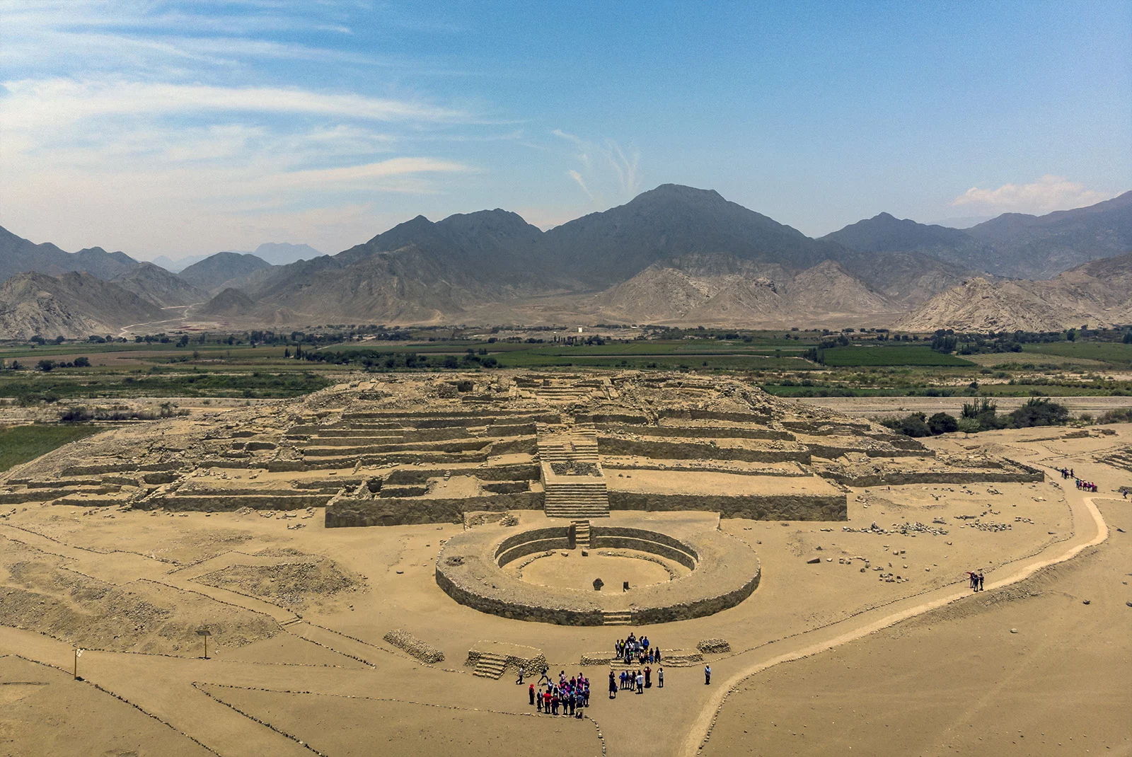
Caral ist die älteste bekannte Stadtsiedlung auf dem amerikanischen Kontinent. Die Siedlung liegt in Peru, etwa 200 km nördlich von Lima und 25 km landeinwärts der Pazifikküste im Tal des meist ausgetrockneten Río Supe. Seit Juni 2009 ist Caral-Supe Teil des UNESCO-Welterbes.
History
F 2000 - 1500 BC
History
E 2500 - 2000 BC
History
G 1500 - 1000 BC
History
H 1000 - 500 BC
Mesopotamian civilization
Civilization
埃兰(英语:Elam),又译以拦、厄蓝或伊勒姆,是亚洲西南部的古老君主制城邦国家,位于今天伊朗的西南部,波斯湾北部,底格里斯河东部,现为伊朗的胡齐斯坦及伊拉姆省。
埃兰是伊朗的最早文明,起源于伊朗高原以外的埃兰地区。一般认为埃兰国名出自境内哈尔答第城邦(意谓“神的国家”)。此名在《圣经》广为流传,故沿用至今。公元前三千年以前,在底格里斯河东岸建国,以善战的人民著称,圣经记载是诺亚儿子闪的儿孙及其后裔。
埃兰地区曾有许多君主制城邦国,其中最重要的有阿万(Awan)、苏萨、西马什(Simash)、安善(Anshan)等。
埃兰历史可以分为三个时期:古埃兰时期、中埃兰时期与新埃兰时期。
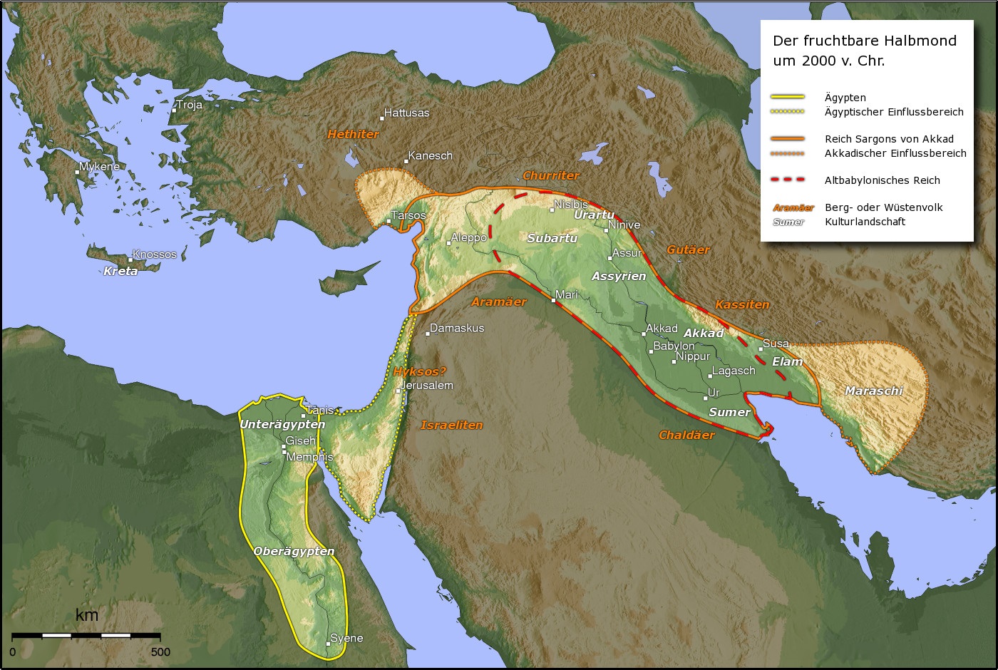
Das Reich Elam (sumerisch NIM.MAKI, akkadisch KURElammatum; griechisch Ἐλυμαία Elymaía oder Ἐλυμαΐς Elymaḯs) mit der Hauptstadt Susa (bzw. Schusim) lag östlich des Tigris in einem Gebiet, das heute Chusistan (im heutigen Iran) genannt wird. In seiner wechselvollen Geschichte – zwischen 3000 und 640 v. Chr. – wurde es immer wieder von den Mächten des Zweistromlandes (Sumerer, Akkader, Babylonier, Assyrer) erobert und fiel seinerseits häufig in Mesopotamien ein.
Der Landesname Elam entstammt der griechischen Bezeichnung Elymaía, die wiederum dem hebräischen Wort Elam entlehnt wurde. Die Eigenbezeichnung war Haltamti oder Hatamti und bedeutet „Land der Könige, Fürstenland“.
エラム (Elam) は古代オリエントで栄えた国家、または地方の名。紀元前3200年頃から紀元前539年までの間、複数の古代世界の列強国を出現させた。
エラムと呼ばれたのは、メソポタミアの東、現代のフーゼスターンなどを含むイラン高原南西部のザグロス山脈沿いの地域である。エラム人自身は自らをハルタミ (Haltami) と呼び、土地を指す際にはハルタムティ(Haltamti、後に訛ってアタムティAtamti)と呼んだ。シュメール語のエラムはこれの転訛したものである[1]。メソポタミアという古代文明世界の中心地に隣接したために、その文化的影響を強く受けたが、砂漠や湿地帯によって交通が困難であったために、政治的にはイラン高原地帯との関わりが深かった。エラム人は系統不明の言語エラム語を話す人々であり、メソポタミアでウルク古拙文字(楔形文字の元になったと考えられている絵文字)が発明されてから程なく、エラムでも原エラム文字と呼ばれる絵文字が発明された。この原エラム文字で書かれた文章は現在のアフガニスタンに近い地域からも見つかっており、エラム文化はイラン高原各地に影響を与えていたと考えられる。また、ほぼ同時代にエラム楔形文字も使われているが、それらの関係は全く解明されていない。メソポタミアの王朝はたびたびエラムに侵入して、これを支配下に置いた。一方でエラム人もメソポタミアへの介入を繰り返し、バビロニアの王朝をいくつも滅ぼしている。紀元前2000年紀に入ると、エラム人も楔形文字を使って記録を残すようになり、多くの情報がわかる。エラムの歴史で中心的役割を果たした都市はアンシャン、そしてスサである。スサを中心とした地方はギリシア人たちにはスシアナとよばれた。エラム人の残した文化や政治制度は、メディアやペルシアに大きな影響を及ぼした。
エラム人は、オリエントのほかの地域とは異なる独特の相続制度を持っていた。即ち、王位は親子ではなく、まず兄弟によって相続されていくのである。この相続制度はかなり後の時代にまで継承され、異民族の侵入によっても基本的に変化しなかった。
Elam (/ˈiːləm/; Elamite: ???????????????????? haltamti; Sumerian: ???????????? NIM.MAki; Hebrew: עֵילָם ʿÊlām) was an ancient Pre-Iranian civilization centered in the far west and southwest of what is now modern-day Iran, stretching from the lowlands of what is now Khuzestan and Ilam Province as well as a small part of southern Iraq. The modern name Elam stems from the Sumerian transliteration elam(a), along with the later Akkadian elamtu, and the Elamite haltamti. Elamite states were among the leading political forces of the Ancient Near East.[1] In classical literature Elam was also known as Susiana (US: /ˌsuːʒiˈænə/ UK: /ˌsuːziˈɑːnə/; Ancient Greek: Σουσιανή Sousiānḗ), a name derived from its capital Susa.[2]
Elam was part of the early urbanization during the Chalcolithic period (Copper Age). The emergence of written records from around 3000 BC also parallels Sumerian history, where slightly earlier records have been found.[3][4] In the Old Elamite period (Middle Bronze Age), Elam consisted of kingdoms on the Iranian plateau, centered in Anshan, and from the mid-2nd millennium BC, it was centered in Susa in the Khuzestan lowlands.[5] Its culture played a crucial role during the Persian Achaemenid dynasty that succeeded Elam, when the Elamite language remained among those in official use. Elamite is generally considered a language isolate unrelated to the much later arriving Persian and Iranic languages. In accordance with geographical and archaeological matches, some historians argue that the Elamites comprise a large portion of the ancestors of the modern day Lurs,[6][7] whose language, Luri, split from Middle Persian.
L'Élam est un ancien pays occupant la partie sud-ouest du plateau Iranien, autour des actuelles provinces du Khouzistan et du Fars, qui correspondent à ses deux principales régions, celle de Suse et celle d'Anshan/Anzan. Le pays élamite, attesté par des textes allant de la fin du IVe millénaire av. J.‑C. au Ier millénaire ap. J.-C., recouvrit des réalités géographiques et politiques qui différent pendant sa longue histoire. Il fut parfois divisé en plusieurs entités politiques, surtout jusqu'au IIIe millénaire av. J.‑C., mais aussi plusieurs fois par la suite, et il connut par contre des phases d'unification, sous l'impulsion de puissantes dynasties (notamment les Sukkalmah, Igehalkides, Shutrukides), surtout au IIe millénaire av. J.‑C. À partir du Ier millénaire av. J.‑C., l'Élam se réduit à sa partie occidentale, autour de la Susiane, la partie orientale étant occupée par les Perses, qui lui donnèrent le nom qu'elle a gardé depuis (Perse/Fars). Le pays élamite perdit son autonomie politique après son combat contre l'Assyrie et sa conquête par les Perses, même s'il semble avoir revécu plusieurs siècles plus tard, à travers le royaume d'Élymaïde. Des survivances de cet ancien pays et de son peuple semblent encore attestées jusqu'au début du IIe millénaire ap. J.-C.
L'histoire de l'Élam est difficilement dissociable de celle de la Mésopotamie voisine, qui exerça sur ces territoires une forte influence. Les sources mésopotamiennes sont essentielles pour redécouvrir la civilisation élamite, complétées par celles provenant de sites de la région, avant tout de Suse. Elles laissent apparaître un ensemble de régions hétérogènes présentant des originalités culturelles (perceptibles dans le culte religieux et l'art), mais beaucoup d'aspects restent obscurs en l'état actuel des connaissances scientifiques (par exemple l'organisation politique, les activités de production, la mythologie).
Elam è il nome convenzionale con cui si fa riferimento ad una civiltà sviluppatasi dal III al I millennio a.C. nell'area corrispondente all'attuale Iran occidentale, nelle regioni del Khuzistan e del Fars. I due centri di riferimento furono Susa, nell'estensione sud-orientale del bassopiano mesopotamico, e Anshan, identificato con il sito di Tall-i Malyan, nella piana di Marvdasht (a nord-est di Shiraz), la stessa in cui più tardi fu costruita Persepoli.
Elam (en elamita antiguo Haltamti;1 akkadio Elamtu; persa antiguo Hujiyā; persa moderno تمدن عیلام ―‘cultura de Elam’―), se situaba al este de Sumeria y Acad, en el actual suroeste de Irán. Los elamitas llamaban a su país Haltamti (en elamita tardío, Atamti), del cual sus vecinos acadios adaptaron como Elamtu. El alto Elam fue posteriormente más y más identificado por su baja capital, Susa, y geógrafos posteriores a Ptolomeo la llamaron Susiana. El término del antiguo persa Hujiyā sobrevive en el topónimo Juzestán, que es la provincia junto con la de Lorestán en la que se sitúan los restos del antiguo Elam. En diversos períodos existieron diversos imperios elamitas y en otros momentos estuvieron sometidos a imperios vecinos.
Excavaciones realizadas en Susa han proporcionado numerosos documentos escritos con caracteres cuneiformes que permiten reconstruir la más antigua historia y religión de los elamitas. El idioma elamita ―según se ha establecido a partir de los registros cuneiformes― no está relacionado con los cuatro grupos lingüísticos vecinos: camito-semítico, sumerio e indoeuropeo (en concreto, del grupo iranio temprano). Algunos expertos creen que la lengua de los elamitas está emparentada con las actuales lenguas drávidas del sur de la India (ver lenguas elamo-drávidas).23 Sin embargo, aun es oscura la relación de los elamitas con otras naciones conocidas.
Элам (также Елам[1]; шум. Ним, аккад. Эламту, самоназвание — Haltamti) — историческая область и древнее государство (3 тысячелетие — сер. VI в. до н. э.) на юго-западе современного Ирана (провинции Хузестан и Лурестан).

2700年前,先知以赛亚切慕神的荣耀显现,从心底发出这样的呼喊:“草必枯干,花必凋残,惟有我们神的话,必永远立定。”回首人类所走过的漫长而又短暂的历史,我们所看到的无不印证了这个千古不变的真理,我们一样会禁不住内心的激动,发出同样的感慨。
早在3500年前,当以色列民还在旷野漂流的时候,摩西就已经跨越时空的界限,看到了犹太民族多灾多难、最终却要起死回生、欢呼雀跃的历史。当时以色列 民尚未进入应许之地,摩西已经预见到因为耶和华在何烈山,从火中对这些百姓说话的那日,他们没有看见什么形象(申4:15),将来进入迦南地以后必定会陷 入拜偶像的罪中(申4:25)。这位带领以色列民脱离了埃及的奴役和压制的伟大领袖,居然一口气描绘出了以色列人以后数千年的悲惨命运。“我今日呼天唤地 向你们作见证:你们必在过约旦河得为业的地上,速速灭尽!你们不能在那地上长久,必尽行除灭。耶和华必使你们分散在万民中,在他所领你们到的万国里,你们 剩下的人数稀少。”“耶和华必使你败在仇敌面前,你从一条路去攻击他们,必从七条路逃跑。你必在天下万国中抛来抛去。”“你在耶和华领你到的各国中,要令 人惊骇、笑谈、讥诮。”“耶和华必使你们分散在万民中,从地这边到地那边,你必在那里事奉你和你列祖素不认识木头石头的神。在那些国中,你必不得安逸,也 不得落脚之地;耶和华却使你在那里心中跳动,眼目失明,精神消耗。你的性命必悬悬无定,你昼夜恐惧,自料性命难保。你因心里所恐惧的,眼中所看见的,早晨 必说,巴不得到晚上才好;晚上必说,巴不得到早晨才好。” (申4:26-27;28:25,37,64-67)
(来源:爱筵网站http://www.aiyan.org/)
British Museum
History
H 1000 - 500 BC
Greece
Griechische Keramik
Minoische Keramik
Griechische Keramik
Mykenische Keramik
 Art
*Greco-Roman Art
Art
*Europe's ceramics and porcelain
Art
*Greek epoch
Art
WB - Western art 15th century BC - 5th century AD
Art
WB - Western art 15th century BC - 5th century AD
National Archaeological Museum Athens
Art
*Greco-Roman Art
Art
*Europe's ceramics and porcelain
Art
*Greek epoch
Art
WB - Western art 15th century BC - 5th century AD
Art
WB - Western art 15th century BC - 5th century AD
National Archaeological Museum Athens

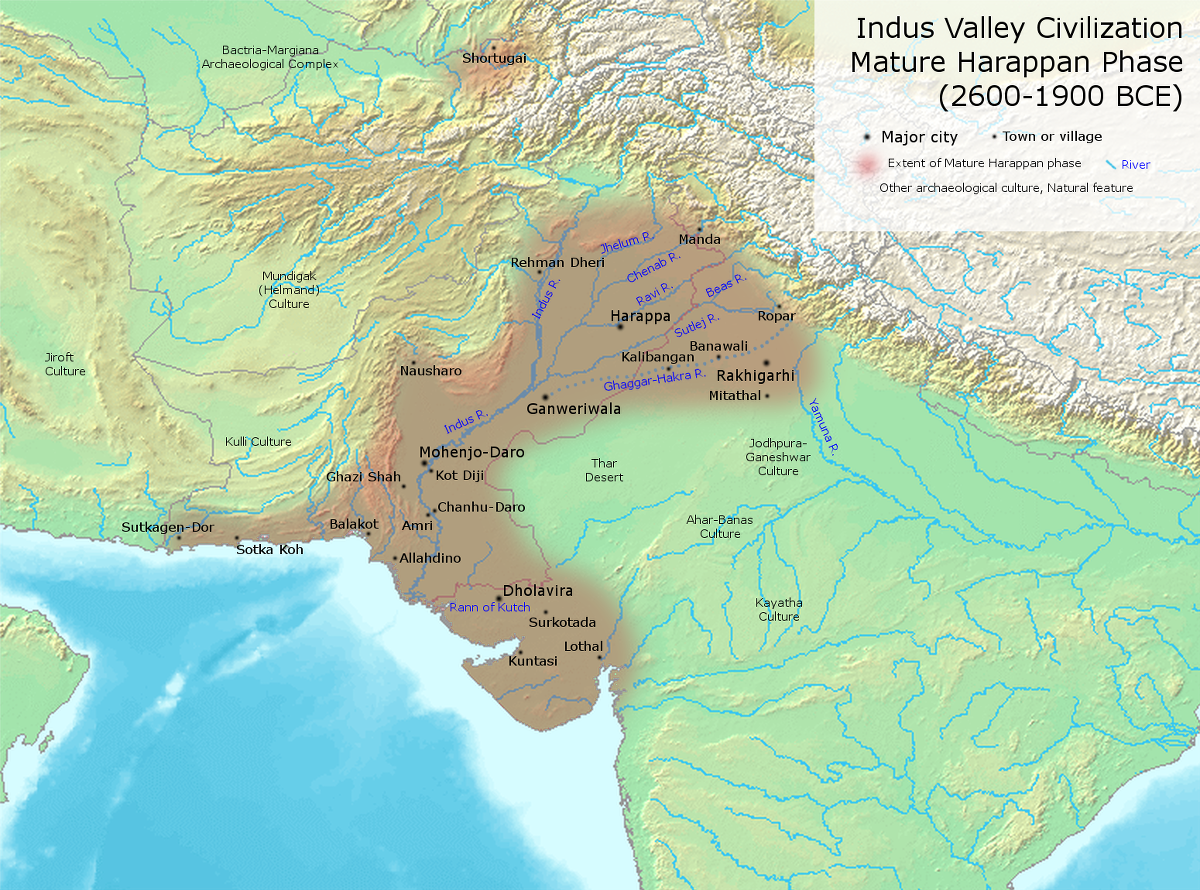
Die bronzezeitliche Indus-Kultur oder Indus-Zivilisation war eine der frühesten städtischen Zivilisationen. Sie entwickelte sich etwa in den Jahren 2800–1800 v. Chr. entlang des Indus im Nordwesten des indischen Subkontinents. Die Indus-Kultur erstreckte sich über fast das gesamte heutige Pakistan sowie Teile Indiens und Afghanistans, insgesamt umfasste sie 1.250.000 km² und damit eine größere Landfläche als das antike Ägypten und Mesopotamien zusammen. Sie war neben diesen eine der drei frühesten Zivilisationen der Welt.
Sie wird teilweise auch Harappa oder Harappa-Kultur genannt, nach Harappa, einem der Hauptausgrabungsplätze am Ravi. Eine weitere alternative Benennung dieser Kultur lautet Sindhu-Sarasvati-Zivilisation; hinter dieser Bezeichnung steht die Theorie, dass sie eine in der vedischen Literatur erwähnte Zivilisation sei. Möglicherweise ist sie auch mit dem sumerischen Meluha zu identifizieren.
Bis heute sind über 1050 Fundorte identifiziert, hauptsächlich entlang des Indus. Zusätzlich gibt es Hinweise auf einen anderen großen Fluss östlich des Indus, der heute ausgetrocknet ist und der antike Ghaggra-Hakra oder Sarasvati gewesen sein könnte. Über 140 antike Städte und Siedlungen wurden an seinem Lauf gefunden. Die beiden größten urbanen Zentren der Harappa-Kultur waren wohl Harappa und Mohenjo-Daro, daneben gab es noch große Städte bei Dholavira, Ganweriwala, Lothal und Rakhigarhi. Zu ihrer Blütezeit zählte die Indus-Kultur vermutlich über fünf Millionen Menschen.
Diese frühe indische Kultur kannte bereits Architektur und eine regelmäßige Städteplanung einschließlich gepflasterter Straßen mit Straßenablauf (Gullys). Sie entwickelte zum ersten Mal in der Geschichte der Menschheit den gebrannten Ziegel mit den perfekten, noch heute gebräuchlichen Proportionen 1:2:4, der als Einhandziegel in allen Richtungen beliebig addierbar ist.
Möglicherweise besaß sie auch eine Schrift; ob aber die sogenannte Indus-Schrift tatsächlich eine Schrift ist, wird in Fachkreisen bisher kontrovers diskutiert.
古印度文明時期,也称哈拉帕文明(harappa)时期,是指世界四大文明之一的古印度,約公元前2300年至前1300年之時期。
印度河流域文明发生晚于两河流域文明、尼罗河流域文明,但早于商朝。考古专家在印度河流域发现摩亨约达罗和哈拉帕两个古代城市遗址,发现了大量石器、青铜器、印章和农作物遗迹,估计城市人口都在4万以上。
两个城市的中心都有一个人工堆成的土墩,作用未知,考古学家猜测这可能是城市的中心。城市建筑以卫城为中心呈网格状分布,有市政建筑、市场、作坊、储存区、民居和神庙。每座民居都围着一个院子建成,有几个房间、一间厕所和一口水井。建筑用基本材料是从烧木头的窑里制出的土砖。在摩亨佐-达罗的卫城上建造了一个大浴池,有私人浴池、会所等。
印度河流域的农民种植大麦、小麦、棉花、瓜和椰枣。他们还驯养大象和水牛在田里干活。这一地区有许多手艺精湛的制陶人,他们用陶轮制作陶器,这在当时是一项崭新的技术。哈拉帕人使用石器,并用青铜制作刀、武器、碗和雕像。他们建立了发达的废物处理系统,包括有盖板的排水系统和倒垃圾的斜槽。
遗址中有许多天秤和砝码,说明他们有一套度量衡制度好配合其繁荣的商业贸易。而印度河流域文明更证明与古美索不达米亚,阿富汗,缅甸甚至和古中国都有商业往来。
印度河文明持续了800年,尚未有人知道它是如何结束的,但是有几种说法:河水泛滥、瘟疫、贸易或经济或国内秩序崩溃等等。
インダス文明(インダスぶんめい、Indus Valley civilization)は、インド・パキスタン・アフガニスタンのインダス川および並行して流れていたとされるガッガル・ハークラー川周辺に栄えた文明である。これら各国の先史文明でもある(インドの歴史、アフガニスタンの歴史も参照)。崩壊の原因となったという説のあった川の名前にちなんでインダス文明、最初に発見された遺跡にちなんでハラッパー文明とも呼ばれる[1]。
狭義のインダス文明は、紀元前2600年から紀元前1800年の間を指す。インダス文明の遺跡は、東西1500km、南北1800kmに分布し、遺跡の数は約2600におよぶ。そのうち発掘調査が行われた遺跡は、2010年時点でインド96、パキスタン47、アフガニスタン4の合計147となっている[2]。
The Indus Valley Civilisation (IVC) was a Bronze Age civilisation in the northwestern regions of South Asia, lasting from 3300 BCE to 1300 BCE, and in mature form from 2600 BCE to 1900 BCE.[1] Along with ancient Egypt and Mesopotamia it was one of three early civilisations of the Old World, and of the three, the most widespread, extending from what today is northeast Afghanistan to Pakistan and northwest India.[2][note 1] It flourished in the basins of the Indus River, which flows through the length of Pakistan, and along a system of perennial, mostly monsoon-fed, rivers that once coursed in the vicinity of the seasonal Ghaggar-Hakra river in northwest India and eastern Pakistan.[1][3] Aridification of this region during the 3rd millennium BCE may have been the initial spur for the urbanisation associated with the civilisation, but eventually also reduced the water supply enough to cause the civilisation's demise, and to scatter its population eastward.[4][5][3][6]
The civilisation's cities were noted for their urban planning, baked brick houses, elaborate drainage systems, water supply systems, clusters of large non-residential buildings, and new techniques in handicraft (carnelian products, seal carving) and metallurgy (copper, bronze, lead, and tin). [7] Its large urban centres of Mohenjo-daro and Harappa very likely grew to containing between 30,000 and 60,000 individuals,[8][note 2] and the civilisation itself during its florescence may have contained between one and five million individuals.[9][note 3]
The Indus civilisation is also known as the Harappan Civilisation, after its type site, Harappa, the first of its sites to be excavated in the 1920s in what was then the Punjab province of British India and now is Pakistan.[10][note 4] The discovery of Harappa and soon afterwards Mohenjo-Daro was the culmination of work beginning in 1861 with the founding of the Archaeological Survey of India during the British Raj.[11] There were however also earlier and later cultures often called Early Harappan and Late Harappan in the same area; for this reason, the Harappan civilisation is sometimes called the Mature Harappan' culture to distinguish it from these cultures. By 2002, over 1,000 Mature Harappan cities and settlements had been reported, of which just under a hundred had been excavated,[12][note 5][13][14][note 6] mainly in the general region of the Indus and Ghaggar-Hakra Rivers and their tributaries; however, there are only five major urban sites at the peak of the settlement hierarchy:[15][note 7] Harappa, Mohenjo-daro (UNESCO World Heritage Site), Dholavira, Ganeriwala in Cholistan and Rakhigarhi.[16][note 8] The early Harappan cultures were preceded by local Neolithic agricultural villages, from which the river plains were populated.[17][18]
The Harappan language is not directly attested, and its affiliation is uncertain since the Indus script is still undeciphered.[19] A relationship with the Dravidian or Elamo-Dravidian language family is favoured by a section of scholars.[20][21]
La civilisation de la vallée de l'Indus (vers 2600 av. J.-C. – vers 1900 av. J.-C.), ou civilisation harappéenne, du nom de la ville antique de Harappa, est une civilisation de l'Âge du bronze, dont le territoire s'étendait autour de la vallée du fleuve Indus, dans l'ouest du sous-continent indien (le Pakistan moderne et ses alentours). Les raisons de son émergence, de sa prospérité rayonnante durant sept siècles, puis de son déclin brutal, sont mal connues et restent débattues, ainsi que son influence, probable, sur la culture hindoue antique.
Oubliée jusqu’à sa découverte dans les années 1920, la civilisation de l’Indus se classe, avec celles de la Mésopotamie et de l’Égypte antique, comme l’une des toutes premières civilisations de l'histoire, celles-ci étant définies par l'apparition de villes, puis de l’écriture.
Si la civilisation de l’Indus n’est pas considérée comme la première civilisation antique, la Mésopotamie et l’Égypte ayant développé des villes un peu plus tôt, elle est par contre celle qui connait à son époque la plus grande extension géographique. À ce jour, sur les 1 052 sites qui ont été découverts, plus de 140 se trouvent sur les rives du cours d'eau saisonnier Ghaggar-Hakra. D’après certaines hypothèses, ce système hydrographique, autrefois permanent, arrosait la principale zone de production agricole de la civilisation de l’Indus.
La plupart des autres sites se situent le long de la vallée de l’Indus et de ses affluents, mais on en trouve aussi à l’ouest, jusqu’à la frontière de l’Iran, à l’est jusqu’à Delhi, au sud jusque dans le Maharashtra, et au nord jusqu’à l’Himalaya. Parmi ces sites, on compte de nombreuses villes comme Dholavira, Ganweriwala, Mehrgarh, Harappa, Lothal, Mohenjo-daro et Rakhigarhi. À son apogée, sa population pourrait avoir dépassé cinq millions de personnes.
Malgré toutes ses réalisations, cette civilisation est très mal connue. Son existence même a été oubliée jusqu’au XXe siècle. Son écriture reste indéchiffrée et on ne sait pas si elle a un lien quelconque avec l’écriture brahmi, ce qui semble peu probable au regard des connaissances actuelles. Parmi les mystères que cette civilisation recèle, trois questions au moins sont fondamentales :
- formait-elle un État ou un ensemble de cités-états ?
- quels étaient ses moyens de subsistance ?
- quelles sont les causes de sa disparition soudaine et dramatique, à partir du XIXe siècle av. J.-C. ?
La langue utilisée par ses membres et le nom qu’ils se donnaient restent à ce jour inconnus.
La civiltà della valle dell'Indo (c. 3300–1500 a.C., fiorita 2600–1900 a.C.) fu una civiltà antica, estesa geograficamente soprattutto lungo il fiume Indo nel subcontinente indiano, ma anche lungo il Sarasvati, un fiume dell'India ormai prosciugato.
Nel mondo anglosassone viene citata come "civiltà dell'Indo-Sarasvati", in riferimento alla civiltà descritta nei Veda e che si sarebbe sviluppata lungo i due fiumi. È anche conosciuta come "civiltà di Harappa", dal primo sito conosciuto, scoperto nel 1857, ma scavato soltanto dagli anni venti del Novecento.
La cultura del valle del Indo fue una civilización de la Edad del Bronce, que se desarrolló desde c. 3300 a. C. hasta 1300 a. C. a lo largo del valle del río Indo, en Afganistán, Pakistán y el noroeste de la India. Abarcaba cerca de un centenar de asentamientos y dos ciudades importantes: Harappa y Mohenjo-Daro, ambos sitios en Pakistán. En conjunto comprendía el área más extensa de todas las civilizaciones antiguas, más de un millón de kilómetros cuadrados, y atravesó varios periodos, siendo su máximo esplendor entre el 2600 y el 1900 a. C.
Al igual que las civilizaciones de Mesopotamia y Egipto, dependía de su río. Como el Nilo, el Indo se desbordaba todos los años, inundando extensas zonas y depositando sedimentos fértiles. Este inmenso potencial agrícola fue la base sobre la cual se desarrolló el urbanismo en torno al río Indo.
Con las culturas prehistóricas del valle del Indo se prepara el primer capítulo de la historia de la India. Se trata de un largo periodo prehistórico, probado por testimonios líticos. Por otra parte, se pueden encontrar vestigios prehistóricos hasta el I milenio a. C., es decir, hasta un tiempo en que la península ya había entrado en la historia. En sentido estricto, las culturas del Indo pertenecen a la prehistoria ya que solamente han dejado restos arqueológicos sin documentos literarios, pero para apreciar la historia india hace falta tomar en consideración estas culturas urbanas prearias.
И́ндская или Хара́ппская цивилизация — третья[* 1] по времени появления древневосточная цивилизация бронзы[1], после египетской и месопотамской. Из всех трёх она занимала наибольшую площадь, превосходя в 2 раза суммарную площадь двух остальных[2][3]. Индская цивилизация относительно быстро пришла в упадок, пережив расцвет между 2600—1900 годами до нашей эры, см. Засуха 2200 года до н. э..
Хараппская цивилизация развивалась в долине реки Инд в 3300—1300 годах до нашей эры[4]. Наиболее значительные центры — Ракхигархи (350 га), Мохенджо-Даро (300 га)[5], Хараппа (150 га), Лотхал (60 га) и Дхолавира — 47 гектаров.[6]. Население в годы расцвета составляло около 5 миллионов человек и состояло из эламито-дравидов, без примеси индоевропейцев[7]. Зрелый период развития Индской цивилизации шёл с 2600 до 1900 лет до нашей эры. Простиралась на территориях нынешних Афганистана, Пакистана и Северо-Западной Индии.
В шумерских текстах хараппская цивилизация предположительно носила название «Мелухха»[8].
В течение III-го тысячелетия до нашей эры началась аридизация — постепенное истощение водных ресурсов региона, где находилось государство. Возможной причиной аридизации археологи называют возросшую урбанизацию в регионе и постепенное осушение почв и рек. В итоге это могло привести к упадку государства. При этом, после упадка, население ушло на Восток.
Первые данные о существовании доарийской цивилизации в западной Индии опубликовал в XIX веке Александр Каннингем. Окончательно существование индской цивилизации было установлено в 1921—1922 годах экспедицией во главе с Джоном Маршаллом.
На пике развития индская цивилизация имела население свыше 5 миллионов человек. Жители долины реки Инд разработали ряд новых ремёсел — обработку сердолика, обработку кости, металлургию бронзы, меди, свинца и олова. Города хараппской цивилизации отличаются чётким планированием построек. Строительный материал — обожжённый кирпич из глины. Освоены и использовались сложные дренажные системы, системы водоснабжения и целые кластеры крупных нежилых зданий.
При раскопках городов были найдены как детские игрушки, так и небольшое количество оружия, что указывает на не сильную милитаризацию государства и относительно мирные периоды существования. Ставка в развитии была сделана на торговлю с далёкими землями, дальше чем Вавилон, Шумер и южная Месопотамия. На развитую торговлю указывают многочисленные печати, украшенные животными и мифическими существами.
Названия «цивилизация Инд» и «цивилизация Хараппы» — равнозначны в археологической литературе[источник не указан 150 дней], хотя термин «Хараппа» может ввести в заблуждение, так как это обозначение дано по названию современного городка Хараппа, где располагается хронологически первая археологическая площадка, раскопанная еще в 1920-е годы. Вскоре был обнаружен и исследован Мохенджо-Даро, что привело к сенсационным открытиям. Данные памятники относятся к зрелому этапу хараппской цивилизации и отличаются от предшествующих и последующих культур, называемых ранней хараппской и поздней хараппской культурами. Ранней хараппской культуре предшествовали местные неолитические поселения сельскохозяйственного типа.
К 2008 году было найдено 1 022 города и поселения, главным образом в районе рек Инд и Гхаггар-Хакра и их притоков. Из них 406 объектов найдены на территории нынешнего Пакистана и 616 в Индии. Раскопаны и изучены — 96 объектов. Среди этих 96 объектов значатся крупные городские центры, в том числе Хараппа, Мохенджо-Даро (объект Всемирного наследия Юнеско), Дхолавира, Ганеривала[en], Ракхигархи.
Язык государства не имеет точной идентификации, его генеалогическая принадлежность пока не ясна. Связи хараппского языка и дравидийских и эламо-дравидийских языков изучены недостаточно.[9]