Deutsch-Chinesische Enzyklopädie, 德汉百科
       
German — Chinese
Geography Strait of the world

斯卡格拉克海峡
This image, video or audio may be copyrighted. It is used for educational purposes only. If you find it, please notify us byand we will remove it immediately.
索伦特海峡
http://www.net4info.de/photos/cpg/albums/userpics/10002/Solent.jpg
This image, video or audio may be copyrighted. It is used for educational purposes only. If you find it, please notify us byand we will remove it immediately.
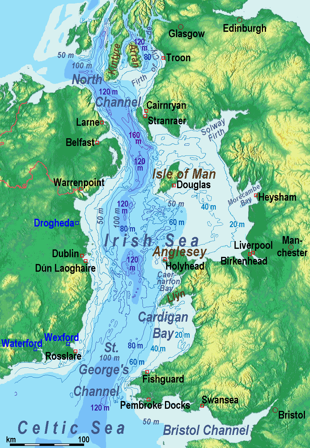
圣乔治海峡/St George´s Channel
This image, video or audio may be copyrighted. It is used for educational purposes only. If you find it, please notify us byand we will remove it immediately.
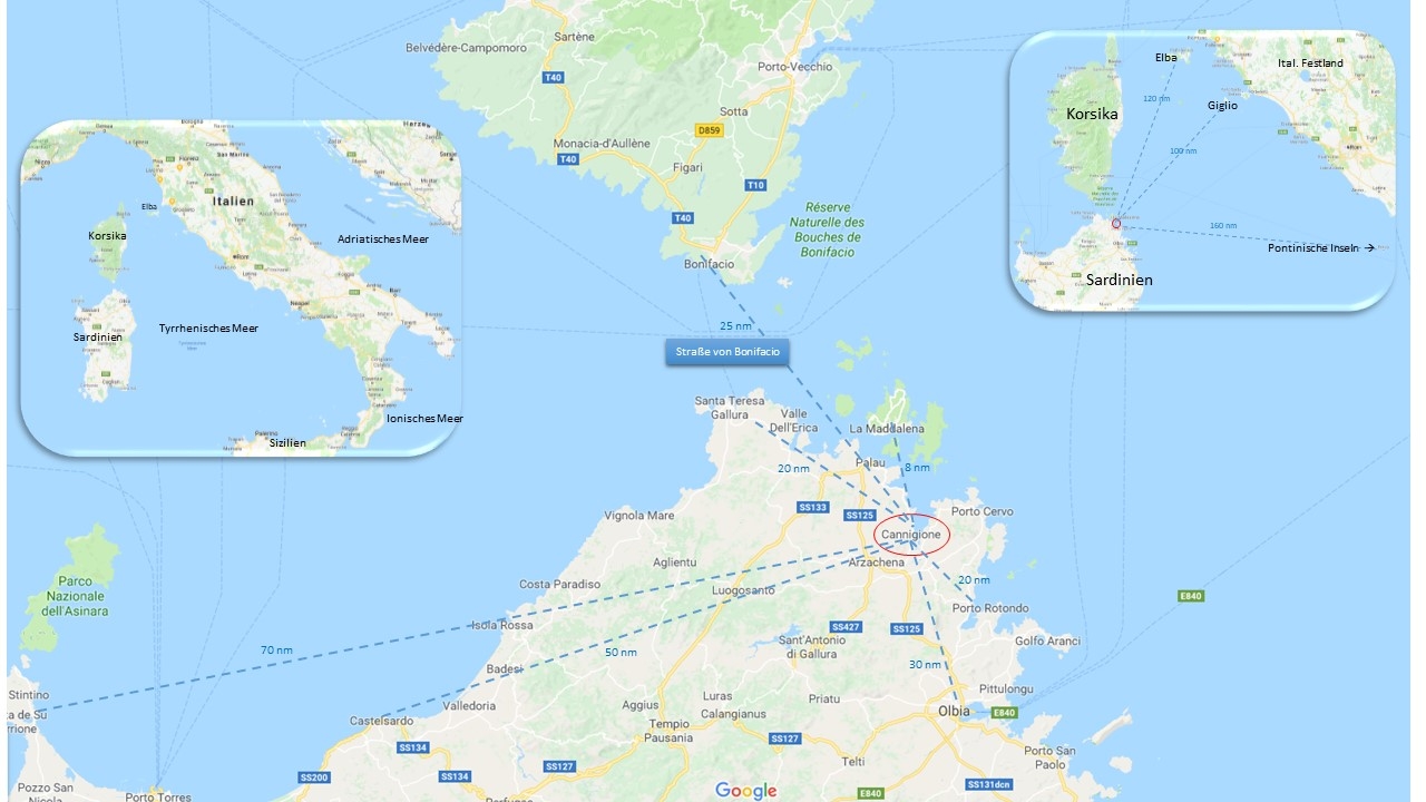
博尼法乔海峡/Bocche di Bonifacio
This image, video or audio may be copyrighted. It is used for educational purposes only. If you find it, please notify us byand we will remove it immediately.
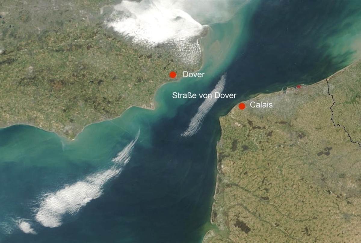
多佛尔海峡/Strait of Dover
This image, video or audio may be copyrighted. It is used for educational purposes only. If you find it, please notify us byand we will remove it immediately.
直布罗陀海峡
 http://www.net4info.de/photos/cpg/albums/userpics/10002/Strasse_von_Gibraltar.png

 直布罗陀海峡(Strait of Gibraltar , 拉丁语作Fretum Herculeum)是沟通地中海大西洋的海峡。位于西班牙最南部和非洲西北部之间(西经5度36分,北纬35度57分),长58公里(36哩);最窄处在西班牙的马罗基(Marroqui)角和摩洛哥的西雷斯(Cires)角之间,宽仅13公里(8哩)。

This image, video or audio may be copyrighted. It is used for educational purposes only. If you find it, please notify us byand we will remove it immediately.
霍尔木兹海峡/Strait of Hormuz
霍尔木兹海峡是连接波斯湾印度洋的海峡,亦是唯一一个进入波斯湾的水道。海峡的北岸是伊朗,有阿巴斯港,海峡的南岸是阿曼,海峡中间偏近伊朗的一边有一个大岛叫做格什姆岛,隶属于伊朗。霍尔木兹海峡自古以来就是东西方国家间文化、经济、贸易的枢纽,16世纪初葡萄牙开始入侵该地区,其后成为英国荷兰法国俄国等争夺的重要目标。作为当今全球最为繁忙的水道之一,霍尔木兹海峡又被称为世界重要的咽喉,具有十分重要的经济和战略地位,是海湾地区石油输往世界各地的唯一海上通道。霍尔木兹海峡被誉为西方的“海上生命线”。
This image, video or audio may be copyrighted. It is used for educational purposes only. If you find it, please notify us byand we will remove it immediately.
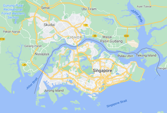
柔佛海峽 柔佛海峡
This image, video or audio may be copyrighted. It is used for educational purposes only. If you find it, please notify us byand we will remove it immediately.
刻赤海峡/Керченский пролив/Керченська протока/Keriç boğazı/Strait of Kerch
http://www.net4info.de/photos/cpg/albums/userpics/10001/Strasse_von_Kertsch.png
This image, video or audio may be copyrighted. It is used for educational purposes only. If you find it, please notify us byand we will remove it immediately.
望加锡海峡/Makassar Strait

This image, video or audio may be copyrighted. It is used for educational purposes only. If you find it, please notify us byand we will remove it immediately.
馬六甲海峽 马六甲海峡
Die Straße von Malakka ist eine Meerenge in Südostasien zwischen der Malaiischen Halbinsel und der Insel Sumatra. Sie verbindet zusammen mit der an ihrem östlichen Ende gelegenen Straße von Singapur den Indischen Ozean und das Südchinesische Meer. Sie ist eine der am stärksten befahrenen Wasserstraßen der Welt und hat eine große geostrategische Bedeutung.

马六甲海峡又译做麻六甲海峡(英语:Strait of Malacca;马来语:Selat Melaka)是位于马来半岛与苏门答腊岛之间的海峡。马六甲海峡呈东南-西北走向。它的西北端通印度洋的安达曼海,东南端连接南中国海。海峡全长约1080公里,西北部最宽达370公里,东南部最窄处只有37公里,是连接沟通太平洋与印度洋的国际水道。马六甲海峡还被誉为日本的“海上生命线”。(注意:被西方国家誉为海上生命线的是“霍尔木兹海峡”),海峡现由新加坡、马来西亚和印度尼西亚三国共同管辖。

马六甲海峡(英语:Strait of Malacca;马来语:Selat Melaka)是位于马来半岛苏门答腊岛之间的海峡

马六甲海峡呈东南西北走向。它的西北端通印度洋安达曼海,东南端连接南中国海(南海)。海峡全长约1080公里,西北部最宽达370公里,东南部最窄处只有2.8公里,[2]是连接沟通太平洋印度洋国际水道。在界限方面,马六甲海峡西抵泰国布吉岛与印尼苏门答腊岛间,东至马来亚丹绒比艾与印尼廖内群岛之间(经新加坡圣约翰岛与印尼安乐岛间水道衔接新加坡海峡)。

马六甲海峡因沿岸有马来亚古城马六甲而得名。海峡现由新加坡泰国马来西亚印度尼西亚4国共管。海峡处于赤道无风带,全年风平浪静的日子很多。海峡底质平坦,多为泥沙质,水流平缓。

Die Straße von Malakka ist eine Meerenge in Südostasien zwischen der Malaiischen Halbinsel und der Nordostküste von Sumatra. Sie verbindet die Andamanensee und das Südchinesische Meer mit der Straße von Singapur. Sie liegt vollständig über dem südostasiatischen Festlandsockel und ist somit maximal etwa 200 Meter tief.[1]

Von dem Stadtstaat Singapur im Süden bis zum nördlichen Küstenbereich von Sumatra beträgt die Distanz etwa 930 Kilometer bei einer Breite zwischen 38 und 393 Kilometern. Am südlichen Ende befinden sich zwischen Singapur, den indonesischen Riau-Inseln und der Ostküste von Sumatra zahlreiche Durchfahrten mit teils erheblich geringerer Breite und an der seichtesten Stelle einer Tiefe von nur etwa 25 Metern.
This image, video or audio may be copyrighted. It is used for educational purposes only. If you find it, please notify us byand we will remove it immediately.
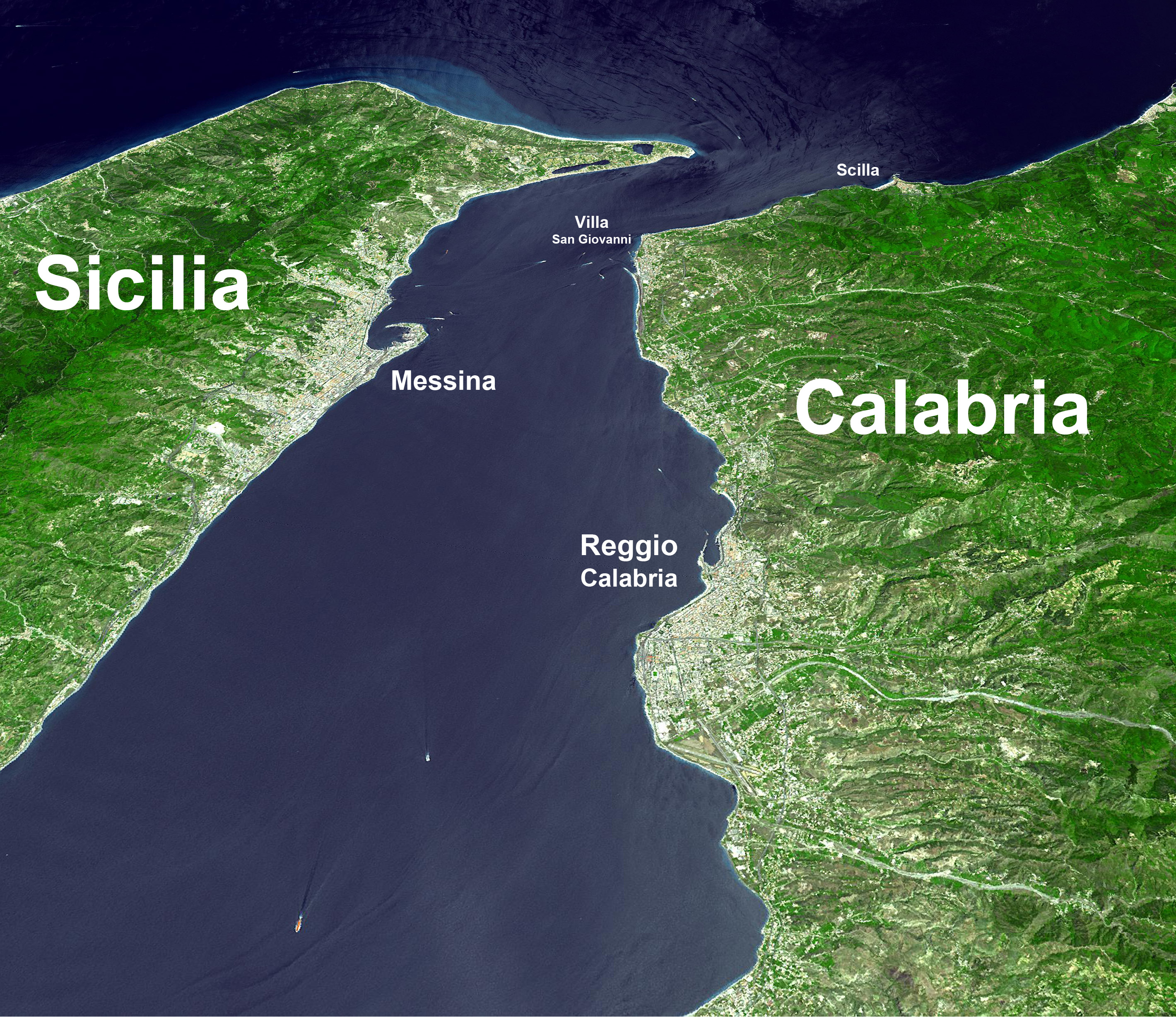
墨西拿海峡
This image, video or audio may be copyrighted. It is used for educational purposes only. If you find it, please notify us byand we will remove it immediately.