
Deutsch-Chinesische Enzyklopädie, 德汉百科
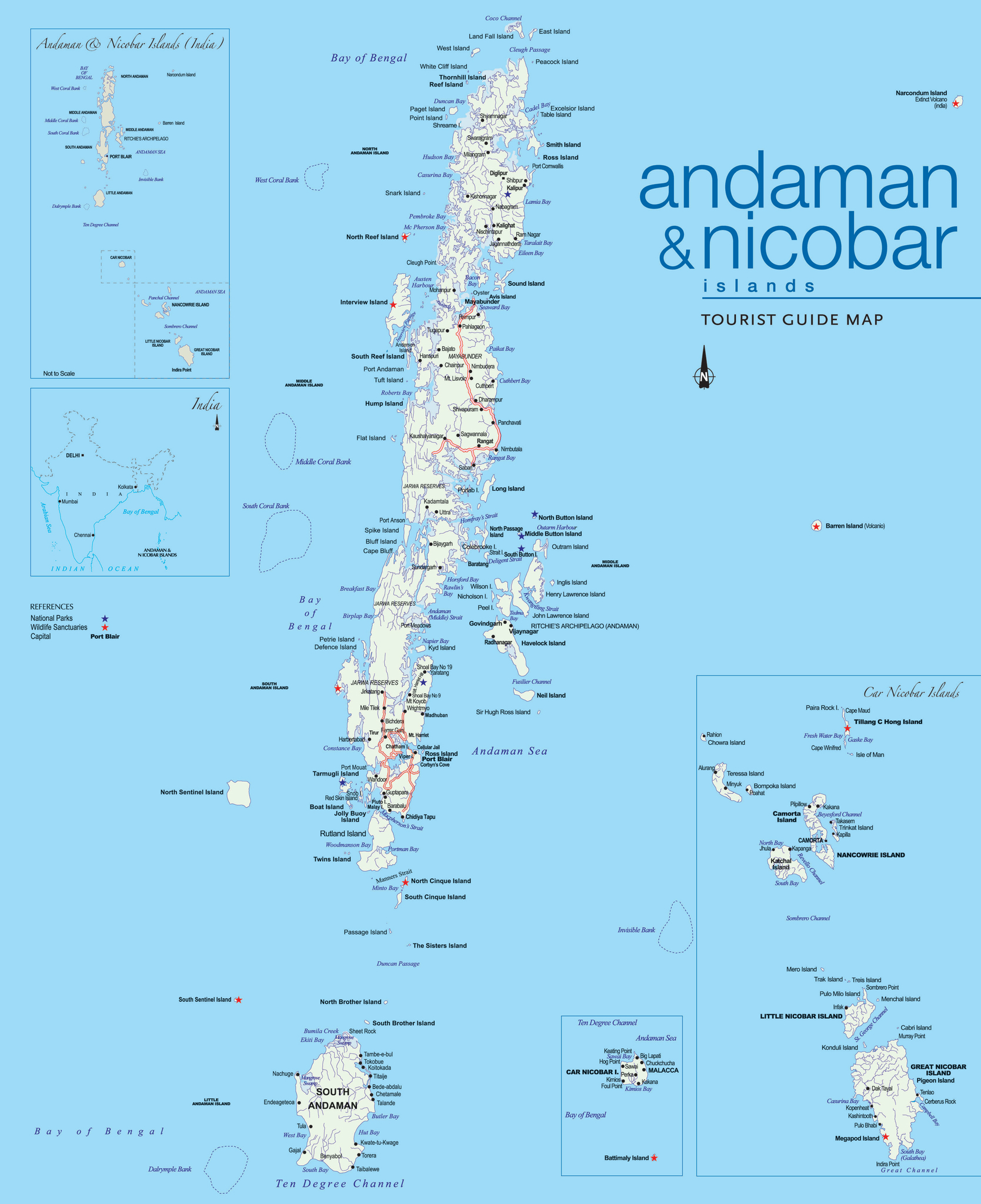
Die Andamanen und Nikobaren (Hindi: अंडमान और निकोबार द्वीप समूह; englisch: Andaman and Nicobar Islands) sind ein indisches Unionsterritorium, 1.255 km südöstlich von Kolkata und 1.190 km östlich von Chennai.
Sie erstrecken sich von 6°45' bis 13°41' Nord, ungefähr entlang des 93. östlichen Längengrades westlich der thailändischen Küste und nordwestlich von Sumatra. Die am 10. Breitengrad verlaufende Zehn-Grad-Straße (engl.: Ten Degree Channel) trennt die nördlichen Andamanen von den südlichen Nikobaren. In der Hauptstadt Port Blair lebt etwa ein Viertel der etwa 380.581 Einwohner (Stand 2011).
Das Andamanische Meer mit dem Nord-Preparis-Kanal trennt das Territorium vom östlich gelegenen Myanmar. Zum Staatsvogel wurde die Andamanen-Kuckuckstaube (Macropygia rufipennis) gewählt, das Staatstier ist der Dugong, der einheimische Padauk-Baum repräsentiert die Flora.
安达曼-尼科巴群岛(英语:Andaman and Nicobar Islands;孟加拉语:আন্দামান ও নিকোবর দ্বীপপুঞ্জ;泰米尔语:அந்தமான் நிக்கோபார் தீவுகள்;印地语:अंडमान और निकोबार द्वीपसमूह;泰卢固语:అండమాన్ నికోబార్ దీవులు)是印度的中央直辖区,处于孟加拉湾中,缅甸以南,距离印度大陆800公里。安达曼群岛(群岛的北边)的安达曼语系语言独成一体,和亚洲大陆的语言没有同源关系。尼科巴群岛(群岛的南边)的传统语言尼科巴语是南亚语系里非常独特的语言。

Die Batu-Inseln (indonesisch Kepulauan Batu, wörtlich „Inselgruppe Fels“) sind eine Inselgruppe vor der Westküste Sumatras im Malaiischen Archipel und gehören zum Regierungsbezirk Nias Selatan in der indonesischen Provinz Nordsumatra.
Sie bilden das Glied einer Inselkette, die sich zwischen 5° nördlicher und 4° südlicher Breite von Simeulue bis Enggano hinzieht – im Süden liegt Siberut (die nördlichste der Mentawai-Inseln), im Norden Nias.
Die Batu-Inseln sind zusammen etwa 1.154 km² groß. Neben den 48 kleineren Inselchen, davon nur etwa zwanzig bewohnt, gehören dazu drei etwa gleich große Hauptinseln:
- Pini mit einer Fläche von 312,7 km² und der höchsten Erhebung von 82 m[1]
- Tanahmasa mit einer Fläche von 344,3 km² und der höchsten Erhebung von 204 m[2]
- Tanahbala mit einer Fläche von 467,6 km² und der höchsten Erhebung von 302 m[3]
Die Bevölkerung hatte früher zahlreiche Bindungen nach Nias.
Die rund 10.500 Einwohner sind hauptsächlich Malaien.[4] Verwaltungszentrum ist Pulautelo auf der gleichnamigen Insel Telo.
Der Äquator durchquert den Norden Tanahmasas und den Süden Pinis.
巴都群岛是印度尼西亚的群岛,位于苏门答腊西面尼亚斯岛和西比路岛之间的印度洋,由北苏门答腊省管辖,三个主要岛屿皮尼岛、塔纳马萨岛和塔纳巴拉岛面积相若,另有48个较小岛屿,其中少于一半的岛屿有人居住。

Borneo ist eine Insel im Malaiischen Archipel in Südostasien. Mit einer Fläche von knapp 752.000 km² ist sie nach Grönland und Neuguinea die drittgrößte Insel der Welt und die größte Insel Asiens und vergleichsweise doppelt so groß wie Deutschland. Borneo ist aufgeteilt zwischen den drei Staaten Indonesien, Malaysia und Brunei.
In Indonesien wird die ganze Insel Kalimantan genannt.[1] Teilweise wird die Bezeichnung Kalimantan im engeren Sinne auf den indonesischen Teil der Insel bezogen, unter anderem wegen der Benennung der fünf indonesischen Provinzen auf Borneo: Kalimantan Barat (West), Kalimantan Selatan (Süd), Kalimantan Timur (Ost), Kalimantan Utara (Nord) und Kalimantan Tengah (Zentral) ergeben insgesamt Kalimantan im Sinne von „indonesische Provinzen auf Borneo“.
婆罗洲(马来语:Borneo),印尼称之为加里曼丹岛(印尼语:Kalimantan),是世界第三大岛,亦是亚洲第一大岛,面积743,330平方公里,仅次于格陵兰及新几内亚。婆罗洲是被管辖国家最多的岛屿(三个),也是唯一被三个普遍受承认的国家管辖的岛屿,(塞浦路斯岛主权有争议)。现全境由印尼、马来西亚联邦及文莱三国管辖,而菲律宾曾宣称有沙巴部分的主权。

崇明岛是中国国家地质公园,公园范围涵盖整个崇明岛,东西长约76公里,南北宽约13~18公里,面积约1200平方公里。崇明岛有“长江门户、东海瀛洲”之称。全岛三面环江,一面临海,东濒东海,南与上海浦东新区、宝山区及江苏省太仓隔水相望,西、北以长江与江苏省海门、启东一衣带水。全岛面积1225平方公里,东西长80公里,南北宽13至18公里,为中国大陆地区实际管辖之第二大岛,面积次于海南岛。岛上地势平坦,无山岗丘陵,西北部和中部稍高,西南部和东部略低
Chongming Dao (chinesisch 崇明島 / 崇明岛, Pinyin Chóngmíng Dǎo) ist mit 1.267 km² nach Hainan die zweitgrößte Insel der Volksrepublik China. Chongming Dao liegt an der Mündung des Jangtsekiangs in das Ostchinesische Meer.
Chongming Dao befindet sich zum überwiegenden Teil innerhalb der Regierungsunmittelbaren Stadt Shanghai und ist Namensgeber für den Stadtbezirk Chongming, zu dem sie selbst auch gehört. Ein Teil der Nordküste der Insel, der bis zur Verbindung mit Chongming Dao die separate Insel Yonglongsha bildete, ist Teil des Stadtgebiets Nantongs in der Provinz Jiangsu.
崇明島(すうめいとう、チョンミンダオ、拼音: )は、中華人民共和国の長江河口にあり、上海市崇明区及び江蘇省海門市、啓東市に属す島である。東経121°09′30〃から121°54′00〃,北経31°27′00〃から31°51′15〃に位置する。北亜熱帯に属す気候は温和で湿潤。年平均気温は15.2℃で、四季がある。 崇明島の面積は約1225平方kmあり、東西約80km、南北約15kmあり、中国の台湾島 海南島に次ぐ3番目に大きい島である。また、世界一大きい沖積島でもあり、長江の門戸、東海瀛洲とも称される。 島の東に東シナ海、南には長江をはさみ上海浦東新区、宝山区、江蘇省太倉市、西、北には長江、江蘇省海門市、啓東市がある。崇明島の大部分は上海市に属すが、ごく一部が江蘇省海門市海永郷と啓東市啓隆郷に属する。 島は全体的に平らで、山も丘もなく、約90%が標高3m〜4mの間で、西部が東部よりも少し高い。南にある長興島、横沙島とともに崇明区を構成している。
Chongming, formerly known as Chungming, is an alluvial island at the mouth of the Yangtze River in eastern China covering 1,267 square kilometers (489 sq mi) as of 2010. Together with the islands Changxing and Hengsha, it forms Chongming County, the northernmost area of the provincial-level municipality of Shanghai. At the time of the 2010 Chinese census, its population was 660 000.
A 20-kilometer-long (12 mi) stretch of the north shore of the island is not part of Chongming County or Shanghai but are instead two pene-exclaves of Jiangsu, formed by the connection of Chongming to the formerly-separate island of Yonglongsha.
Chongming (en chino, 崇明; pinyin, Chóngmíng; Wu: Dzonmin) es una isla china localizada en la desembocadura del río Yangtsé en el océano Pacífico. Junto a las dos islas menores de Changxing y Hengsha conforma el condado de Chongming. Con un área de 1041,38 km², es la tercera isla más grande de China, después de Hainan y Taiwán. En 2001 tenía una población de 694.600 habitantes.
Fue una de las áreas más rurales de Shanghái, pero actualmente es sujeto de un plan maestro urbano y agrícola, patrocinado por el gobierno chino. Se constrirá un túnel para conectar la isla con Shanghái, y se quiere incrementar la población mediante la construcción de una ecociudad al este de Chongming, Dongtan, incorporando agricultura specializada y desarrollo sustentable.
La historia de Chongming: Au moins dans la première année de Shen long ( Chinese: 神龍元年)( A.D. 705 ) , il y avait des habitants installés dans l'île de Chong-Ming.
Чунминдао (кит. упр. 崇明岛, пиньинь Chóngmíng Dǎo) — остров в устье Янцзы, третий по величине остров Китая (после Тайваня и Хайнаня).


 Geography
