Deutsch-Chinesische Enzyklopädie, 德汉百科
 Bremen
 Vacation and Travel
 Important port


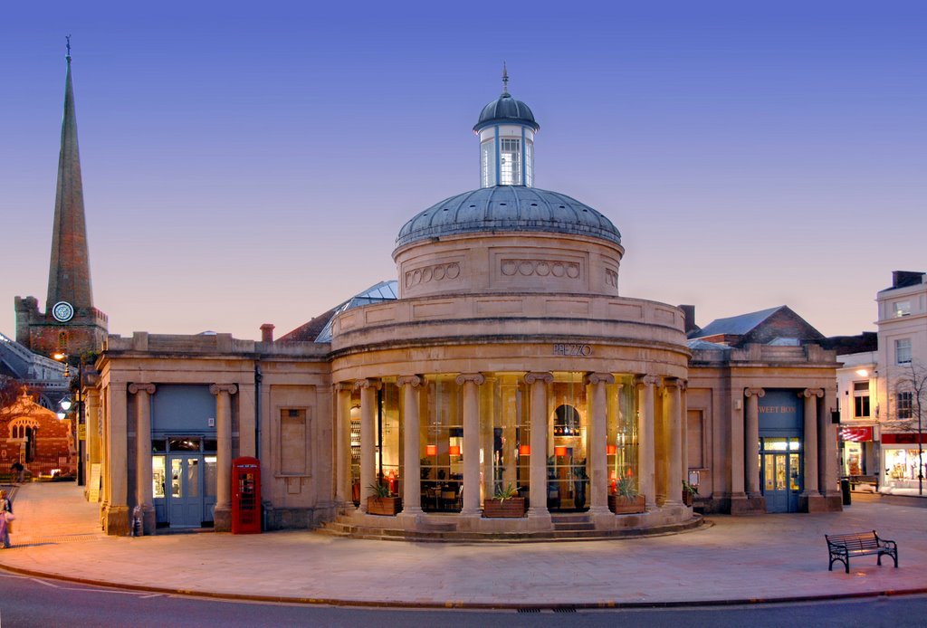
Bremerhaven (niederdeutsch Bremerhoben) ist eine kreisfreie Stadt am Westrand des Elbe-Weser-Dreiecks, das in die Nordsee übergeht. Sie liegt länglich an der Unter- und Außenweser, gegründet wurde sie 1827. Als Exklave gehört sie zum Land Freie Hansestadt Bremen. Die Großstadt ist Teil der Metropolregion Nordwest. Landseitig umschlossen ist sie vom Landkreis Cuxhaven, für den sie das Oberzentrum darstellt. Die Geschichte der Häfen in Bremerhaven beginnt 1830 mit dem Alten Hafen. Mittlerweile ist Bremerhaven nicht mehr nur eine Hafen-, Handels- und Industriestadt, sondern durch den regionalen Strukturwandel auch eine Dienstleistungs- und Wissensstadt mit Tourismus. Die Hochschule Bremerhaven und mehrere Institute und Technologiezentren bilden im Verbund mit den Bremer Wissensstandorten ein Zentrum europäischer Spitzentechnologie. Bekannt sind der Leuchtturm Bremerhaven, das Deutsche Schifffahrtsmuseum, das Deutsche Auswandererhaus und das Klimahaus Bremerhaven.
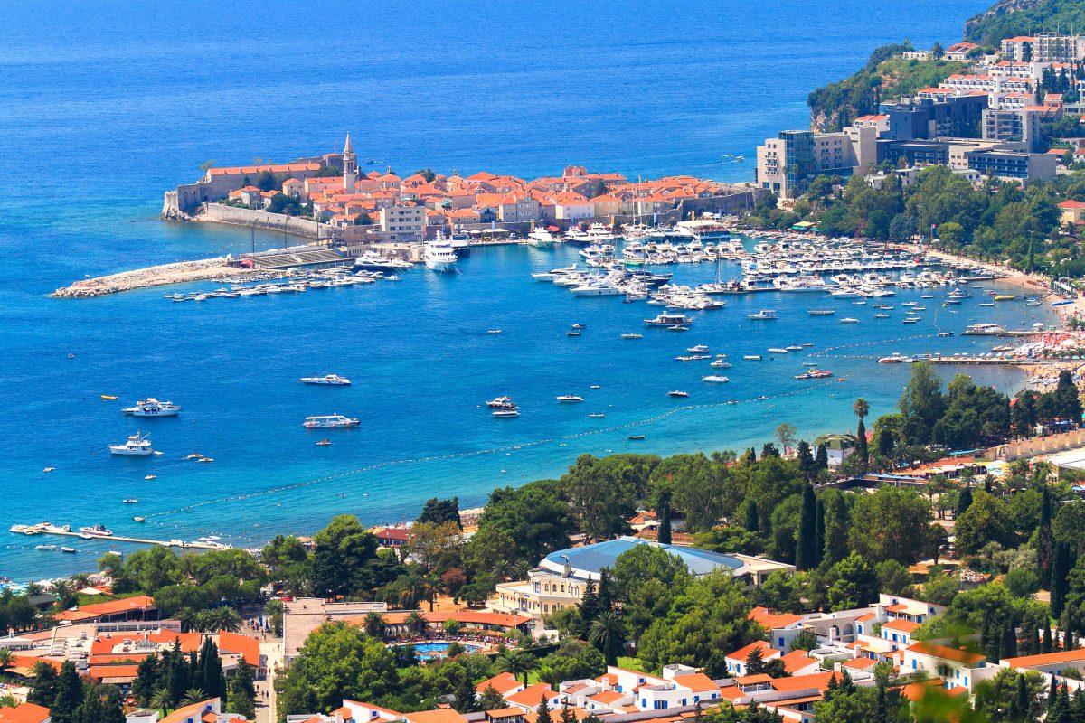
Bremerhaven bezeichnet sich als Seestadt, da der sich öffnende Mündungstrichter der Weser diesen Eindruck vermittelt.
不来梅哈芬(德语:Bremerhaven,德语发音:[bʁeːmɐˈhaːfən] (ⓘ))位于德国西北部威悉河的入海口,与不来梅组成了德国最小的联邦州不来梅州,两市之间有60公里的距离。它是位于易北河和威悉河下游之间的“易北-威悉三角地带”的中心城市,也是德国北海沿海城市中唯一一个人口超过十万的大型城市。不来梅哈芬是欧盟划定的“不来梅-奥尔登堡大都市圈”的城市之一,处在与“汉堡大都市圈”的临界线上。
依靠它的远洋港区,不来梅哈芬是德国主要的出口门户,同时跻身欧洲最大的港口城市之列。此外,它还是德国重要的科研中心,2005年被德国科学基金会协会评为“科学城”。
 Lombardia


弗罗茨瓦夫(波兰语:Wrocław;德语:Breslau,中文譯為布雷斯勞、布列斯勞、洛克勞;捷克语:Vratislav;拉丁语:Wratislavia 或 Vratislavia),是波兰城市,位于波兰西南部的奥得河畔,自1999年起是下西里西亚省的省会。该市人口约为637,075人(2016年),列波兰第四大城(次于华沙、克拉科夫和罗兹),同时也是波兰仅次于华沙的第二大金融中心,在经济、文化、交通等诸多方面都在波兰具有相当重要的地位。
弗罗茨瓦夫在其城市发展史上的大部分时期内,一直是一个以多民族、多元文化为特色的城市,德意志、波兰、捷克、犹太等民族均扮演过重要角色。而德语曾长期是占有优势地位的语言,该市的德语名称布雷斯勞(Breslau)的知名度一直很高,二战以前该市曾是德国重要的工商业与文化名城之一,城市规模居全德国第六位,那時人口已达60多万。在第二次世界大战以后的领土调整和民族大迁徙中,该市是德国在战后失去的最大城市,原有的德国居民被迫西迁,而波兰东部因為割让给苏联,大批波蘭人湧入這座城市導致弗罗茨瓦夫在人口构成上基本上成为一个纯粹的波兰城市,但由于保留下来的以及战后重建的大量普鲁士、奥地利乃至波希米亚风格的建筑,该市在波兰境内仍是一个颇为独特的城市。
Breslau (polnisch  Wrocław?/i [ˈvrɔtswaf], schlesisch Brassel,[3] lateinisch Vratislavia oder Wratislavia), im Südwesten von Polen gelegen, ist mit über 630.000 Einwohnern nach Warschau, Krakau und Łódź die viertgrößte Stadt des Landes, Verwaltungssitz des gleichnamigen Landkreises (Powiat) sowie Hauptstadt der Woiwodschaft Niederschlesien.
Als Hauptstadt der historischen Region Schlesien ist die kreisfreie Großstadt an der Oder (Odra) Sitz eines römisch-katholischen Erzbischofs und eines evangelischen Diözesanbischofs. Mit zahlreichen Unternehmen, Hochschulen, Forschungsinstituten, Theatern und Museen bildet Breslau das wirtschaftliche, kulturelle und wissenschaftliche Zentrum Niederschlesiens.
Mit ihrer wechselvollen Geschichte zwischen Deutschen und Polen, den zahlreichen historischen Bauten, Parkanlagen und Plätzen ist die Stadt heute Anziehungspunkt für Besucher aus aller Welt. Breslau war 2012 einer der Austragungsorte der Fußball-Europameisterschaft und 2016 Kulturhauptstadt Europas sowie Verleihungsort des Europäischen Filmpreises.
ヴロツワフ(ポーランド語: Wrocław[ヘルプ/ファイル]、ドイツ語: Breslau ブレスラウ、ハンガリー語: Boroszló ボロスロー)は、ポーランド西部にある第4の都市で、ドルヌィ・シロンスク県の県都。歴史的にシロンスク地方の中心都市で[1]、ポーランドの中でも最も古い都市のひとつである。市内にはオドラ川とその支流が流れ、200以上の橋が架かっている。
ヴロツワフは歴史上、様々な国(ポーランド王国、オーストリア帝国、ドイツ、ハンガリー、プロイセン、ボヘミア)の一部となっていたが、1945年(第二次世界大戦後)にポーランド領となった。
ヴロツワフは、UEFA欧州選手権2012 のホストである。2016年の欧州文化首都になることが決まっており[2]、またワールドゲームズ2017の開催地にも決定した。
Wrocław (Polish: [ˈvrɔt͡swaf] ( listen); German: Breslau [ˈbʁɛslaʊ]; Czech: Vratislav; Latin: Vratislavia) is a city in western Poland and the largest city in the historical region of Silesia. It lies on the banks of the River Oder in the Silesian Lowlands of Central Europe, roughly 350 kilometres (220 mi) from the Baltic Sea to the north and 40 kilometres (25 mi) from the Sudeten Mountains to the south. The population of Wrocław in 2017 was 638,364, making it the fourth-largest city in Poland and the main city of Wrocław agglomeration.
Wrocław is the historical capital of Silesia and Lower Silesia. Today, it is the capital of the Lower Silesian Voivodeship. The history of the city dates back over a thousand years, and its extensive heritage combines almost all religions and cultures of Europe.[2] At various times, it has been part of the Kingdom of Poland, Kingdom of Bohemia, Kingdom of Hungary, Habsburg Monarchy, Kingdom of Prussia, German Empire, Weimar Republic and Nazi Germany. Wrocław became part of Poland again in 1945, as a result of the border changes after the Second World War, which included a nearly complete exchange of population.
Wrocław is a university city with a student population of over 130,000, making it one of the most youthful cities in the country.[3] Since the beginning of the 20th century, the University of Wrocław, previously Breslau University, produced 9 Nobel Prize laureates[4] and is renowned for its high quality of teaching.[5]
Wrocław is classified as a Gamma- global city by GaWC.[6] It was placed among the top 100 cities in the world for the quality of life by the consulting company Mercer.[7]
The city hosted the Eucharistic Congress in 1997 and the Euro 2012 football championships. In 2016, the city was a European Capital of Culture and the World Book Capital. Also in this year, Wrocław hosted the Theatre Olympics, World Bridge Games and the European Film Awards. In 2017, the city was the host of the IFLA Annual Conference and the World Games.
Vratislavie1 ou localement Wrocław (prononcé [ˈvrɔt͡s.waf]Écouter ; en silésien : Brassel ; en allemand : Breslau) est la quatrième ville de Pologne par sa population (633 000 habitants), la cinquième par sa superficie (293 km2), et l'une des plus anciennement fondées (vers le IXe – Xe siècle). Aujourd’hui chef-lieu de la voïvodie de Basse-Silésie, elle est desservie par l’aéroport Nicolas Copernic de Wrocław, le cinquième plus important du pays en nombre de passagers.
Située au sud des « monts des Chats » (en polonais : Kocie Góry, et Wzgórza Trzebnickie), au nord des Sudètes, la ville est traversée par le fleuve Oder (en polonais : Odra), qui se divise ici en plusieurs bras, et quatre de ses affluents : la Bystrzyca, l’Oława, la Ślęza et la Widawa (en). Ces cours d'eau, avec les fosses municipales et les canaux d'évacuation qui s’y ajoutent, créent 12 îles et sont enjambés par plus de 120 ponts, ce qui vaut à Wrocław le surnom de « Venise polonaise » et Venise du Nord.
Vratislavie, capitale européenne de la culture 20161, après avoir été hôte de l'Euro 2012 de football, accueille les Prix du cinéma européen 2016 et Jeux mondiaux en 2017.
Breslavia (in polacco Wrocław[?·info] [ˈvrɔtswaf], in slesiano Wrocłow, in tedesco Breslau[1], in ceco Vratislav) è una città della Polonia di 640.000 abitanti, la quarta del paese per popolazione, capoluogo del voivodato della Bassa Slesia e capitale storica della Slesia. La città ha fatto parte del Regno di Prussia dal 1741 al 1918, in seguito della Repubblica di Weimar (dal 1919 al 1933) e dal 1933, della Germania nazista, che la controllerà fino al termine della seconda guerra mondiale, nel 1945.
Importante porto sul fiume Oder, sorge al centro di una ricca regione agricola. Sede di un'arcidiocesi, è il centro culturale ed economico della regione nonché polo importante nel settore della meccanica e dell'industria metallurgica. Dal 1945 al 1998 è stata capoluogo del Voivodato di Breslavia, oggi sostituito dal voivodato della Bassa Slesia. Breslavia è stata una delle città di UEFA EURO 2012. Nel 2016 è stata capitale europea della cultura e capitale mondiale del libro. Inoltre, ha ospitato i Giochi mondiali nel 2017.
Breslavia12 (en polaco, Wrocław ˈvrɔt͡swaf (?·i), en alemán: Breslau; en checo: Vratislav; en latín: Vratislavia) es una ciudad con el estatus de distrito (o distrito urbano) situada en el voivodato de Baja Silesia, en el suroeste de Polonia, junto al río Óder y entre las colinas de Trzebnica y los Sudetes. En Breslavia, confluían dos importantes rutas comerciales: Vía Regia y Ruta del ámbar. La ciudad perteneció a la Liga Hanseática. En 2006 el Centro Centenario de Breslavia fue incluido en la lista de la Unesco del Patrimonio Mundial.
La población en 2011 era de 632 996 personas3 y es la principal ciudad de la región, aglomerando a más de un millón de habitantes en su área metropolitana además de ser la capital del voivodato de Baja Silesia.
Breslavia fue la sede de la Eurocopa 2012 y del Campeonato Mundial de Voleibol Masculino de 2014. Ha sido nombrada Capital Europea de la Cultura en 2016 junto con San Sebastián y ha sido sede de los Premios del Cine Europeo 2016 y Juegos Mundiales 2017.
Вро́цлав (польск. Wrocław [ˈvrɔt͡swaf]), старое русское название — Бреславль; нем. Бре́слау (нем. Breslau, сил. Wrocłow, сил.-нем. Brassel, лат. Vratislavia, Wratislavia) — столица Силезии, город на правах повята, один из самых крупных (четвёртый по населению в Польше после Варшавы, Кракова и Лодзи) и самых старых городов Польши, расположенный на обоих берегах среднего течения Одры, на Силезской низменности. Население — 634 404 чел. (по данным 2015 года)[1].
 Bretagne

 Puglia


布里斯托尔(英语:Bristol,读音: /ˈbrɪstəl/ 帮助·信息),英国英格兰西南区域的名誉郡、单一管理区、城市。布里斯托尔西临爱尔兰海,人口410,500(英格兰第8、英国第11多),自中世纪起已是一个重要的商业港口,地位一度仅次于伦敦,直到1780年代才被利物浦、曼彻斯特、伯明翰超过。现今的布里斯托尔乃英国重要的航天、高科技及金融贸易中心,拥有一个国际机场。全市有两所大学,布里斯托尔大学和西英格兰大学。
布里斯托尔北、东、南三方都被其他的单一管理区包围:东南与萨默塞特郡的巴斯和东北萨默塞特相邻,西南与萨默塞特郡的北萨默塞特相邻,东北与格洛斯特郡的南格洛斯特郡相邻。布里斯托尔距离西面的威尔士首府加的夫约41千米(26英里),而英国首都伦敦,则位于该市东北方约131千米(81英里)的位置处。
Bristol [ˈbrɪstɫ] ist eine Stadt, eine Unitary Authority sowie eine zeremonielle Grafschaft im Südwesten von England am Fluss Avon. Bristol hatte 2019 etwa 463.000 Einwohner. Musikalisch hat die Stadt den Bristol Sound hervorgebracht.
 Medieval cities in Europe
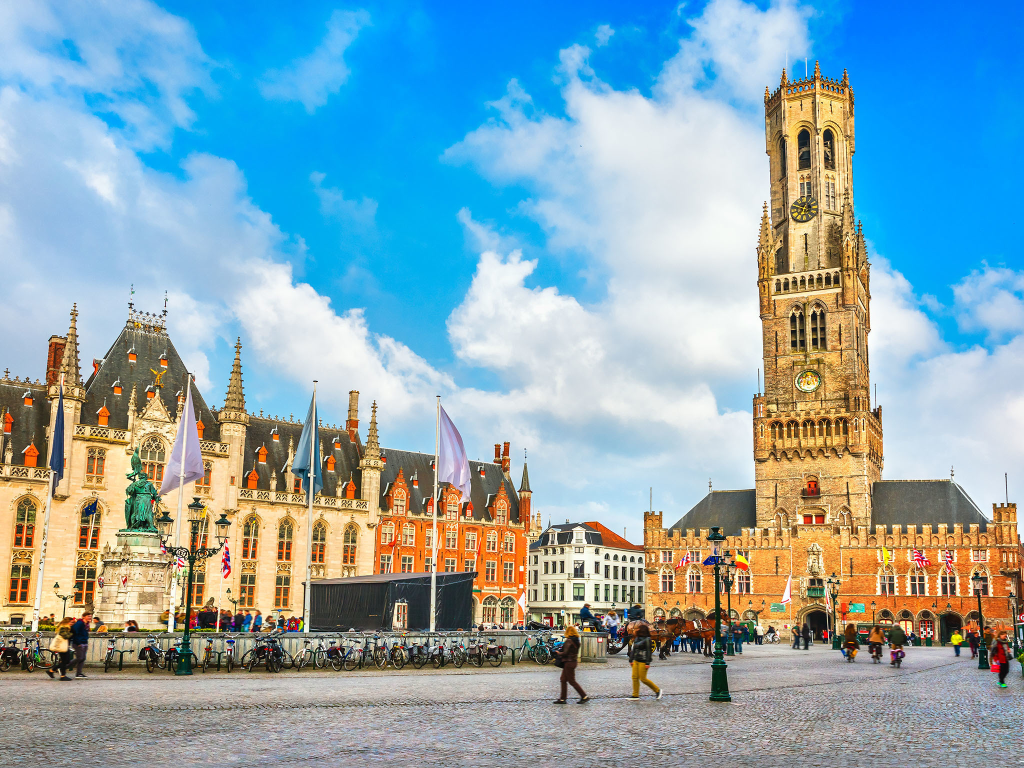
Brügge (niederländisch Brugge, französisch Bruges) ist die Hauptstadt und mit 118.284 Einwohnern (Stand 1. Januar 2018) die größte Stadt der Provinz Westflandern in Belgien. Außerdem ist Brügge Bischofssitz der katholischen Kirche für das Bistum Brügge.
Im Spätmittelalter war die niederländische Region um Brügge eines der Zentren der Textilindustrie und des Fernhandels in Europa und damit eine der Geburtsstätten des Frühkapitalismus. In der Stadt residierten zeitweise die Herzöge von Burgund, unter deren Herrschaft Brügge zu einer der wirtschaftlich und kulturell reichsten Städte im damaligen Europa wurde.
Die Altstadt ist von Wallanlagen, auf denen Windmühlen stehen, und Kanälen umgeben. Da Brügge nie durch Kriege oder großflächige Brände zerstört wurde, sind mittelalterliches Stadtbild und historische Gebäude sehr gut erhalten. Die Stadt ist sowohl zu Fuß als auch per Bootstour erkundbar. Die Kanäle, die die Stadt durchziehen, nennen die Einheimischen Reien nach dem im Mittelalter vollständig kanalisierten Flüsschen Reie, über das Brügge direkt mit der Nordsee verbunden war.
Der mittelalterliche Stadtkern wurde im Jahr 2000 von der UNESCO zum Weltkulturerbe erklärt. Im Jahr 2002 war Brügge Europäische Kulturhauptstadt.
Brügge beherbergt das renommierte Europakolleg (College of Europe) und verfügt über einen wichtigen Seehafen im Teilort Zeebrugge.
ブルッヘまたはブリュッヘ、ブルグ、ブラヘなど(フラマン語(オランダ語):Brugge[ˈbrʏʝə] 発音例)、ブリュージュ(仏語:Bruges[ˈbʁyːʒ] 発音例)、ブルージュ(英語:Bruges[ˈbruːʒ] 発音例)は、ベルギー北西部、フランデレン地域の都市で、ウェスト=フランデレン州の州都。ベルギーの代表的な観光都市の一つであり、2002年には、スペインのサラマンカとともに欧州文化首都に選定された。
日本の百科事典や地名事典では「ブルッヘ」ないし「ブリュッヘ」が用いられることが多いが、観光業などの分野では「ブルージュ」や「ブリュージュ」も多く用いられている。なお、地名の由来は「橋」であり、市内に張り巡らされた運河に架かる無数の橋に因んでいる。
Bruges (/bruːʒ/; Dutch: Brugge [ˈbrʏɣə]; French: Bruges [bʁyːʒ]; German: Brügge) is the capital and largest city of the province of West Flanders in the Flemish Region of Belgium, in the northwest of the country.
The area of the whole city amounts to more than 13,840 hectares (138.4 sq km; 53.44 sq miles), including 1,075 hectares off the coast, at Zeebrugge (from Brugge aan zee,[2] meaning "Bruges by the Sea").[3] The historic city centre is a prominent World Heritage Site of UNESCO. It is oval in shape and about 430 hectares in size. The city's total population is 117,073 (1 January 2008),[4] of whom around 20,000 live in the city centre. The metropolitan area, including the outer commuter zone, covers an area of 616 km2 (238 sq mi) and has a total of 255,844 inhabitants as of 1 January 2008.[5]
Along with a few other canal-based northern cities, such as Amsterdam, it is sometimes referred to as the Venice of the North. Bruges has a significant economic importance, thanks to its port, and was once one of the world's chief commercial cities.[6][7] Bruges is well known as the seat of the College of Europe, a university institute for European studies.[8]
Bruges (prononcé /bʁyʒ/; en néerlandais Brugge, [ˈbrʏɣə]) est une ville de Belgique située en Région flamande, chef-lieu et plus grande ville de la province de Flandre-Occidentale.
Bruges apparaît au Xe siècle en tant que place forte du comté de Flandre. En 1134, un raz-de-marée a pour conséquence bénéfique d'ouvrir un bras de mer, le Zwin, donnant un accès direct à la mer pour la ville, ce qui entraîne un développement urbain spectaculaire entre le XIIe et le XVe siècle, avec le creusement de nombreux canaux. Forte de son indépendance communale symbolisée par son beffroi, Bruges devient une plaque tournante portuaire, commerciale et financière centrale dans l'Europe du Moyen Âge, reliant les pays de la mer du Nord et de la Baltique à la Méditerranée. Les riches marchands brugeois traitaient avec ceux de toute l'Europe. La première bourse de valeurs de l'histoire est née à Bruges au XIIIe siècle. Au XVe siècle elle est la première place financière d'Europe. Cet essor économique entraîne également une floraison culturelle et artistique. Elle a été le centre le plus important pour les peintres primitifs flamands, qui ont révolutionné la peinture occidentale, et dont les œuvres sont aujourd'hui dispersées dans les grands musées du monde entier. Mais le Zwin s'ensabla peu à peu aux XVe et XVIe siècles, éloignant progressivement la ville de son accès à la mer, ce qui provoqua un déclin économique irrémédiable au profit de sa voisine, Anvers. Bruges est alors tombée au rang de simple ville provinciale.
Ce n'est qu'au XXe siècle que la ville connaît un nouveau développement grâce à la création du vaste port de Bruges-Zeebruges, qui fait aujourd'hui partie intégrante du Range nord-européen. La longue période de torpeur qu'a connu la ville après la Renaissance a permis à l'essentiel de son tissu urbain médiéval et à une bonne partie de ses monuments anciens de rester préservés. La « belle endormie » est alors apparue aux XIXe et XXe siècles comme l'un des joyaux du patrimoine européen. Ce patrimoine ancien a été méticuleusement restauré et mis en valeur. Une architecture néogothique de qualité s'est aussi développée parallèlement, faisant véritablement renaître le style local et redonnant au centre historique un aspect médiéval plus complet. Comme d'autres villes, elle est parfois surnommée la « Venise du Nord » du fait de ses canaux qui encerclent ou traversent la vieille ville dans un cadre pittoresque. Bruges est ainsi devenue la ville la plus touristique de Belgique. Elle héberge aussi le Collège d'Europe.
Elle est membre de l'Organisation des villes du patrimoine mondial depuis l'an 2000. La ville a même la particularité de figurer trois fois sur la liste du Patrimoine mondial de l'UNESCO. Pour son centre historique, pour son béguinage faisant partie des béguinages flamands et pour son beffroi comptant parmi les beffrois de Belgique et de France. En outre, elle est aussi reprise comme Patrimoine culturel immatériel de l'humanité de l'UNESCO pour sa procession du Saint-Sang. Elle fut également la capitale européenne de la culture en 2002, en même temps que la ville espagnole de Salamanque.
Bruges[1][2] (in francese, pron. /bʀyʒ/) o Brugge (in nederlandese, pron. /'brʏɣə/; nella variante fiamminga pronunciato /'brʏʝə/; Brügge in tedesco), in italiano in passato Bruggia[3], è una città del Belgio, capoluogo e maggiore città delle Fiandre Occidentali, nella Comunità fiamminga.
Sede permanente del Collegio d'Europa e di una diocesi cattolica, il centro storico medievale è stato proclamato nel 2000 patrimonio dell'umanità dall'UNESCO. Nel 2002 la città è stata capitale europea della cultura insieme alla città spagnola di Salamanca.
Brujas (en neerlandés Brugge [ˈbrʏɣə]; en francés, Bruges [bʁyːʒ]; en alemán Brügge ['bʁygə]) es una ciudad belga. Es la capital de la provincia de Flandes Occidental. Situada en el extremo noroeste de Bélgica a 90 kilómetros de la capital Bruselas, cuenta en su núcleo urbano con una población de 117.000 habitantes.
Su nombre proviene del germánico occidental "Bryggia" ("puentes", "muelles", "atracaderos"). Es interesante destacar que, en el neerlandés, «brug» significa «puente», y que esta ciudad ostenta como nombre el plural de esta palabra, debido a la gran cantidad de puentes que en ella existen.
El mayor atractivo de Brujas es su casco histórico, declarado Patrimonio de la Humanidad por la Unesco en el 2000.1 Aunque en gran parte ha sido reconstruido, dicho centro urbano es uno de los más grandes atractivos europeos, ya que mantiene intactas las estructuras arquitectónicas medievales. Al igual que Ámsterdam, Gotemburgo y Hamburgo, entre otras, Brujas es conocida como «la Venecia del norte», debido a la gran cantidad de canales que atraviesan la ciudad y a la belleza de los mismos.
Брю́гге (нидерл. Brugge [ˈbrʏʝə], фр. Bruges, нем. Brügge) — город в Бельгии, центр провинции Западная Фландрия. Один из самых живописных городов Европы [источник не указан 1036 дней]. Население — 117 172 человек (2013). Экономический и культурный расцвет Брюгге связывают с эпохой высокого и позднего Средневековья (XII—XV вв.).
 Belgium
Eurovision Song Contest,ESC
UEFA European Championship 2020
Belgium
Eurovision Song Contest,ESC
UEFA European Championship 2020
 History
 International cities
 *European Capital of Culture
 World Heritage
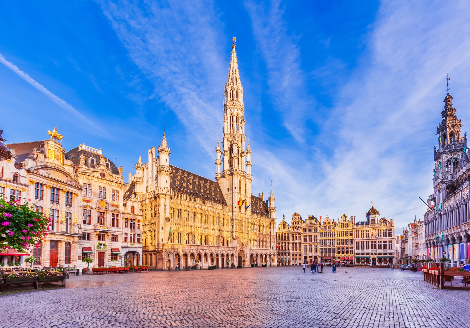

布鲁塞尔(法语:Bruxelles;荷兰语:Brussel)是比利时的首都和最大的城市,也是欧洲联盟的主要行政机构所在地。位于布鲁塞尔首都区的布鲁塞尔市,[1]。 在不同的语境中,布鲁塞尔有着不同的外延。她可能代表布鲁塞尔市(比利时的布鲁塞尔首都区中最大的地方自治体及首府,常住人口140,000),也可能代表布鲁塞尔首都区(据2008年2月1日统计,常住人口为1,067,162),或者也可能用于表示布鲁塞尔城市圈(常住人口1,350,000[2])。
欧洲联盟三个主要的机构当中,欧盟委员会和欧盟部长理事会位于布鲁塞尔,另一个重要机构欧洲议会在布鲁塞尔也有分处(全体议会在法国斯特拉斯堡),所以它有欧洲首都的美誉。另外,北大西洋公约组织的总部也设在布鲁塞尔。
布鲁塞尔是一个双语城市,通用法语和荷兰语,法语的使用者占较多数。另外,土耳其语、阿拉伯语等语言被布鲁塞尔的穆斯林广泛使用。
Mit Brüssel (französisch Bruxelles [bryˈsɛl], niederländisch Brussel [brɵsəɫ]) kann entweder eine Stadt in Belgien gemeint sein oder die größere Hauptstadtregion mit 19 Gemeinden beziehungsweise das gesamte städtische Gebiet der Hauptstadtregion.
Die zweisprachige Region Brüssel-Hauptstadt (französisch Région de Bruxelles-Capitale, niederländisch Brussels Hoofdstedelijk Gewest) ist neben Flandern und der Wallonischen Region eine von drei Regionen im föderalen belgischen Staatsaufbau. Die Region hat über eine Million Einwohner und besitzt eine höhere Bevölkerungsdichte als irgendeine deutsche Großstadt.[1] Sie ist daher nicht mit den weit ins Umland reichenden Metropolregionen vergleichbar, die in den letzten Jahren rund um viele europäische, unter anderem auch deutsche Großstädte definiert wurden. Der Ballungsraum Brüssel ist noch einmal wesentlich größer als die Region Brüssel.
Die Stadt Brüssel ist die Haupt- und Residenzstadt des Königreichs Belgien. Sie bildet das Zentrum der Region Brüssel-Hauptstadt, ist eine ihrer 19 Gemeinden und hat etwa 180.000 Einwohner. Dort haben mehrere föderale Institutionen ihren Sitz: Die Stadt Brüssel ist Verwaltungssitz der Region Brüssel-Hauptstadt. Hier befindet sich darüber hinaus der Verwaltungssitz der Französischen Gemeinschaft Belgiens, während die Wallonische Region ihren Sitz in Namur hat. Die Organe der Region Flandern und der Flämischen (niederländischsprachigen) Gemeinschaft sind fusioniert und haben ihren Sitz ebenfalls in der Stadt Brüssel. Zudem stellt die Stadt den Hauptsitz der Europäischen Union sowie den Sitz der NATO, ferner den des ständigen Sekretariats der Benelux-Länder und von EUROCONTROL dar.
Im Jahre 996 erstmals urkundlich erwähnt und im Mittelalter zur Hauptstadt des Herzogtums Brabant aufgestiegen, wurde Brüssel mit der Unabhängigkeit Belgiens 1830 zu dessen Hauptstadt erhoben. Zusammen mit seinen umliegenden Gemeinden ist Brüssel heute als Industrie- und Handelsstadt mit zwei Universitäten, mehreren Hochschulen, Akademien, Bibliotheken, Museen und Bühnen ein bedeutendes Wirtschafts-, Wissenschafts- und Kulturzentrum sowie ein wichtiger Verkehrsknotenpunkt im Zentrum des Landes.
Der Artikel Region Brüssel-Hauptstadt behandelt vor allem die Themen Politik, Verwaltung und Sprachensituation. Weitere und übergreifende Themen werden nachfolgend behandelt.
ブリュッセル市(ブリュッセルし、フランス語: Ville de Bruxelles [ˈvil də bʀyˈsɛl] または Bruxelles-Ville、オランダ語: Stad Brussel [s̪t̪ɑt̪ ˈbrʏ.s̪əl̪] または Brussel-Stad)は、ブリュッセル首都圏地域を構成する最大の基礎自治体である。ベルギーの憲法上の首都である[2]が、実際にはブリュッセル首都圏地域全体で首都としての機能を果たしている。主としてブリュッセルの歴史的中心部から成り、ロンドンにおけるシティにたとえることができる。
ブリュッセル市は、ブリュッセルの歴史的な中心市街地に加えて、ブリュッセル首都圏地域内のいくつかの地区、すなわち北部のアレン、ラーケンおよびネデル=オヴェル=エンベーク、ならびに南部のルイーズ大通りおよびカンブルの森から構成される。
ブリュッセル市の総面積は32.61 km2、2014年9月1日現在の総人口は173,540人で、人口密度は5,321.68人/km2である[1]。また2014年時点で、ブリュッセル市の人口約17万人のうち、約6万人が外国人(うち3万6千人がEU市民、2万4千人が非EU市民)となっている[3]。
The City of Brussels (French: Ville de Bruxelles [vil də bʁysɛl] or alternatively Bruxelles-Ville [bʁysɛl vil], Dutch: Stad Brussel [stɑd ˈbrɵsəl][2] or Brussel-Stad) is the largest municipality and historical centre of the Brussels-Capital Region, and the de jure capital of Belgium.[3] Besides the strict centre, it also covers the immediate northern outskirts where it borders municipalities in Flanders. It is the administrative centre of the European Union, thus often dubbed, along with the region, the EU's capital city.
The City of Brussels is a municipality consisting of the central historic town and certain additional areas within the greater Brussels-Capital Region, namely Haren, Laeken and Neder-Over-Heembeek to the north, and Avenue Louise/Louizalaan and the Bois de la Cambre/Ter Kamerenbos park to the south.
On 1 January 2017, the City of Brussels had a total population of 176,545. The total area is 32.61 km2 (12.59 sq mi) which gives a population density of 5,475 inhabitants per square kilometre (14,180/sq mi). As of 2007, there were approximately 50,000 registered non-Belgians in the City of Brussels.[4] In common with all the Brussels municipalities, it is legally bilingual (French–Dutch).
Bruxelles (prononcé [bʁy.sɛl]1 Écouter ; Brussel [ˈbrʏ.səl] Écouter en néerlandais ; Brüssel en allemand ; parfois aussi appelé aire urbaine de Bruxelles, Stedelijk gebied van Brussel en néerlandais, ou Grand Bruxelles2) est une agglomération de Belgique qui s'étend au-delà des limites administratives de la Région de Bruxelles-Capitale pour englober des parties du Brabant wallon et l'arrondissement de Hal-Vilvorde, et au centre de laquelle se trouve la ville de Bruxelles proprement dite.
La plupart des institutions de l’Union européenne, ainsi que de nombreuses organisations internationales entre autres lobbyistes, dont l’OTAN, ont leur siège en Région de Bruxelles-Capitale. Par extension, on dit donc « Bruxelles » pour désigner, en général et par métonymie, les institutions européennes (le plus souvent, la Commission européenne).
L'initiative Brussels Metropolitan, lancée en 2008, vise à mieux coordonner la ville et son arrière-pays pour valoriser le Grand Bruxelles en tant que métropole économique attrayante au cœur de l'Europe3, lui donner plus de poids sur le plan mondial et y stimuler la croissance et la création d'emplois4. Cette plateforme de coopération implique la participation de quatre organisations patronales - la FEB, BECI, le Voka et l'UWE4.
Bruxelles (nome francese; pronuncia /bʀy'sɛl/ o, meno correttamente, /bʀyk'sɛl/, italianizzata in /brukˈsɛl/[1]; in olandese Brussel, in tedesco Brüssel; in italiano storico Brusselle[2] o Borsella[3]) è un'area metropolitana del Belgio che ospita all'incirca 2,6 milioni di abitanti.[4]
Il comune di Bruxelles è uno dei 19 comuni della regione amministrativa di "Bruxelles-capitale", con cui non dovrebbe essere confuso. Questa regione è una delle tre regioni amministrative del Belgio, con la Regione vallone e la Regione fiamminga. L'area metropolitana di Bruxelles si estende oltre i confini amministrativi della Regione di Bruxelles in quanto comprende molti comuni situati nella regione fiamminga. Questa situazione è all'origine del conflitto linguistico in Belgio poiché molti residenti di Bruxelles, per lo più francofoni, sono stabiliti nella regione fiamminga di lingua olandese.
Bruxelles è considerata la capitale de facto dell'Unione europea in quanto sede di varie istituzioni, tra cui la Commissione europea, il Consiglio dell'Unione europea e parzialmente il Parlamento europeo (ufficialmente con sede a Strasburgo). Ad Evere ha inoltre sede il quartier generale della NATO. Bruxelles ospita anche il Comitato delle Regioni e il Comitato economico e sociale.
Gran parte dell'area metropolitana di Bruxelles è amministrata dalla regione di Bruxelles-Capitale, suddivisa in 19 comuni, tra cui quello del centro storico, il Comune di Bruxelles (Ville de Bruxelles/Brussel-stad). La città si estende però anche al di là dei confini della regione: vari comuni della periferia brussellese, amministrativamente parte della regione delle Fiandre, sono parte integrante del tessuto urbano di Bruxelles.[5] Tra questi Zaventem (sede dell'aeroporto internazionale), Kraainem (capolinea della metropolitana) e Tervuren (quartiere residenziale).
Bruselas (en francés: Bruxelles ![]() [bʁysɛl] (?·i), en neerlandés: Brussel
[bʁysɛl] (?·i), en neerlandés: Brussel ![]() [ˈbrɵsəl] (?·i) y en alemán: Brüssel) es la capital de Bélgica,1 y la principal sede administrativa de la Unión Europea (UE).
[ˈbrɵsəl] (?·i) y en alemán: Brüssel) es la capital de Bélgica,1 y la principal sede administrativa de la Unión Europea (UE).
Bruselas es un municipio situado en la región administrativa "Bruselas-Capital" que es una de las tres regiones de Bélgica, con la Región Valona y la Región flamenca.
Como capital del Estado, Bruselas es la sede del gobierno y el Parlamento. Alberga también, el Castillo de Laeken la residencia de Su Majestad el rey Felipe de Bélgica y la familia real belga.
Брюссе́льский столи́чный регио́н (фр. Région de Bruxelles-Capitale, ʁe'ʒjɔ̃ də bʁy'sɛlkapi'tal ![]() слушать, нидерл. Brussels Hoofdstedelijk Gewest, ˈbrʏsəɫs ɦoːft'steːdələk xəʋɛst
слушать, нидерл. Brussels Hoofdstedelijk Gewest, ˈbrʏsəɫs ɦoːft'steːdələk xəʋɛst ![]() слушать, а также просто фр. Bruxelles, bʁysɛl
слушать, а также просто фр. Bruxelles, bʁysɛl ![]() слушать; нидерл. Brussel, ˈbrʏsəɫ
слушать; нидерл. Brussel, ˈbrʏsəɫ ![]() слушать) — один из трёх регионов Бельгии, субъект федерации наравне с Фламандским и Валлонским регионами. Крупнейшая городская зона-агломерация в Бельгии[1], состоящая из 19 муниципалитетов, каждый со своим бургомистром, ратушей и т. д. Фактически они являются районами одного города (часто граница проходит посередине улицы). Формально название Брюссель относится только к одному из вышеуказанных муниципалитетов, но на практике его употребляют ко всей агломерации. Одним из муниципалитетов является Брюссель, который де-юре является столицей Бельгии, и в котором находятся Французское и Фламандское сообщества[2]. Де-факто, в силу того что столичные учреждения распределены по различным муниципалитететам Брюссельского столичного региона, регион считается столицей Бельгии, столицей Европейского союза[3].
слушать) — один из трёх регионов Бельгии, субъект федерации наравне с Фламандским и Валлонским регионами. Крупнейшая городская зона-агломерация в Бельгии[1], состоящая из 19 муниципалитетов, каждый со своим бургомистром, ратушей и т. д. Фактически они являются районами одного города (часто граница проходит посередине улицы). Формально название Брюссель относится только к одному из вышеуказанных муниципалитетов, но на практике его употребляют ко всей агломерации. Одним из муниципалитетов является Брюссель, который де-юре является столицей Бельгии, и в котором находятся Французское и Фламандское сообщества[2]. Де-факто, в силу того что столичные учреждения распределены по различным муниципалитететам Брюссельского столичного региона, регион считается столицей Бельгии, столицей Европейского союза[3].
Брюссель начинался как город-крепость в 10 веке, основанный Карлом I[4]. Население региона составляет 1,1 миллион человек, а всё население метрополии — более 1,8 миллионов, занимая таким образом первое место по этому показателю в Бельгии[5][6]. Со времён окончания Второй мировой войны Брюссель является одним из главных центров мировой политики. Будучи местом расположения институтов Европейского союза[7] и штаб-квартиры НАТО, Брюссель стал многоязыковым домом для многочисленных международных организаций, политиков и дипломатов[8].
Исторически нидерландоязычный, Брюссель со времён обретения Бельгией независимости в 1830 году, превратился почти полностью во франкоязычный регион. На сегодняшний день официальными считаются оба языка. Все дорожные знаки, названия улиц и большая часть рекламы и названий услуг приводятся на двух языках[9]. Языковой вопрос остаётся острым в Брюсселе, законы, затрагивающие его, являются предметом неутихающих обсуждений в Бельгии.
UEFA European Championship 2020
History
ITU World Championship Series
Silk road
 Sport
Triathlon
Hungary
Sport
Triathlon
Hungary
 Cities founded by the Romans
World Heritage
Cities founded by the Romans
World Heritage


ブダペストまたはブダペシュト(ハンガリー語: Budapest, 英語:[ˈbuːdəpɛst], [ˈbuːdəpɛʃt] or [ˈbʊdəpɛst]; ハンガリー語発音: [ˈbudɒpɛʃt] (![]() 音声ファイル))は、ハンガリーの首都であり、同国最大の都市である[2]。
音声ファイル))は、ハンガリーの首都であり、同国最大の都市である[2]。
「ブダペスト」として一つの市でドナウ川の両岸を占めるようになったのは1873年11月17日に西岸のブダとオーブダ、東岸のペストが合併してからである[3][4]。
ドナウ川河畔に位置し、ハンガリーの政治、文化、商業、産業、交通の一大中心都市で[5]、東・中央ヨーロッパ (en) では最大、欧州連合の市域人口では8番目に大きな都市である。しばしばハンガリーのプライメイトシティとも表現される[6]。
ブダペストの市域面積は525km2 (202.7 sq mi)[3]で、2011年の国勢調査によるブダペストの人口は174万人[7]、ピークであった1989年の210万人より減少している[8]。これは、ブダペスト周辺部の郊外化によるものである[9]。ブダペスト都市圏(通勤圏)の人口は330万人である[10][11]。
ブダペストの歴史の始まりはローマ帝国のアクインクムとしてで、もともとはケルト人の集落であった[12][13]。アクインクムは古代ローマの低パンノニア属州の首府となっている[12]。マジャル人がブダペスト周辺にやって来たのは[14]9世紀頃である。最初の集落は1241年から1242年にかけてモンゴルの襲来 (en) により略奪された[15]。15世紀に[16]町が再建されるとブダペストはルネサンス期の人文主義者文化の中心となった[17]。続いてモハーチの戦いが起こり、オスマン帝国による150年間の支配が続き[18]、18世紀、19世紀に新しい時代に入ると町は発展し繁栄する。ブダペストは1873年にドナウ川を挟んだ都市の合併が行われると、世界都市となる[19]。また、1848年から1918年の第一次世界大戦勃発まで列強に含まれたオーストリア=ハンガリー帝国のウィーンに続く第二の首都であった。1920年のトリアノン条約によりハンガリーは国土の72%を失い、ハンガリーの文化や経済をブダペストがすべてを占めるようになった。ブダペストはその大きさや人口で圧倒的に優位に立ち、ハンガリーの他の都市を小さく見せていた[20]。ブダペストはハンガリー革命 (1848年)や1919年のハンガリー評議会共和国、1944年のパンツァーファウスト作戦、1945年のブダペスト包囲戦、1956年のハンガリー動乱など数々の歴史的な舞台の場でもあった。
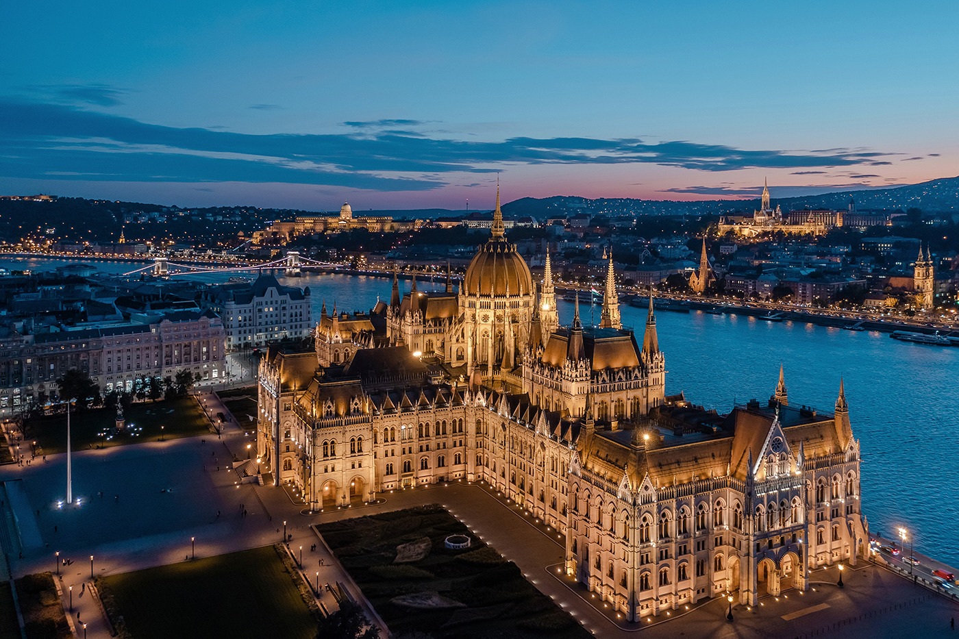
ブダペストはヨーロッパでも最も美しい街の一つで[2][21][22]、ドナウ川河岸を含め世界遺産が広がりブダ城やアンドラーシ通り、英雄広場は良く知られている。ブダペスト地下鉄1号線Millenniumi Földalatti Vasútはロンドン地下鉄に次いで世界で2番目に古い地下鉄である[21][23]。ブダペストの他のハイライトはセーチェーニ温泉を含めた80の温泉で[24]世界でも最大の地下熱水系統がある[25]。世界で3番目に大きなシナゴーグであるドハーニ街シナゴーグや国会議事堂などもブダペストの見所である。ブダペストの観光客数は年間270万人に上り、ロンドンにある民間調査機関ユーロモニターによればブダペストは世界で37番目に旅行者が多い観光地であるとされている[26]。
Budapest /ˈbuːdəpɛst/ is the capital and the most populous city of Hungary, and the tenth-largest city in the European Union by population within city limits.[9][10][11] The city had an estimated population of 1,752,704 in 2016 distributed over a land area of about 525 square kilometres (203 square miles).[12] Budapest is both a city and county, and forms the centre of the Budapest metropolitan area, which has an area of 7,626 square kilometres (2,944 square miles) and a population of 3,303,786, comprising 33 percent of the population of Hungary.[13][14]
The history of the city began when an early Celtic settlement transformed into a Roman town of Aquincum,[15][16] the capital of Lower Pannonia.[15] The Hungarians arrived in the territory in the late 9th century.[17] By the 11th century, Buda and Óbuda (Old Buda) became the names of their settlements on the west bank of the river Danube, with a formerly Slavic and then German settlement Pest on the opposite side.[3][18] The area was pillaged by the Mongols in 1241.[18] The Battle of Mohács in 1526 was followed by nearly 150 years of Ottoman rule.[19] After the reconquest of Buda in 1686, the region entered a new age of prosperity. Pest-Buda became a global city with the unification of Buda, Óbuda, and Pest on November 17, 1873, with the name 'Budapest' given to the new capital.[12][20] Budapest also became the co-capital of the Austro-Hungarian Empire,[21] a great power that dissolved in 1918, following World War I. The city was the focal point of the Hungarian Revolution of 1848, the Battle of Budapest in 1945, and the Hungarian Revolution of 1956.[22][23]
Budapest is a Beta+ global city with strengths in commerce, finance, media, art, fashion, research, technology, education, and entertainment.[24][25] It is Hungary's financial centre[26] and the highest ranked Central and Eastern European city on Innovation Cities Top 100 index,[27][28][29] as well ranked as the second fastest-developing urban economy in Europe.[30] Budapest is host to many major international organization's regional offices, including the United Nations and ICDT,[31] furthermore it is the headquarters of the European Institute of Innovation and Technology,[32] the European Police College[33] and the first foreign office of the China Investment Promotion Agency.[34] Over 40 colleges and universities are located in Budapest, including the Eötvös Loránd University, Semmelweis University and the notable Budapest University of Technology and Economics.[35][36] Opened in 1896,[37] the city's subway system, the Budapest Metro, serves 1.27 million, while the Budapest Tram Network serves 1.08 million passengers daily.[38]
Budapest is cited as one of the most beautiful cities in Europe,[9][39][40] ranked as "the world's second best city" by Condé Nast Traveler,[41] and "Europe's 7th most idyllic place to live" by Forbes.[42] Among Budapest's important museums and cultural institutions is the Museum of Fine Arts. Further famous cultural institutions are the Hungarian National Museum, House of Terror, Franz Liszt Academy of Music, Hungarian State Opera House and National Széchényi Library. The central area of the city along the Danube River is classified as a UNESCO World Heritage Site and has many notable monuments, including the Hungarian Parliament, Buda Castle, Fisherman's Bastion, Gresham Palace, Széchenyi Chain Bridge, Matthias Church and the Liberty Statue.[43] Other famous landmarks include Andrássy Avenue, St. Stephen's Basilica, Heroes' Square, the Great Market Hall, the Nyugati Railway Station built by the Eiffel Company of Paris in 1877 and the second-oldest metro line in the world, the Millennium Underground Railway.[39] The city also has around 80 geothermal springs,[44] the largest thermal water cave system,[45] second largest synagogue, and third largest Parliament building in the world.[46] Budapest attracts 4.4 million international tourists per year, making it a popular destination in Europe.[47]
Budapest (prononcé [by.da.ˈpɛst] , hongrois : Budapest [ˈbu.dɒ.pɛʃt] Écouter ; allemand : Budapest ou anciennement Ofen-Pesth) est la plus grande ville et la capitale de la Hongrie. Elle se situe en aval du coude du Danube entre le massif de Transdanubie et l'Alföld. Ses habitants sont les Budapestois (en hongrois, budapesti, -ek).
La ville actuelle est créée en 1873 par la fusion de Buda — alors capitale de la Hongrie — de Pest et d'Óbuda1. Elle a pour origine le site d'Aquincum2, un point de peuplement celte3 devenu capitale de la Pannonie inférieure pendant l'époque romaine3. Les Magyars arrivent dans la région au IXe siècle. Leur premier point d'implantation est pillé par les Mongols en 1241-12424. La ville est reconstruite et devient l'un des centres de la culture humaniste de la Renaissance5 au XVe siècle6. Après près de 150 ans de domination ottomane, elle poursuit son développement et connaît son apogée avec l'épanouissement de l'ère industrielle aux XVIIIe et XIXe siècles. Après la fusion de 1873 et l'accession de la ville au rang de seconde capitale de l'Autriche-Hongrie, Budapest atteint les proportions et les caractéristiques d'une ville mondiale7. Marquée par les différentes traces léguées par l'histoire, Budapest a notamment été l'épicentre de la révolution hongroise de 1848, de la République des conseils de Hongrie de 1919, de l'opération Panzerfaust en 1944, de la bataille de Budapest de 1945 et de l'insurrection de 1956.
Considérée comme l'une des plus belles villes d'Europe et comme la « perle » du Danube8,1,9, son panorama, le quartier du château de Buda, l'avenue Andrássy et le métropolitain du Millénaire figurent au patrimoine mondial de l'UNESCO8,10. Destination touristique importante, la ville attire plus de 4,3 millions de visiteurs par an11.
Plus grande ville du pays, elle en est le principal centre politique, culturel, commercial et industriel. Elle abrite le Parlement hongrois, les bâtiments ministériels et les ambassades du pays ainsi que les sièges sociaux des entreprises installées en Hongrie. Son ancien statut de cocapitale de l'Autriche-Hongrie lui confère un rayonnement important dans la Mitteleuropa. La partition du royaume de Hongrie à la suite du traité de Trianon en 1920 en fait une ville démesurée pour la Hongrie dans ses frontières actuelles. La macrocéphalie dont est atteinte la ville se concrétise par la convergence de la plupart des réseaux routiers et ferroviaires du pays en son centre et des écarts démographiques et économiques disproportionnés entre la capitale et la province12 (près de 20 % de la population hongroise est budapestoise). Avec ses 1 702 297 habitants13 (l'aire urbaine en compte 2 524 697), Budapest est également la ville la plus peuplée d'Europe centrale (si l'on exclut Berlin de l'Europe centrale). Elle en est également considérée du point de vue des échanges économiques comme une importante plaque tournante14. Budapest abrite le siège de l'Institut européen d'innovation et de technologie (IET)15.
Budapest (IPA: [ˈbudɒpɛʃt]; pronuncia italiana moderna: /ˈbudapest/[1]) è la capitale e la maggiore città dell'Ungheria.
Amministrata come un comune autonomo, costituisce inoltre il centro primario del Paese per la vita politica, economica e culturale; al 2016 conta 1 759 407 abitanti, mentre la popolazione residente nell'area metropolitana ammonta a oltre 3 300 000 persone.
Budapest nacque ufficialmente nel 1873 dall'unione delle città storiche di Buda e Óbuda, ubicate sulla sponda destra del Danubio, con l'abitato di Pest, situato sulla riva opposta del fiume e anch'esso di antiche origini; fino al 1918 fu una delle due capitali dell'Impero austro-ungarico, dissoltosi al termine della prima guerra mondiale.
Nel XXI secolo, Budapest è diventata una metropoli globale e si è affermata come una popolare destinazione turistica: nel 2011, secondo i dati forniti da Euromonitor International, la capitale ungherese è stata la 25ª città più visitata del mondo[2].
Budapest (![]() /ˈbudɒpɛʃt/ (?·i)) es la capital y ciudad más poblada de Hungría,2 así como su principal centro industrial, comercial y de transportes.3 La ciudad posee 1,74 millones de habitantes (2011),4 una disminución significativa respecto de los casi 2,1 millones con que contaba a mediados de los años 1980,5 que representan un quinto de la población total de Hungría. Es la ciudad más poblada de Europa central-oriental y la séptima de la Unión Europea. La ciudad ocupa una superficie de 525 km²6 y su área metropolitana cuenta con una población de 2,38 millones de habitantes. Budapest se convirtió en una única ciudad cuando ocupó las dos orillas del río Danubio, unificando las ciudades de Buda y Óbuda, en la orilla oeste, con Pest, en la orilla este, el 17 de noviembre de 1873.67
/ˈbudɒpɛʃt/ (?·i)) es la capital y ciudad más poblada de Hungría,2 así como su principal centro industrial, comercial y de transportes.3 La ciudad posee 1,74 millones de habitantes (2011),4 una disminución significativa respecto de los casi 2,1 millones con que contaba a mediados de los años 1980,5 que representan un quinto de la población total de Hungría. Es la ciudad más poblada de Europa central-oriental y la séptima de la Unión Europea. La ciudad ocupa una superficie de 525 km²6 y su área metropolitana cuenta con una población de 2,38 millones de habitantes. Budapest se convirtió en una única ciudad cuando ocupó las dos orillas del río Danubio, unificando las ciudades de Buda y Óbuda, en la orilla oeste, con Pest, en la orilla este, el 17 de noviembre de 1873.67
La historia de Budapest comenzó con Aquincum, originalmente un asentamiento celta89 que se convirtió en la capital romana de Panonia Inferior.8 Los húngaros llegaron al territorio en el siglo IX.10 Su primer asentamiento fue saqueado por los mongoles en 1241-42.11 La ciudad restablecida se convirtió en uno de los centros de la cultura del Renacimiento humanista en el siglo XV.1213 Después de la batalla de Mohács y tras casi 150 años de dominio otomano,14 el desarrollo de la región entró en una nueva era de prosperidad en los siglos XVIII y XIX, y Budapest se convirtió en una ciudad global después de la unificación de 1873.15 También se convirtió en la segunda capital de Austria-Hungría, una gran potencia que se disolvió en 1918. Budapest fue el punto focal de la revolución húngara de 1848, la República Soviética Húngara de 1919, la Operación Panzerfaust en 1944, la batalla de Budapest de 1945 y la Revolución de 1956.
Considerada como una de las ciudades más bellas de Europa,21617 Budapest cuenta con varios sitios que son Patrimonio de la Humanidad, entre los que se incluyen, a orillas del Danubio, el barrio del Castillo de Buda, la avenida Andrássy, la Plaza de los Héroes y el Metropolitano del Milenio, el segundo más antiguo del mundo.1618 Otros puntos destacados incluyen un total de 80 manantiales geotérmicos,19 el mayor sistema de cuevas de aguas termales del mundo,20 la segunda sinagoga más grande y el tercer edificio del Parlamento más grande del mundo. La ciudad atrae a alrededor de 4,3 millones de turistas al año, convirtiéndola en la 25.ª ciudad más popular del mundo, según Euromonitor.21
Budapest es, también, un importante centro financiero de Europa Central. La ciudad se situó tercera (de un total de 65 ciudades) en el Índice de Mercados Emergentes elaborado por Mastercard,22 y clasificada como la ciudad mejor habitable de Europa Central y Europa del Este por índice de calidad de vida según Economist Intelligence Unit.2324 También se clasificó como el "séptimo lugar idílico de Europa para vivir" por la revista Forbes,25 y como la novena ciudad más bella del mundo por UCityGuides.26 Es, también, la mejor ciudad de Europa Central y del Este en el índice Innovation Cities' Top 100.2728
Будапе́шт (венг. Budapest [ˈbudɒpɛʃt]) — столица Венгрии и самый крупный город страны. По численности населения, составлявшей на январь 2014 года 1,745 млн жителей[2], в Европейском союзе Будапешт занимает восьмое место. Город образовался в 1873 году в результате слияния нескольких венгерских городов: Пешта, расположенного на восточной стороне реки Дунай, Буды и Обуды, занимающих западный берег Дуная.