Deutsch-Chinesische Enzyklopädie, 德汉百科


Bermuda ist ein britisches Überseegebiet im Atlantik, das aus den Bermudainseln besteht. Ihren Namen erhielten sie nach ihrem Entdecker, dem spanischen Seefahrer Juan de Bermúdez. Bermuda befindet sich ungefähr 1050 Kilometer ostsüdöstlich von Cape Hatteras und etwa 1500 Kilometer nördlich von Puerto Rico. Das nach ihm benannte Bermudadreieck hat hier seine Nordspitze.
百慕大(英语:Bermuda)位于北大西洋,属北美洲,是英国的一个海外领地。距美洲大陆约900多公里、美国东岸佛罗里达州迈阿密东北约1,100海里及加拿大新斯科舍省哈利法克斯东南约840海里。
最接近的地标是美国北卡罗来纳州的哈特拉斯角,西北约640海里(1,030公里)。百慕大是历史最悠久的英国海外领地,早于英格兰殖民《1707年联合法案》颁布及英国建立前的一、两个世纪。联合国非殖民化委员会自1945年起将其列为全球16个非自治领地之一。 “百慕大”一般指单一的群岛,由约138个岛屿和许多岩礁组成。百慕大的一些岛屿拥有多个名称(整个群岛,连同两个正式名称,历史上曾称为“La Garza”、“Virgineola”及“魔鬼三角”)。虽然地标不多,但地方重名的情况十分普遍;例如,有两个岛屿名为“长岛”,两个海湾名为“长湾”,而圣乔治镇位于圣乔治岛的圣乔治政区。另外,百慕大的首府──哈密尔顿,位于主岛中部,哈密尔顿港北岸。百慕大经济繁荣,依靠金融业和旅游业,以“避税天堂”和“公司天堂”闻名,是世界著名的离岸金融中心。当地有暖和的热带气候、风景优美的海滩,更常以粉红色细沙和蓝绿色海洋自诩。

格陵兰(格陵兰语:Kalaallit Nunaat),面积2,166,086平方公里,是世界第一大岛,大约81%都被冰雪覆盖。“格陵兰”在原语言中的字面意思为“绿色土地”,是在丹麦王国框架内的自治国,在2008年公投后,2009年正式改制,成为一个内政独立的自治区,但外交、国防与财政相关事务仍由丹麦代理。格陵兰随宗主国丹麦于1973年加入过欧洲各共同体,但根据1982年全民公投的结果通过1985年的《格陵兰条约》退出了如今欧盟前身——欧洲各共同体,故如今格陵兰并不属于欧盟,但被视为欧洲联盟特别领域的一部分。格陵兰如同法罗群岛,在丹麦国会派驻有2名议员。
グリーンランド(グリーンランド語: Kalaallit Nunaat「人の島」の意、デンマーク語: Grønland「緑の島」の意)は、北極海と北大西洋の間にある世界最大の島(日本の面積の5.7倍)[1]。デンマークの旧植民地。現在はデンマーク本土、フェロー諸島と対等の立場でデンマーク王国を構成しており、独自の自治政府が置かれている[2]。
大部分が北極圏に属し、全島の約80%以上は氷床と万年雪に覆われる。巨大なフィヨルドが多く、氷の厚さは3,000m以上に達する所もある。居住区は沿岸部に限られる。
カナダとの国境線上にあるハンス島の領有をめぐって、カナダとデンマークの間で係争中である。
Greenland (Greenlandic: Kalaallit Nunaat, pronounced [kalaːɬit nunaːt]; Danish: Grønland, pronounced [ˈɡʁɶnˌlanˀ]) is an autonomous constituent country within the Kingdom of Denmark between the Arctic and Atlantic Oceans, east of the Canadian Arctic Archipelago. Though physiographically a part of the continent of North America, Greenland has been politically and culturally associated with Europe (specifically Norway and Denmark, the colonial powers, as well as the nearby island of Iceland) for more than a millennium.[9] The majority of its residents are Inuit, whose ancestors began migrating from the Canadian mainland in the 13th century, gradually settling across the island.
Greenland is the world's largest island. Australia and Antarctica, although larger, are generally considered to be continental landmasses rather than islands.[10] Three-quarters of Greenland is covered by the only permanent ice sheet outside Antarctica. With a population of about 56,480[6] (2013), it is the least densely populated territory in the world.[11] About a third of the population live in Nuuk, the capital and largest city. The Arctic Umiaq Line ferry acts as a lifeline for western Greenland, connecting the various cities and settlements.
Greenland has been inhabited off and on for at least the last 4,500 years by Arctic peoples whose forebears migrated there from what is now Canada.[12][13] Norsemen settled the uninhabited southern part of Greenland beginning in the 10th century, having previously settled Iceland to escape persecution from the King of Norway and his central government. These Norsemen would later set sail from Greenland and Iceland, with Leif Erikson becoming the first known European to reach North America nearly 500 years before Columbus reached the Caribbean islands. Inuit peoples arrived in the 13th century. Though under continuous influence of Norway and Norwegians, Greenland was not formally under the Norwegian crown until 1262. The Norse colonies disappeared in the late 15th century when Norway was hit by the Black Death and entered a severe decline. Soon after their demise, beginning in 1499, the Portuguese briefly explored and claimed the island, naming it Terra do Lavrador (later applied to Labrador in Canada).[14]
In the early 17th century, Danish explorers reached Greenland again. To strengthen trading and power, Denmark–Norway affirmed sovereignty over the island. Because of Norway's weak status, it lost sovereignty over Greenland in 1814 when the union was dissolved. Greenland became Danish in 1814, and was fully integrated in the Danish state in 1953 under the Constitution of Denmark.
In 1973, Greenland joined the European Economic Community with Denmark. However, in a referendum in 1982, a majority of the population voted for Greenland to withdraw from the EEC, which was effected in 1985. Greenland contains the world's largest and most northernly national park, Northeast Greenland National Park (Kalaallit Nunaanni nuna eqqissisimatitaq). Established in 1974, and expanded to its present size in 1988, it protects 972,001 square kilometres (375,292 sq mi) of the interior and northeastern coast of Greenland and is bigger than all but twenty-nine countries in the world. Greenland is divided into five municipalities – Sermersooq, Kujalleq, Qeqertalik, Qeqqata, and Avannaata.[15]
In 1979, Denmark granted home rule to Greenland, and in 2008, Greenlanders voted in favor of the Self-Government Act, which transferred more power from the Danish government to the local Greenlandic government. Under the new structure, in effect since 21 June 2009,[16] Greenland can gradually assume responsibility for policing, judicial system, company law, accounting, and auditing; mineral resource activities; aviation; law of legal capacity, family law and succession law; aliens and border controls; the working environment; and financial regulation and supervision, while the Danish government retains control of foreign affairs and defence. It also retains control of monetary policy, providing an initial annual subsidy of DKK 3.4 billion, which is planned to diminish gradually over time. Greenland expects to grow its economy based on increased income from the extraction of natural resources. The capital, Nuuk, held the 2016 Arctic Winter Games. At 70%, Greenland has one of the highest shares of renewable energy in the world, mostly coming from hydropower.[17][additional citation(s) needed]
Le Groenlandb, en groenlandais Kalaallit Nunaat, est un pays constitutif du royaume de Danemark et un territoire d'outre-mer associé à l'Union européenne3, situé entre les océans Arctique et Atlantique, à l'est de l'archipel arctique canadien, au nord-est de l'Amérique du Nord. Bien qu'appartenant physiographiquement au continent nord-américain, le Groenland a été politiquement et culturellement associé à l'Europe — en particulier à la Norvège et au Danemark, les puissances coloniales, ainsi qu'à l'île voisine d'Islande — pendant plus d'un millénaire4. Le Groenland est la deuxième plus grande île du monde. Plus des trois quarts de son territoire sont couverts par la seule calotte glaciaire contemporaine en dehors de l'Antarctique. Avec une population de 55 847 habitants au 1er janvier 20165, il est le pays le moins densément peuplé au monde6.
Le Groenland a été habité pendant au moins les 4 500 dernières années par des peuples de l'Arctique dont les ancêtres ont migré depuis ce qui est aujourd'hui le Canada7,8.
Les Vikings se sont installés dans la partie sud (alors inhabitée) du Groenland, à partir du Xe siècle, y fondant des colonies médiévales qui n'auraient pas dépassé 2 000 habitants (et non 3 000 comme évoqué par Bandi en 19529) (Thomas McGovern, spécialiste américain des Vikings, parle de 6 00010), puis ils ont disparu aux environs de l'an 1500 après J.C.11,12, les colonies nordiques ont disparu à la fin du XVe siècle et les peuples inuits actuels sont arrivés au XIIIe siècle. Au début du XVIIIe siècle, la Scandinavie et le Groenland ont repris contact l'un avec l'autre, et le Danemark-Norvège a établi sa souveraineté sur l'île.
Le royaume de Danemark et de Norvège a revendiqué le Groenland pendant des siècles. Le Groenland a été colonisé il y a plus de mille ans par les Norvégiens, qui avaient déjà colonisé l'Islande pour échapper aux persécutions du roi de Norvège et de son gouvernement central. C'est depuis le Groenland et l'Islande que les Norvégiens auraient pris la mer pour découvrir l'Amérique — près de 500 ans avant Christophe Colomb — et tenter de coloniser la terre. Bien que sous l'influence continue de la Norvège et des Norvégiens, le Groenland n'était pas formellement sous la couronne norvégienne avant 1262. Le royaume de Norvège s'est étendu et devient une puissance militaire jusqu'au milieu du XIVe siècle. Mais la Norvège fut considérablement frappée par la peste noire, avec un nombre de morts supérieur à celui du Danemark, l'obligeant à accepter une union avec ce dernier dans laquelle le gouvernement central, l'université et d'autres institutions fondamentales étaient situés à Copenhague. Ainsi, les ressources des deux royaumes ont fusionné, la Norvège devenant ainsi la partie la plus faible et perdant également sa souveraineté sur le Groenland en 1814 lors de la dissolution de l'union. Le Groenland devint alors une colonie danoise, puis une partie de la Communauté du royaume de Danemark en 1953 en vertu de la Constitution du Danemark.
En 1973, le Groenland rejoint la Communauté économique européenne (CEE) avec le Danemark. Cependant, lors d'un référendum en 1982, une majorité de la population a voté en faveur d'un retrait du Groenland de la CEE, retrait qui sera par la suite étendu à l'Union européenne. En 1984, le Danemark a signé un traité modificatif avec la Communauté européenne pour préciser la situation du Groenland. Ce territoire a été retiré des accords sur le charbon et l'acier (CECA)13 et des accords sur l'énergie atomique (Euratom)14. Des dispositions particulières ont été convenues pour protéger la pêche15. Le Groenland bénéficie néanmoins de la libre circulation des Européens au sens de la convention de Schengen. En 1979, le Danemark a accordé une autonomie interne au Groenland, et le 25 novembre 2008, les Groenlandais se sont prononcés par référendum consultatif sur la perspective d'une autonomie renforcée, la proposition étant approuvée par 75 % des suffrages exprimés. Le Parlement danois a ensuite voté la loi sur l'autonomie renforcée du Groenland, promulguée le 19 mai 200916 et entrée en application le 21 juin 2009. Le Danemark cède à son ancienne colonie 32 domaines de compétences, dont ceux de la police et de la justice. La politique monétaire, la défense et la politique étrangère restent toutefois sous contrôle danois.
La Groenlandia (in groenlandese: Kalaallit Nunaat, Terra degli uomini; in danese Grønland, Terra verde) è un'isola collocata nell'estremo nord dell'oceano Atlantico tra il Canada a sud-ovest, l'Islanda a sud-est, l'Artide e il Mar Glaciale Artico a nord. Geograficamente parlando, appartiene al continente americano, mentre, dal punto di vista politico, costituisce una nazione in seno al Regno di Danimarca.
La Groenlandia è l'isola più vasta del pianeta (l'Australia, circa tre volte più estesa, è classificata di solito come "massa continentale" anziché come isola[2]) e al contempo, con circa 0,03 ab/km², lo stato meno densamente popolato.
Groenlandia (en groenlandés: Kalaallit Nunaat (Tierra de los Kalaallit) en danés: Grønland ("Tierra verde") es una gran isla ubicada en la zona nororiental de América del Norte, entre el océano Atlántico y el océano Glacial Ártico, políticamente constituida como una región autónoma perteneciente al Reino de Dinamarca. Más del 77 % de su superficie está cubierta de hielo y se la considera como la mayor isla del mundo (entendiendo que Australia es la parte continental de Oceanía). Su capital es Nuuk.
Groenlandia ha sido habitada, aunque no de forma continua, desde mediados del III milenio a. C. por pueblos amerindios. En el año 986 su costa meridional fue colonizada por poblaciones de origen nórdico procedentes de Islandia, y en 1261 los groenlandeses aceptaron la soberanía noruega sobre la isla. La ocupación nórdica duró hasta principios del siglo XV, declinando debido posiblemente a la Pequeña Edad del Hielo. A principios del siglo XVIII Hans Egede restableció el contacto con Groenlandia, pasando a depender de Dinamarca en 1814, tras la disolución del Reino de Dinamarca y Noruega. Desde la Constitución de Dinamarca de 1953, Groenlandia forma parte del Reino de Dinamarca con una relación conocida como Rigsfællesskabet (Mancomunidad de la Corona).
En 1979, Dinamarca le otorga la autonomía y, en 2008, transfiere la mayor parte de las competencias que tenía el gobierno danés al gobierno local groenlandés. Este traspaso se hizo efectivo el año siguiente y dejó para Dinamarca las competencias de asuntos exteriores, seguridad y política financiera. Asimismo, otorgó a Groenlandia un subsidio anual de 633 millones de dólares, lo que suponía 11 300 dólares estadounidenses per cápita.
Гренла́ндия (гренл. Kalaallit Nunaat, дат. Grønland, буквально — «зелёная страна») — автономная территория, подчинённая Королевству Дании, между Северным Ледовитым и Атлантическим океанами, к востоку от Арктического архипелага. Хотя физиографически Гренландия является частью континента Северной Америки, Гренландия политически и культурно связана с Европой (особенно с Норвегией и Данией, колониальными державами в прошлом, а также с соседним островом — Исландией) на протяжении тысячелетия.[2] Большинство населения на острове составляют инуиты, чьи предки начали мигрировать с территории Канады примерно в 13 столетии, постепенно обосновываясь на острове.
Гренландия — крупнейший в мире остров (Австралия обычно считается континентом, а не островом).[3] Три четверти Гренландии покрыто единственным постоянным ледяным щитом за пределами Антарктиды. С населением порядка 57 728 человек[1] (на июль 2016 года) эта территория обладает самой низкой плотностью населения во всём мире (0,027 человек на квадратный километр)[4]. Дорог между населёнными пунктами почти нет. Транспортное сообщение между поселениями осуществляется, в основном, морским и авиационным транспортом[1].
Гренландия начала заселяться примерно 4500 лет назад арктическими народами, мигрировавшими с территории Канады.[5][6] Викинги начали селиться на прежде необитаемой южной части острова примерно с 10 столетия, а инуиты прибыли на остров примерно в 13 столетии. Норвежские колонии на острове начали пустеть под конец 15 столетия. Вскоре после того как они покинули остров, в 1498 году, Португальцы в лице Жоау Фернандеша кратко обследовали остров, назвав его Терра до Лаврадор, как остров и назывался до первой половины 16 века (позже это название присвоили Лабрадору в Канаде). Позднее Жоау Фернандеш получил право владения открытыми им землями, став таким образом одним из первых европейских землевладельцев в Америке[7]. В начале 18 столетия скандинавские исследователи снова достигли Гренландии. В целях усиления торгового влияния и власти тогдашняя Датско-норвежская уния объявила владычество островом.
Гренландия начала заселяться викингами (норвежского происхождения) более тысячелетия назад, теми же, что ранее заселили Исландию, стремясь уйти от преследования Норвежской монархии и её центрального правительства. Ещё за 500 лет до того как Колумб добрался до Карибских островов, викинги добрались до Северной Америки в ходе экспедиции Лейфа Эрикссона из Гренландии и даже попробовали колонизировать новую землю. Несмотря на влияние норвежцев и Норвегии, формально Гренландия не находилась под Норвежской короной вплоть до 1262 года. Королевство Норвегия обладало обширным и сильным военным влиянием вплоть до середины 14-го столетия. После этого Норвегия потеряла куда больше населения, чем соседняя Дания в ходе эпидемии Чёрной смерти, что вынудило Норвегию принять унию с Данией, в результате чего правительство, университет и базовые учреждения перенеслись в Копенгаген. Норвегия ослабла и потеряла суверенитет над Гренландией в 1814 году, когда уния была расторгнута. Гренландия стала Датской колонией в 1814 году и была признана частью Датского королевства с 1953 года новой редакцией Датской конституции.
В 1973 Гренландия вступила в Европейское экономическое сообщество вместе с Данией. Однако в ходе референдума 1982 года большая часть населения острова проголосовала за выход из ЕЭС, состоявшийся в 1985 году. В Гренландии располагается самый северный и крупнейший в мире национальный парк: Гренландский национальный парк (Kalaallit Nunaanni nuna eqqissisimatitaq). Основанный в 1974 году и расширенный до текущих размеров в 1988 году он покрывает 972 001 км² центральной и северо-восточной части Гренландии и по площади превосходит почти любую страну в мире кроме 29 крупнейших. Гренландия делится на 4 коммуны — Сермерсоок, Куяллек, Каасуитсуп и Кекката.
В соответствии с референдумом от 1979 года Дания передала право самоуправления Гренландии, а в 2008 году состоялся ещё один референдум, в ходе которого гренландцы проголосовали за новый Закон о самоуправлении, который передаёт больше власти от правительства Дании местным властям. В соответствии с новой управленческой структурой, начиная с 21 Июня 2009 года,[8] Гренландия может постепенно брать под свой контроль охрану порядка, судебную систему, корпоративное право, бухгалтерский учёт и проверки, добычу полезных ископаемых, авиацию, закон о дееспособности, семейное право и право наследования, пограничный контроль, производственные условия, финансовое регулирования и надзор, тогда как за Датским правительством остаётся сфера международных отношений и оборона. Также за Данией остаётся контроль за валютной политикой, и Дания предоставляет ежегодную субсидию в размере 3,4 миллиардов DKK, которая постепенно будет уменьшаться. Гренландия планирует наращивать свою экономику за счёт увеличения прибылей от добычи природных ресурсов. В столице острова, Нууке, в 2016 году проходили Арктические зимние игры. Примерно 70 % энергетики острова получается от возобновляемых ресурсов (один из самых высоких показателей в мире) — в основном, от гидроэнергетики.[9]


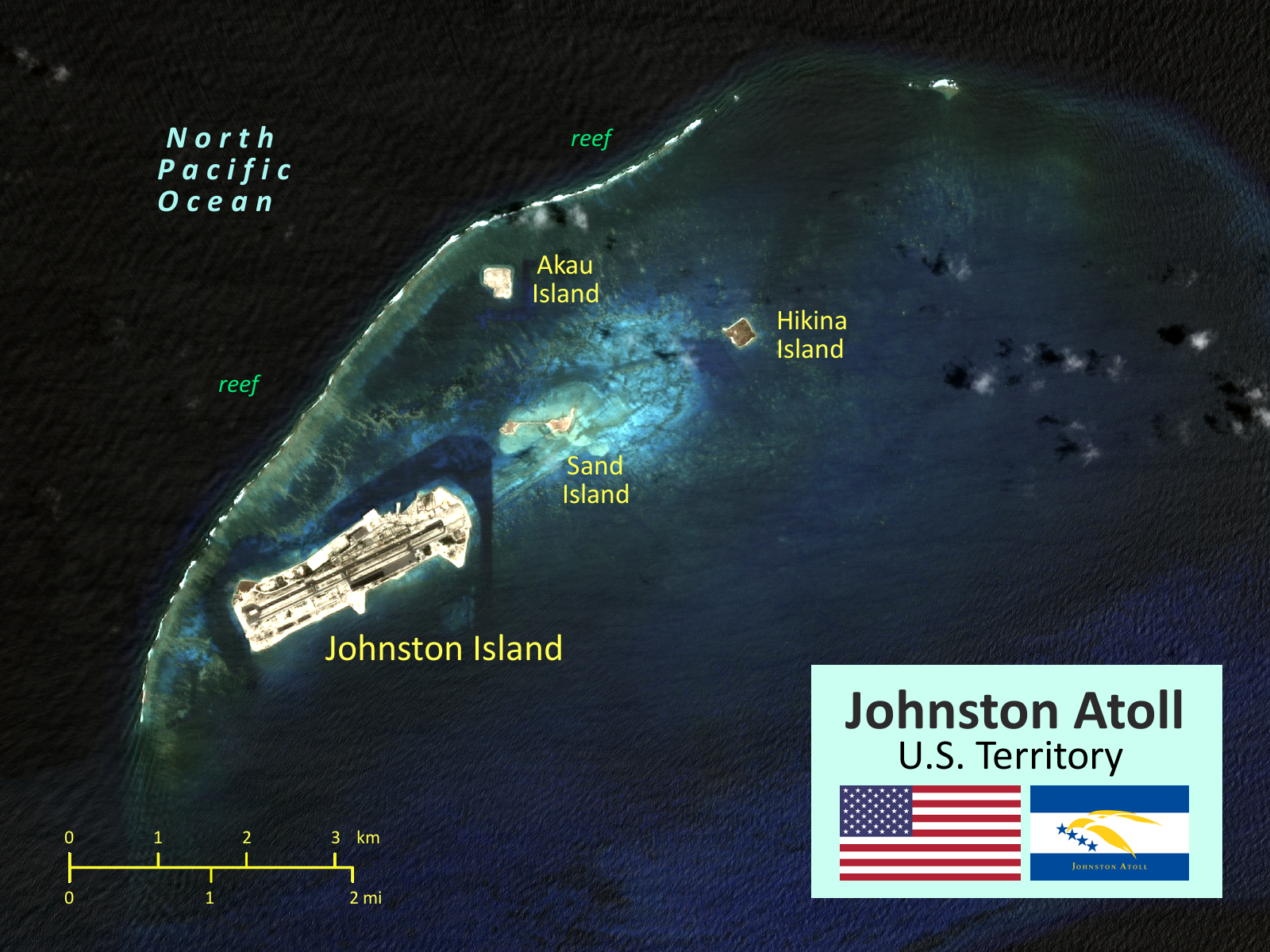
Das Johnston-Atoll (alter Name Cornwallis Island) ist ein Atoll im nördlichen Pazifik, 1150 km südwestlich von Hawaii gelegen. Die Inselgruppe gehört politisch zu den Vereinigten Staaten und wird von diesen als sogenanntes „nichtinkorporiertes Territorium“ zu den United States Minor Outlying Islands gezählt.
约翰斯顿环礁(英语:Johnston Atoll),位于北太平洋中部,是波利尼西亚群岛的组成部分之一,属于美国无建制领土。东北距夏威夷檀香山1328公里,有重要战略地位。


塞班岛(英语:Saipan),为美国自治邦北马里亚纳群岛面积最大的岛屿,也是邦内近九成人口所在地。该岛为珊瑚岛,沿西海岸有潟湖,山脉南北延伸。最高点塔波查山海拔479米。
北马里亚纳群岛自由邦的行政中心是塞班岛的卡皮托尔希尔,但由于整个塞班岛是一个单独的市,所以大部分出版物把塞班岛称作北马里亚纳群岛的首府。
Saipan ist nach Guam die zweitgrößte Insel der sich über 650 Kilometer erstreckenden Inselkette der Marianen im Pazifischen Ozean. Die Insel ist seit der Besetzung 1944 durch die USA während des Zweiten Weltkrieges US-Außengebiet. Saipan war zuvor Kolonie von Spanien, Deutschland und Japan.

 Geography

 Alaska-AK
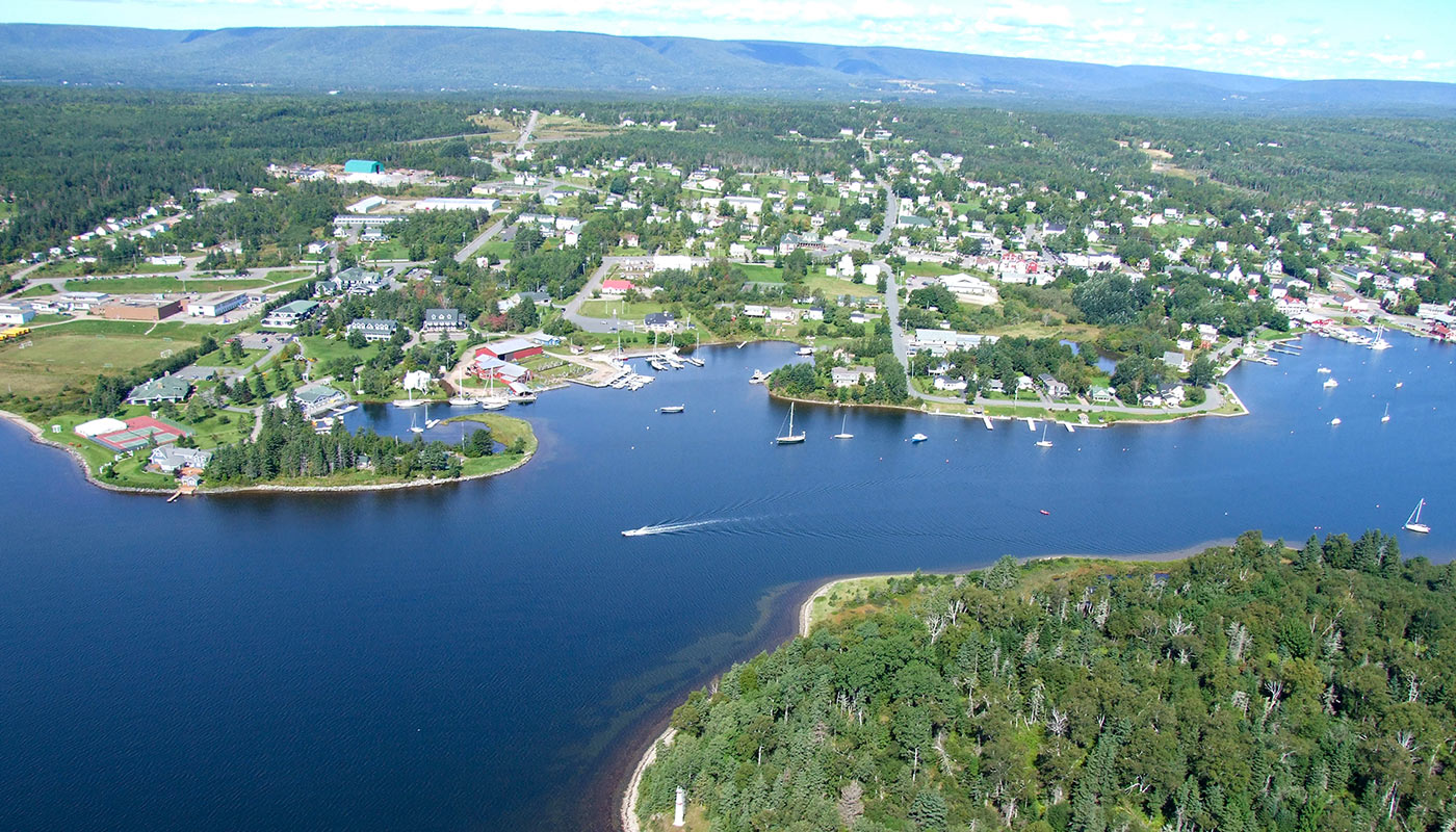
 Nova Scotia-NS