
Deutsch-Chinesische Enzyklopädie, 德汉百科
 Kroatien
 *Mittelmeer

 Abruzzo
 Albanien
 Bernsteinstraße
 Bosnien-Herzegowina

 Emilia-Romagna

 Friuli-Venezia Giulia
 Italien
 Kroatien

 Marche

 Molise
 Montenegro

 Puglia
 Slowenien

 Veneto
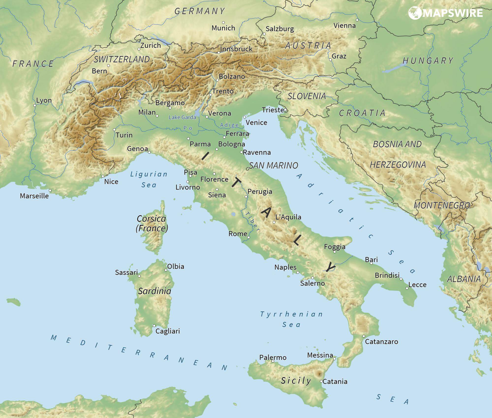
亚得里亚海(意大利语:Mar Adriatico,斯洛文尼亚语:Jadransko morje,克罗地亚语:Jadransko more,阿尔巴尼亚语:Deti Adriatik),是地中海的一部分水域,分隔了意大利半岛(亚平宁半岛)和巴尔干半岛,也分隔了亚平宁山脉与狄那里克阿尔卑斯山脉及其临近地区。亚得里亚海西岸属于意大利,东岸则分别属于斯洛文尼亚、克罗地亚、波斯尼亚和黑塞哥维那、黑山和阿尔巴尼亚。亚得里亚海透过位于其南部的奥特朗托海峡与爱奥尼亚海相连。波河、阿迪杰河、奥凡托河等河流流入亚得里亚海;海中有近1200个岛屿,其中只有69个有人居住。
Das Adriatische Meer, kurz auch die Adria (lateinisch Mare Adriaticum; italienisch Mare Adriatico; bosnisch, kroatisch und serbisch Jadransko more oder kurz Jadran; slowenisch Jadransko morje; albanisch Deti Adriatik oder kurz Adriatiku), ist das lang gestreckte nördliche Seitenbecken des Mittelmeeres zwischen der Apenninhalbinsel und Balkanhalbinsel. Es ist nach der Stadt Adria in Italien (Provinz Rovigo) benannt. Zum Adriatischen Meer wird alles gerechnet, was nördlich der Straße von Otranto liegt.
アドリア海(アドリアかい、英: Adriatic Sea ; イタリア語: Mar Adriatico ; クロアチア語: Jadransko more)は、地中海の海域の一つ。イタリア半島とバルカン半島に挟まれている。
The Adriatic Sea (/ˌeɪdriˈætɪk/) is a body of water separating the Italian Peninsula from the Balkans. The Adriatic is the northernmost arm of the Mediterranean Sea, extending from the Strait of Otranto (where it connects to the Ionian Sea) to the northwest and the Po Valley. The countries with coasts on the Adriatic are Albania, Bosnia and Herzegovina, Croatia, Italy, Montenegro and Slovenia. The Adriatic contains over 1,300 islands, mostly located along the Croatian part of its eastern coast. It is divided into three basins, the northern being the shallowest and the southern being the deepest, with a maximum depth of 1,233 metres (4,045 ft). The Otranto Sill, an underwater ridge, is located at the border between the Adriatic and Ionian Seas. The prevailing currents flow counterclockwise from the Strait of Otranto, along the eastern coast and back to the strait along the western (Italian) coast. Tidal movements in the Adriatic are slight, although larger amplitudes are known to occur occasionally. The Adriatic's salinity is lower than the Mediterranean's because the Adriatic collects a third of the fresh water flowing into the Mediterranean, acting as a dilution basin. The surface water temperatures generally range from 30 °C (86 °F) in summer to 12 °C (54 °F) in winter, significantly moderating the Adriatic Basin's climate.
The Adriatic Sea sits on the Apulian or Adriatic Microplate, which separated from the African Plate in the Mesozoic era. The plate's movement contributed to the formation of the surrounding mountain chains and Apennine tectonic uplift after its collision with the Eurasian plate. In the Late Oligocene, the Apennine Peninsula first formed, separating the Adriatic Basin from the rest of the Mediterranean. All types of sediment are found in the Adriatic, with the bulk of the material transported by the Po and other rivers on the western coast. The western coast is alluvial or terraced, while the eastern coast is highly indented with pronounced karstification. There are dozens of marine protected areas in the Adriatic, designed to protect the sea's karst habitats and biodiversity. The sea is abundant in flora and fauna—more than 7,000 species are identified as native to the Adriatic, many of them endemic, rare and threatened ones.
The Adriatic's shores are populated by more than 3.5 million people; the largest cities are Bari, Venice, Trieste and Split. The earliest settlements on the Adriatic shores were Etruscan, Illyrian, and Greek. By the 2nd century BC, the shores were under Rome's control. In the Middle Ages, the Adriatic shores and the sea itself were controlled, to a varying extent, by a series of states—most notably the Byzantine Empire, the Croatian Kingdom, the Republic of Venice, the Habsburg Monarchy and the Ottoman Empire. The Napoleonic Wars resulted in the First French Empire gaining coastal control and the British effort to counter the French in the area, ultimately securing most of the eastern Adriatic shore and the Po Valley for Austria. Following Italian unification, the Kingdom of Italy started an eastward expansion that lasted until the 20th century. Following World War I and the collapse of Austria-Hungary and the Ottoman Empire, the eastern coast's control passed to Yugoslavia and Albania. The former disintegrated during the 1990s, resulting in four new states on the Adriatic coast. Italy and Yugoslavia agreed on their maritime boundaries by 1975 and this boundary is recognised by Yugoslavia's successor states, but the maritime boundaries between Slovenia, Croatia, Bosnia-Herzegovina, and Montenegro are still disputed. Italy and Albania agreed on their maritime boundary in 1992.
Fisheries and tourism are significant sources of income all along the Adriatic coast. Adriatic Croatia's tourism industry has grown faster economically than the rest of the Adriatic Basin's. Maritime transport is also a significant branch of the area's economy—there are 19 seaports in the Adriatic that each handle more than a million tonnes of cargo per year. The largest Adriatic seaport by annual cargo turnover is the Port of Trieste, while the Port of Split is the largest Adriatic seaport by passengers served per year.
La mer Adriatique (du latin : Mare Hadriaticum ou Mare Adriaticum) est une mer séparant la péninsule italienne de la péninsule balkanique. L'Adriatique est le bras de la Méditerranée situé le plus au nord en s'étendant du canal d'Otrante (où elle rejoint la mer Ionienne) jusqu'aux villes de Venise et de Trieste et à l'embouchure du Pô. Les pays côtiers sont l'Italie, la Slovénie, la Croatie, la Bosnie-Herzégovine, le Monténégro et l'Albanie, ainsi que la Grèce par l'île de Corfou.
Il mare Adriatico è l'articolazione del mar Mediterraneo orientale situata tra la penisola italiana e la penisola balcanica; suddiviso in Alto Adriatico, Medio Adriatico e Basso Adriatico, bagna sei Paesi: Italia, Slovenia, Croazia, Bosnia ed Erzegovina, Montenegro e Albania, confinando a sud-est con il Mar Ionio.
El mar Adriático (del latín, Mare Hadriaticum) es un golfo estrecho y alargado que forma parte del mar Mediterráneo. Se encuentra situado entre la península Itálica, al oeste, y la península de los Balcanes, al este, con una anchura máxima de unos 200 km, y una longitud de unos 800 km. Su extremo meridional limita con el mar Jónico, del que lo separa el canal de Otranto. Su superficie total es de, aproximadamente, 160 000 km².
Las costas occidental, septentrional, y parte de la oriental corresponden a Italia (60% de la longitud de costa del Adriático), mientras que el resto de la costa oriental corresponde a Croacia, Eslovenia, Bosnia y Herzegovina, Montenegro y Albania. Algunos de los ríos que desembocan en el Adriático son el Reno, el Po, el Adigio, el Brenta, el Piave y el Neretva.
La costa del Adriático concentra un gran número de centros turísticos, como Venecia, que recibe el nombre de «Reina del Adriático». Tras la división de Yugoslavia, la costa croata se ha convertido también en un destino turístico muy popular.
Sus aguas sostienen industria pesquera, y se llevan a cabo prospecciones petrolíferas en este mar. Durante los años 1990, varias investigaciones revelaron que sus niveles de contaminación son muy altos.
En las últimas décadas el gobierno de Italia ha intentado hacer de él una barrera contra la inmigración ilegal, en su mayor parte proveniente de Albania.
Адриати́ческое мо́ре (итал. mare Adriatico, эмил.-ром. Mèr Adriâtic, вен. Mar Adriàtico, неап. Mar Adriateco, словен. Jadransko morje, сербохорв. Jadransko more/Јадранско море, алб. Deti Adriatik, лат. mare Hadriaticum), также Адриатика — полузамкнутое море, часть Средиземного моря между Апеннинским и Балканским полуостровами. Омывает берега Италии (более 1000 км), Словении (47 км), Хорватии (1777 км), Боснии и Герцеговины (20 км), Черногории (200 км), Албании (472 км).

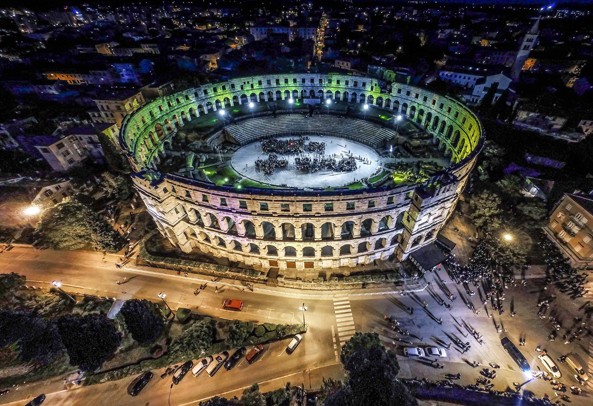
普拉竞技场(克罗地亚语:Amfiteatar u Puli)是位于克罗地亚西北部伊斯特拉半岛城市普拉的一座古罗马时期的圆形竞技场[1]。现在则是音乐会和电影节的会场。普拉竞技场修建于罗马帝国首任皇帝奥古斯都在位时期。
Das römische Amphitheater in Pula (Kroatien) (kroatisch: Pulska Arena) ist das sechstgrößte antike Amphitheater.[1] Im Endausbau (seit 81 n. Chr.) bestand es aus zwei übereinander angeordneten Arkadenreihen mit 72 Bögen aus weißem Kalkstein. Das Obergeschoss ist von 64 rechteckigen Fensternischen durchbrochen. Das Gebäude erreichte meerseitig eine Höhe von 32,45 Metern. Da sich der Bau im Osten an einen Hügel lehnt, ist die Fassade dort wesentlich niedriger und in der unteren Bogenreihe sind 32 Bögen als Anpassung an das Gelände teilweise oder ganz weggelassen worden. Im Inneren folgten die Sitzreihen der Hanglage. Damit bot es Platz für 26.000 Zuschauer.[1] In der Antike diente die Arena für Gladiatorenkämpfe und zeitweise für die Darstellung von Naumachien, also Seeschlachten.
Im Untergeschoss des Theaters zeigt ein Museum die Geschichte des Weinbaus in römischer Zeit. Auch die Stile und Verwendungen von Amphoren und die antiken Handelsbeziehungen Istriens werden dargestellt.
プーラ円形闘技場(クロアチア語: Amfiteatar u Puli,英語: Amphitheatre of Pula)またはプーラ・アレナ(Pulska Arena,Pula Arena)は、クロアチア北西部のイストリア半島先端のプーラにある古代ローマ時代に造られた円形闘技場。
古代ローマ時代には剣闘士の戦いや剣闘士と猛獣の戦いなどの見世物が、中世には騎士の模擬戦争が行われた[1]。現在はコンサートや映画祭等の会場[1]として用いるため、陸側の下層階客席などが復元されている。また剣闘士の戦いのショー[1]が行われることもある。
この闘技場はローマ帝国初代皇帝アウグストゥス(在位 前27年 - 14年)[2]から第9代皇帝ウェスパシアヌス(在位 69年 - 79年)[1]の治世のころ、中央政府の予算にて建設されたと考えられている。建物はアドリア海に向かって傾斜する斜面に建てられていて、長辺132.5m、短辺105.1mの楕円形で敷地面積11,466m2であり[2]、中央の平らな競技スペース(アレナ)も67.9m×41.6mの楕円形である。また、地上からの高さは海側の最も高い所で32.45mである[2]。客席部分の建物は、海側において地上から嵩上げに使われた壁の外観を呈する1階部分と、アーチ構造のファサードを持つ2階から4階となっており、総観客数23,000人を収容できた[2]と考えられている。なお、コンサート会場等として改修された現在の観客収容数は約5,000人である[1]。
楕円の長辺の南側はプーラ旧市街方向を向いており、わずかに大きな4m幅のアーチを持つ施設のメイン・ゲートとなっている。2階部分のアーチ窓は楕円の全周で72箇所あり、最上階の4階の長方形の窓は長辺・短辺端の4箇所の塔構造の部分を除いて全周で64箇所である[2]。
競技スペースの下には地階があり、出し物に使われる猛獣等を格納したり、資機材を保管するために使われていたと考えられている。現在、地階は出土品の展示スペースとなっている[3]。
5世紀頃には闘技場は使われなくなり[2]、その石材が他の建物の建築資材として持ち去られ、廃墟となっていった。
The Pula Arena (Croatian: Pulska Arena, Italian: Arena di Pola) is the name of the amphitheatre located in Pula, Croatia. The Arena is the only remaining Roman amphitheatre to have four side towers and with all three Roman architectural orders entirely preserved. It was constructed in 27 BC – 68 AD[1] and is among the six largest surviving Roman arenas in the World.[1] A rare example among the 200 surviving Roman amphitheatres, it is also the best preserved ancient monument in Croatia.
The amphitheatre is depicted on the reverse of the Croatian 10 kuna banknote, issued in 1993, 1995, 2001 and 2004.[2]
L'amphithéâtre de Pula est un amphithéâtre romain bien conservé, situé à Pula, en Istrie (Croatie).
Il fut construit au Ier siècle, sous le règne de l'empereur Auguste, puis fut reconstruit et agrandi par l'empereur Vespasien, en 79 apr. J.-C..
De nombreux combats de gladiateurs se déroulèrent dans son enceinte durant l'Antiquité. Au Moyen Âge, il fut utilisé pour divers combats, puis ses pierres furent en partie remployées dans d'autres édifices de la ville de Pula, notamment le château, au XVe siècle.
L’anfiteatro di Pola (chiamato anche Arena di Pola in croato: Pulska Arena) è per grandezza il sesto nel suo genere. Il suo nome deriva dal latino ărēna, che indica la sabbia che ricopriva le platee degli anfiteatri romani. Tra i polesi il monumento emblema della città, dal grandissimo valore simbolico ed affettivo, è chiamato solitamente Rena, dal dialetto istroveneto.
L'anfiteatro venne costruito tra il 2 a.C. ed il 14 d.C. sotto l'imperatore Augusto, prelevando il materiale dalle note cave di pietra situate alla periferia della città ed ancora oggi esistenti. In seguito, l'imperatore Vespasiano, che aveva commissionato il Colosseo a Roma, lo fece ampliare (secondo la leggenda, egli voleva rendere omaggio ad una sua amante del luogo).
Come il Colosseo, veniva utilizzato prevalentemente per combattimenti di gladiatori o per naumachie. Si presume che sia rimasto intatto, seppure in uno stato di sempre maggiore trascuratezza ed abbandono, fino al XV secolo. In seguito sarebbe stato saltuariamente utilizzato come cava di pietra per alcune costruzioni della Repubblica di Venezia, oltreché degli abitanti locali. Salì infatti all'onore delle cronache nel 1583 quando al Senato veneziano, versando Pola in uno stato di sempre maggior decadenza e desolazione, si propose di smontare l'Arena pezzo per pezzo e di ricostruirla a Venezia. A sventare tal proposito fu soprattutto l'azione del senatore veneziano Gabriele Emo e per questo suo impegno, nell'anno successivo la città di Pola pose su una torre dell'Arena, lato mare, una lapide a perenne memoria e gratitudine.
Fu oggetto di ampio restauro durante l'epoca napoleonica.
Viene utilizzato tutt'oggi, similmente all'Arena di Verona: è un ambito centro di teatro e musica e nel 1993 ha ospitato il festival di Pola e gli Histria festivals, oltre a una puntata di Giochi senza frontiere nel 1981[1]. Ogni estate è il palco privilegiato del Pola Film Festival. Personaggi di fama mondiale come Sting, Julio Iglesias, Anastacia, Luciano Pavarotti, Grace Jones, Norah Jones, Alanis Morissette, David Gilmour si sono esibiti in questa arena. Attualmente, è in grado di ospitare cinquemila spettatori.
El anfiteatro de Pula, también conocido como Pula Arena, es un anfiteatro romano ubicado en la ciudad croata de Pula. Se trata del único anfiteatro conservado que cuenta con cuatro torres y con los tres órdenes arquitectónicos clásicos perfectamente preservados en altura. Fue levantado entre el año 27 a. C. y el 81 d. C.1 y por sus dimensiones está entre los seis anfiteatros romanos más grandes que se pueden contemplar en la actualidad.1 Asimismo, es el edificio romano mejor conservado de toda Croacia, motivo por el que aparece representado en el reverso de los billetes de diez kuna desde el año 1993.2 El excelente estado de conservación de este edificio romano ha permitido estudiar a fondo las técnicas constructivas de la Antigua Roma. En la actualidad, el Pula Arena alberga la celebración de actuaciones musicales.
Levantado junto al mar, los muros exteriores están hechos de sillares regulares de piedra caliza. La fachada que da hacia el mar tiene tres pisos y una altura máxima que ronda los 30 m, mientras que el resto de su perímetro tan solo tiene dos alturas porque aprovecha el desnivel del terreno. Los dos primeros niveles presentan 72 arcos de medio punto cada uno, mientras que el último cuenta con 64 arcos adintelados.
El eje mayor de la planta elíptica del anfiteatro tiene 132,45 m y el menor 105,1 m. La cávea (gradas) pudo acomodar en origen a unos 23 000 espectadores en sus 40 escalones, apoyados en parte en la pendiente que baja hacia la costa. La arena del recinto tiene unas dimensiones de 67,95 m por 41,65 m y queda separada de la cávea por un murete en el que se abren quince puertas. Debajo de la arena existen una serie de pasillos y dependencias subterráneas que en origen se empleaban para cobijar a las fieras y los gladiadores que intervenían en los espectáculos. Bajo las gradas también existen diversas dependencias y almacenes.
Cada una de las cuatro torres tiene dos cisternas que se llenaban con agua perfumada, que se usaba tanto para abastecer una fuente como para rociar a los espectadores. Las gradas del anfiteatro podían cubrirse con velarii, unos grandes toldos que protegían a los asistentes del sol o la lluvia.
Амфитеа́тр Пу́лы — памятник древнеримской истории и архитектуры. Расположен в городе Пула, Хорватия. Это единственная из сохранившихся арен, которая имеет 4 башни и все три римских архитектурных ордера. При этом по своим размерам амфитеатр занимает 6-е место в мире среди подобных сооружений.


 Albanien
 Bosnien-Herzegowina
 Bulgarien
 Griechenland
 Kosovo
 Kroatien
 Montenegro
 Nordmazedonien
 Rumänien
 Serbien
 Slowenien
 Türkei
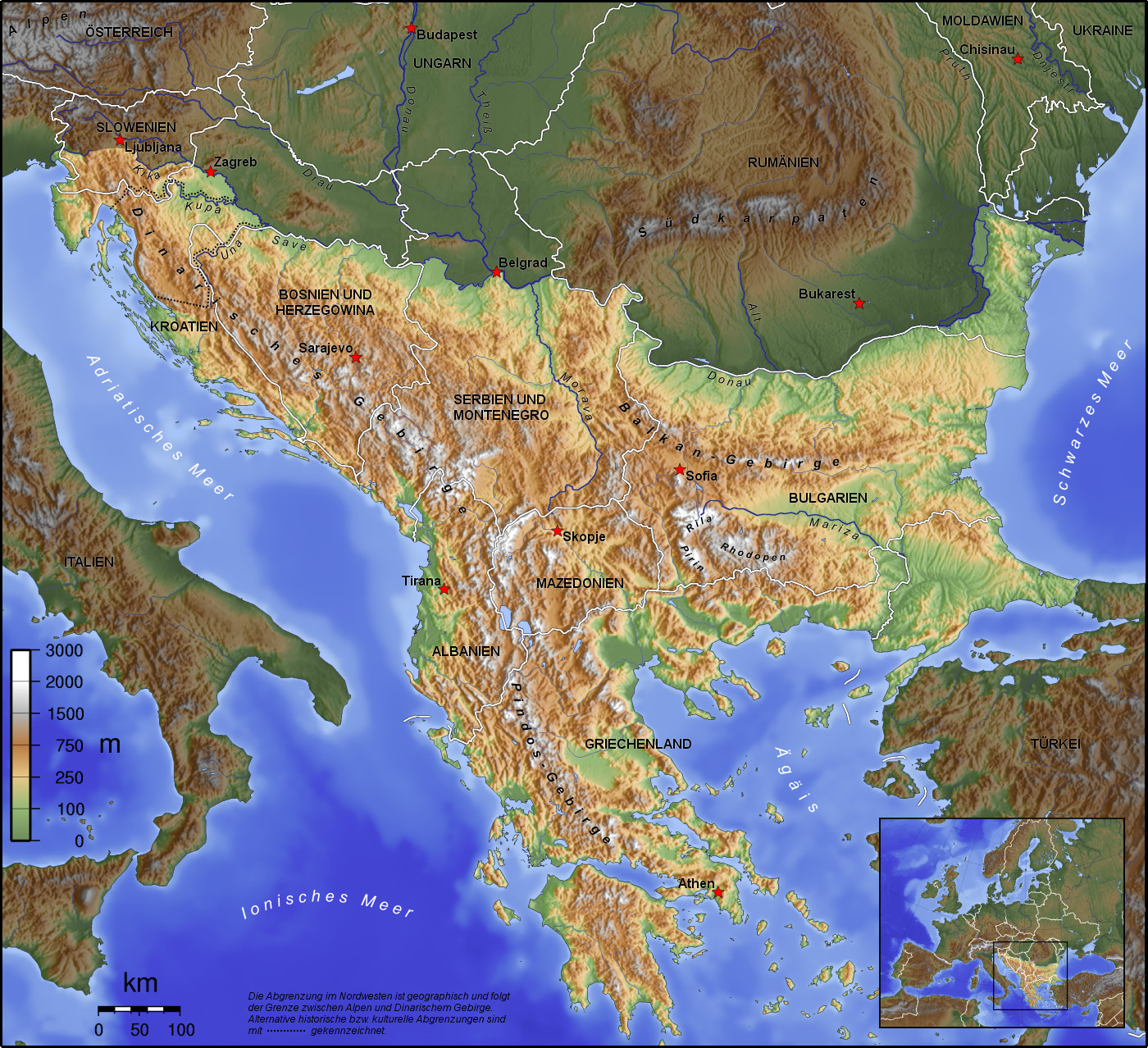
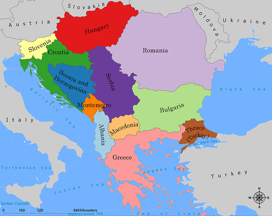
巴尔干半岛(Balkans),是一个地理名词,用以描述欧洲的东南隅位于亚得里亚海和黑海之间的陆地,详细的范围依照定义不同有许多种说法。该地约有55万平方公里和近5500万人口。在古希腊时代,巴尔干半岛被称为哈伊莫司半岛。该地区的名称来自于一条通过保加利亚中心到东塞尔维亚的巴尔干山脉。[1]
巴尔干地区向来存在诸多矛盾,其中既有宗教矛盾,也有领土争端。由于半岛的地缘政治重要性,由此而来的列强干涉致使这一地区的矛盾频繁被放大为战争,因此又有欧洲火药库之称。不过近年巴尔干半岛(南斯拉夫内战后至今)已实现停火与和平,只是偶然间在领土主权上有些纠纷,例如科索沃主权问题。第一次世界大战的触发点之——萨拉热窝事件亦是发生在巴尔干半岛上。
目前,巴尔干半岛共有11个国家,共有面积是47.6万平方公里,人口1.3亿。
南欧相邻地中海的三大半岛,从东向西分别为巴尔干半岛、意大利半岛(亚平宁半岛)、伊比利亚半岛。
半岛地处欧、亚、非三大陆之间,是欧、亚联系的陆桥,南临地中海重要航线,东有博斯普鲁斯海峡和达达尼尔海峡扼黑海的咽喉,地理位置极为重要。地形以山地为主,喀尔巴阡山以南多为山丘及石灰岩地形,以北多以为平原为主。半岛西部有迪纳拉-品都斯山脉,中东部有喀尔巴阡-老山(巴尔干)山脉。老山山脉是阿尔卑斯、喀尔巴阡山的延伸,经南斯拉夫东部,横贯保加利亚中部,直临黑海。东西两列山脉之间是古老的罗多彼山脉和马其顿山丛,最高峰穆萨拉峰,海拔2925米。半岛上平原分布零散,仅萨瓦河、多瑙河、马里查河谷较宽广。 巴尔干半岛位于欧洲东南部,三面被水环绕:西邻亚德里亚海、南面是地中海(包括爱奥尼亚海和爱琴海)和马尔马拉海、东边是黑海。其北部边界通常被定为多瑙河、萨瓦河和库帕河。[2] [3]巴尔干半岛包括49万平方公里土地。
Die Balkanhalbinsel (auch kurz Balkan, oft synonym mit Südosteuropa verwendet) ist eine geographisch nicht eindeutig definierte Halbinsel im Südosten Europas. Sie ragt in das Mittelmeer und ist nach dem Balkangebirge benannt. Der größte Staat auf der Halbinsel ist Griechenland, gefolgt von Bulgarien (in dem sich der Großteil des Balkangebirges befindet), Serbien, Bosnien und Herzegowina, Albanien, Nordmazedonien, Montenegro und dem Kosovo. Die Staatsgebiete von Serbien, Kroatien, Rumänien, Slowenien und der Türkei, die durch ihre thrakischen Provinzen Anteil am Balkan hat, reichen über die Grenzen der Balkanhalbinsel hinaus.
Ungeachtet der Herleitung des geographischen Namens sind das dominierende Gebirge des Balkans die Dinariden im westlichen Teil der Halbinsel; ihr höchster Gipfel Jezerca (2694 m) liegt in Albanien. Die höchste Erhebung des Balkans ist der Gipfel Musala (2925 m) im Rila-Gebirge. Das Balkangebirge erreicht 2376 m maximale Gipfelhöhe.
バルカン半島(バルカンはんとう、Balkan Peninsula)、またはバルカン(Balkans)は東南ヨーロッパにある地理的領域であり、地理的・歴史的に様々な意味合いと定義付け[1][2]の下で使用される概念である[3]。名称はバルカン山脈からきている。この山脈はセルビアとブルガリアの国境から黒海沿岸まで、ブルガリア全土を横断している。バルカン半島は北西をアドリア海に、南西をイオニア海に、南と南東をエーゲ海に、そして東と北東を黒海によって区切られている[4]。北側の境界は論者と文脈によって様々に定義されていて不定である。バルカン半島の最高地点はリラ山地にあるムサラ山(2925メートル)である。
バルカン半島という概念はドイツの地理学者アウグスト・ツォイネによって1808年に創り出された[5][6]。彼はバルカン山脈がディナル・アルプス山脈と共にアドリア海から黒海まで東南ヨーロッパを区分していると誤認していた[5]。この地域はかつてオスマン帝国の属領であり、バルカン半島という用語は19世紀にはヨーロッパ・トルコ(European Turkey)の同義語であった[7]。バルカン半島という言葉は地理学的というよりもむしろ地政学的定義を持っており、この傾向は20世紀初頭にユーゴスラヴィア王国が成立するとさらに増した。バルカン半島を定義する自然境界が「半島」の学術的定義と一致していないため、現代の地理学者は「バルカン半島」という考え方を拒絶しており、通常はバルカンを「地域」として議論を行っている。この言葉には徐々に、特に1990年代以降、バルカニゼーション(バルカン化)のプロセスと関連して汚名と侮蔑的意味合いが与えられており[4][8]、それ故に東南ヨーロッパ(南東ヨーロッパ)という別の用語が使用されている。
The Balkans (/ˈbɔːlkənz/ BAWL-kənz), also known as the Balkan Peninsula, is a geographic area in Southeast Europe with various geographical and historical definitions.[2][3][4] The region takes its name from the Balkan Mountains that stretch throughout the whole of Bulgaria. The Balkan Peninsula is bordered by the Adriatic Sea in the northwest, the Ionian Sea in the southwest, the Aegean Sea in the south, the Turkish Straits in the east, and the Black Sea in the northeast. The northern border of the peninsula is variously defined.[5] The highest point of the Balkans is Mount Musala, 2,925 metres (9,596 ft), in the Rila mountain range, Bulgaria.
The concept of the Balkan Peninsula was created by the German geographer August Zeune in 1808,[6] who mistakenly considered the Balkan Mountains the dominant mountain system of Southeast Europe spanning from the Adriatic Sea to the Black Sea. The term Balkan Peninsula was a synonym for Rumelia in the 19th century, the European provinces of the Ottoman Empire. It had a geopolitical rather than a geographical definition, which was further promoted during the creation of the Kingdom of Yugoslavia in the early 20th century. The definition of the Balkan Peninsula's natural borders do not coincide with the technical definition of a peninsula; hence modern geographers reject the idea of a Balkan peninsula, while historical scholars usually discuss the Balkans as a region. The term has acquired a stigmatized and pejorative meaning related to the process of Balkanization,[5][7] and hence the preferred alternative term used for the region is Southeast Europe.
Les Balkans sont une des trois « péninsules » de l'Europe du Sud, mais cette appellation traditionnelle est parfois contestée en l'absence d'un isthme : les géographes préfèrent le terme de « région ». Elle est bordée par des mers sur trois côtés : la mer Adriatique et la mer Ionienne à l'ouest, la mer Égée au sud et la mer de Marmara et la mer Noire à l'est. Au nord, on la délimite généralement par les cours du Danube, de la Save et de la Kupa. Cette région couvre une aire totale de plus de 550 000 km2 et regroupe une population de près de 53 millions d’habitants.
La penisola balcanica, nota anche come Balcani (dalla forma abbreviata di Monti Balcani, sistema montuoso tra Bulgaria e Serbia; dal turco balkan ‘monteʼ[2]), è una penisola dell'Europa orientale; è delimitata a ovest dal mare Adriatico, a sud-ovest dal mar Ionio, a est dal mar Nero, a sud-est dal mar di Marmara, e a sud dal mar Egeo.
Come spesso accade per le penisole, incerta è la definizione del suo confine sulla terraferma, aggravato dal fatto che si tratta di uno dei suoi confini più estesi. Non aiuta inoltre la definizione di questa linea di demarcazione il fatto che il territorio presenta al suo interno grandi differenze e frammentazioni per storia, nazionalità, lingua, cultura e religione delle popolazioni che vi abitano.
Solitamente se ne stabilisce il confine sul Danubio e sul suo affluente Sava. In questo modo si include in tale area anche parte della Slovenia e della Romania (paese di lingua romanza orientale), che però storicamente hanno avuto a che fare con i Balcani solo dopo la dissoluzione dell'Impero asburgico. Secondo il geografo Vittorio Vialli, la delimitazione a nord è rappresentata dalla linea geografica Istria-Odessa. Esclude dalla regione la Slovenia l'interpretazione del confine che include il fiume Kupa, facendolo partire dalla città di Fiume e raggiungendo le foci del Danubio.[3] In tal modo confina a ovest con la cosiddetta regione geografica italiana,[4][5] che include anche territori non facenti parte della Repubblica Italiana. La definizione politica di Balcani venne in uso nel XIX secolo per designare i paesi europei interessati dall'espansione e dalla successiva dissoluzione dell'Impero ottomano.[6]
Del resto le caratteristiche del territorio, solcato da catene montuose parallele che ostacolarono il movimento in direzione nord-sud e una colonizzazione uniforme già ai tempi dell'espansione greco-romana, e la sua stessa collocazione geografica contribuiscono a spiegare le tormentate vicende storiche che hanno caratterizzato la penisola.[7]
Fino al 1975 la penisola era attraversata dal Balkan Express, un treno con partenza da Vienna e arrivo a Istanbul. Il clima è continentale nel nord e nell’est del territorio (con estati calde e inverni molto rigidi), mentre l’area occidentale e la Grecia hanno un clima mediterraneo.
La península balcánica o península de los Balcanes es una de las tres grandes penínsulas del sur de Europa, continente al que está unida por los montes Balcanes al este (cordilleras que han dado nombre a la península) y los Alpes Dináricos, al oeste.
Балка́нский полуо́стров (хорв. Balkanski poluotok, словен. Balkanski polotok, серб. Балканско полуострво, рум. Peninsula Balcanică, болг. и макед. Балкански полуостров, алб. Gadishulli Ballkanik, греч. Βαλκανική χερσόνησος, тур. Balkan Yarımadası, босн. Balkansko poluostrvo, черног. Balkansko poluostrvo) расположен на юго-востоке Европы. Площадь — около 467 тыс. км².
С юга, юго-запада и юго-востока омывается: Адриатическим, Ионическим, Мраморным, Критским, Эгейским и Чёрным морями.
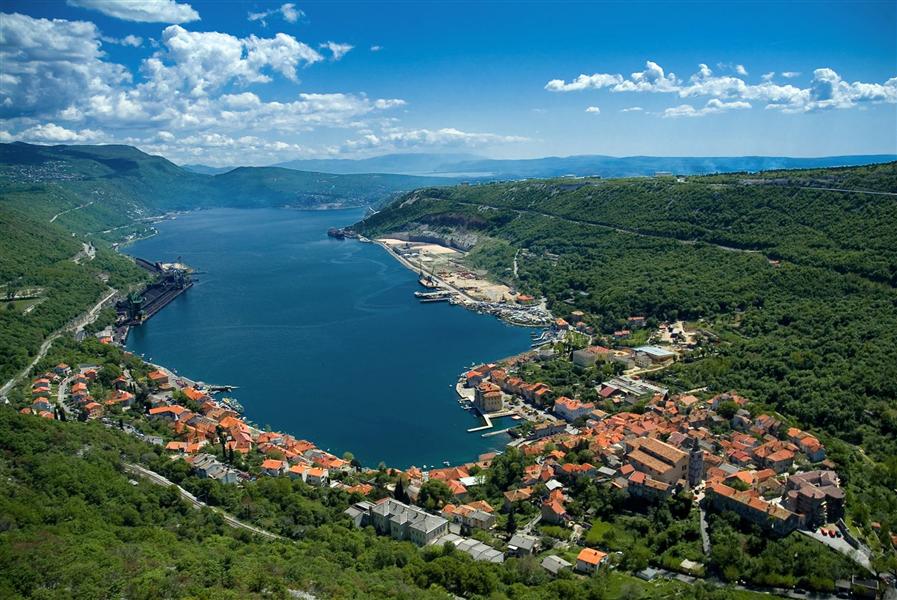
Северной границей полуострова считается условная линия, проведённая от устья Дуная, по рекам Дунай, Сава и Купа (Колпа), а от истока последней в Горском Котаре (Хорватия) — до залива Кварнер с портом Риека (Хорватия).
Рельеф преимущественно гористый (Стара-Планина, Родопы, Динарское нагорье, Пинд). По размерам в Европе уступает только Скандинавскому и Пиренейскому полуостровам.
 Albanien
 Bosnien-Herzegowina
 Bulgarien
 Griechenland
 Kosovo
 Kroatien
 Montenegro
 Nordmazedonien
 Rumänien
 Serbien
 Slowenien
 Türkei

 Geographie
 Unternehmen
 Architektur

 Geschichte
 Musik
Musik
 Sport
Sport
 Transport und Verkehr