Deutsch-Chinesische Enzyklopädie, 德汉百科
 China
China
 Architektur
 Geschichte


黄鹤楼位于中国湖北省武汉市武昌蛇山上,是江南四大名楼之一,中国国家旅游胜地四十佳之一。黄鹤楼共5层,高50.4米。始建于三国时代吴黄武二年(公元223年),距今已有1780多年历史,历代屡修屡毁,现在的黄鹤楼是于1985年重建的。
Errichtet wurde die Anlage im Jahre 223, während der Zeit der drei Reiche (三國 / 三国), als Holzkonstruktion. Im Laufe der Jahre wurde der Turm öfter durch Feuer, aber auch durch wechselnde Herrscher zerstört. Somit durchlief er unterschiedliche Stadien des Aussehens. Im Inneren des Turms findet man heute Holztafeln und Modelle, die die Geschichte und die Veränderungen mit der Zeit erläutern und zeigen.
Cui Hao (chin. 崔顥 / 崔颢 Pinyin Cuī Hào), ein gefeierter Dichter der Tang-Dynastie (唐朝), besuchte das Gebäude im frühen achten Jahrhundert. Sein Gedicht mit dem Namen „Huanghe-Turm“ machte den Turm zum bekanntesten Gebäude in Südchina.
Einem Gedicht des tangzeitlichen Literaten Li Taibo (701-62) verdankt der Turm der gelben Kraniche seinen Ruhm und die Tatsache, dass er nach dutzendfacher Zerstörung stets wieder neu errichtet wurde - zuletzt 1985. Das jetzt 51 m hohe Gebäude mit seinen fünf Stockwerken ist der imposanteste der »Drei großen Türme südlich des Yangzi« (die anderen stehen in Yueyang und Nanchang). Es befindet sich auf dem Schlangenberg (She Shan), gleich östlich der großen Yangzi-Brücke. Frühling und Winter tgl. 7.30-15.15 Uhr, Sommer und Herbst 7-18.30 Uhr, Eintritt 50 Yuan。
黄鶴楼(こうかくろう、簡体字: 黄鹤楼、拼音: )は、現在の中華人民共和国武漢市武昌区にかつて存在した楼閣。現在はほぼ同位置に再建された楼閣がある。武漢随一の名勝地であり、中国の『江南三大名楼』のひとつである。
李白の代表的な漢詩「黄鶴楼にて孟浩然の広陵に之くを送る」や崔顥の「黄鶴楼」にてその名を知られている。
三国時代の223年、呉の孫権によって軍事目的の物見櫓として建築されたが、後には主に観光目的の楼閣になった。唐の永泰元年(765年)に書かれた閻伯瑾「黄鶴楼記」に楼閣の盛大な様子を記している[1]。
黄鶴楼は幾度も焼失と再建が繰り返された。清の光緒10年(1884年)の火事で失われた後、1904年に湖北巡撫の端方の命令により黄鶴楼の旧蹟地に建てられた2階建ての西洋式の火の見櫓と1907年に張之洞の門生らに建てられた「奥略楼」があったが、両方とも1955年に武漢長江大橋の建設のために取り壊された[2]。
黄鶴楼には、以下のような伝承が残っている。
昔、辛氏という人の酒屋があった。そこにみすぼらしい身なりをした仙人がやってきて、酒を飲ませて欲しいという。辛氏は嫌な顔一つせず、ただで酒を飲ませ、それが半年くらい続いた。 ある日、道士は辛氏に向かって「酒代が溜まっているが、金がない」と言い、代わりに店の壁にみかんの皮で黄色い鶴を描き、去っていった。 客が手拍子を打ち歌うと、それに合わせて壁の鶴が舞った。そのことが評判となって店が繁盛し、辛氏は巨万の富を築いた。
その後、再び店に仙人が現れ、笛を吹くと黄色い鶴が壁を抜け出してきた。仙人はその背にまたがり、白雲に乗って飛び去った。
辛氏はこれを記念して楼閣を築き、黄鶴楼と名付けたという。
Yellow Crane Tower (traditional Chinese: 黃鶴樓; simplified Chinese: 黄鹤楼; pinyin: Huánghè Lóu) is a traditional Chinese tower located in Yellow Crane Tower Subdistrict, Wuchang District, Wuhan, in central China. The current structure was built in 1981, but the tower has existed in various forms since not later than AD 223. The current Yellow Crane Tower is 51.4 m (169 ft) high and covers an area of 3,219 m2 (34,650 sq ft). It situated on Snake Hill (蛇山), one kilometer away from the original site, on the banks of the Yangtze River in Wuchang District.
The Yuanhe Maps and Records of Prefectures and Counties, written almost 600 years after the construction of the tower, notes that after Sun Quan, founder of the kingdom of Eastern Wu, built the fort of Xiakou in 223, a tower was constructed at/on the Yellow Crane Jetty, west of Xiakou, and hence its name.[1][2]
The tower has been destroyed twelve times, both by warfare and by fire, in the Ming and Qing dynasties and was repaired on ten separate occasions. The last tower at the original site was built in 1868 and destroyed in 1884. In 1957, the Wuhan Yangtze River Bridge was built with one trestle of the bridge on the Yellow Crane Tower's site. In 1981, the Wuhan City Government commenced reconstruction of the tower at a new location, about 1 km (0.62 mi) from the original site, and it was completed in 1985.[3]
On January 31, 2018, Theresa May, Prime Minister of the United Kingdom, visited Wuhan and took pictures at the Yellow Crane Tower.[4]
La tour de la Grue jaune (Chinois: 黄鹤楼; Pinyin: Huánghè lóu), ou pavillon de la Grue jaune, est un bâtiment de grande importance pour l'histoire de l'art chinois, édifié à Wuhan, province de Hubei, dans la république populaire de Chine. Son plus haut balcon offre une belle vue du fleuve Yangtze à l'Ouest. À l'Est de la colline on peut également, pour quelques yuans, faire sonner la grande cloche du temple.
Elle est située sur Shéshān (蛇山, « Colline du serpent »), la tour a été détruite de nombreuses fois au cours de ces presque 2000 ans d'histoire et reconstruite de formes différents à chaque époque. La construction actuelle date de 1985 tente de conserver le style architectural des anciennes versions mais la structure est faite de matériaux modernes et possède un ascenseur.
Le premier bâtiment a été construit en 223, au cours de la période des Trois Royaumes, en bois. Au fil des années, la tour a été plusieurs fois détruite, souvent par le feu. Par conséquent, maintenant, à l'intérieur de la tour, à peu-près seules les tables sont en bois.
La Pagoda della Gru Gialla (cinese tradizionale: 黃鶴樓; cinese semplificato: 黄鹤楼; pinyin: Huáng Hè Lóu; letteralmente: "Torre della Gru Gialla") è un edificio di grande significato per la storia dell'arte, che sorge a Wǔhàn, nella provincia di Hubei, nella Repubblica popolare cinese. La pagoda si trova sul Monte Sheshan (conosciuto come la Collina del Serpente), al centro del quartiere di Wuchang e quindi vicino al Chang Jiang. Questa montagna si eleva sensibilmente al di sopra della città, per cui dalla Pagoda della Gru si ha una vista meravigliosa. La pagoda è una ricostruzione di un antico monumento di 1700 anni fa che fu elevato per ricordare la visita di un immortale che salì la collina in sella ad una gru gialla. Da qui il nome "Rupe della Gru Gialla".
La costruzione fu eretta nel 223, durante il Periodo dei Tre Regni (三國), come edificio in legno. Nel corso degli anni la torre fu distrutta sia dal fuoco,sia dai vari proprietari. Di conseguenza il suo aspetto attraversò diverse fasi. All'interno della torre si trovano oggi tavole e modelli di legno, che spiegano la storia ed i cambiamenti che ha subito nel corso del tempo.
Cuī Hào (崔颢), un celebre poeta della Dinastia Tang (唐朝), visitò la struttura agli inizi dell'VIII secolo. La sua poesia dal titolo "La Torre di Huanghe" rese la torre l'edificio più famoso della Cina meridionale.
La Torre de la Grulla Amarilla (en chino: 黄鹤楼, pinyin: Huáng Hè Lóu) es una torre histórica, construida originalmente en el 223 d. C. La estructura actual, sin embargo, fue reconstruida en 1981 a un kilómetro de distancia de su emplazamiento original, y tiene poco parecido con la Torre de la Grulla Amarilla original. Se sitúa en Sheshan (Colina de la Serpiente), en la orilla del río Yangtsé en Wuchang, Wuhan, en la provincia de Hubei, China.
El emplazamiento original de la torre era el Embarcadero de la Grulla Amarilla, al oeste de Xiakou. Los Mapas y Registros de Prefecturas y Condados de la época Yuanhe señala que cuando Sun Quan construyó el fuerte de Xiakou, había una torre que llevaba el nombre del Embarcadero.
Las guerras y los incendios destruyeron la torre muchas veces. Solo durante las dinastías Ming y Qing, la torre fue destruida siete veces, y fue reconstruida y reparada diez veces. La última vez que se construyó durante la dinastía Qing fue en 1868, y fue destruida en 1884. Su emplazamiento fue ocupado posteriormente por los bastidores del Puente de Wuhan sobre el río Yangtsé en 1957. En 1981, el gobierno de la ciudad de Wuhan decidió reconstruir la torre en una nueva localización, a un kilómetro de su emplazamiento original. La torre actual se completó en 1985.
 Tierwelt
 Geographie


'华山(亦称太华山,“华”字古亦作“崋”),五岳之一,又称西岳' 。位于中国陕西省华阴市城南,西距西安市区120公里,秦、晋、豫黄河三角洲交汇处,南接秦岭,北瞰黄河,扼西北进出中原之门户。华山山体倚天拔地,四面如削,更有千尺幢、百尺峡、苍龙岭、鹞子翻身、长空栈道等十分险峻之地,被誉为“奇险天下第一山”。华山共有五峰,即东峰朝阳,西峰莲花,中峰玉女,南峰落雁,北峰云台。南峰落雁,为太华极顶,海拔2154.9米;西峰最险,海拔2082米;北峰最低,海拔1614.7米。另外,南峰落雁、东峰朝阳,西峰莲花,合称“天外三峰”。
华山同时也是道教名山,是三十六洞天中的第四洞天。华山自古以来就是负有盛名的胜地,传说萧史在此吹箫引来秦穆公女弄玉倾慕,隋唐孙思邈常入华山采药,北宋即有睡仙陈抟隐居于此。 1982年,华山以“陕西华山风景名胜区”的名义,被中华人民共和国国务院批准列入第一批国家重点风景名胜区名单,其游览面积约150平方公里。
华山又名西岳,与东岳泰山并称。据说是因周平王迁都洛阳,华山位于东周京城洛邑之西,故称“西岳”,以后秦王朝建都咸阳,西汉王朝建都长安,都在华山之西,所以华山不再称西岳。后来汉光武帝刘秀在洛阳建立东汉政权,华山又恢复了“西岳”之称,并一直沿用至今。 “西”是指地处中原的西边,而“岳”是中国五大名山的总称。华山是五岳中最年轻的山脉,据地质部门1984年观测,目前它还在继续增高。
北魏地理学家郦道元在《水经注》中,对华山有“其高五千仞,削成而四方,远而望之,又若花状”的描绘。古代“花”与“华”相通,可见华山之名实际上得自于形状。关于华山得名,还有另一种说法:因华山顶上生长着白莲花,故而得名。韩愈的《古意》诗中所写的“太华峰顶玉井莲,花开十丈藕如船”,就是根据此传说。民间对其险峻有诸多描绘,最著名的谚语为“自古华山一条路”。
Das Huashan-Gebirge (auch Taihua-Gebirge genannt), eines der fünf heiligen Gebirge in China, liegt im Süden des Kreises Huayin, 120 km östlich von Xi'an und hat eine Höhe von 2.100 m über dem Meeresspiegel. Vom Hauptgipfel des Gebirges aus kann man im Norden den Huanghe (Gelber Fluß ) und dessen Nebenfluß Weihe sehen, im Süden geht das Gebirge in das Qinling-Gebirge über. In China gibt es den Spruch: "Der Huashan hat seit alten Zeiten nur einen Weg zum Gipfel". Der einzige 15 km lange unwegsame Pfad führt den südlichen Berghang entlang zum Hauptgipfel des Gebirges.(Quelle: www.chinarundreisen.com)
Der Huà Shān (chinesisch 華山 / 华山) ist einer der fünf heiligen Berge in der Provinz Shaanxi in der Nähe der Kreisstadt Huayin der Volksrepublik China.
Das Gebirgsmassiv ist wegen seiner steilen, malerischen Felswände und seiner gefährlichen Steige auf die Gipfel berühmt. Mehrere Gipfel bis 2155 m sind durch Bergpfade miteinander verbunden. Entlang der Pfade befinden sich Klöster, Pagoden, Tempel, Brücken und Tore.
Im alten chinesischen Weltbild, das das Reich der Mitte als Quadrat betrachtete, verkörpert das Hua-Shan-Gebirgsmassiv den westlichen Eckberg.Der Dongdao-Tempel, einer der 21 wichtigsten daoistischen Tempel.
華山(かざん、古は崋山とも、中国語: 華山/华山、拼音: ホワシャン)は、中国陝西省華陰市にある山。中国五名山の一つとして、西岳とも呼ばれる。
中国において、花崗岩が露出した険しい山肌が続く景勝地として知られ、国家級風景名勝区(第1期)に指定されている[1]。道教や仏教などの修行地として利用され、歴史的な建造物が点在する。
華山は最高峰である南峰(2,154m)の他に、北峰(1,614m)、中峰(2,037m)、東峰(2,096m)、西峰(2,082m)の5つから構成されている。
山頂周辺へのアクセス手段には、北峰側の三特索道と、西峰側の太華索道がある。このうち太華索道は、2013年に開業した全長4,211mの世界最長クラスのロープウェーである[2]。
花崗岩の岩場を削って、無数の石段が作られており、一部には断崖絶壁の上に作られた20cmほどしかない足場や桟道を通って行かねばならない場所があり、宗教聖地として、格段の険しい山として知られる。
Mount Hua (simplified Chinese: 华山; traditional Chinese: 華山; pinyin: Huà Shān[1]) is a mountain located near the city of Huayin in Shaanxi province, about 120 kilometres (75 mi) east of Xi'an. It is the western mountain of the Five Great Mountains of China, and has a long history of religious significance. Originally classified as having three peaks, in modern times the mountain is classified as five main peaks, of which the highest is the South Peak at 2,154.9 metres (7,070 ft).
Mount Hua is situated in Huayin City, which is 120 kilometres (about 75 miles) from Xi'an. It is located near the southeast corner of the Ordos Loop section of the Yellow River basin, south of the Wei River valley, at the eastern end of the Qin Mountains, in southern Shaanxi province. It is part of the Qinling or Qin Mountains, which divide not only northern and southern Shaanxi, but also China.
Traditionally, only the giant plateau with its summits to the south of the peak Wuyun Feng (五雲峰, Five Cloud Summit) was called Taihua Shan (太華山, Great Flower Mountain). It could only be accessed through the ridge known as Canglong Ling (蒼龍嶺, Dark Dragon Ridge) until a second trail was built in the 1980s to go around Canglong Ling. Three peaks were identified with respective summits: the East, South, and West peaks.
The East peak consists of four summits. The highest summit is Zhaoyang Feng (朝陽峰, Facing Yang Summit, i.e. the summit facing the sun). Its elevation is reported to be 2,096 m (6,877 ft) and its name is often used as the name for the whole East Peak. To the east of Zhaoyang Feng is Shilou Feng (石樓峰, Stone Tower Summit), to the south is Botai Feng (博臺峰, Broad Terrace Summit) and to the west is Yunű Feng (玉女峰}, Jade Maiden Summit). Today, Yunű Feng considered its own peak, most central on the mountain.
The South peak consists of three summits. The highest summit is Luoyan Feng (落雁峰, Landing Goose Summit), with an elevation of 2,154 m (7,067 ft). To the east is Songgui Feng (松檜峰, Pines and Junipers Summit), and to the west is Xiaozi Feng (孝子峰, Filial Son Summit).
The West peak has only one summit and it is known as Lianhua Feng (蓮花峰) or Furong Feng (芙蓉峰), both meaning Lotus Flower Summit. The elevation is 2,082 m (6,831 ft).
Le mont Hua (sinogrammes simplifiés : 华山 ; sinogrammes traditionnels : 華山 ; pinyin : huà shān) est situé dans la province du Shaanxi, à une centaine de km à l'est de la capitale Xi'an. C'est l'une des cinq montagnes sacrées de Chine aussi connue sous le nom de montagne de l'Ouest (sinogrammes simplifiés : 西岳; sinogrammes traditionnels : 西嶽; pinyin : xī yuè). Le mont Hua est également appelé 太华山 (pinyin : tài huà shān) ou 华通花 (pinyin : huà tōng huā). Le plus haut sommet du mont Hua est le pic Luoyan (sinogrammes : 落雁峰 ; pinyin : luò yàn fēng) également connu sous le nom de pic du Sud (sinogrammes : 南峰 ; pinyin : nán fēng) qui culmine à 2 154,9 m.
Il monte Hua o Hua shan è una montagna situata vicino alla città di Huayin, nella provincia di Shaanxi a circa 120 chilometri ad est di Xi'an. Si tratta di una delle cinque grandi Montagne sacre cinesi, ed è da secoli meta di pellegrinaggi. In passato si riteneva avesse tre picchi, ma oggi se ne riconoscono cinque principali, dei quali il più elevato è il picco sud, con 2.154,9 metri di altitudine. La montagna è situata vicino l'angolo a sudest dell'altopiano del Loess nel bacino del fiume giallo, a sud della valle del fiume Wei, nella parte orientale dei monti di Qin, nella provincia Shaanxi meridionale.
El monte Hua (chino tradicional: 華山, chino simplificado: 华山, literalmente «Monte del Esplendor»), conocido también como Huá Shan, se halla en la provincia de Shănxī, 120 km al este de la ciudad de Xi'ian y cerca de Huayin, en China. Originalmente, estaba formado por tres picos, pero actualmente, este lugar sagrado tiene cinco picos, de los cuales el más alto es el pico Sur, de 2160 m. Es una de las cinco montañas sagradas del taoísmo.
El 29 de noviembre de 2001 el «Área Escénica Hua Shan» fue inscrita en la Lista Indicativa de China del Patrimonio de la Humanidad, en la categoría de bien mixto (nº. ref 1626).1 Son 204 km² (148 km² área escénica protegida y 56 km² de zona periférica de protección) en la que hay 323 sitios escénicos naturales principales, 1500 reliquias culturales (conjuntos y piezas), más de 300 piezas de tablas de piedra y unas 570 inscripciones rupestres.1
Хуашань (кит. трад. 華山, упр. 华山, пиньинь: Huàshān) — одна из пяти Священных Гор даосизма в Китае, находится в хребте Циньлин на территории провинции Шэньси, недалеко от уездного города Хуаинь (станция на железной дороге Сиань — Лоян).
Гора знаменита изысканными живописными скалами и сложным опасным подъёмом на вершину. Горная тропинка соединяет много вершин до самой высокой 2130 м, это уникальный горный маршрут. По дороге находятся многочисленные даосские монастыри, пагоды, храмы, ворота и мостики.
На старой китайской карте мира, где страна представлялась в форме квадрата, гора Хуашань занимала место в западном углу.
China
China High-end Chip Alliance
Guangdong Sheng-GD

 IT-Times
 Spätklassik, Romantik (Früh, Mittel, Spät)
IT-Times
Internet of Things
IT-Times
Mobile Networks
IT-Times
Games-Industrie
Spätklassik, Romantik (Früh, Mittel, Spät)
IT-Times
Internet of Things
IT-Times
Mobile Networks
IT-Times
Games-Industrie
 Leben und Style
privat betriebene Unternehmen
Leben und Style
privat betriebene Unternehmen
 Wissenschaft und Technik
Global Innovators
Wissenschaft und Technik
Global Innovators


 Astronomie
 Volksmedizin
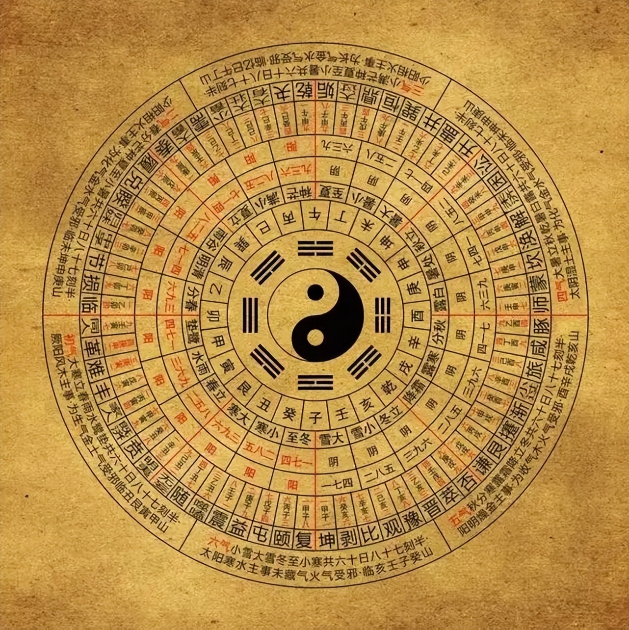
《易经》是中国汉族最古老的文献之一[1],并被儒家尊为“五经”之始;一般说上古三大奇书包括《黄帝内经》、《易经》、《山海经》,但它们成书都较晚。《易经》以一套符号系统来描述状态的简易、变易、不易,表现了中国古典文化的哲学和宇宙观。它的中心思想,是以阴阳的交替变化描述世间万物。《易经》最初用于占卜和预报天气,但它的影响遍及中国的哲学、宗教、医学、天文、算术、文学、音乐、艺术、军事和武术等各方面,是一部无所不包的巨著。自从17世纪开始,《易经》也被介绍到西方。在四库全书中为经部,十三经中未经秦始皇焚书之害,它是最早哲学书。自从十七世纪开始,《易经》也被介绍到西方。
《易》原有三种版本:《连山》、《归藏》和《周易》[2],《连山》和《归藏》已经失传,一般所称《易经》即源于《周易》发展而来。
《易经》包括狭义的《周易》与《易传》。《周易》相传是依循周文王主编《易》的著述而来,成书大约在西周时期。由于随时代演变,《周易》文字含义到了春秋战国时代已经不便读懂,因此孔子撰写了“十翼”,后世又称为《易传》并列入《易经》。
Das I Ging, hist. Romanisierung, heute: Yijing (chinesisch 易經 / 易经, Pinyin Yìjīng, W.-G. I-Ching ‚Buch der Wandlungen od. Klassiker der Wandlungen‘) ist eine Sammlung von Strichzeichen und zugeordneten Sprüchen. Es ist der älteste der klassischen chinesischen Texte. Seine legendäre Entstehungsgeschichte wird traditionell bis in das 3. Jahrtausend v. Chr. zurückgeführt. Das Werk ist im Chinesischen allgemein auch als Zhouyi (周易, Zhōuyì ‚Wandlungen der Zhou‘) bekannt.
『易経』(えききょう、正字体:易經、拼音: )は、古代中国の書物。『卜』が動物である亀の甲羅や牛や鹿の肩甲骨に入ったヒビの形から占うものであるのに対して、『筮』は植物である『蓍[1]』の茎の本数を用いた占いである。商の時代から蓄積された卜辞を集大成したものとして易経は成立した。易経は儒家である荀子の学派によって儒家の経典として取り込まれた。現代では、哲学書としての易経と占術のテキストとしての易経が、一部重なりながらも別のものとなっている。中心思想は、陰陽二つの元素の対立と統合により、森羅万象の変化法則を説く。著者は伏羲とされている[2]。
中国では『黄帝内經』・『山海經』と合わせて「上古三大奇書」とも呼ぶ。
The I Ching (/ˈiː ˈdʒɪŋ/),[2] also known as Classic of Changes or Book of Changes, is an ancient Chinese divination text and the oldest of the Chinese classics. Possessing a history of more than two and a half millennia of commentary and interpretation, the I Ching is an influential text read throughout the world, providing inspiration to the worlds of religion, psychoanalysis, literature, and art. Originally a divination manual in the Western Zhou period (1000–750 BC), over the course of the Warring States period and early imperial period (500–200 BC) it was transformed into a cosmological text with a series of philosophical commentaries known as the "Ten Wings".[3] After becoming part of the Five Classics in the 2nd century BC, the I Ching was the subject of scholarly commentary and the basis for divination practice for centuries across the Far East, and eventually took on an influential role in Western understanding of Eastern thought.
The I Ching uses a type of divination called cleromancy, which produces apparently random numbers. Six numbers between 6 and 9 are turned into a hexagram, which can then be looked up in the I Ching book, arranged in an order known as the King Wen sequence. The interpretation of the readings found in the I Ching is a matter of centuries of debate, and many commentators have used the book symbolically, often to provide guidance for moral decision making as informed by Taoism and Confucianism. The hexagrams themselves have often acquired cosmological significance and paralleled with many other traditional names for the processes of change such as yin and yang and Wu Xing.
Le Yi Jing (sinogrammes 易经simpl./易經trad., pinyin yì jīng, Wade-Giles i4 ching1, également orthographié Yi King ou Yi-King), prononcé en français i ting est un manuel chinois dont le titre peut se traduire par « Classique des changements » ou « Traité canonique des mutations ». Il s'agit d'un système de signes binaires qui peut être utilisé pour faire des divinations. Le Yi Jing s'appelle aussi Zhou Yi (周易, pinyin : Zhōu Yì, Wade-Giles : Chou1 I4) c'est-à-dire « changements de Zhou » pour la raison que son élaboration date du Ier millénaire avant l'ère chrétienne, époque des Zhou (1027, 256 av. J.-C.).
Il occupe une place fondamentale dans l'histoire de la pensée chinoise et peut être considéré comme un traité unique en son genre dont la finalité est de décrire les états du monde et leurs évolutions. Premier des cinq classiques, il est donc considéré comme le plus ancien texte chinois.
Le Yi Jing est le fruit d'une recherche spéculative et cosmogonique élaborée, dont les articulations ont influencé durablement la pensée chinoise. Sa structure mathématique a impressionné Leibniz qui y aurait vu la première formulation de l'arithmétique binaire. De fait, partant d'une opposition/complémentarité entre les principes d'engendrement Yin et Yang (yin // réceptif // lune // femelle // passif alors que yang // créatif // soleil // mâle // actif) et subdivisant cette dualité de façon systématique (adret = côté au Soleil alors qu'ubac = côté à l'ombre ; vents favorables opposés aux nuages contraires), le Yi Jing arrive à la série des 64 figures qui peuvent interpréter toutes les transformations possibles.
« Le Yi-King ou Livre des transformations de l'archaïque magie chinoise apporte l'image la plus exemplaire de l'identité du Génésique et du Génétique. La boucle circulaire est un cercle cosmogonique symboliquement tourbillonnaire par le S intérieur qui à la fois sépare et unit le Yin et le Yang. La figure se forme non à partir du centre mais de la périphérie et naît de la rencontre de mouvements de directions opposés. Le Yin et le Yang sont intimement épousés l'un dans l'autre, mais distincts, ils sont à la fois complémentaires, concurrents, antagonistes. La figure primordiale du Yi-King est donc une figure d'ordre, d'harmonie, mais portant en elle l'idée tourbillonnaire et le principe d'antagonisme. C'est une figure de complexité. »
— Edgar Morin, La Méthode 1. La Nature de la Nature, p. 228, Seuil, Paris, 1977.
Il Libro dei Mutamenti[2] (易經T, 易经S, YìjīngP, I ChingW[3]), conosciuto anche come Zhou Yi 周易 o I Mutamenti (della dinastia) Zhou, è ritenuto il primo dei testi classici cinesi sin da prima della nascita dell'impero cinese. È sopravvissuto alla distruzione delle biblioteche operata dal Primo imperatore, Qin Shi Huang Di.
L'Yi Jing è diviso in due porzioni, jing 經 o 'classico' e zhuan 傳 o 'commentario', composti in momenti differenti ma tramandati come testo unico da due millenni circa. La porzione jing è composta da sessantaquattro unità, ognuna basata su un esagramma (gua 卦) composto di sei linee che sono o continue (⚊) rappresentanti il principio yang o interrotte (⚋) rappresentanti il principio yin. Per ogni esagramma vi è una spiegazione chiamata 卦辞 guaci, accompagnata dalla spiegazione delle singole linee costituenti il trigramma chiamate 爻辞 yaoci. I primi due esagrammi del testo 乾 qian e 坤 kun sono accompagnati da due ulteriori testi chiamati 用六 yongliu e 用九 yongjiu.
Considerato da Confucio libro di saggezza, è utilizzato a livello popolare a scopo divinatorio, e dagli studiosi per approfondire aspetti matematici, filosofici e fisici. I metodi per ottenere i responsi sono vari e si passa dai gusci di tartaruga al lancio di 3 monete. Quando si utilizzano gli steli di achillea per estrarre i responsi, l'arte divinatoria è chiamata achilleomanzia.
El I Ching, Yijing o I King (en chino tradicional: 易經; en chino simplificado: 易经; en pinyin: yì jīng) es un libro oracular chino cuyos primeros textos se suponen escritos hacia el 1200 a. C. Es uno de los Cinco Clásicos confucianos.
El término i ching significa ‘libro de las mutaciones’. El texto fue aumentado durante la dinastía Zhou y posteriormente por comentaristas de la escuela de Confucio, pero su contenido original es de procedencia taoísta, y no confucianista. Se cree que describe la situación presente de quien lo consulta y predice el modo en que se resolverá en el futuro si se adopta ante ella la posición correcta. Es un libro adivinatorio y también un libro moral, a la vez que por su estructura y simbología es un libro filosófico y cosmogónico.
«И цзин» (кит. трад. 易經, упр. 易经, пиньинь: Yì Jīng), или «Чжоу И»[1] (周易) — наиболее ранний из китайских философских текстов. Наиболее ранний слой, традиционно датируемый ок. 700 г. до. н. э.[2] и предназначавшийся для гадания, состоит из 64 гексаграмм. Во II веке до н. э. был принят конфуцианской традицией как один из канонов конфуцианского Пятикнижия.
«Кни́га Переме́н» — название, закрепившееся за «И цзин» на Западе. Более правильный, хоть и не столь благозвучный вариант — «Кано́н Переме́н».
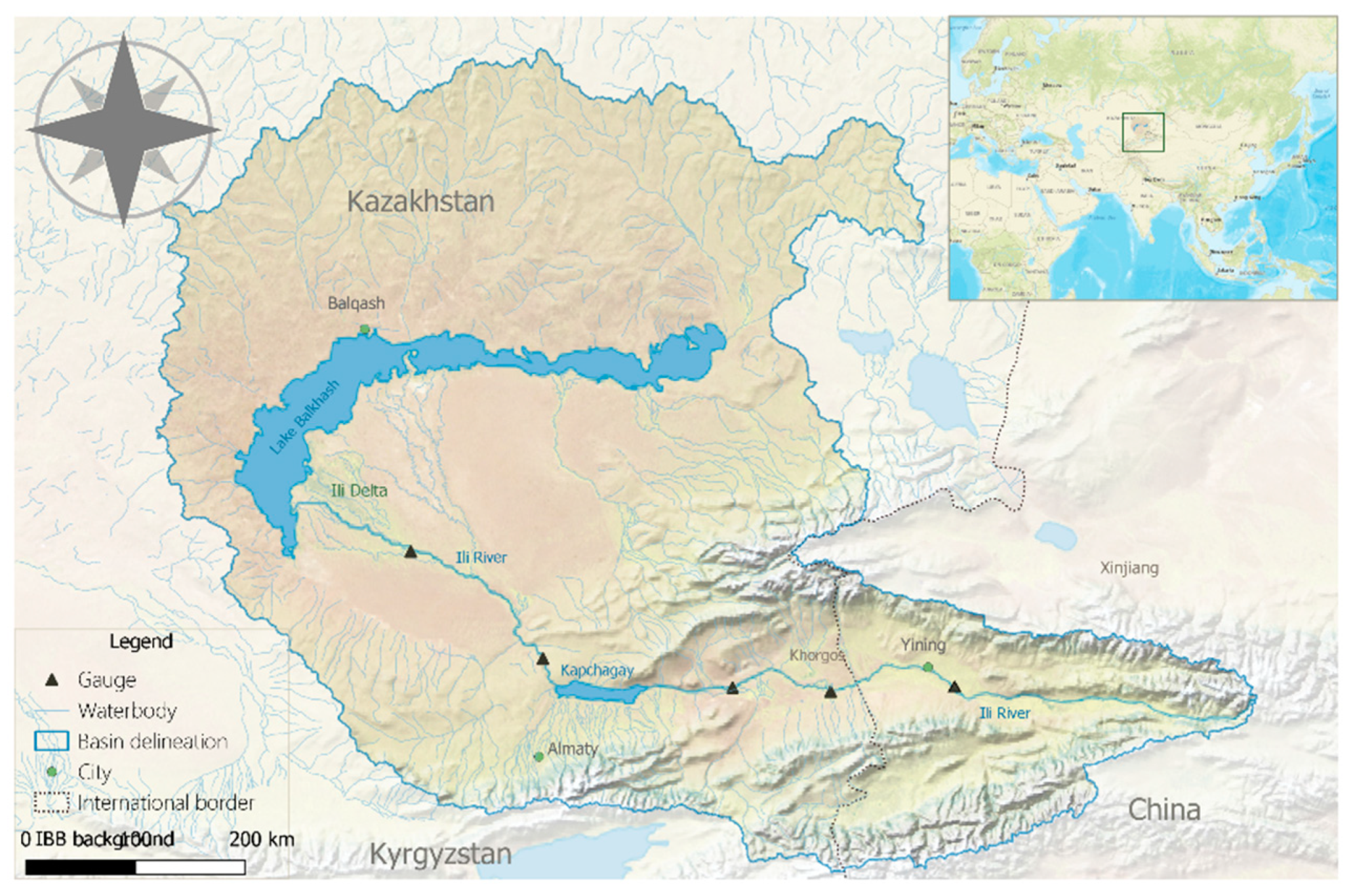
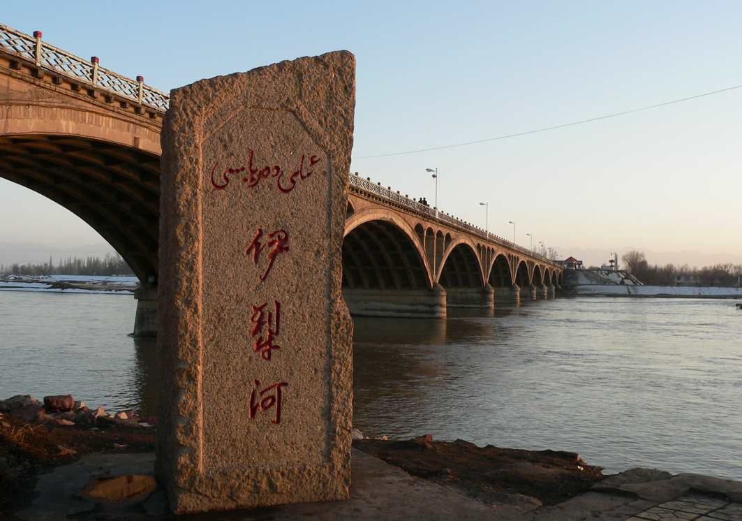
伊犁河(哈薩克語:ىلە وزەنى,西里尔字母:Іле өзені)是中国水量最大的内陆河,也是新疆水量最丰富的河流。
伊犁河主源特克斯河发源于汗腾格里峰北侧,由西向东流,在东经82°左右折向北流,穿过喀德明山脉,和巩乃斯河汇合,又折向西流,在伊宁和喀什河汇合,穿越国境,进入哈萨克斯坦,最终进入巴尔喀什湖。
伊犁河上游穿越一系列山地和谷地,这个区域年降水量达到700毫米,春季还有高山融雪水进入,因此水量丰富,年径流量为118亿立方米。过了伊宁后,进入河谷平原,河床变宽,多沙洲岛屿,水流分叉。
伊犁河流域气温比新疆其他地区高,干流封冻只有60天左右,由于上游主要是岩石高山,因此含沙量也少,年平均为0.2-0.5千克/立方米。
伊犁河流域因为雨水丰沛,农业几乎不需要灌溉。下游在5-10月间可通航吃水量为200吨左右的船只。

1947年印巴分治以前,印度河仅次于恒河,为该地区的文化和商业中心地带。该河流上源为狮泉河(森格藏布),它发源于冈底斯山脉冈仁波齐峰东北方向的切日阿弄拉山口西侧,源头位于中国西藏阿里地区革吉县境内,源头溪流名为邦果贡[1]。从喜马拉雅山脉朝西北方向流入克什米尔,调头向南流入巴基斯坦,在信德省的卡拉奇附近流进阿拉伯海。河流总长度3180公里,流域面积100万1549平方公里[1]。印度河文明为世界上最早进入农业文明和定居社会主要文明之一,后来因为约二百年的干旱而灭亡[2]。
印度河每年的流量约有207立方公里,是世界流量第二十一名的河流。赞斯卡河是位在拉达克的左岸支流,在进入平原后,印度河的左岸支流是潘季纳德河(五河),其五条主要支流分别是杰赫勒姆河、奇纳布河、拉维河、比亚斯河及萨特莱杰河。印度河的主要右岸支流有什约克河、吉尔吉特河、喀布尔河、库拉姆河及古马尔河及。印度河的沿岸有温带森林、平原及干旱乡村等不同的生态系统。
印度河形成了印度河三角洲,在古印度的《梨俱吠陀》中称为Sapta Sindhu,在伊朗人的波斯古经中称做Hapta Hindu,两者都是“七河”的意思。波斯王大流士曾在公元前510年派西拉克斯探索印度河。
The Indus River (called Sindhū in Sanskrit with derived names in most Indic languages)[1][2] is one of the longest rivers in Asia. It flows through China (western Tibet), India (Ladakh) and Pakistan.[3] Originating in the Tibetan Plateau in the vicinity of Lake Manasarovar, the river runs a course through the Ladakh region of India,[a] towards Gilgit-Baltistan and then flows in a southerly direction along the entire length of Pakistan to merge into the Arabian Sea near the port city of Karachi in Sindh.[4] It is the longest river of Pakistan.[5]
The river has a total drainage area exceeding 1,165,000 km2 (450,000 sq mi). Its estimated annual flow stands at around 243 km3 (58 cu mi), twice that of the Nile River and three times that of the Tigris and Euphrates rivers combined, making it one of the largest rivers in the world in terms of annual flow.[6] The Zanskar is its left bank tributary in Ladakh. In the plains, its left bank tributary is the Panjnad which itself has five major tributaries, namely, the Chenab, Jhelum, the Ravi, the Beas, and the Sutlej. Its principal right bank tributaries are the Shyok, the Gilgit, the Kabul, the Gomal, and the Kurram. Beginning in a mountain spring and fed with glaciers and rivers in the Himalayan, Karakoram and Hindu Kush ranges, the river supports ecosystems of temperate forests, plains and arid countryside.
The northern part of the Indus Valley, with its tributaries, forms the Punjab region, while the lower course of the river is known as Sindh and ends in a large delta. The river has historically been important to many cultures of the region. The 3rd millennium BC saw the rise of a major urban civilization of the Bronze Age. During the 2nd millennium BC, the Punjab region was mentioned in the hymns of the Hindu Rigveda as Sapta Sindhu and the Zoroastrian Avesta as Hapta Hindu (both terms meaning "seven rivers"). Early historical kingdoms that arose in the Indus Valley include Gandhāra, and the Ror dynasty of Sauvīra. The Indus River came into the knowledge of the West early in the Classical Period, when King Darius of Persia sent his Greek subject Scylax of Caryanda to explore the river, c. 515 BC.
L’Indus (connu sous le nom de Sindh ou Sindhu dans l’Antiquité, et de Senge Khabab en tibétain « qui sort de la bouche du lion » au niveau de sa source) est un fleuve d'Asie qui a donné son nom à l’Inde1. Il coule depuis l’Himalaya en direction du sud-ouest et se jette dans la mer d'Arabie. L’Indus fait partie des sept rivières sacrées de l'Inde.
L'Indo è il più lungo e importante fiume del Pakistan. È il più lungo fiume del subcontinente indiano e il terzo più grande dell'Asia intera in termini di portata annua.La sorgente dell'Indo si trova in Tibet tra monti Kailâs o Gangri. Il fiume prende il suo nome a partire dalla confluenza dei torrenti Sengge e Gar, che scendono dall'Himalaya raccogliendo le acque delle catene del Nganglong Kangri e del Gangdise Shan. L'Indo passa in seguito verso nord-ovest attraverso il Kashmir, a sud della catena del Karakorum, poi gradualmente gira verso sud, lasciando le colline tra Peshawar e Rawalpindi. In quest'area una diga forma il lago artificiale di Tarbela. A partire dalla sua confluenza con il fiume Kaboul, l'Indo diventa navigabile.
Il resto del suo tragitto verso il mare si svolge quindi nelle pianure del Panjab e del Sindh, e il fiume prende allora un corso molto lento. Attraversa Hyderabad poi si getta nel mare Arabico con un grande delta di 7770 km² che si estende su 200 km di costa, a sud-est di Karachi, ora considerata come una delle regioni ecologiche più importanti del mondo.El río Indo es un río asiático que discurre por el subcontinente indio, uno de los más largos del continente, el más importante de Pakistán y de los principales de la India (y que también recorre en su curso alto China). Originario de la meseta tibetana del oeste de China, en la Región Autónoma del Tíbet, el río discurre a través del distrito de Ladakh de Jammu y Cachemira y luego entra en Pakistán a través de Gilgit-Baltistán; sigue después desde el norte del país en dirección sur cruzando a lo largo todo Pakistán, hasta desembocar en el mar Arábigo, cerca de la ciudad portuaria de Karachi en Sind.
La longitud total del río es de 3.180 km, siendo el río más largo de Pakistán. Drena una gran cuenca de más de 1.165.000 km² y tiene un caudal anual estimado en unos 207 km³, lo que lo convierten en el 21º más caudaloso del mundo. Comenzando en las alturas del mundo con glaciares, el río alimenta el ecosistema de los bosques templados, llanuras y paisajes áridos. Junto con los ríos Jhelum, Chenab, Ravi, Sutlej, Beas y dos afluentes desde la Jaiber Pajtunjuá y Afganistán, el Indo forma el delta del Indo de Pakistán, mencionado en el Rig-veda (el texto más antiguo de la India, de mediados del II milenio a. C.) como Sapta Sindhu y en el texto iranio Zend Avesta como Hapta Hindu (significando ambos términos, ‘siete ríos’).
El río Indo proporciona los recursos hídricos clave para la economía de Pakistán —especialmente el granero de la provincia de Panyab, que representa la mayor parte de la producción agrícola de la nación, y de Sindh. El Indo también soporta muchas industrias pesadas y constituye el principal suministro de agua potable en Pakistán. Los cinco ríos que dan nombre al Panyab son el Jhelum, Chenab, el Ravi, el Beas y el Sutlej.
Antes de la división en 1947 de la antigua India en los modernos estados de la India y Pakistán, el Indo era el segundo río en importancia de la región, después del río Ganges, tanto en términos culturales como comerciales. En la actualidad el río también da nombre a la provincia pakistaní de Sind.
El río ha sido una fuente de asombro durante el periodo clásico. El rey Darío I de Persia envió a Escílax de Carianda a explorar el Indo entre los años 519 y 512 a. C., descendiéndolo hasta llegar al mar. Llamado Hindós o Indós por los griegos y luego Indus por los autores latinos, fue siempre conocido en Occidente por su nombre latinizado que también dio nombre a la India (Bharat).
Инд (тиб. སེང་གེ།་གཙང་པོ Sênggê Zangbo, кит. 印度河 Yìndù Hé, хинди सिन्धु नदी, з.-пандж. دریاۓ سندھ Sindh, пушту اباسين Abāsin, синдхи سنڌوندي Sindhu, урду دریائے سندھ) — крупная река в Южной Азии, берёт начало на территории Китая в Гималаях и протекает большей частью по территории северо-западной Индии и Пакистана. Исток находится на Тибетском нагорье, устье — на севере Аравийского моря[1], недалеко от города Карачи. Длина Инда — 3180 км, площадь бассейна 960 000[2] км². (980 тыс. км² в БСЭ[3]). Средний расход воды — 6600 м³/с.[источник не указан 1256 дней]
Названия: санскр. सिन्धु (Sindhu IAST); урду سندھ (Sindh); синдхи سندھو (Sindhu); в.-пандж. سندھ (Sindh IAST); авест. Hindu; пушту اباسين (Абба-Син «отец рек»); перс. هند («Hind»); тиб. སེངགེ་ཆུ («Lion River»); кит. упр. 印度河, пиньинь Yìndù Hé; греч. Ινδός (Индос).
Инд (Синдху) — одна из главных рек ведийского Семиречья.
Beijing Shi-BJ
China
 Finanz
Guangdong Sheng-GD
Hongkong Tebiexingzhengqu-HK
Shanghai Shi-SH
Finanz
Guangdong Sheng-GD
Hongkong Tebiexingzhengqu-HK
Shanghai Shi-SH
 Unternehmen
*Größte Banken
Unternehmen
*Größte Banken
 Wirtschaft und Handel