
漢德百科全書 | 汉德百科全书
 Sichuan Sheng-SC
 Bildung und Forschung


 Geographie
China
Chongqing Shi-CQ
Gansu Sheng-GS
Henan Sheng-HA
Hubei Sheng-HB
Geographie
China
Chongqing Shi-CQ
Gansu Sheng-GS
Henan Sheng-HA
Hubei Sheng-HB
 Rueckblick
Shaanxi Sheng-SN
Sichuan Sheng-SC
Rueckblick
Shaanxi Sheng-SN
Sichuan Sheng-SC

Der Qin-Ling (chinesisch 秦嶺 / 秦岭, Pinyin Qín Lǐng), auch Qin-Ling-Gebirgszug (秦嶺山脈 / 秦岭山脉, Qín Lǐng Shānmài) genannt, geografisch in der Mitte der Volksrepublik China, erstreckt sich in West-Ost-Richtung über etwa 1000 km Länge[1] (bei einer Breite von bis zu 170 km) vom Süden der Provinz Gansu über den gesamten Süden der Provinz Shaanxi bis zum zentralen Teil der Provinz Henan.
Der Taibai Shan ist mit 3767 m der höchste Berg des Qin Ling. Im Norden wird das Gebirge vom Wei-Fluss und im Süden vom Fluss Han Jiang begrenzt. Diese beiden Flüsse entwässern in die beiden großen chinesischen Ströme.
Das Gebirge bildet dadurch nicht nur eine Wasserscheide zwischen den Fluss-Systemen des Gelben Flusses und des Jangtsekiang, sondern auch eine markante Vegetationsgrenze. Während nördlich des Gebirgszuges trockene Lößregionen vorherrschen, die ideal für den Weizenanbau geeignet sind, beginnen südlich des Qin Ling die wärmeren, feuchteren Landstriche, in denen sich ausgedehnte Waldregionen mit Reisfeldern abwechseln.
秦岭是横贯中国中部的一座褶皱山脉,西起甘肃临洮,东到河南省的崤山、熊耳山-嵩山和伏牛山地区,主体位于陕西省中南部,是陕西省关中地区与陕南地区的分界线,呈东西走向,长1600公里。宽200~300公里,海拔2000~3000米。
秦岭-淮河线是中国地理上的南北分界线,秦岭同时也是长江流域与黄河流域的一个分水岭。狭义的秦岭是秦岭山脉的陕西段。位于秦岭山脉北面的关中平原为春秋战国时秦国的领地,在汉代即有“秦岭”之名;又因位于关中以南,故名“南山”。[1]
秦嶺山脈(しんれいさんみゃく)は、中国中部を東西に貫く山脈。黄河と揚子江を中流域で分けている。名前の由来は二千年前の秦の国にある山脈、秦嶺と称する。別名崑崙である。中国語でチンリンシャンマイ(Qínlǐng Shānmài)、英語でQinling Mountains。
古代中国に崑崙と呼ぶ。天下の龍脈の根と称する。唐以後の崑崙は現崑崙山脈である。唐の時代、古代アラビア人から販売された黒人たちを崑崙奴と言う。
西は甘粛省東部から東は河南省西部に及ぶ。平均海抜は2,000-3,000メートルであり、最高峰である太白山の海抜は3,767メートル。陝西省武功県から藍田県にわたる部分を終南山という。
トキ、ジャイアントパンダ、キンシコウなど、独特の稀少動物が生息し、ヤクタネゴヨウマツなどの独特の植物や、野生のキウイフルーツ、カホクザンショウなども見られる。
The Qinling (Chinese: 秦岭) or Qin Mountains, formerly known as the Nanshan ("Southern Mountains") and sometimes called the "Szechuan Alps", are a major east-west mountain range in southern Shaanxi Province, China. The mountains mark the divide between the drainage basins of the Yangtze and Yellow River systems, providing a natural boundary between North and South China and support a huge variety of plant and wildlife, some of which is found nowhere else on earth.
To the north is the densely populated Wei River valley, an ancient center of Chinese civilization. To the south is the Han River valley. To the west is the line of mountains along the northern edge of the Tibetan Plateau. To the east are the lower Funiu and Dabie Shan which rise out of the coastal plain.
The northern side of the range is prone to hot weather, however the physical barrier of the mountains mean that the land to the North has a semi-arid climate, with the lack of rich, fertile landscape that can not support a wealth of wildlife.[1] The mountains also acted as a natural defense against nomadic invasions from the North, as only four passes cross the mountains. In the late 1990s a railway tunnel and a spiral was completed, thereby easing travel across the range.[2]
The highest mountain in the range is Mount Taibai at 3,767 meters (12,359 ft), which is about 100 kilometers (62 mi) west of the ancient Chinese capital of Xi'an.[3] Three culturally significant peaks in the range are Mount Hua (2,155 meters or 7,070 feet), Mount Li (1,302 meters or 4,272 feet), and Mount Maiji (1,742 meters or 5,715 feet).
Les monts Qinling (chinois simplifié : 秦岭 ; chinois traditionnel : 秦嶺 ; pinyin : ; litt. « Cordillère des frênes ») sont une importante chaîne de montagnes de la Chine centrale, qui s'étend d'est en ouest sur près de 1 500 km.
Ils forment la principale barrière physique entre la vallée de la rivière Wei (affluent principal du fleuve Jaune) au nord et la plaine du Sichuan au sud ; ils constituent également la limite sud du plateau de Lœss. Leur plus haut sommet est le pic Taibai (3 767 m).
Ils sont le refuge d'espèces animales rares, en particulier du panda de Qinling, la seule sous-espèce de pandas reconnue.
I monti Qin (cinese: 秦岭; pinyin: Qin Ling; romanizzazione Wade-Giles: Ch'in Ling), noti anche come monti Tsinling, sono una catena montuosa della Cina settentrionale, estesa lungo un asse ovest-est dalla provincia del Gansu sud-orientale fino alle province di Shaanxi ed Henan. Considerati un'estensione orientale dei monti Kunlun, costituiscono uno spartiacque tra il fiume Wei a nord e il fiume Han a sud e culminano a 3767 m con il monte Taibai. La catena forma una netta divisione fisica, sia climatica che topografica, separando la zona subtropicale monsonica delle verdi colline ricoperte di foreste a sud dalle zone temperato-calde di aride distese di loess a nord. Questa divisione si prolunga verso est lungo i monti Dabie e il fiume Huai nella provincia dello Anhui.
Las montañas Qín (en chino tradicional, 秦嶺; en chino simplificado, 秦 岭; pinyin, Qinling) es una cadena montañosa del Asia Central, la mayor cordillera al sureste de la provincia de Shaanxi, República Popular China. La cordillera forma una frontera natural entre el norte y el sur del país. Su flora y fauna es muy variada y algunas especies no se encuentran en otro lugar de la tierra.
Al norte está el densamente poblado valle del río Wei, cuna de la antigua civilización china; al sur, el valle del río Han; al oeste, se encuentra la meseta Tibetana; y al este la cordillera pierde progresivamente altura.
El norte de la cordillera es propenso al clima cálido, sin embargo, la barrera física de las montañas significa que la tierra al norte goza de un clima semiárido, con la falta de un paisaje rico y fértil no puede sustentar una amplia variedad de vida silvestre.
Las montañas también actuaron como una defensa natural contra las invasiones nómadas del norte. A finales de 1990 se completóun túnel ferroviario, facilitando así los viajes en toda la cordillera.
La montaña más alta de la cordillera es el monte Taibai (太白 山) de 3.767 m, que está a 100 km de la ciudad capital Xi'an. Y la montaña más alta del este de China, el monte Hua (华山) de 2.155 m, también está en esta cordillera.
En ellas viven los pandas de Qinling, una subespecie de oso panda con las mismas manchas pero en tonos beige y marrón en vez de blanco y negro, además de un tamaño algo menor.
Циньли́н[1] (кит. трад. 秦嶺, упр. 秦岭, пиньинь Qin Ling) — горный хребет в Восточной Азии, расположен на территории Китая. Является восточным продолжением хребта Куньлунь. Тянется с запада на восток на 1000 км от юго-запада провинции Ганьсу в провинции Шэньси и Хэнань. Самая высокая точка — гора Тайбайшань (высота 3767 м).[2] Кроме того, вершиной хребта является одна из священных гор даосизма — Хуашань.
По хребту проходит водораздел бассейнов главных рек Китая — Хуанхэ и Янцзы. Протекающая с севера от хребта река Вэйхэ отделяет Циньлин от Лёссового плато, а долина реки Ханьшуй с юга — от хребтов Мицаншань и Бадашань, за которыми лежит Сычуаньская котловина. Хребет состоит преимущественно из известняка и метаморфических сланцев. Западная часть прорезана глубокими ущельями, восточная состоит из четырёх отдельных отрогов. Имеется месторождение молибденовых руд.[3]
*Changjiang|Yangtze Fluß
*Changjiang|Yangtze Fluß
*Gelbe Fluss
*Gelbe Fluss
 Afghanistan
Bhutan
China
Gansu Sheng-GS
Indien
Kirgisistan
Nepal
Pakistan
Qinghai Sheng-QH
Sichuan Sheng-SC
Tadschikistan
Xinjiang Uygur Zizhiqu-XJ
Xizang Zizhiqu-XZ
Yunnan Sheng-YN
Afghanistan
Bhutan
China
Gansu Sheng-GS
Indien
Kirgisistan
Nepal
Pakistan
Qinghai Sheng-QH
Sichuan Sheng-SC
Tadschikistan
Xinjiang Uygur Zizhiqu-XJ
Xizang Zizhiqu-XZ
Yunnan Sheng-YN
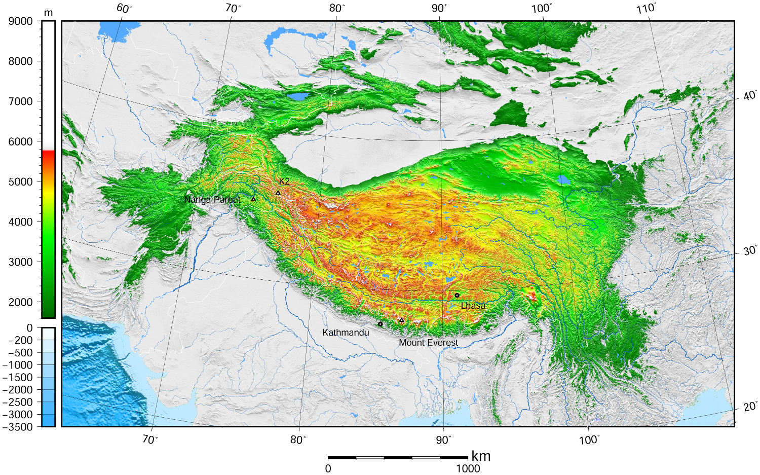
Das geographisch definierte Hochland von Tibet bzw. offiziell Qinghai-Tibet-Hochebene (chinesisch 青藏高原, Pinyin Qīng-Zàng gāoyuán), auch Hochasien, umfasst nicht nur den gesamten Lebensraum tibetisch-sprachiger Völkerschaften, das noch kleinere historische Tibet oder das heutige Autonome Gebiet Tibet (AGT) der Volksrepublik China, sondern auch die es eingrenzenden Hochgebirge Himalaya, Kunlun Shan, Qilian Shan usw.
Nachdem die Hochebene im frühen Miozän entstand, erreichte es die heutige Höhe vor etwa acht Millionen Jahren. Mit der Zeit schürften Erosion und Wetter Täler und bildeten Steilwände und Klippen.
Das Hochland, das etwa 4000 bis 5500 Meter Höhe über dem Meeresspiegel liegt und rund 2 Millionen km² groß ist, wird im Norden von den Wüsten des Tarimbeckens und Qaidam-Beckens begrenzt, im Süden und Westen von den Gebirgen Himalaya, Karakorum und Pamir. Obwohl der höchste Gipfel nur 7010 Meter hoch ist, ist die Ebene das höchste Plateau der Welt. Hier finden sich zahlreiche Salzseen in den Schluchten wie den Tilicho Lake, der auf 4920 Metern liegt und damit einer der höchstgelegenen Seen der Welt ist, des Weiteren weite Steppen, dichte Wälder und Wüsten. Diese Naturräume bieten vielen Tieren – darunter auch gefährdeten – Schutz, so etwa Yaks, Saigaantilopen, Asiatischen Schwarzbären, Schafen und Kiangs.
Zum Hochland von Tibet zählen demgemäß auch die Gebiete Ladakh, Zanskar, Lahaul und Spiti, Nord-Sikkim und weite Teile von Arunachal Pradesh in Nordindien, wie auch große Teile Bhutans und der Norden Nepals. Innerhalb der Volksrepublik China sind neben dem Autonomen Gebiet Tibet auch die gesamte Provinz Qinghai, der Südwesten von Gansu sowie Randbereiche des Nordwestens dieser Provinz, der Westen Sichuans und der Nordwesten Yunnans Teil des Hochlands, während das Aksai Chin im fernen Westen des Plateaus im Autonomen Gebiet Xinjiang in den Pamir überleitet.
青藏高原,是东亚一个高原地区,它是世界上最高的高原,平均海拔高度5900米(5800~6000米),面积250万平方公里,有“世界屋脊”,“雪域高原”,和“第三极”之称。它是在中亚[1][2][3][4]和西亚[5][6][7][8]的一个巨大的高原,大部分在中国西部的西藏自治区和青海省,以及在印度查谟-克什米尔邦拉达克的一部分。 它从南向北延伸约1,000千米(620英里),从东到西延伸约2,500千米(1,600英里)。中国境内之青藏高原,占全中国23%面积,位于北纬25°-40°和东经74°-104°之间。
高原边界,东为横断山脉,南、西为喜马拉雅山脉,北为昆仑山脉。涵盖国境有中国西藏自治区、青海省全境、新疆维吾尔自治区、甘肃省、四川省、云南省部分,以及不丹、尼泊尔、印度的拉达克等地。
チベット高原(チベットこうげん、中国語: 青藏高原、雪域高原)はユーラシア大陸の中央部に広がる世界最大級の高原。チベットの領域とほぼ等しい。 東西約2,000キロメートル、南北約1,200キロメートル、面積約250万平方キロメートル(日本の国土面積の約6倍)。高度は3,500から5,500メートル、平均4,500メートル。
南境にはヒマラヤ山脈、西境にはカラコルム山脈、北境には崑崙山脈・阿爾金山脈・祁連山脈、東境には横断山脈(邛崍山脈)が走り、7,000から8,000メートル級の高峰が連なる。東北部には面積20万平方キロメートルのツァイダム盆地やティショルギャルモ湖(青海湖)がある。
20世紀後半からこの高原の大部分を領有している中華人民共和国は西蔵・青海などの諸地方に区分して、両地方の略称「青」「藏」をあわせた青藏高原(拼音: せいぞうこうげん)としている。この高原は現在の中国領土の約23パーセントの面積を占めている。
また、チベット亡命政府が領有を主張している地域ともほぼ一致する。
The Tibetan Plateau (Tibetan: བོད་ས་མཐོ།, Wylie: bod sa mtho), also known in China as the Qinghai–Tibet Plateau[1] or the Qing–Zang Plateau[2] (Chinese: 青藏高原; pinyin: Qīng–Zàng Gāoyuán) or Himalayan Plateau, is a vast elevated plateau in Central Asia[3][4][5][6] and East Asia,[7][8][9][10] covering most of the Tibet Autonomous Region and Qinghai in western China, as well as Ladakh (Jammu and Kashmir) and Lahaul & Spiti (Himachal Pradesh) in India. It stretches approximately 1,000 kilometres (620 mi) north to south and 2,500 kilometres (1,600 mi) east to west. With an average elevation exceeding 4,500 metres (14,800 ft), the Tibetan Plateau is sometimes called "the Roof of the World" because it stands over 3 miles (4.8 km) above sea level and is surrounded by imposing mountain ranges that harbor the world's two highest summits, Mount Everest and K2, and is the world's highest and largest plateau, with an area of 2,500,000 square kilometres (970,000 sq mi) (about five times the size of Metropolitan France).[11] Sometimes termed the Third Pole, the Tibetan Plateau contains the headwaters of the drainage basins of most of the streams in surrounding regions. Its tens of thousands of glaciers and other geographical and ecological features serve as a "water tower" storing water and maintaining flow. The impact of global warming on the Tibetan Plateau is of intense scientific interest.[12][13][14][15]
Le plateau tibétain est un vaste ensemble de plateaux situé en Asie centrale, au nord de l'Himalaya, dont la majeure partie est située en République populaire de Chine et quelques parties le sont en Birmanie, au Bhoutan, au Népal et en Inde. Il a été créé par la collision des plaques indienne et eurasienne qui ont pris en étau les plaques de Qiantang et de Lhassa au cours du Cénozoïque. Constituant une des plus grandes structures topographiques de la Terre, il a d'importants effets climatiques régionaux (aridité du plateau lui-même, mousson) et mondiaux (circulation atmosphérique mondiale). Le nord-ouest du plateau, le Changtang, en est la région la plus élevée. D'une altitude dépassant souvent 5 000 m, il est pratiquement inhabité.
L'altopiano del Tibet (བོད་ས་མཐོ་) è un vasto ed elevato altopiano dell'Asia centrale che copre la maggior parte della regione autonoma del Tibet e della provincia del Qinghai in Cina e parte del Ladakh, nel Kashmir indiano.[1][2][3][4]
Occupa una superficie che si estende per 2.500 km di lunghezza e per 1.000 di larghezza, ad un'altitudine media di oltre 4.500 m s.l.m.[5][6][7] Talvolta chiamato il tetto del mondo, è l'altopiano più alto e più vasto del mondo, con una superficie di 1,2 milioni di chilometri quadrati (circa due volte la dimensione del Texas o della Francia, più di quattro volte l'Italia).[8]
L'altopiano tibetano è circondato da alte catene montuose: è delimitato a nord-ovest dai monti Kunlun che lo separano dal bacino del Tarim, e a nord-est dalla catena dei Qilian Shan che lo separa dal Corridoio di Hexi e dal deserto del Gobi. I suoi confini meridionali sono disegnati dalla valle del fiume Brahmaputra (Yǎlǔ Zàngbù Jiāng) che corre lungo la base dell'Himalaya. A occidente l'altopiano è abbracciato dalla robusta catena del Karakoram nel Kashmir settentrionale. A est e sud-est l'altopiano cede il passo alle gole boscose dei fiumi Salween, Mekong, Fiume Azzurro, alle regioni occidentali del Sichuan e sud-occidentali del Qinghai.
La meseta del Tíbet, también conocida como la meseta Tibetana-Qinghai, es una extensa y elevada meseta de Asia oriental que ocupa gran parte de la Región Autónoma del Tíbet y de la provincia de Qinghai, en la República Popular China, y de la región india de Ladakh, en Cachemira. Ocupa un área rectangular aproximada de 1.000 km de ancho por 2.500 km de largo, y tiene una elevación media de 4.500 metros. Es llamada "el techo del mundo", pues es la meseta más alta y grande del mundo, con un área de 2,5 millones de kilómetros cuadrados de extensión (cerca del tamaño de la República Argentina y cuatro veces el tamaño de Texas o Francia)
La meseta tibetana está rodeada por cadenas de montañas elevadas.1 Limita al noroeste con la cordillera Kunlun, que la separa de la cuenca del Tarim, y al noreste con las montañas Qilian, que separa la meseta del desierto de Gobi. La meseta limita al sur con el valle del río Yarlung Tsangpo, que fluye a lo largo del pie del Himalaya, y por la extensa Llanura indogangética. Al este y sureste, la meseta da paso a la geografía arbolada y abrupta de montaña de los nacimientos de los ríos Saluin, Mekong y Yangtsé, en la zona occidental de Sichuan. En el oeste está rodeada por la curva de la abrupta cordillera de Karakoram del norte de Cachemira.
Тибе́тское наго́рье — самое большое по площади и высочайшее нагорье мира[1],имеющее площадь около 2,5 млн кв. км, среднюю высоту 4877 м. Протяжённость с запада на восток 2500 км, с юга на север 1000 км[2]. Очень разнообразно по рельефу, растительности и животному миру. Посещаемости туристов способствует известность Тибета как обители буддийских монахов, святых (махатм).
Территория богата полезными ископаемыми, включая золото, что по некоторым сведениям и спровоцировало захват Тибета Китайской Народной Республикой в 1951 году, и последущее разграбление богатств страны[3] (Китай также получил контроль над источниками почти всех больших рек Азии).
Нагорье с севера ограничено хребтом Куньлунь, с северо-востока — системой хребтов Циляньшань, отделяющим его от пустыни Гоби. В Тибетском нагорье начинаются крупнейшие реки Инд, Брахмапутра, Салуин, Меконг, Янцзы, Хуанхэ. На западе нагорье граничит с хребтами Памира, на востоке с Сино-Тибетскими горами[4].
 Religion
 Weltkulturerbe

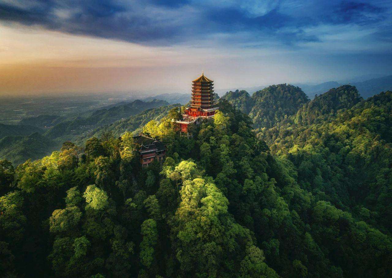

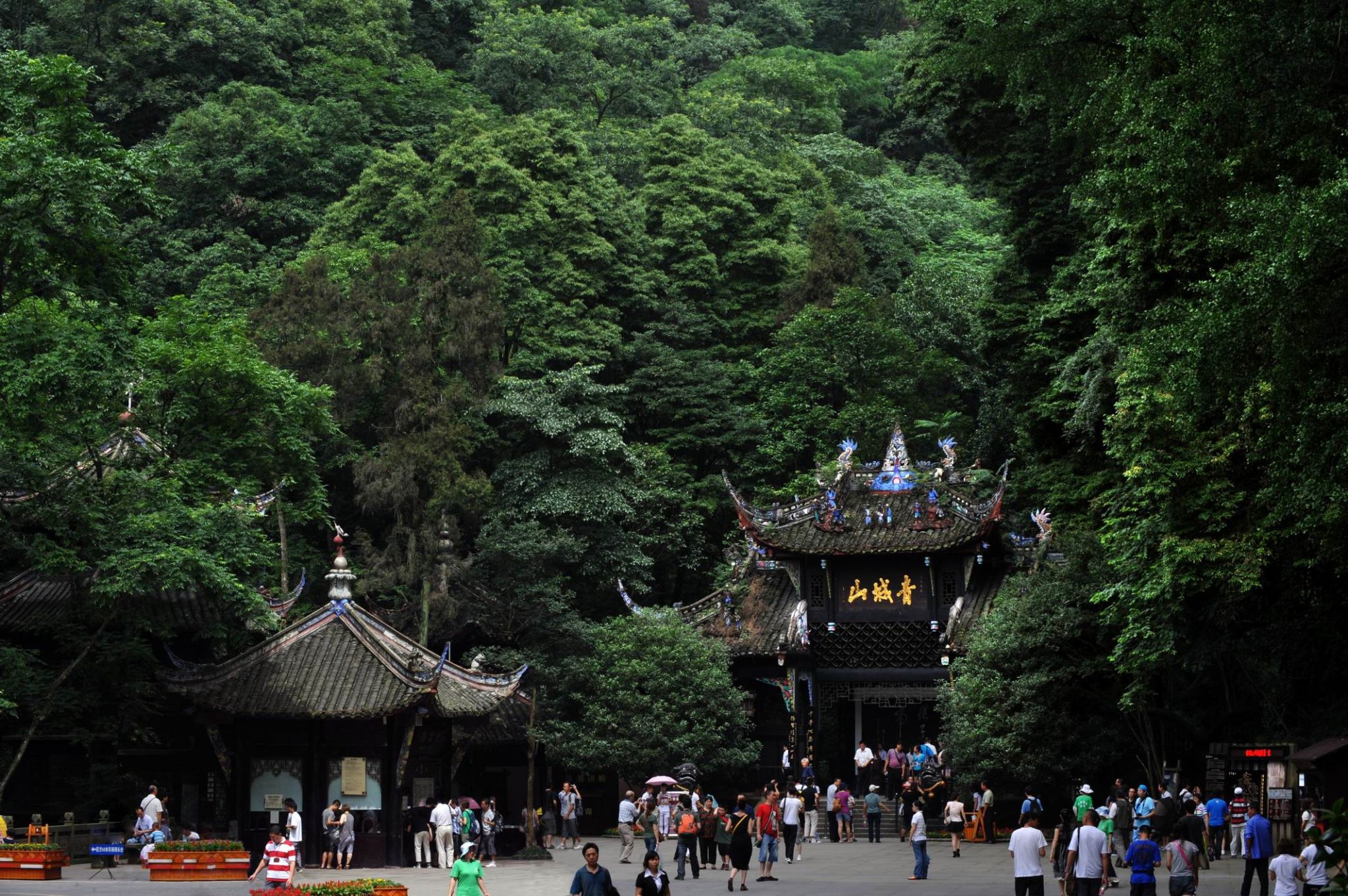
Für einen Tagesausflug ab Chengdu bietet der bis 1600 m hohe Qingcheng Shan die ideale Kombination mit Dujiangyan: Nur 15 km weiter westlich gelegen, ist dies einer der bedeutenderen taoistischen Klosterberge Chinas, und mit seinen Felsen, Grotten, Wasserfällen und dichten Wäldern sieht er aus wie aus dem Bilderbuch – ein Grund, weswegen er zum Unesco Welterbe zählt. Der „Himmelsmeister“ Zhongdaoling (34-156), der den Taoismus entscheidend prägte, soll hier eine Zeit lang gewirkt haben, ehe er als Unsterblicher zum Himmel aufstieg. Heute schafft man Ähnliches per Sessellift – wenn auch nur ein Stück weit. Vom Besuch des Qing Cheng Shan am Wochenende ist abzuraten.(Quelle:http://www.chinareiseexperte.de/chengdu-qingchengshan-berg.htm)
Der Qingcheng Shan (chinesisch 青城山, Pinyin Qīngchéng Shān), auch Berg Qingcheng, ist ein Berg auf dem Gebiet von Dujiangyan in der chinesischen Provinz Sichuan. Er ist eine bedeutende Stätte des religiösen Daoismus und einer seiner Entstehungsorte. Es befinden sich viele daoistische Tempel auf dem Berg. Als einer der Gründungsorte des Daoismus wurde der Berg mit seinen Tempeln im Jahr 2000 in die Liste des UNESCO-Welterbes aufgenommen.[1]
Im Tempel Changdao Guan (青城山常道观) praktizierte Zhang Daoling 张道陵. Der Tempel wird deshalb auch die Himmelsmeister-Grotte (Tianshidong 天师洞) genannt und steht in der Tradition der Quanzhen-Schule des Daoismus.
青城山为中国道教发源地之一,属道教名山之一。位于四川省都江堰市西南,古称“可韩山”、“丈人山”,东距成都市68公里,处于都江堰水利工程西南10公里处。主峰老霄顶海拔1600米。在四川名山中与剑门之险、峨嵋之秀、夔门之雄齐名,有“青城天下幽”之美誉。青城山是著名的中国历史名山和国家重点风景名胜区,并于2000年同都江堰共同作为一项世界文化遗产被列入世界遗产名录。2008年汶川地震中青城山受到比较大的影响。
青城山(せいじょうさん、拼音: )は、中国四川省都江堰市にある山地・景勝地。道教の発祥の地の一つとして古代より知られ、道教関係の重要な建築物が集中し、宗教・医療・音楽などの道教文化が伝えられてきた。中国の中でも著名な歴史名山および国家重点風景名勝区であり、2000年、付近の岷江にある古代の水利施設の都江堰(とこうえん)とともに世界遺産(文化遺産)に登録されている。
Mount Qingcheng (Chinese: 青城山; pinyin: Qīngchéng Shān) is a mountain in Dujiangyan, Sichuan, China. It is considered one of the birthplaces of Taoism (Daoism) and one of the most important Taoist centres in China. In Taoist mythology, it was the site of the Yellow Emperor's studies with Ning Fengzi. As a centre of the Taoist religion it became host to many temples. The mountain has 36 peaks. It is home to Dujiangyan Giant Panda Center and is a UNESCO World Heritage Site. Mount Qingcheng was affected by the Wenchuan Earthquake in 2008.[1][2]
Le mont Qingcheng (sinogrammes : 青城山 ; pinyin : Qīngchéng Shān ; littéralement : « mont de la cité d'azur ») ou Qingcheng Shan est une montagne sacrée taoïste située dans la province chinoise du Sichuan.
Dans la mythologie taoïste, c'est là que l'Empereur Jaune reçut l'enseignement de Ning Fengzhi. La montagne abrite de nombreux temples taoïstes, le mieux préservé étant le temple Jianfu (Jiànfú Gōng), qui accueille encore une centaine de moines, alors qu'il en accueillait 500 avant la Révolution culturelle1.
Conjointement au système d'irrigation de Dujiangyan, il a été inscrit sur la liste du patrimoine mondial de l'UNESCO en 2000.
Il Monte Qingcheng (in cinese: 青城山, Qīngchēng Shān) è una montagna che si trova nella provincia di Sichuan, in Cina. Secondo la mitologia taoista, qui l'Imperatore Giallo studiò con Ning Fengzhi. Nel corso dei secoli su questo monte vennero eretti numerosi templi di questa religione.
Insieme al sistema di irrigazione del Dujiangyan, nel 2000 il monte Qincheng è stato inserito nell'elenco dei Patrimoni dell'umanità dell'UNESCO.
El monte Qingcheng (en chino, 青城山; pinyin, Qīngchéng Shān) es una montaña de Guanxian, provincia de Sichuan, China. En la mitología taoísta, este era el lugar donde el Emperador Amarillo estudió con Ning Fengzhi. Como un centro de la religión taoísta, se hicieron multitud de templos. La montaña tiene 36 picos. En esta montaña se localizó el epicentro del terremoto de 12 de mayo de 2008.
Junto al sistema de irrigación de Dujiangyan forma parte del Patrimonio de la Humanidad desde 2000.
Цинчэнша́нь (кит. упр. 青城山, пиньинь Qīngchéng Shān) — гора в городском уезде Дуцзянъянь, 68 км от Чэнду, китайская провинция Сычуань. К югу от этих гор находится гора Хэминшань, где патриарх Чжан Даолин в 142 году встретился с Лао-цзы. Название означает "Гора голубой крепости".
На горе Цинчэншань в 143 году Чжан Даолин основал первый в истории даосский храмовый комплекс, тем самым превратив даосизм из философского в религиозное учение. С этой горы, согласно традиции, Чжан Даолин ушёл на небо с женой и двумя учениками.
Во времена династии Тан на склонах горы помещалось не менее 70 даосских обителей.
На начало XX века в них жило ок. 500 монахов. Коммунистические власти закрыли большую часть монастырей, однако приблизительно сотня отшельников продолжала на горе вековые даосские традиции. В начале 80х годов XX века большинство монастырей официально были открыты с финансовой поддержкой современных властей. В 2000 г. священная гора Цинчэн занесена ЮНЕСКО в список объектов Всемирного наследия.
 Geschichte
 Kunst
Kunst
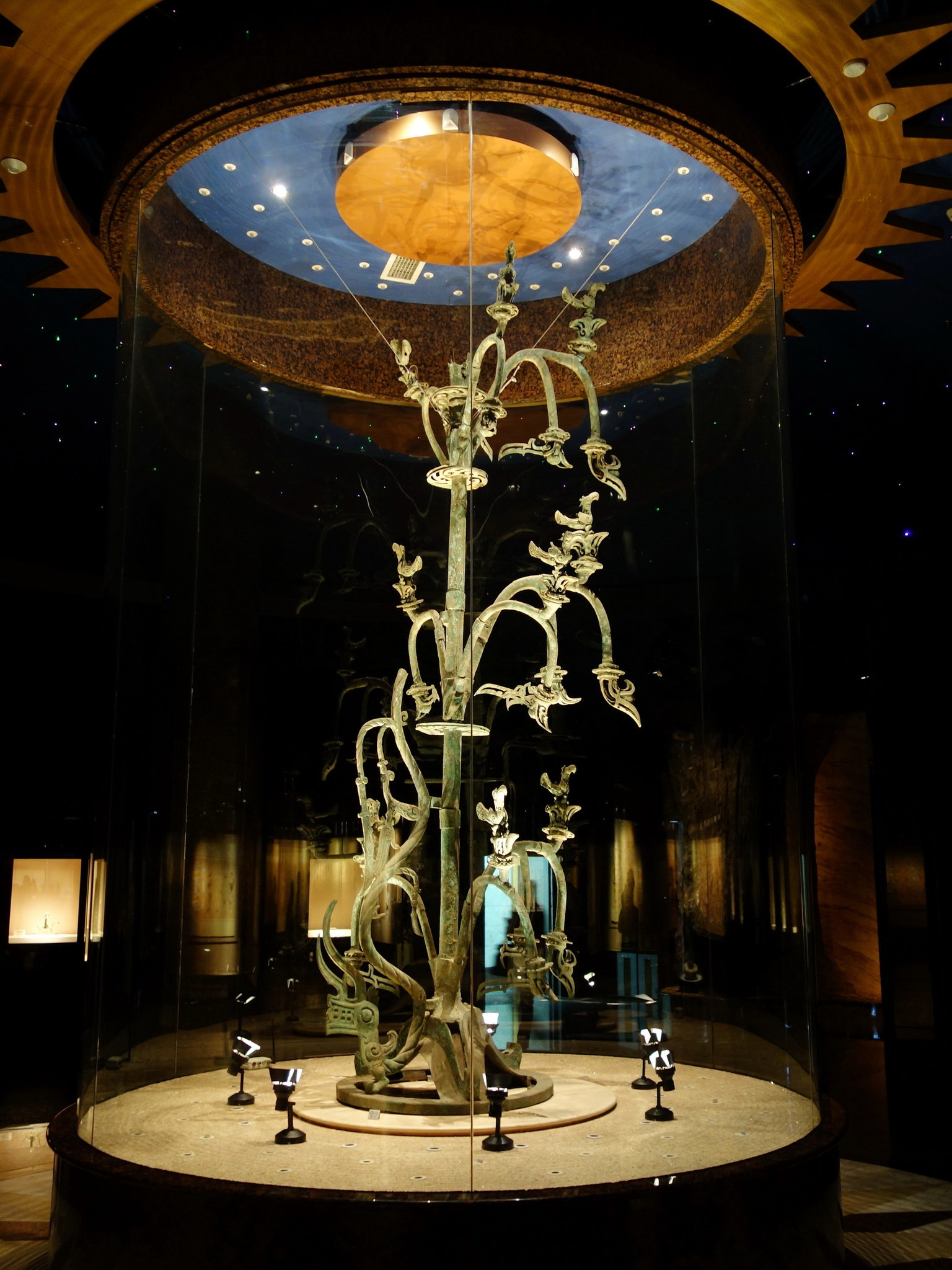
 *Chinesische Bronzekunst
Kunst
CA - Chinesische Kunst Urgeschichte
Sanxingdui Museum
Sichuan Sheng-SC
*Chinesische Bronzekunst
Kunst
CA - Chinesische Kunst Urgeschichte
Sanxingdui Museum
Sichuan Sheng-SC
 Urlaub und Reisen
 Essen und Trinken

 Tänze
Tänze


 Sport
China
Fujian Sheng-FJ
Guangdong Sheng-GD
Guizhou Sheng-GZ
Hongkong Tebiexingzhengqu-HK
Hubei Sheng-HB
Hunan Sheng-HN
Jiangsu Sheng-JS
Jiangxi Sheng-JX
Sichuan Sheng-SC
Taiwan Sheng-TW
Sport
China
Fujian Sheng-FJ
Guangdong Sheng-GD
Guizhou Sheng-GZ
Hongkong Tebiexingzhengqu-HK
Hubei Sheng-HB
Hunan Sheng-HN
Jiangsu Sheng-JS
Jiangxi Sheng-JX
Sichuan Sheng-SC
Taiwan Sheng-TW
 Traditionen
Zhejiang Sheng-ZJ
Traditionen
Zhejiang Sheng-ZJ


 Architektur
